
ABSTRACT
Spatial aspects are often crucial for agriculture-related companies. This paper presents how methods of spatial analysis can help to elaborate regional network planning strategy for a large agricultural bank. Corporate reporting microdata, a novel source for the research of Russian business, were processed and visualized with geographical information system (GIS). The overlay of agribusiness clusters and bank accessibility zones revealed uneven patterns of its current branch network. This approach was applicable as a first step for the location choice strategy. The results allowed us to propose a new office location in order to cover territories for the further development of the bank.
This study shows that geographical information system (GIS) approaches and cartographic visualizations are applicable for the planning of financial enterprises’ physical networks. The work was prepared in cooperation with a Russian bank specialized in agricultural business: since the bank does not use GIS in its regional planning, the results of the work revealed uneven patterns in the branch locations which their analysts took into account in their strategic development. Unique features of the research are the processing of enterprise-level corporate reporting microdata, uncommonly used in spatial studies in Russia and the scientific-based approach to business location.
The development of agriculture in Russia made this economic sector more profitable: as agribusiness became attractive for investments and financial services, major Russian banks started to compete for new clients. The bank studied has competitive advantages (e.g., preferential loans, specialized product lines) in attracting agri-small and medium-sized enterprise (SME). Its strategic goals consider both the branch network and the customer base expansion so the service coverage should be coherent with the effective demand of the key target market.
Branch network development is a multi-stage process applying different principles on varying scopes. Both scientific publications and practical research reveal that spatial factors should be considered in banking office locations (Cliquet, Citation2013) even for small-scale enterprises. (Ono et al., Citation2016). Other studies assume that geographical proximity is especially important in agribusiness for business-to-business (B2B) interactions at the subregional level (Geldes et al., Citation2017).
A large number of highly productive and profitable agricultural enterprises are concentrated within the largest urban agglomerations of Russia. Therefore, the suburbs of Moscow are among the most promising territories for a bank’s physical network development. Our goal was to find the advantages and disadvantages of the bank’s network within Moscow. Moscow as a distinct region consists of two parts: the city itself (‘Old Moscow’) and the territory acquired in 2012 (‘New Moscow’) (Makhrova et al., Citation2013).
Bank office addresses were taken from open sources for the beginning of 2020 and geocoded via the Nominatim service (Nominatim, Citation2021) with Python script. In order to show the bank’s coverage, areas were constructed within a 20-minute drive with the use of a Openrouteservice (ORS) QGIS plugin (ORS, Citation2021), which is based on the Open Street Map (OSM) road network information. Corporate reporting microdata from agribusinesses (address, income) were provided by the SPARK-Interfax database (SPARK-Interfax, Citation2021). Each agribusiness operating in 2019 in Moscow was geocoded, analysed and clustered using the DBSCAN algorithm (eps = 1000, minPts = 3). Cluster analysis helps to show fragmented small enterprises as a single unit of analysis, which is suitable in our case. Each cluster with a total mean income in the period 2014–18, exceeding 0.5 million rubles is presented on the map. The raw version of the map was prepared in QGIS, while the final version () was graphically improved in Adobe Illustrator.
Figure 1. Bank branch network coverage and the distribution of agribusiness in Moscow.
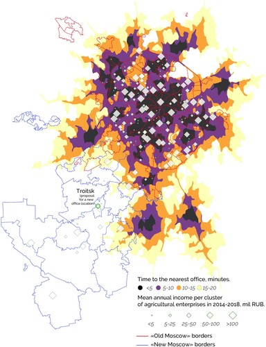
The map shows that the bank covers almost the entire territory of ‘Old Moscow’, except the Zelenograd exclave. ‘New Moscow’ on the south-west of the city remains uncovered by the bank’s offices. A significant portion of organizations in the central part of Moscow are represented by the headquarters of large-scale enterprises that do not consider geographical proximity to a bank as an important factor. The real producers (greenhouses, dairy farms, etc.) are located either in the Moscow region or in ‘New Moscow’.
According to our observations and analysis, the best point for the bank’s network development is the town of Troitsk – the unofficial capital of ‘New Moscow’. First, the service zone around Troitsk would cover most of ‘New Moscow’ and expand the bank’s influence on this market. Second, the service zone would cover existing agri-SME in ‘New Moscow’. Finally, because of the comparably low real estate prices (Makhrova & Kirillov, Citation2018), this territory is the most suitable part of Moscow for the development of highly intensive suburban agriculture – a promising sector for the bank.
This method has some limitations. While it works well for other large agglomerations (a similar approach was applied for St Petersburg), attempts to use it for rural areas were not as successful. The reasons for this are the poorer data coverage in OSM and the lower quality of enterprise microdata. The analysis based on this method also requires an understanding of the territory and geovisual analytic techniques (Andrienko et al., Citation2007). However, the approach could be a first step to define the approximate location for regional network expansion. A specific location could be chosen by further, lower level analysis considering different geographic and marketing factors.
DISCLOSURE STATEMENT
No potential conflict of interest was reported by the authors.
Additional information
Funding
REFERENCES
- Andrienko, G., Andrienko, N., Jankowski, P., Keim, D., Kraak, M-J, MacEachren, A., & Wrobel, S. (2007). Geovisual analytics for spatial decision support: Setting the research agenda. International Journal of Geographical Information Science, 21(8), 839–857. https://doi.org/https://doi.org/10.1080/13658810701349011
- Cliquet, G. (Ed.). (2013). Geomarketing: Methods and strategies in spatial marketing. Wiley.
- Geldes, C., Heredia, J., Felzensztein, C., & Mora, M. (2017). Proximity as determinant of business cooperation for technological and non-technological innovations: A study of an agribusiness cluster. Journal of Business & Industrial Marketing, 32(1), 167–178. https://doi.org/https://doi.org/10.1108/JBIM-01-2016-0003
- Makhrova, A. G., & Kirillov, P. L. (2018). Trends in the development of the new Moscow sector of the metropolitan agglomeration. Regional Research of Russia, 8(3), 238–247. https://doi.org/https://doi.org/10.1134/S2079970518030048
- Makhrova, A. G., Nefedova, T. G., & Treivish, A. I. (2013). Moscow agglomeration and ‘New Moscow’: The capital city-region case of Russia’s urbanization. Regional Research of Russia, 3(2), 131–141. https://doi.org/https://doi.org/10.1134/S2079970513020081
- Nominatim. (2021). https://nominatim.org/
- Ono, A., Saito, Y., Sakai, K., & Uesugi, I. (2016). Does geographical proximity matter in small business lending? Evidence from changes in main bank relationships (HIT-REFINED Working Paper Series 40).
- ORS. (2021). Openrouteservice.org by HeiGIT | Map data © OpenStreetMap contributors. https://openrouteservice.org/
- SPARK-Interfax. (2021). https://www.spark-interfax.ru/