
ABSTRACT
Water body extraction is an important part of water resource management and has been the topic of a number of research works related to remote sensing for over two decades. Extracting water bodies from satellite images with a pixel-based method or indexes cannot eliminate other objects that have a low albedo, such as shadows and built-up areas. Since their spectral differences cannot be separated, in this paper a method that combines a pixel-based index and object-based method has been used on a Sentinel-2 satellite image with a resolution of 10 m. The method uses image segmentation on a multispectral image containing 13 bands. It also uses indexes used for extracting water bodies, such as the Normalized Difference Water Index (NDWI). Two study areas with different characteristics have been chosen, one mountainous and one urban region, both of them located in Macedonia. Using object-based techniques and pixel-based indexes, such as NDWI, the results from the NDWI have been improved by a kappa value of more than 0.5.
Introduction
Water body extraction has become a very important part of remote sensing science since water monitoring plays an important role in water resource management. Water body extraction from remotely sensed images has been a problem for over two decades. A number of indexes have been developed over the years in order to try to eliminate misleading information, such as topographic shadows, cloud shadows, built-up areas, snow and ice. The reason for the abovementioned misleading information comes from the difficulty in distinguishing water from other surfaces with a low albedo. Although the indexes have been improved over the years, there is still a need for more efforts in water body extraction to effectively maintain water resources (Li, Zhang, Xu, Citation2014).
Extracting water from satellite images has been conducted in many research areas. Starting in 1995, the first Normalized Difference Water Index (NDWI) (Gao, Citation1995) was developed. To date, many other indexes and methods have been developed (Ding, Citation2009; Feyisa, Meilby, Fensholt, & Proud, Citation2014; Lacaux, Tourre, Vignolles, Ndione, & Lafaye, Citation2007; McFeeters, Citation1996; Meng, Zhu, Cao, Xsu, & Cao, Citation2013; Pereira-Cardenal et al., Citation2011; Rogers & Kearney, Citation2004; Xiao, Zhao, & Zhu, Citation2010; Xu, Citation2006; Yan, Zhang, & Zhang, Citation2007; Yuanzheng, Zhen Guo, Kaipeng, Dan, & Zhouab, Citation2016), however, they still face the same problems. In a recent study, a method that uses NDWI (McFeeters, Citation1996) and land surface temperature was developed, improving the results by more than 80% (Kaplan & Avdan, Citation2016).
In addition, pixel-based classification can be used for classifying water areas. The two pixel-based classifications are unsupervised and supervised classifications. In unsupervised classification, pixels are grouped based on the reflectance properties of the pixels and the created groups are called “clusters”. The number of clusters should be identified by the user. The two main clustering algorithms are K-means and ISODATA. Supervised classification is done by selecting representative samples for each land cover class in the image, and the classification of the land cover is based on the spectral signatures defined by the user.
Object-based or object-oriented image analysis (OBIA) classification thus supports the use of multiple bands for multiresolution segmentation and classification. Although OBIA has been used for decades (Câmara, Souza, Freitas, & Garrido, Citation1996; Flanders, Hall-Beyer, & Pereverzoff, Citation2003; Kettig & Landgrebe, Citation1976; Ryherd & Woodcock, Citation1996; Strahler, Woodcock, & Smith, Citation1986), in the last few years it has been used frequently in different study areas, such as vegetation (Yu et al., Citation2006), forest cover (Heyman, Gaston, Kimerling, & Campbell, Citation2003) and water body extraction (He, Zhang, & Hua, Citation2016). The publication of papers related to OBIA has drastically increased since 1995 (Blaschke, Citation2010). As the spatial resolution of the imagery is an important factor when selecting image classification techniques (Blaschke, Citation2010), OBIA is superior to traditional pixel-based classification. It has been suggested that for high-resolution imagery, object-based classification should be used and for medium/low-resolution imagery, pixel-/object-based classification should be used (gisgeography, Citation2016). Most of the studies for object-based classification use high-resolution imagery, such as IKONOS, QuickBird (He et al., Citation2016), SPOT (Polychronaki & Gitas, Citation2012) or images from unmanned aerial vehicle (Comert, Avdan, & Avci, Citation2016).
Not being able to completely extract water bodies from satellite images with methods or algorithms has necessitated a solution to find links between water indexes and the rapidly growing OBIA.
In this paper, first, a comparison was made between the NDWI, pixel-based (supervised and unsupervised) classification and object-based classification. Then, a new water body extraction model was developed using the advantages of the OBIA and the NDWI from Sentinel-2 with a 10-meter resolution. The need for this kind of method comes from the fact that it is hard for pixel-based classification methods and the NDWI method to separate water from another object that has a low albedo, and since it is impossible to separate them by their spectral differences, we have decided to include the NDWI within the object-based method. The model developed in this work was built in eCognition software.
Materials and methods
Study area and data
The Republic of Macedonia was chosen as the study area in this paper (). Macedonia is a landlocked country geographically defined by a central valley formed by the Vardar River and framed along its borders by mountain ranges. Two different areas with complex characteristics have been selected: an urban region, where the built-up areas and dark objects affect the results of water body extraction analysis of the Vardar River in the capital, Skopje (), and a mountainous region characterized by high mountains causing topographic shadows, clouds, cloud shadow, snow and ice that have an impact on the water body extraction results of analysing the Kozjak Dam (). The Sentinel-2 satellite image was acquired on 18 March 2016 because of the presence of snow, clouds and topographic shadows. The Sentinel-2 satellite is part of the Earth observation mission developed by the European Space Agency and was launched on 23 June 2015 (Nowakowski, Citation2015). The satellite carries a single multi-spectral instrument (MSI) with 13 spectral channels, which use the push-broom concept. The resolution varies between 10 and 60 m. The visible and near-infrared (NIR) bands have 10, the vegetation red edge bands (5.6 and 7) and the shortwave infrared (SWIR) bands have 20, and the rest of the bands have 60-m resolution (Agancy, Citation2015) ().
Figure 1. (a) Republic of Macedonia, (b) Sentinel frame, (c) urban region; (d) mountainous region composed with SWIR, blue and green bands.
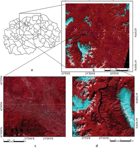
Table 1. Sentinel-2 band characteristics.
Methods
As mentioned before, a number of pixel-based indexes have been developed for water body extraction from satellite images, but most of them do not have the required accuracy and produce a number of errors, mostly caused by shadows and built-up areas (Kaplan & Avdan, Citation2016). A comparison was made between NDWI, pixel-based (unsupervised and supervised) classification and object-based classification. The NDWI method used in this paper uses the green and NIR bands (McFeeters, Citation1996) since it was intended to never fail at water body extraction (Kaplan & Avdan, Citation2016).
For the pixel-based classification, both unsupervised and supervised classifications were performed. For the unsupervised classification, the K-means clustering method was used with six classes. For the supervised classification, six representative samples from the image were selected. The representative samples were different in the study areas since the study areas have different characteristics. For the urban study area, water, streets, an urban area, an industrial area, vegetation, and agricultural areas have been selected, and for the second, a mountainous region, water, snow, clouds, shadows, vegetation and bare land have been selected.
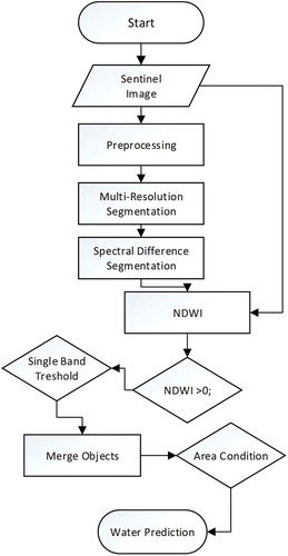
The most important part of the object-based classification is segmentation. After pre-processing the satellite image, segmentation was performed. Several object-oriented image segmentation algorithms are divided into two groups: bottom-up algorithms (chessboard, quad-tree and multiresolution segmentation) and top-down algorithms (contrast split, spectral difference and multi-threshold segmentation). Two segmentations were used in the algorithm in this developed work. The first, bottom-up, is multiresolution segmentation, which creates objects using an interactive algorithm, whereby pixels are grouped until a given threshold is reached (Baatz & Schäpe, Citation2010). The variance threshold is weighted, and in this work, importance was given to NIR (band 4) values since the water areas near infrared values are lower than other areas. The scale parameter (as an abstract value) determines the maximum possible change of heterogeneity, and it is indirectly related to the size of the created object. Compactness describes the closeness of pixels clustered in an object by comparing it to a circle. The parameters used in this paper are shown in . Multiresolution segmentation was selected over bottom-up segmentation, since chessboard segmentation splits the image object domain into square image objects, which makes it useless for representing meaningful objects, and quadtree-based segmentation splits the image object domain into a quadtree grid formed by square objects (Ouyang,).
Table 2. Mutli-resolution segmentation parameters.
Table 3. Kappa accuracy assessment analysis.
The second segmentation, spectral difference segmentation, is a merging algorithm where neighbouring objects with a spectral mean below the given threshold (in this case 100) are merged. In order to reduce the errors, in this paper, we employed an object-based method including NDWI analysis. The method uses image segmentation on the multispectral image containing 13 bands and the indexes used for extracting water bodies, such as the NDWI.
Spectral difference segmentation was selected over the other two top-down algorithms because of its ability to merge neighbouring objects with the spectral mean.
After the second segmentation, NDWI analyses were performed on the study areas and then classified into two classes: smaller and bigger than the zero value. Furthermore, a single-band threshold was assigned to the SWIR band since it was noted that the water had recognizably lower SWIR values than the other object. The neighbour objects that were classified as water areas were merged, giving us a clear image of the water areas. As a last condition, small areas were excluded from the results. For the built-up study area, an additional condition for the single-band threshold was used that excluded some of the building roofs from the industrial area that had a significantly low green value. The flowchart of the methodology is presented in .
Figure 2. Flowchart of the methodology.
For the accuracy of assessment and comparison between the methods, unsupervised and supervised classifications were performed. In both cases, six classes were assigned. In the supervised classification of the mountainous region, two types of vegetation, snow, clouds, water and mountain shadows were assigned; for the urban region, industrial area, streets, water, shadows, urban area and vegetation classes were assigned.
Results and discussion
and show the water body extraction results from the object-based classification used in this paper, the NDWI analysis and the pixel-based (unsupervised and supervised) classifications. The results from the NDWI analysis show that the method successfully extracts water body areas in both study areas, but failed to eliminate most of the misleading information in both cases. In the urban region, some parts were classified as water, possible building shadows, dark objects or asphalt. In the mountainous region, most of the misleading information was classified as mountain or cloud shadows. Since the NDWI method was developed for Landsat satellite images and the threshold is suggested to be specified at zero (McFeeters, Citation1996), for Sentinel satellite images, we suggest that the threshold should be higher than zero (in this case, 0.1).
Figure 3. Results from the mountainous region: (a) RGB 12,2,3 band combination; (b) NDWI results; (c) unsupervised classification results; (d) supervised classification results; (e) object-based classification results, (f) object-based classification results (yellow border) on Google Earth image.
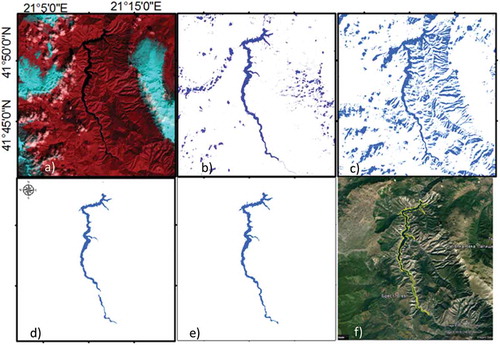
Figure 4. Results from the urban region: (a) RGB 12,2,3 band combination, (a-1) RGB 12,2,3 band combination detail; (b) NDWI results, (b-1) NDWI results detail; (c) results from the unsupervised classification, (c-1) results from the unsupervised classification detail; (d) results from the supervised classification, (d-1) results from the supervised classification detail; (e) results from the object-based classification, (e-1) results from the object-based classification detail.
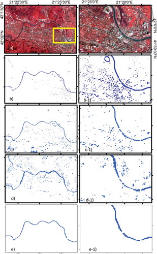
For the pixel-based classification, both unsupervised and supervised, six classes were assigned. In the unsupervised classification, the most misleading information came from urban object shadows in the urban region and topographic and cloud shadows in the mountainous area. It was observed that in the unsupervised classification, the higher the number of classes, the more clearly water objects were separated from other areas. In the supervised classification, unexpectedly, the accuracy was lower than that of the unsupervised classification.
The object-based classification, as expected, gave the best results in the accuracy analysis and did not show any misleading information, but some very small water objects and rivers were not identified as water ( and ). The reason for the failure of the extraction of some small water areas is the condition set in the last step of the developed algorithm, where the purpose was to eliminate shadows from buildings in the urban region.
The extraction accuracy was achieved using kappa statistics with 100 random points in each area. It was observed that the results from the object-based method, in comparison with the results from the pixel-based method, improved the kappa coefficient values by approximately 0.5 in both cases. For the first area, the overall accuracy of the object-based classification was over 90% with the kappa coefficient 0.88, while for the second study area, the kappa was 0.9 ().
. Kappa accuracy assessment analysis.
As pixel-based indexes often cause errors in water extraction because of the water’s low spectral signature, confusing the other areas with topographic shadows, cloud shadows, snow, ice and built-up areas, there is a need to find a solution that will give satisfactory results. For pixel-based classification, it is hard to distinguish the water from other low-albedo objects because the analysis uses only spectral values. Since it is hard to distinguish water from other areas with similar spectral characteristics, in this paper, a combination of the object-based method and NDWI was used. Object-based methods basically use high-resolution imagery, but in this case, Sentinel-2 satellite imagery was used with between 10- and 60-m resolution, and the results were considered to be satisfactory. The method contains segmentations, NDWI analysis and geometric and single-band thresholds. It was observed that the results from the object-based method in comparison with the pixel-based method showed improvement, with a kappa value of 0.5. The advantage of this method is that it can be used on satellite images that do not have a very high resolution, but still show good results. The disadvantage of this method is that it can exclude some small water areas from the results. Nevertheless, this should be a human-made decision depending on what is needed and what kinds of results are expected. In this paper, some small water areas were excluded on purpose with the area condition. For future research, a universal method for any kind of study area can be considered, which would be challenging since every area has its own characteristics.
Conclusions
Taking into consideration that previously made efforts for water extraction either used pixel- or object-based methods from high-resolution imagery, this work combines both the pixel-based index and object-based methods with a 10- to 60-m-resolution satellite image from Sentinel-2. Since pixel-based methods cannot separate water from other areas with a low albedo, in this work, we decided to add the NDWI to the object-based method. The idea of combining both methods for a 10-m-resolution image gave results that cannot be retrieved by using only the pixel-based index or pixel-based classification method. Although pixel-based methods have been used for over two decades and some improvements have been made to them, they are less accurate when utilized for mountainous, snowy, cloudy and urban areas. This kind of study can be useful in any field connected to water monitoring. It is also very suitable for use on mountainous or any other area for determining changes on specific water bodies. The improvement of water extraction was expected since the object-based method uses not only the multi-spectral characteristics of the images but also additional characteristics defined by the user. The disadvantage of NDWI in comparison with the pixel- and object-based classifications is the use of only two bands. Pixel-based classification can give very good results for water extraction, but the number of classes is very important and it can take a significant amount of time. The biggest advantage of object-based classification is that it can be conducted very fast and the results are satisfactorily accurate.
Disclosure statement
No potential conflict of interest was reported by the authors.
References
- Agancy, E. S. (2015). Sentinel-2 MSI: Overview. https://sentinel.esa.int/documents/247904/685211/Sentinel-2_User_Handbook.
- Baatz, M., & Schäpe, A. (2010). Multiresolution segmentation: An optimization approach for high quality multi-scale image segmentation. AGIT-Symposium Salzburg 2000, 12–23.
- Blaschke, T. (2010). Object based image analysis for remote sensing. ISPRS Journal of Photogrammetry and Remote Sensing, 65(1), 137–143. doi:10.1016/j.isprsjprs.2009.06.004
- Câmara, G., Souza, R.C.M., Freitas, U.M., & Garrido, J. (1996). SPRING: Integrating remote sensing and GIS by object-oriented data modelling. Computers & Graphics, 20(3), 395–403. doi:10.1016/0097-8493(96)00008-8
- Comert, R., Avdan, U., & Avci, Z.D.U. (2016). İnsansız Hava Aracı Verilerinden Nesne Tabanlı Bina Çıkarımı. In Uzaknda algilama Ve CBS sempozyumu.
- Ding, F. (2009). Study on information extraction of water body with a new water index (NWI). Science of Surveying and Mapping, 34(4), 155–158.
- Feyisa, G.L., Meilby, H., Fensholt, R., & Proud, S.R. (2014). Automated water extraction index: A new technique for surface water mapping using Landsat imagery. Remote Sensing of Environment, 140, 23–35. doi:10.1016/j.rse.2013.08.029
- Flanders, D., Hall-Beyer, M., & Pereverzoff, J. (2003). Preliminary evaluation of eCognition object-based software for cut block delineation and feature extraction. Canadian Journal of Remote Sensing, 29(4), 441–452. doi:10.5589/m03-006
- Gao, B.C. (1995). A normalized difference water index for remote sensing of vegetation liquid water from space. Imaging Spectrometry, 2480, 225–236. doi:10.1117/12.210877
- gisgeography. (2016). Image classification techniques in remote sensing. http://gisgeography.com/image-classification-techniques-remote-sensing/
- He, Y.R., Zhang, X.X., & Hua, L.Z. (2016). Object-based distinction between building shadow and water in high-resolution imagery using fuzzy-rule classification and artificial bee colony optimization. Journal of Sensors, 2016, 1–10. doi:10.1155/2016/2385039
- Heyman, O., Gaston, G.G., Kimerling, A.J., & Campbell, J.T. (2003). A per-segment approach to improving aspen mapping from high-resolution remote sensing imagery. Journal of Forestry, 101(4), 29–33.
- Kaplan, G., & Avdan, U. (2016). New mapping technique for water extraction using NDWI and land surface temperature – water extraction surface temperature index. In Manuscript submitted for publication.
- Kettig, R.L., & Landgrebe, D. (1976). Classification of multispectral image data by extraction and classification of homogeneous objects. IEEE Transactions on Geoscience Electronics, 14(1), 19–26. doi:10.1109/TGE.1976.294460
- Lacaux, J., Tourre, Y., Vignolles, C., Ndione, J., & Lafaye, M. (2007). Classification of ponds from high-spatial resolution remote sensing: Application to rift valley fever epidemics in senegal. Remote Sensing of Environment, 106(1), 66–74. doi:10.1016/j.rse.2006.07.012
- Li, B.Y., Zhang, H., & Xu, F.J. (2014). Water extraction in high resolution remote sensing image based on hierarchical spectrum and shape features. 35th International Symposium on Remote Sensing of Environment 17(Isrse35), 012123. doi:10.1088/1755-1315/17/1/012123
- McFeeters, S.K. (1996). The use of the normalized difference water index (NDWI) in the delineation of open water features. International Journal of Remote Sensing, 17(7), 1425–1432. doi:10.1080/01431169608948714
- Meng, W., Zhu, S., Cao, Xsu, W., & Cao, B. (2013). Establishment of synthetical water index. Science of Surveying and Mapping, 38(4), 130–133.
- Nowakowski, T. (2015). Arianespace successfully launches Europe’s Sentinel-2A earth observation satellite. In Spaceflight insider. http://www.spaceflightinsider.com/missions/earth-science/arianespace-successfully-launches-europes-sentinel-2a-earth-observation-satellite/
- Pereira-Cardenal, S.J., Riegels, N.D., Berry, P.A.M., Smith, R.G., Yakovlev, A., Siegfried, T.U., et al. (2011). Real-time remote sensing driven river basin modeling using radar altimetry. Hydrology and Earth System Sciences, 15(1), 241–254. doi:10.5194/hess-15-241-2011
- Polychronaki, A., & Gitas, I.Z. (2012). Burned area mapping in greece using SPOT-4 HRVIR images and object-based image analysis. Remote Sensing, 4(2), 424–438. doi:10.3390/rs4020424
- Rogers, A.S., & Kearney, M.S. (2004). Reducing signature variability in unmixing coastal marsh thematic mapper scenes using spectral indices. International Journal of Remote Sensing, 25(12), 2317–2335. doi:10.1080/01431160310001618103
- Ryherd, S., & Woodcock, C. (1996). Combining spectral and texture data in the segmentation of remotely sensed images. Photogrammetric Engineering and Remote Sensing, 62(2), 181–194.
- Strahler, A.H., Woodcock, C.E., & Smith, J.A. (1986). On the nature of models in remote sensing. Remote Sensing of Environment, 20(2), 121–139. doi:10.1016/0034-4257(86)90018-0
- Xiao, Y., Zhao, W., & Zhu, L. (2010). A study on information extraction of water body using bandl and band7 of TM imagery. Science of Surveying and Mapping, 35, 226–227,216.
- Xu, H.Q. (2006). Modification of normalised difference water index (NDWI) to enhance open water features in remotely sensed imagery. International Journal of Remote Sensing, 27(14), 3025–3033. doi:10.1080/01431160600589179
- Yan, P., Zhang, Y., & Zhang, Y. (2007). A study on information extraction of water enhanced water index (EWI) and GIS system in semi-arid regions with the based noise remove techniques. Remote sensing information (pp. 62–67).
- Yu, Q., Gong, P., Clinton, N., Biging, G., Kelly, M., & Schirokauer, D. (2006). Object-based detailed vegetation classification with airborne high spatial resolution remote sensing imagery. Photogrammetric Engineering & Remote Sensing, 72(7), 799–811. doi:10.14358/PERS.72.7.799
- Yuanzheng, L.X., Zhen Guo, G., Kaipeng, X., Dan, H., & Zhouab, H. (2016). An index and approach for water extraction using landsat–OLI data. International Journal of Remote Sensing. doi:10.1080/01431161.2016.1201228