
ABSTRACT
Observations in thermal infrared (IR) contribute substantially to the understanding of the global fluxes of energy and matter between Earth’s surface, ocean and atmosphere. Key parameters derived from such observations are Sea Surface Temperature (SST), Land Surface Temperature (LST) and Land Surface Emissivity (LSE). These variables are important for weather forecasting and climate modelling. However, satellite systems currently in orbit provide only a small number of spectral bands in the thermal region, and consequently cannot be used for temperature emissivity separation (TES) to accurately derive LST and LSE. Hence, capacities to investigate processes or phenomena where LST in high temporal and high spatial resolution (<100 m) is required, such as agricultural applications or urban heat island monitoring, are limited. Additionally, the measurement of radiative energy released from active large and small fires, which contribute significantly to greenhouse gas emissions, is still challenging with current IR systems. Here, we introduce the proposed multispectral sensor system DIEGO (Dynamic Infrared Earth Observation on the ISS Orbit) with 11 spectral bands and a ground sampling distance of less than 60 m, which aims to reduce the observation gap in the thermal infrared significantly.
Introduction
Climate change is affecting the Earth system to an unprecedented extent and intensity, causing severe socioeconomic and ecological consequences. In 2017, the global average carbon dioxide (CO2) concentration in the Earth’s atmosphere reached 405 ppm (parts per million), a level not seen in climate records of the last 800,000 years (Gamillo, Citation2018). The levels of greenhouse gases are still rising and even faster than they did during the 1990s (Gamillo, Citation2018; Hopkin, Citation2007). Thermal infrared sensors provide key capacities to improve our understanding of climate change by assessing hot sources as well as ambient temperature of land and sea surfaces. Wildfires and peat fires affect the global climate severely, because they release large amounts of greenhouse gases and aerosols. Twenty-four percent of greenhouse gas emissions are related to agriculture, forestry and other land use, which includes land-based CO2 emissions from vegetation fires, peat fires and peat decay (Intergovernmental Panel on Climate Change (IPCC), Citation2014). The net contribution of vegetation fires and peat fires to global warming is estimated to be about 6% of the fossil fuel emissions with considerable inter-annual variability, and the contribution of small fires is one of the factors still causing substantial uncertainties (Van Der Werf et al., Citation2017). The total anthropogenic effective radiative forcing over the Industrial Era is 2.3 Wm2 (Intergovernmental Panel on Climate Change (IPCC), Citation2014; Myhre et al., Citation2013). Satellite-derived Land Surface Temperature (LST) and Sea Surface Temperature (SST) products are considered to be among the most important variables in order to understand global energy flux from micro to mesoscale (Merchant et al., Citation2013; Sobrino, Jiménez-Muñoz, & Paolini, Citation2004). The challenge to retrieve correct LST products is to estimate Land Surface Emissivity (LSE) accurately (Moscadelli, Diani, & Corsini, Citation2017). Therefore, temperature and emissivity need to be separated from at-sensor thermal radiance.
LST is driven by incoming solar longwave irradiation, outgoing terrestrial radiation, sensible-, latent- and ground heat fluxes (Dash, Citation2005). Consequently, LST and SST can be used as an indicator for the energy balance of the Earth. These datasets are important for different applications such as numerical weather prediction, climate simulations or vegetation monitoring. LSE is not only necessary for an accurate estimation of surface energy budgets (Jin & Liang, Citation2006); it can be also used as an indicator of the composition of different materials. It is especially suited for the determination of silicate minerals, bedrock mapping and resource exploration (Ninomiya, Citation2004).
The estimation of LST is further complicated by its dependency not only on surface parameters, but also on atmospheric effects and viewing angles, which can lead to uncertainties of up to 5 K and more (Li et al., Citation2013; Prata, Caselles, Coll, Sobrino, & Ottlé, Citation1995). Consequently, there is a large deviation of retrieved LST measurements related to different LSE retrieval methods (Li et al., Citation2013).
A number of thermal sensors are in orbit, providing data for different applications. For instance, MODIS (Moderate-resolution Imaging Spectroradiometer, on Terra and Aqua satellites), VIIRS (Visible Infrared Imaging Radiometer Suite, on S-NPP and JPSS), SEVIRI (Spinning Enhanced Visible and InfraRed Imager, on Meteosat Second Generation), and SLSTR (Sea and Land Surface Temperature Radiometer, on Sentinel-3) provide data in mid-wavelength infrared (MWIR) as well as in long-wavelength infrared (LWIR), often referred to as thermal infrared (TIR), with low to medium spatial resolution (≥375 m). MWIR data from these sensors are suitable to investigate high-temperature anomalies such as larger landscape fires, whereas LWIR is used to retrieve LST or SST. These sensors provide data at a high temporal, albeit low spatial resolution. Satellite missions such as FireBIRD, Landsat 7 and Landsat 8 feature TIR sensors with a higher spatial resolution of 180 m, 60 m and 100 m, respectively, but they only have a limited number of one or two bands in the thermal domain and a high revisit time (Ruecker, Menz, Heinemann, Hartmann, & Oertel, Citation2015).
Since 2018, the ECOSTRESS (Ecosystem Spaceborne Thermal Radiometer Experiment on Space Station) TIR sensor is installed on the International Space Station (ISS) with a higher spatial and spectral resolution than Landsat 7 in the thermal bands. This sensor is based on the existing space-ready prototype of HyspIRI’s (Hyperspectral Infrared Imager). Due to the sensor design and ISS speed, the ECOSTRESS pixels are asymmetric with 38 m in-track and 69 m cross-track. The sensor has five spectral bands in the 8–12.5 μm range and one additional band at 1.6 μm, e.g. for geolocation and cloud detection (https://ecostress.jpl.nasa.gov/instrument). ECOSTRESS measures the temperature of plants in order to determine plant health and water use (Hulley, Hook, Fisher, & Lee, Citation2017). Main scientific questions addressed are hence related to observation of water availability, vegetation water stress and agricultural vulnerability (https://lpdaac.usgs.gov/documents/339/ECO4ESIALEXIU_PSD_V1.pdf)
ECOSTRESS is designed to observe 22 target areas or swaths in 24 h, each measuring 400 by 400 km, but NASA managed to increase spatial coverage with a focus on the USA (https://www.jpl.nasa.gov/news/fact_sheets/ecostress-factsheet.pdf). ECOSTRESS has no spectral bands in MWIR and it is not dedicated to quantify high-temperature events like wildfires and related variables such as Fire Radiative Power (FRP).
In contrast, the German FireBIRD mission consists of two small satellites launched in 2012 and 2016, respectively, which are designed to detect high-temperature events and anomalies such as fires (Lorenz et al., Citation2015; Zhukov, Lorenz, Oertel, Wooster, & Roberts, Citation2006). Both FireBIRD satellites are equipped with two spectral bands in the thermal domain: one MWIR one LWIR and additionally three bands in visible and near-infrared (Lorenz et al., Citation2015).
In summary, even though several sensors include thermal bands, there is still a lack of multispectral thermal sensors in the LWIR (at 8–14 µm) with a spatial resolution below 100 m, suitable for the investigation of ambient temperatures, and also at least one band in the MWIR (at 3–5 µm) with a very high radiometric dynamic range to detect and quantify high-temperature events without saturating while observing strong high-temperature events and at the same time not missing small fires.
The multispectral DIEGO (Dynamic Infrared Earth Observation on the ISS Orbit) sensor with 11 spectral bands is aiming to reduce the observation gap in LWIR and MWIR significantly and to provide data for many scientific fields including meteorology, oceanography, climatology, agricultural and forest sciences, volcanology, geomorphology, and environmental sciences. In the following chapters, different sensors for Earth observation on the ISS are introduced and the characteristics of ISS-born Earth observation are discussed. Finally, the DIEGO sensor concept and its applications are described.
ISS-borne earth observation
In the past, Earth observation was mainly satellite-based. With novel, sophisticated sensor systems and at a relatively low cost, ISS-borne remote sensing is becoming more important (Stavros et al., Citation2017). The ISS is a habitable satellite in low Earth orbit (approx. 400 km) with a weight of 450 t and a length of 109 m. Its sun-asynchronous orbit (the solar illumination at any location changes as the orbit processes) allows to address several scientific fields and to investigate processes at different day- and night-times, which is particularly beneficial for thermal remote sensing (Hulley et al., Citation2017). The ISS has the ability to host several instruments simultaneously, collecting a variety of parameters at synergetic spatial resolutions and coordinated temporal acquisition, which is crucial for environmental applications (Stavros et al., Citation2017). In the past, several sensors such as HICO (hyperspectral imaging of the coastal ocean) (Corson et al., Citation2004), the International Space Station Agricultural Camera (ISSAC) (Olsen, Kim, Ranganathan, & Laguette, Citation2011), RapidScat (Lin & Portabella, Citation2017) or Meteor (Arai et al., Citation2014) were mounted on the ISS. Recently, new systems, like the already mentioned ECOSTRESS or DESIS (DLR Earth Sensing Imaging Spectrometer), were installed. DESIS is the first DLR (German Aerospace Center) instrument for the analysis of hyperspectral data on the ISS. The continuous coverage between 400 and 1,000 nm using 235 closely arranged spectral bands makes DESIS a multi-purpose instrument for different applications such as agriculture, biodiversity, geology and mineralogy, coastal zones and water ecosystems. DESIS has a swath with of 30 km with 30 m spatial resolution (Eckardt et al., Citation2015). Additionally, GEDI, a geodetic-class LIDAR measures canopy heights and vegetation structure to quantify global terrestrial biomass (Neeck, Citation2015). OCO-3 (Orbiting Carbon Observatory-3) installed on the Japanese Experiment Module-Exposed Facility (JEM-EF), is aimed to investigate complex dynamics of the Earth’s atmospheric carbon cycle (Neeck, Citation2015). The combination of different sensors on board of the ISS and the simultaneous data acquisition is helpful to gain deeper insights into the complex interrelations between lithosphere, hydrosphere, biosphere and atmosphere (Stavros et al., Citation2017).
ISS external platforms
The importance of ISS as an Earth observation platform is increasing due to new sensor technology and the opportunity to have easy and relatively inexpensive access to space with external non-commercial and commercial platforms attached to the ISS. Several external platforms suitable for Earth observation payloads are attached to the ISS. JAXA operates its Japanese Experiment Module – Exposed Facility (JEM-EF), an external platform that can hold up to 10 experiment payloads at the same time outside the Japanese Kibo module (Matsuoka et al., Citation2007).
Another platform on the ISS, specifically developed for Earth observation payloads, is the Multi-User-System for Earth Sensing (MUSES), developed and operated by the US company Teledyne Brown Engineering. The German hyperspectral DESIS sensor uses the MUSES platform since August 2018 (https://tbe.com/geospatial/MUSES). Besides MUSES, NanoRacks provides a commercial gateway to space. The platform is designed for Earth and deep space observation and sensor development. NanoRacks offers complete in-house capabilities for payload integration, payload design and development (http://nanoracks.com).
The new Bartolomeo platform – provided by Airbus Defence and Space (ADS) – is already partly attached to the European Columbus Module of the ISS. The name of the platform refers to Bartolomeo Columbus, the younger brother of Christopher Columbus. The sensor name DIEGO refers to Diego Columbus, the son of Christopher Columbus. The Bartolomeo platform will allow hosting of external payloads, providing mostly unobstructed views on planet Earth and outer Space. Several slots provide Nadir and Zenith view, which in most cases is beneficial for Earth observation and geolocation. Bartolomeo will be operated in a collaborative public-private utilization scheme with ESA and NASA. ADS plans to provide an “all-in-one mission service” for the Bartolomeo platform payloads, i.e. payload launch, payload on-orbit installation, commissioning, operation and payload data delivery (https://www.airbus.com/space/human-spaceflight/bartolomeo.html).
DIEGO will use the Bartolomeo platform, which has its own communication system for the transmission of payload scientific data to the Earth, called Optical Space Infrared Downlink System (OSIRIS) Laser Communication Terminal (LCT). The data will be downlinked to an optical ground segment, which consists of eight Optical Ground Stations (OGS), to be spread over the globe between ± 51° latitudes. The OSIRIS LCT on Bartolomeo has a downlink capacity of approximately 3.75 TB per day. Additional data can be transferred via the Ethernet connection based on the existing ISS standard communication link. (https://www.airbus.com/space/human-spaceflight/bartolomeo.html).
DIEGO sensor design and its applications
The DIEGO sensor, mounted on the Bartolomeo platform, will substantially expand existing Earth observation capabilities on the ISS, and it will use the unique advantages of the ISS orbit. The DIEGO sensor design makes it useful for a large variety of applications, all of which have specific requirements regarding temporal, spatial and spectral resolution. The applications of the DIEGO sensor system are summarized in the last section of this chapter.
The DIEGO sensor design
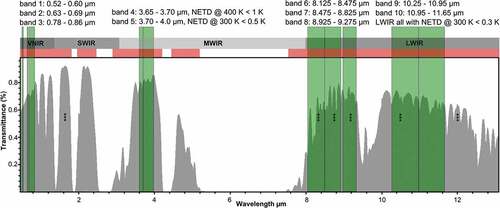
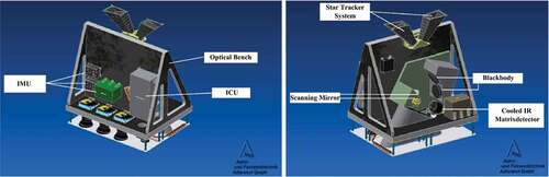
Due to absorption by water vapour and other gases in the atmosphere, two-wavelength windows of 3 to 5 µm (MWIR) and 8 to 13 µm (LWIR) can be used for observation of the upwelling radiation from the surface of the Earth (). For both atmospheric windows, DIEGO is going to provide high-resolution, multispectral data of the Earth’s surface with a ground sampling distance (GSD) of <60 m in the MWIR and LWIR. The DIEGO sensor will consist of different sensor heads: One of them with a cooled mega-pixel detector matrix for multispectral MWIR and LWIR observations and several further heads with uncooled Si-detector arrays for visible (VIS) and near-infrared (NIR) multispectral imaging (see ) with a GSD of 20–30 m. These sensor heads will be mounted and co-aligned on one common optical bench, together with two star trackers and the Inertial Measurement Unit (IMU) (–). This allows to providing geo-referenced multispectral and co-registered image data acquisition in eleven spectral bands:
Three spectral bands for VIS/NIR (VNIR) (0.45–0.9 µm green, red, and NIR)
Two spectral bands for MWIR (3.6–4 µm) mainly dedicated for the observation of high-temperature events with expected pixel temperatures of 400–1000 K
Six spectral bands for LWIR (8–12 µm) for normal temperature phenomena at 250–350 K (see for detailed band specification)
Table 1. Preliminary specification of DIEGO’s sensor system.
Figure 1. Atmospheric transmittance and DIEGO’s spectral bands specification in comparison with ECOSTRESS’s spectral bands marked with ***. DIEGO’s spectral band 11 (not shown) can bee used to enhance atmospheric correction or for CO2 detection, but it is not defined yet. Transmittance is calculated with modtran (http://modtran.spectral.com/modtran_home) for mid-latitude summer, top of atmosphere, 294.2 K.
To provide eight spectral bands in MWIR/LWIR, eight filter stripes are placed in front of the cooled detector matrix. For the VNIR sensors and for the MWIR/LWIR sensor, separate sensor electronics will be used and managed by DIEGO’s Central Instrument Control Unit (see ). The DIEGO MWIR/LWIR sensor will consist of the sensor head, a Scan/Tilt Mirror System (STMS) and two black bodies for radiometric on-board calibration, as shown in the right-hand picture of .
Figure 2. Bartolomeo platform for Earth observation, on the ISS. The platform which is attached to the Columbus module of the ISS allows unobstructed views of the Earth and outer space. Source Airbus.
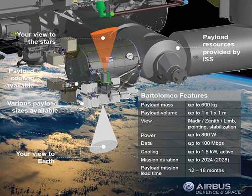
Figure 3. The block diagram of the DIEGO sensor system.
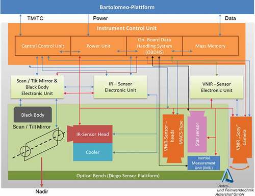
Figure 4. Schematic view of the DIEGO sensor system, showing its nadir looking VNIR cameras in the left picture and its MWIR/LWIR sensor in the right picture.
Most likely a push-whisk broom scan mode of the STMS in front of the IR sensor head will be used, providing a field of view (FoV) of 350 km. Sensor requirements detailed below are based on the key applications of DIEGO in the low temperature (e.g. SST, LST) and high-temperature domain (e.g. fires).
Spectral bands requirements for the detection and characterization of high-temperature events
A large and diverse range of hot sources can be detected and characterized from space, including biomass burning, gas flares, coal fires, volcanoes and industrial hotspots. Considerable advance has been achieved in observing landscape fires using predominantly MWIR sensors, mostly at coarse resolutions of 750 m to >1 km (Justice et al., Citation2002; Roberts & Wooster, Citation2008; Schroeder, Oliva, Giglio, & Csiszar, Citation2014; Zhukov et al., Citation2006). Gas flares have been characterized using MWIR (Anejionu, Citation2019), SWIR (Fisher & Wooster, Citation2018), or – only at nighttime – using all bands at wavelengths from visible to LWIR for the VIIRS sensor (Elvidge, Zhizhin, Hsu, & Baugh, Citation2013) and from SWIR to LWIR for the SLSTR (Caseiro et al., Citation2018) sensor. Their results showed that currently available coarse resolution IR sensors are generally not optimal for observations of gas flares, since these sources have their spectral maximum in the SWIR (1.6–2.5 µm), which can lead to substantial omission errors if only a MWIR band are used for detection (Anejionu, Citation2019). Due to the spatial resolution offered by DIEGO, detection of gas flares can be much improved, but saturation of the sensor may occur when flares are large and hot.
The estimation of fire attributes, like “fire temperature” and “fire area”, from space takes place in the sub-pixel domain. Therefore, operational IR sensors, due to their low spatial resolution, allow the retrieval of fire area and fire temperature of smaller fires only with large uncertainties (Giglio & Kendall, Citation2001; Giglio & Schroeder, Citation2014; Zhukov et al., Citation2006). Multiband nighttime methods developed by Elvidge et al. (Citation2013) for the VIIRS sensor and adopted by Caseiro et al. (Citation2018) for the SLSTR sensor have the potential to reliably estimate fire temperature and area and their uncertainties for hot sources. However, they work only at nighttime when fire activity is low. With two bands in the MWIR and six bands in the LWIR at a spatial resolution of 60 m, both the bi-spectral method using one band in MWIR and one band in LWIR (e.g. Zhukov et al., Citation2006), as well as the multiband retrieval using Planck curve fitting will provide reasonable estimates of fire temperature and area at daytime conditions. Fire temperature is a key element for the characterization of the combustion regime (flaming vs. smoldering combustion) (Giglio & Justice, Citation2003; Yokelson et al., Citation2007). The combustion regime in turn is decisive for the estimation of emission factors for different trace gas species, most notably CO, CO2 and CH4, which is a potent greenhouse gas (Yokelson et al., Citation2007).
At the spatial resolution of 60 m, subpixel fire area can be used to estimate the depth of the flaming front, and together with combustion rates derived from FRP, can be used to determine reaction intensity (Alexander, Citation1982; Kremens, Smith, & Dickinson, Citation2010), which is an important fire intensity measure. Coal-seam fires usually do not produce a strong enough signal to be detected by operational coarse resolution observations (Siegert et al., Citation2004; Tetzlaff, Citation2004) but have been successfully monitored by FireBIRD data with 160 m spatial resolution (Atwood et al., Citation2016). Coal-seam fires have successfully been observed in the SWIR by nighttime ASTER and Landsat ETM sensors at 90 m and 30 m resolution, respectively (Tetzlaff, Citation2004). Observations by the BIRD HSRS sensor (MWIR/LWIR) at 160 m resolution provided a lower number of detections showing that this sensor’s ground resolution was not optimal for observation of coal-seam fires (Tetzlaff, Citation2004). Consequently, even the FireBIRD satellites – featuring the same IR sensor as BIRD, with the highest spatial resolution non-saturating MWIR/LWIR observations available to date, are not well suited for monitoring of coal-seam fires, which are important GHG sources. Building on the heritage of the BIRD (Zhukov et al., Citation2006) and FireBIRD sensors (Lorenz et al., Citation2015), the dynamic range of the DIEGO MWIR/LWIR sensor is achieved by observing hot sources at different integration times, where lower integration times are used for very hot sources to prevent saturation. Since the spatial resolution of DIEGO will be substantially higher than those of BIRD or FireBIRD, the DIEGO sensor must be equipped with two MWIR bands to provide unsaturated data even for extremely hot sources (e.g. gas flares, hot vegetation fires). The broader band MWIR will cover the 3.7 to 4.0 µm spectral range, while the narrowband MWIR will operate at 3.65 to 3.7 µm (see ). This layout and the use of different integration times enables an extremely large dynamic range, which is specifically important for monitoring hot sources together with their “cold” background at high spatial resolution of <60 m. Detailed band specifications and their required radiometric precision, e.g. their noise equivalent temperature difference (NETD) are shown in .
Spectral bands requirements for retrieval of Land Surface Temperature and Land Surface Emissivity
Especially for the investigation of the urban heat island effect (UHI) and to capture intra-urban surface heat patterns, sensors with high precision (see the NETD values in ), high temporal, spectral and spatial resolution (<100 m) are required. In urban areas, the uncertainties in LST and LSE retrieval are still large, depending on the methods used (Li et al., Citation2013). Consequently, DIEGO provides a high spatial and temporal resolution and the spectral characteristics to accurately estimate LSE with LWIR and MWIR. All state-of-the-art temperature emissivity separation methods can be applied to DIEGO data. This includes methods making use of two or more bands in the thermal domain, as well as those requiring only one thermal band, such as NDVI-based approaches (see, e.g., Li et al., Citation2013). Sensors with several bands in the thermal domain and high spatial resolution are especially useful for monitoring of urban areas. In urban areas with a small-scale mixture of surface materials where spatial variability of emissivity is large, an NDVI-based approach with one or two thermal channels is of limited usefulness due to its inability to distinguish between different artificial surfaces (Oltra-Carrió, Sobrino, Franch, & Nerry, Citation2012). At the same time, a spatial resolution below 100 m is required for mapping at scale useful for urban applications (Sobrino, Oltra-Carrió, Sòria, Bianchi, & Paganini, Citation2012). ECOSTRESS on JAXA JEM the and a future DIEGO sensor on Bartolomeo are therefore well suited for this application as they allow to implement multispectral temperature/emissivity separation approaches, such as the TES (Gillespie et al., Citation1998), for retrieving most accurate LST (Hulley, Shivers, Wetherley, & Cudd, Citation2019) at high spatial resolution.
These capabilities to derive LST with high precision is also important for agricultural applications. Currently, only the ECOSTRESS sensor provides thermal data in a sufficient spatial, temporal and spectral resolution to accurately estimate evapotranspiration at local scale and over the diurnal cycle (https://ecostress.jpl.nasa.gov/downloads/atbd/ECOSTRESS_L2_ATBD_CLOUD_2018-06-06.pdf), but the ECOSTRESS sensor is in contrast to DIEGO not capable to derive NDVI. Consequently, ISS based multispectral thermal sensors, like ECOSTRESS and a future DIEGO sensor are capable to derive different drought indices like the Evaporative Stress Index (ESI) for crop water-stress detection (Gerhards, Schlerf, Mallick, & Udelhoven, Citation2019) accurately and with a maximum revisit time of 5 days. (https://ecostress.jpl.nasa.gov/downloads/atbd/ECOSTRESS_L2_ATBD_CLOUD_2018-06-06.pdf) Additionally, all LWIR applications and existing algorithms for ASTER can be used, since the DIEGO spectral band specifications for LWIR are identical (Abrams et al., Citation2015). Complementary information for improved surface characterization can be expected from the link to the ECOSTRESS spectral library (Meerdink, Hook, Roberts, & Abbott, Citation2019).
Spectral bands requirements in the visible and NIR region
Nadir facing visible red and near-infrared channels are needed to effectively discriminate sun glint and bright surfaces from fires (Zhukov et al., Citation2006) and to calculate NDVI for NDVI-based LSE estimation.
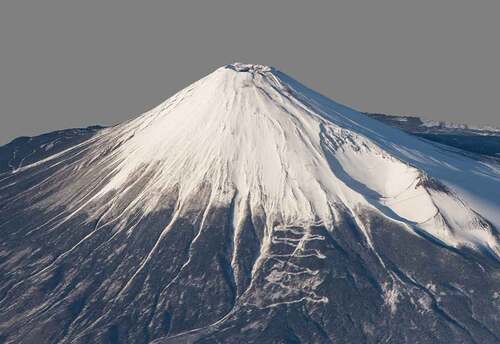
Furthermore, most of the present satellite systems such as Landsat or Sentinel-2 are not capable of deriving stereoscopic images of the Earth’s surface. The DIEGO sensor system will be equipped with a swivel commercial RGB video camera with a GSD of 5 m. This is useful especially for disaster response, as well as for the generation of 3D models, e.g. the injection height of fire smoke plumes. The expected DIEGO 3D capabilities were simulated using 27 ISS astronaut photos of Mount Fuji using Agisoft Metashape Professional © (). The photos represent varying camera angles, light conditions and overlaps, making it difficult to derive a sufficiently accurate 3D model. The challenges and limitations of NASA’s HDEV (High Definition Earth Viewing) video data (Muri, Runco, Fontanot, & Getteau, Citation2017) for low-resolution 3D model generation (GSD of 500 m) were already described (Schultz, Ortwein, & Rienow, Citation2018) and they are similar to those observed for the high-resolution Fuji model presented here. Consequently, a sensor with low light capabilities like a Sony EXMOR® CMOS 35 mm sensor with 12.4 megapixel (0.004 Lux/ISO 409,600, 4K), or even 8K version CMOS is useful. More importantly, the DIEGO video camera is co-aligned and co-registered with all spectral bands. Therefore, time-consuming georeferencing by hand is not necessary. The CMOS camera data allows a fully automated processing of georeferenced 3D models, which can be combined with all 11 spectral bands.
Figure 5. 3D model of Mount Fuji derived from 27 images (ISS046-E-35801 to ISS046-E-35828) taken by astronauts from the ISS. Photos alignment, dens cloud, mesh and texture generation were performed with Agisoft Metashape Professional. The 3D model was georeferenced with five ground control points. The GSD of the final model is 5 m. All ISS photos can be downloaded here: https://eol.jsc.nasa.gov.
Applications of the DIEGO sensor system
The unique inclined equatorial sun-asynchronous orbit of the ISS differs extremely from the orbits of most Earth observation satellites. The ISS passes over locations between 51.6 degrees North and 51.6 degrees South at different day and night-times with a short revisit time, especially at latitudes larger than 40° (see ). Short revisit and even observations at different day- and night-times are beneficial for many applications. In contrast to ECOSTRESS, the DIEGO sensor system can continuously observe the Earth and can deliver multispectral data not only in LWIR, but also in MWIR and VNIR with high temporal, spatial and spectral resolution useful for answering research questions in remote sensing, meteorology, climatology, agriculture and forestry, oceanography, volcanology, biology, geomorphology, glaciology, environmental sciences, soil science, geophysics, atmospheric chemistry, gynecology and fire ecology. For instance, it can be used to monitor wetlands, natural reserves or inland water bodies, or for precision farming and urban planning.
Table 2. Estimated number of DIEGO overflights for different locations and latitudes.
Especially in the field of climate change, high-resolution thermal data of the Earth surface are essential to improve climate simulations and weather predictions. Climate change will challenge ecosystems all over the globe causing severe ecological and socioeconomic consequences (Intergovernmental Panel on Climate Change (IPCC), Citation2018). Impacts of climate change are expected to be severe particularly in cities, and high-resolution thermal urban LST products are needed to assess urban heat island effect against the background of climate change (Estrada, Botzen, & Tol, Citation2017).
Furthermore, DIEGO can be used to validate thermal satellite systems or products with lower spatial resolution. The asynoptic observation cycle of DIEGO is particularly useful to validate data derived from meteorological satellites with lower spatial resolutions. DIEGO can help to gain deeper insight to understand radiation budget and global energy flux on micro, macro and mesoscale, because LST and SST are considered to be the most important products for this application (Anderson et al., Citation2008; Li et al., Citation2013; Sobrino et al., Citation2004). The Earth radiation budget and surface radiation budget are both Essential Climate Variables (ECV) and LST is considered to be of fundamental importance for numerous environmental applications (Merchant et al., Citation2013; Jin & Liang, Citation2006; Sobrino et al., 2004). Accurate LST and SST products that have a high spatial resolution are not only applicable for validation of sensors like MODIS, SLSTR, SEVIRI or VIIRS, but are also useful to investigate Earth system processes, when a high spatial resolution in the thermal region is required, e.g. for the investigation of coastal cold water upwelling, the detection of small warm-water eddies, fog detection, cloud top temperatures and cloud height of thunderstorms, and hurricanes or for glacier monitoring. Furthermore, DIEGO can be used to monitor permafrost melting or for agricultural applications such as drought monitoring, crop disease detection, soil properties characterization or water stress estimation (evapotranspiration) (Khanal, Fulton, & Shearer, Citation2017). Additionally, multispectral thermal sensors such as DIEGO can be used for LSE estimation, exploration and bedrock mapping (Ninomiya, Citation2004).
In contrast to ECOSTRESS with its six spectral bands, DIEGO provides 11 spectral bands with symmetric pixel dimensions. The major difference between DIEGO and ECOSTRESS is the availability of two non-saturating MWIR bands (for observation of high-temperature events) and three nadir facing spectral bands in VNIR (e.g. for sun-glint removal, NDVI-based LSE estimation and vegetation status characterization). Consequently, DIEGO will be capable to investigate high-temperature events such as forest fires, bush fires, peat fires, coal-seam fires, volcanic thermal anomalies or industrial gas flares with highest precision.
Fires contribute significantly to global CO2 emissions (Intergovernmental Panel on Climate Change (IPCC), Citation2014), but especially small fires can only be explored insufficiently on continental scale with current satellite systems. DIEGO has a high dynamic range and is designed to provide unsaturated MWIR and LWIR data permitting to retrieve the ECV “Fire disturbance” component Fire Radiative Power (FRP), even for small fires or industrial gas flares. FRP is linearly correlated with fire fuel consumption and hence emissions (Mota & Wooster, Citation2018; Wooster, Roberts, Perry, & Kaufman, Citation2005) and therefore, is part of the Global Climate Observing System (GCOS) with respect to the ECV Fire disturbance (Kaiser et al., Citation2012; Ruecker et al., Citation2015; Zhukov et al., Citation2006).
Additionally, DIEGO’s high-resolution 4K swivel video camera can be used for disaster response, to derive 3D models, to estimate cloud or injection height of fire smoke plumes, to investigate meteorological phenomena such as aurora borealis and upper-atmospheric lightning like sprites and jets. The material from the video camera is additionally used to develop educational material for schools. In that regard, the DIEGO project can build on experience gained in the school projects “Remote Sensing in Schools” (FIS), Columbus Eye and KEPLER-ISS (all funded by DLR) (Rienow et al., Citation2015). The goal is to disseminate and deepen knowledge about key technologies, space flight and Earth observation in schools to foster the competences of the pupils in terms of self-organization and spatial orientation (Rienow et al., Citation2015; Schultz et al., Citation2018). Therefore, the DIEGO project will also promote and support school-related activities within ESERO Germany (European Space Education Resource Office) funded by ESA.
Conclusion
There is no higher spatial resolution (<100 m) satellite system in space that allows both the observation of normal temperature phenomena and the observation of high-temperature events at different day and night-times. Higher spatial resolution is especially needed for the investigation of urban heat islands, agriculture and forest applications, volcanic monitoring and last but not least to measure the contribution of small fires to greenhouse gas emissions.
Currently, an increasing number of activities is being carried out to exploit the ISS as a platform for Earth observation. The multispectral DIEGO sensor system mounted on the Bartolomeo platform will extend and substantially improve Earth observation capabilities especially in the TIR domain. DIEGO’s 11 spectral bands and its ground sampling distance <60 m reduces the observation gap in the thermal infrared spectrum significantly, especially for high-temperature events such as wildfires and industrial gas flares. Additionally, DIEGO can be used to validate products (e.g. LST, SST and LSE) from satellite systems with lower spatial resolution to minimize uncertainties in retrieval methods. The short revisit time, the ability to detect and investigate small fires, the capability to observe a point of interest at different day and night-times with high spatial and spectral resolution will improve the understanding of the physical interdependencies of energy fluxes in biosphere and atmosphere and fire-related forcing of the climate system. DIEGO will enhance and improve the potential of existing remote sensing systems for global environmental monitoring.
Disclosure statement
No potential conflict of interest was reported by the authors.
References
- Abrams, M., Tsu, H., Hulley, G., Iwao, K., Pieri, D., Cudahy, T., & Kargel, J. (2015). The advanced spaceborne Thermal emission and reflection radiometer (ASTER) after fifteen years: Review of global products. International Journal of Remote Sensing, 21(5), 847–859. doi:10.1080/014311600210326
- Alexander, M.E. (1982). Calculating and interpreting forest fire intensities. Canadian Journal of Botany, 60, 349–357. doi:10.1139/b82-048
- Anderson, M., Norman, J., Kustas, W., Houborg, R., Starks, P., & Agam, N. (2008). A thermal-based remote sensing technique for routine mapping of land-surface carbon, water and energy fluxes from field to regional scales. Remote Sensing of Environment, 112(12), 4227–4241. doi:10.1016/j.rse.2008.07.009
- Anejionu, O.C.D. (2019). Rationale, historical developments and advances in remote sensing of gas flares. International Journal of Remote Sensing, 40(17), 6700–6719. doi:10.1080/01431161.2019.1590880
- Arai, T., Kobayashi, M., Yamada, M., Senshu, H., Ishimaru, R., Wada, K., … Matsui, T. (2014). METEOR: Meteor observation project on board the international space station. Retrieved from https://repository.exst.jaxa.jp/dspace/bitstream/a-is/530549/1/SA6000033029.pdf
- Atwood, E.C., Englhart, S., Lorenz, E., Halle, W., Wiedemann, W., & Siegert, F. (2016). Detection and characterization of low temperature peat fires during the 2015 fire catastrophe in indonesia using a new high-sensitivity fire monitoring satellite sensor (FireBird). PloS One, 11(8), 1–24.
- Caseiro, A., Rücker, G., Tiemann, J., Leimbach, D., Lorenz, E., Frauenberger, O., & Kaiser, J. (2018). Persistent hot spot detection and characterisation using SLSTR. Remote Sensing, 10(7), 1118.
- Corson, M.R., Bowles, J.H., Chen, W., Davis, C.O., Gallelli, K.H., Korwan, D.R., … Holasek, R. (2004). The HICO program - hyperspectral imaging of the coastal ocean from the international space station. International Geoscience and Remote Sensing Symposium, IGARSS ‘04. Proceedings, Anchorage, USA (pp. 4184–4186).
- Dash, P. (2005). Land surface temperature and emissivity retrieval from satellite measurements (Dissertation). University of Karlsruhe, Karlsruhe.
- Eckardt, A., Horack, J., Lehmann, F., Krutz, D., Drescher, J., Whorton, M., & Soutullo, M. (2015). DESIS (DLR earth sensing imaging spectrometer for the ISS-MUSES platform). International Geoscience and Remote Sensing Symposium IGARSS, Milan, Italy, (pp. 1457–1459).
- Elvidge, C., Zhizhin, M., Hsu, F., & Baugh, K. (2013). VIIRS nightfire: Satellite pyrometry at night. Remote Sensing, 5(9), 4423–4449. doi:10.3390/rs5094423
- Estrada, F., Botzen, W.J.W., & Tol, R.S.J. (2017). A global economic assessment of city policies to reduce climate change impacts. Nature Climate Change, 7(6), 403–406. doi:10.1038/nclimate3301
- Fisher, D., & Wooster, M. (2018). Shortwave IR adaption of the mid-infrared radiance method of fire radiative power (FRP) retrieval for assessing industrial gas flaring output. Remote Sensing, 10(305), 1–23. doi:10.3390/rs10020305
- Gamillo, E. (2018). Atmospheric carbon last year reached levels not seen in 800,000 years. Science. doi:10.1126/science.aau9866
- Gerhards, M., Schlerf, M., Mallick, K., & Udelhoven, T. (2019). Challenges and future perspectives of multi-/hyperspectral thermal infrared remote sensing for crop water-stress detection: A review. Remote Sensing, 11, 1240. doi:10.3390/rs11101240
- Giglio, L., & Justice, C. (2003). Effect of wavelength selection on characterization of fire size and temperature. International Journal of Remote Sensing, 24(17), 3515–3520. doi:10.1080/0143116031000117056
- Giglio, L., & Kendall, J. (2001). Application of the Dozier retrieval to wildfire characterization - A sensitivity analysis. Remote Sensing of Environment, 77(1), 34–49. doi:10.1016/S0034-4257(01)00192-4
- Giglio, L., & Schroeder, W. (2014). A global feasibility assessment of the bi-spectral fire temperature and area retrieval using MODIS data. Remote Sensing of Environment, 152, 166–173.
- Gillespie, A., Rokugawa, S., Matsunaga, T., Cothern, J.S., Hook, S., & Kahle, A.B. (1998). A temperature and emissivity separation algorithm for advanced spaceborne thermal emission and reflection radiometer (ASTER) images. IEEE Transactions on Geoscience and Remote Sensing, 36(4), 1113–1126.
- Hopkin, M. (2007). Greenhouse-gas levels accelerating. Nature. doi:10.1038/news.2007.186
- Hulley, G., Hook, S., Fisher, J., & Lee, C. (2017). ECOSTRESS, A NASA earth-ventures Instrument for studying links between the water cycle and plant health over the diurnal cycle. International Geoscience and Remote Sensing Symposium (IGARSS), Fort Worth, USA, (pp. 5494–5496).
- Hulley, G., Shivers, S., Wetherley, E., & Cudd, R. (2019). New ECOSTRESS and MODIS land surface temperature data reveal fine-scale heat vulnerability in cities: A case study for Los Angeles County, California. Remote Sensing, 11, 2136.
- Intergovernmental Panel on Climate Change (IPCC). (2014). Summary for policymakers. In: Climate Change 2014: Impacts, Adaptation, and Vulnerability. Part A: Global and Sectoral Aspects. Contribution of Working Group II to the Fifth Assessment Report of the Intergovernmental Panel on Climate Change [Field, C.B., Barros, V.R., Dokken, D.J., Mach, K.J., Mastrandrea, M.D., Bilir, T.E., Chatterjee, M., Ebi, K.L., Estrada, Y.O., Genova, R.C., Girma, B., Kissel, E.S., Levy, A.N., MacCracken, S., Mastrandrea, P.R., and White, L.L. (eds.)]. Cambridge University Press, Cambridge, United Kingdom and NewYork, NY, USA, pp. 1-32 (pp. 1–32).
- Intergovernmental Panel on Climate Change (IPCC). (2018). Global warming of 1.5°C (special report no. 15).
- Jin, M., & Liang, S. (2006). An improved land surface emissivity parameter for land surface models using global remote sensing observations. Journal of Climate, 19(12), 2867–2881. doi:10.1175/JCLI3720.1
- Justice, C.L., Giglio, S., Korontzi, J., Owens, J., Morisette, D., Roy, J., … Kaufman, Y. (2002). The MODIS fire products. Remote Sensing of Environment, 83, 244–262. doi:10.1016/S0034-4257(02)00076-7
- Kaiser, J.W., Heil, A., Andreae, M.O., Benedetti, A., Chubarova, N., Jones, L., … van der Werf, G.R. (2012). Biomass burning emissions estimated with a global fire assimilation system based on observed fire radiative power. Biogeosciences, 9(1), 527–554.
- Khanal, S., Fulton, J., & Shearer, S. (2017). An overview of current and potential applications of thermal remote sensing in precision agriculture. Computers and Electronics in Agriculture, 139, 22–32. doi:10.1016/j.compag.2017.05.001
- Kremens, R., Smith, A.M.S., & Dickinson, M.D. (2010). Fire metrology: Current and future directions in physics-based measurements. Fire Ecology, 6(1), 13–35. doi:10.4996/fireecology.0601013
- Li, Z.L., Tang, B.H., Wu, H., Ren, H., Yan, G., Wan, Z., … Sobrino, J.A. (2013). Satellite-derived land surface temperature: Current status and perspectives. Remote Sensing of Environment, 131, 14–37. doi:10.1016/j.rse.2012.12.008
- Lin, W., & Portabella, M. (2017). Toward an improved wind quality control for RapidScat. Transactions on Geoscience and Remote Sensing, 55(7), 3922–3930.
- Lorenz, E., Mitchell, S., Säuberlich, T., Paproth, C., Halle, W., & Frauenberger, W. (2015). Remote sensing of high temperature events by the FireBIRD mission. ISPRS - International Archives of the Photogrammetry, Remote Sensing and Spatial Information Sciences XL-7/W3, Berlin, Germany (pp. 461–467).
- Matsuoka, M., Kawasaki, K., Ueno, S., Tomida, H., Kohama, M., Ishikawa, M., … Morii, M. (2007). An overview of MAXI onboard JEM-EF of the international space station. SPIE Proceedings, San Diego, USA (pp. 6686).
- Meerdink, S.K., Hook, S.J., Roberts, D.A., & Abbott, E.A. (2019). The ECOSTRESS spectral library version 1.0. Remote Sensing of Environment, 230, 111196.
- Merchant, C.J., Matthiesen, S., Rayner, N.A., Remedios, J.J., Jones, P.D., Olesen, F., … Hulley, G.C. (2013). The surface temperatures of Earth: Steps towards integrated understanding of variability and change. Geoscientific Instrumentation, Methods and Data Systems, 2, 305–321. doi:10.5194/gi-2-305-2013
- Moscadelli, M., Diani, M., & Corsini, G. (2017). Temperature-emissivity separation assessment in a sub-urban scenario. ISPRS - International Archives of the Photogrammetry, Remote Sensing and Spatial Information Sciences, XLII-3/W3, Jyväskylä, Finland (pp. 129–136).
- Mota, B., & Wooster, M.J. (2018). A new top-down approach for directly estimating biomass burning emissions and fuel consumption rates and totals from geostationary satellite fire radiative power (FRP). Remote Sensing of Environment, 206(1), 45–62. doi:10.1016/j.rse.2017.12.016
- Muri, P., Runco, S., Fontanot, C., & Getteau, C. (2017). The high definition earth viewing (HDEV) payload. Aerospace Conference, Big Sky, USA(pp. 1–7).
- Myhre, G., Shindell, D., Bréon, F.M., Collins, W., Fuglestvedt, J., Huang, J., … Mendoza, B. (2013). Anthropogenic and natural radiative forcing. In T.F. Stocker, D. Qin, G.-K. Plattner, M. Tignor, S.K. Allen, J. Boschung, … P.M. Midgley (Eds.), Climate change 2013: The physical science basis. contribution of working group I to the fifth assessment report of the intergovernmental panel on climate change (). United Kingdom: Cambridge University Press, Cambridge.
- Neeck, S.P. (2015). The NASA earth science flight program: An update. In R. Meynart, S.P. Neeck, & H. Shimoda (Eds.), SPIE proceedings. sensors, systems, and next-generation satellites, Toulouse, France, (Vol. XIX, pp. 963907).
- Ninomiya, Y. (2004). Lithologic mapping with multispectral ASTER TIR and SWIR data. Proceedings of SPIE - The International Society for Optical Engineering, 5234, 180–190.
- Olsen, D.R., Kim, H.J., Ranganathan, J., & Laguette, S. (2011). Development of a low-cost student-built multi-spectral sensor for the international space station. In J.J. Butler, X. Xiong, & X. Gu (Eds.), SPIE proceedings. earth observing systems, San Diego, USA, (Vol. XVI, pp. 81530O).
- Oltra-Carrió, R., Sobrino, J.A., Franch, B., & Nerry, F. (2012). Land surface emissivity retrieval from airborne sensor over urban areas. Remote Sensing of Environment, 123, 298–305.
- Prata, A.J., Caselles, V., Coll, C., Sobrino, J.A., & Ottlé, C. (1995). Thermal remote sensing of land surface temperature from satellites: Current status and future prospects. Remote Sensing Reviews, 12(3/4), 175–224. doi:10.1080/02757259509532285
- Rienow, A., Graw, V., Heinemann, S., Schultz, J., Selg, F., & Menz, G. (2015). Experiencing space by exploring the earth – easy-to-use image processing tools in school lessons. Proceedings of the 66th International Astronautical Congress, 12–16 October Jerusalem, Israel.
- Roberts, G.J., & Wooster, M.J. (2008). Fire detection and fire characterization over africa using meteosat SEVIRI.IEEE transactions on. Geoscience and Remote Sensing, 46(4), 1200–1218.
- Ruecker, G., Menz, G., Heinemann, S., Hartmann, M., & Oertel, D. (2015). VISIR-SAT – a prospective micro-satellite based multi-spectral thermal mission for land applications. In ISPRS - international archives of the photogrammetry, remote sensing and spatial information sciences XL-7(W3) (pp. 1283–1289). doi:10.5194/isprsarchives-XL-7-W3-1283-2015
- Schroeder, W., Oliva, P., Giglio, L., & Csiszar, I. (2014). The New VIIRS 375 m active fire detection data product: Algorithm description and initial assessment. Remote Sensing of Environment, 143, 85–96.
- Schultz, J.A., Ortwein, A., & Rienow, A. (2018). Technical note: Using ISS videos in earth observation – Implementations for science and education. European Journal of Remote Sensing, 51(1), 28–32. doi:10.1080/22797254.2017.1396880
- Siegert, F., Zhukov, B., Oertel, D., Limin, S., Page, S.E., & Rieley, J.O. (2004). Peat fires detected by the BIRD satellite. International Journal of Remote Sensing, 25(16), 3221–3230. doi:10.1080/01431160310001642377
- Sobrino, J.A., Jiménez-Muñoz, J.C., & Paolini, L. (2004). Land surface temperature retrieval from LANDSAT TM 5. Remote Sensing of Environment, 90(4), 434–440.
- Sobrino, J.A., Oltra-Carrió, R., Sòria, G., Bianchi, R., & Paganini, M. (2012). Impact of spatial resolution and satellite overpass time on evaluation of the surface urban heat island effects. Remote Sensing of Environment, 117, 50–56. doi:10.1016/j.rse.2011.04.042
- Stavros, E.N., Schimel, D., Pavlick, R., Serbin, S., Swann, A., Duncanson, L., … Wennberg, P. (2017). ISS observations offer insights into plant function. Nature Ecology & Evolution, 1(7), 194. doi:10.1038/s41559-017-0194
- Tetzlaff, A. (2004). Coal fire quantification using ASTER, ETM and BIRD satellite instrument data. (Dissertation), Ludwig-Maximilians-University, Munic.
- Van Der Werf, G.R., Randerson, J.T., Giglio, L., Van Leeuwen, T.T., Chen, Y., Rogers, B.M., … Yokelson, R.J. (2017). Global fire emissions estimates during 1997–2016. Earth System Science Data, 9, 697–720. doi:10.5194/essd-9-697-2017
- Wooster, M.J., Roberts, G., Perry, G.L.W., & Kaufman, Y.J. (2005). Retrieval of biomass combustion rates and totals from fire radiative power observations: FRP derivation and calibration relationships between biomass consumption and fire radiative energy release. Journal of Geophysical Research, 110(D24311), 1–24.
- Yokelson, R.J., Karl, T., Artaxo, P., Blake, D.R., Christian, T.J., Griffith, D.W.T., … Hao, W.M. (2007). The tropical forest and fire emissions experiment: Overview and airborne fire emission factor measurements. Atmospheric Chemistry and Physics, 7, 5175–5196. doi:10.5194/acp-7-5175-2007
- Zhukov, B., Lorenz, E., Oertel, D., Wooster, M., & Roberts, G. (2006). Spaceborne detection and characterization of fires during the bi-spectral infrared detection (BIRD) experimental small satellite mission (2001–2004). Remote Sensing of Environment, 100(1), 29–51. doi:10.1016/j.rse.2005.09.019