
 ?Mathematical formulae have been encoded as MathML and are displayed in this HTML version using MathJax in order to improve their display. Uncheck the box to turn MathJax off. This feature requires Javascript. Click on a formula to zoom.
ABSTRACT
The optimization of park green space landscape pattern is of great significance to the construction of an ecological civilized city. Through a case study of the national garden city – Mianyang City, Sichuan Province – and with the help of analysis softwares such as ENVI and ArcMap, the public green space landscape pattern in the central urban area has been quantitatively analyzed in terms of Normalized Vegetation Difference Index (NVDI) and landscape pattern index, and corresponding optimization strategies have been proposed. It is found out that: 1. NVDI in Fucheng District presents a growing trend from the perspective of spatial distribution characteristics, although the balance of NVDI increased significantly. 2. Urban park green space is highly fragmented under city scale, and the park green space landscape is featured by small patches and medium-sized and large scale coexisting. 3. Spatial distribution of park green space landscape types in Fucheng District is badly imbalanced and landscape structures are unreasonable 4. Calculation and analysis of landscape pattern index show the small patches in Fucheng District are highly spatially heterogeneous and fragmented with a large patch shape index. This paper aims to provide reference for the planning and construction of an urban park green space landscape.
Preface
The urban green space system constitutes a major part of the urban ecosystem and is of great significance to the improvement of the urban ecological environment and sustainable development. Urban green space landscape pattern is the combination of greening elements in landscape space and landscape ecological analysis is an important method to clarify the relationship between human activities and landscape pattern evolution (Ou & Yang, Citation2004). Landscape pattern is one of the important topics in the field of landscape ecology (Cao, Xiao, Zhao, Li, & Wang, Citation2001; Forman, Godron, & Xiao, Citation1990), and its formation and evolution are significantly affected by external disturbances such as human activities (Duning, Yi, Zhongwei, & Guosu, Citation1990). The analysis of the landscape pattern of urban green space has drawn great attention from Chinese scholars (Che & Song, Citation2002; Wang, Wang, & Bao, Citation2011; Zeming, Wu, Gao, & Zhang, Citation2003). Relevant research further indicates that the rational structure of the urban green space system directly affects the urban ecological civilization construction and the outdoor life quality of residents (Chun et al., Citation2017).
With the gradual strengthening of urbanization and human disturbance intensity, the urban landscape ecological pattern has undergone tremendous changes. The heterogeneity of patches and the high degree of fragmentation have become the main problems so far and brought great affects to the quality and sustainable development of the urban ecological environment, which has attracted the attention of relevant management departments and scholars. In the study of urban green space landscape pattern, Wei and Cai (Citation2018) considered that urban green space is the natural factor and ecological basis of urban landscape. It is proposed that increasing the patches quantity, connectivity and landscape fragmentation index can help to promote and prioritize the landscape pattern of green space. Jun, Mingjing, and Kanghua (Citation2000) have proposed the combination of landscape ecology with remote sensing geographic information system research, which has provided important theoretical guiding significance for promoting urban greening development and improving ecological environment. Chun et al. (Citation2017), through a case study of Fuyang City, discussed the problems existing in the urban green space landscape pattern and the corresponding optimization strategies. However, most of these studies started from the macro scale and paid little attention to the small-scale green space landscape. The small-scale green landscape is an important part of the urban green space system, and its landscape pattern effect produces a direct impact on the urban greening quality. In addition, some scholars have carried out research on the evolution characteristics (Lin, Xinyan, Tianwei, Zhaoxia, & Chongfa, Citation2018; Feng & Fan, Citation2018; Zhu et al., Citation2018), influencing factors (Liang, Chunli, Wentao, & Chunli, Citation2018; Yining, Mengli, Mei, & Tianqi, Citation2018) and driving mechanisms (Ren, Liu, Ding, Wang, & Bian, Citation2017; Yonghui & Xuegang, Citation2018) of the landscape pattern, and formed a mature theory and method system, which has provided a solid theoretical basis and practical guidance for urban greening system research.
The National Garden City is a city with beautiful landscape and comfortable living environment selected according to the National Garden City Standards issued by Ministry of Housing and Urban-Rural Development, aiming to promote the construction of the most livable city in China. Mianyang City was selected among the eighth batch of national-level garden cities in 2003 and became the first prefecture-level city in the national garden city of Sichuan Province. In 2008, Mianyang City became the worst hit area by “Wenchuan Earthquake”, and its construction was greatly devastated. In the city restoration after earthquake, the government and relevant administrative departments have paid particular attention to the concept of creating a “National Garden City”, and attached great importance to the urban green space construction and improvement of the landscape ecological environment quality. In 2014, the China Urban Planning and Design Institute compiled the Mianyang Urban Green Space System Plan (2010–2020), further clarifying the development goals of the national garden city featured by landscape ecology and urban green space system that is ecological, functional and environmentally friendly and closely integrated with nature (Mianyang Burea of Urban and Rural Planning, Citation2014).
The study of green landscape pattern is of important theoretical guiding significance for the construction of urban green space system. Therefore, based on previous research and relevant theoretical methods, the paper, with the Fucheng district, the central district of Mianyang City as the research scope, and the help of software like ENVI and ArcMap and data sources including Landsat4-5 TM and 2018 in 2000, 2007 and 2008, and remote sensing images of Landsat8OLI_TIRS in the past 20 years have studied the landscape pattern of the park green space and the heterogeneity of the landscape pattern to provide a theoretical reference for the planning and construction of urban green space system.
Research area and research methods
Research area overview
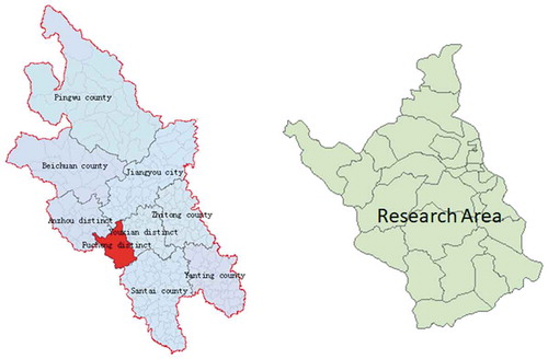
Mianyang City is affiliated to Sichuan Province and located in the northwestern part of the Sichuan Basin. The geographic coordinates are between 30°42′-33°03′N, 103°45′-105°43′E. By 2016, Mianyang City had jurisdiction over three districts, five counties and one county-level city. The total resident population was 4,109,900, with a total area of 20,248.4 square kilometers. The territory is very undulating, high in the northwest and low in the southeast. Mountainous areas account for 61.0%, hilly areas 20.4%, and flat dam areas 18.6%. In 2003, Mianyang City was selected as a national-level garden city and became the first prefecture-level city with the name of national-level garden city in Sichuan Province. Fucheng District is located in the west of Mianyang City and the west bank of the Fujiang River. It is the central and core district of Mianyang City with abundant green landscape resources ().
Figure 1. Research area
Data resource
The data used in this study: (1) The topographic map of the study area is derived from the national vector data (2014) (WGS-84 geographic coordinate system), including information like administrative boundaries and public green space after vectorization processing and spatial correction; (2) The remote sensing image is derived from the geospatial data cloud (http://www.gscloud.cn/), such as the image data of Landsat4-5TM in 2000, 2007, 2008 and Landsat8OLI_TIRS in 2018, resolution 30M×30M.
Research methods
Normalized difference vegetation index
NDVI is a normalized difference vegetation coverage index, which can be used to detect vegetation growth status and vegetation coverage, etc. It is one of the commonly used indicators to monitor green coverage on macro scale. In general, the value of NDVI is between −1 and 1. When the value of NDVI is positive, it means that there is vegetation coverage on the ground, and the NDVI value increases with the increase of coverage; when the value of NDVI is negative, it means that the ground vegetation cover is 0 and the surface is covered by water, snow, ice and other things that are highly reflective to visible light; when the value of NDVI is 0, it means the ground is covered by rock or bare soil; when NIR and R are approximately equal and NVDI is close to 1, the reflectance value to visible light is the lowest and the vegetation coverage is good. The NDVI equation is:
Of which: NIR and R are the reflectance values at the near-infrared and red-band, respectively.
Landscape pattern index
There are various landscape pattern indices in landscape ecology. According to the description objects, the landscape pattern index can be divided into an index describing landscape elements and a pattern index describing landscape levels. Despite different manifestations, many landscape indices have similar meanings (Lixiang, Yang, Yihe, Xiaoming, & Bojie, Citation2008). Based on the relevant research literature, the paper selects the patch pattern indices from three aspects: patch, patch type and landscape feature, including Number of Patches (NP), Class Area (CA), Patch Density (PD), Mean Patch Size (MPS), Largest Patch Index (LPI) and Landscape Shape Index (LSI) to objectively reflect the pattern characteristics of the green space landscape in Fucheng District of Mianyang City ().
Table 1. Selection and implications of landscape pattern index
The research progress
Analysis of vegetation coverage change characteristics
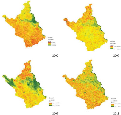
The Normalized Difference Vegetation Index (NDVI) is one of the commonly used indicators for monitoring green coverage. It has been used to study changes in vegetation coverage in recent years. According to the calculation results in , in the past 20 years, the average value of vegetation coverage index in the central district of Mianyang City has increased from 0.129 in 2000 to 0.234 in 2018, with an increase rate of 0.88. From the spatial distribution characteristics of vegetation coverage index, the low value of vegetation coverage index is mainly distributed in built-up urban areas. Secondly, from 2000 to 2007, the area with high vegetation coverage value has migrated to the north side. Due to the 512 Wenchuan Earthquake, the low coverage areas increased in 2009, and the vegetation coverage index increased significantly in 2018, and the balance was improved significantly. However, the south side area was apparently better than the north side area, and the west side area was higher than the east side built-up area. It shows that in the recent 20 years, both the vegetation coverage ratio and overall landscape ecological environment quality have improved significantly.
Figure 2. Vegetation coverage index of Fucheng District from 2000 to 2018
Analysis of patch characteristics of park green space
With the help of NVDI, the paper analyzes the vegetation coverage index of the urban area from macro scale. In order to better understand the landscape pattern of the park green area in the central district, the paper will use the landscape pattern index to quantitatively analyze the landscape pattern of the park green space and further explore the heterogeneity of the landscape pattern of park green space.
Park green space landscape types under city scale
According to the Urban Green Space System Classification Standard (CJJ-T85 2002) and the Mianyang Urban Green Space System Plan (2010–2020) issued by the Housing and Urban-Rural Development Departments, the park green space system of Mianyang City is divided into five categories: municipal parks, district parks, community-level parks, strip parks and street greens. The park green area below 10 square hectares (hm2) is small patch; medium patch between 10 and 30 hm2; large patch between 31 and 50 hm2; and extra large patch above 51 hm2.
From the data shown in , in terms of patch area, the extra large patch area accounts for 40.96%, occupying an important part of the patch area; in terms of patch number, the small patch is still the main part of the urban park green space. The ratio is as high as 52.17%;, and in terms of average patch area, there are significant differences in each type. It shows that the urban park green space patch fragmentation is higher under the city scale, and the park green space landscape is featured by mainly small patches and medium and large patches coexisting.
Table 2. Classification of urban park green space patch size at city scale
Park green space landscape type of Fucheng District
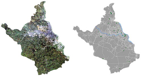
With the help of ENVI software, the 2018 remote sensing images of Fucheng District have been inverted and the patch information of the green space system has been extracted and classified according to the characteristics of the green space landscape. Furthermore by calculating the landscape pattern index of the green space system, the heterogeneity characteristics of the landscape pattern have been analyzed. According to relevant literature research, the small patches refer to areas below 10 square hectares (hm2) in the parks of Fucheng District; the medium patches between 10 and 30 hm2; the large patches between 31 and 50 hm2 Block; extra large patch above 51 hm2 ().
Table 3. Classification of park green space patch size in Fucheng District
From the data display in and , the spatial distribution of the green space landscape types of Fucheng District is very imbalanced. In the aspect of landscape structure, small patches are the main components, and the number of large patches and extra large patches is few and there is a significant difference in the average area and types. The analysis results further indicate that the park green space patch is highly fragmented.
Figure 3. Patch extraction of green space landscape in Fucheng District
Analysis of landscape pattern index of park green space in Fucheng District
Through the above-selected landscape pattern indices, a quantitative analysis was carried out of the landscape pattern of park green space in Fucheng District. From the calculation results in , the small patch density and mean patch area of the green space in the park area of Fucheng District are in clear contrast with other patches, which further indicates that the small patches have a high degree of spatial heterogeneity and the landscape is very fragmented. From the calculation results of the largest patch area index, the values of large patches and extra large patches are big, meaning that large patches and extra large patches have absolute advantages in exerting landscape effects. In terms of patch shape index, the paper uses the square as a reference, and the calculation and analysis tell that the small patch has a large shape index, the medium plaque shape index is somewhere between, and the large and extra large plaque shape index is small, indicating that in terms of the patch shape characteristics, small patch is complicated by shape and highly heterogeneous, which is consistent with the analysis of mean patch area and patch density.
Table 4. Analysis of the patch landscape index of park green space in Fucheng District
In summary, through the calculation and analysis of the landscape pattern index of the park green space in Fucheng District, the small patch has a high degree of spatial heterogeneity and fragmentation, with a big patch shape index, and it is concluded that the small patch is a major component of the green landscape system. Therefore, in the process of optimizing the construction of the park green space system in Fucheng District, it is to optimize the spatial layout of small patches and reduce the degree of fragmentation; meanwhile, to strengthen the construction of large and extra-large park green space is an important way to promote the construction of urban park green space system and improve its service quality.
Conclusions and discussions
With the help of ENVI and ArcMap, the NDVI and the landscape pattern index are used to quantitatively analyze the urban scale and the green space landscape pattern of urban parks in Fucheng District. It is found that:
-
In the past 20 years, Mianyang City has made remarkable achievements in the construction of green space system, and both the vegetation coverage index and the quality of urban greening have been greatly improved. However, according to the calculation and analysis of the landscape pattern index, at present, there are still some problems to be solved such as imbalanced spatial distribution of landscape patches, unreasonable landscape structure and high degree of fragmentation.
-
Through the calculation and analysis of the landscape pattern index of the park green space in Fucheng District, the small patch is spatially heterogeneous and very fragmented with a large patch shape index. Therefore, optimizing the spatial layout of small patches and reducing the degree of fragmentation is the primary task of the construction of park green space system in Fucheng District.
-
Improving the landscape diversity of park green space is an important way to improve the quality of urban greening.
Through data analysis, from the perspective of the city scale and the patch characteristics of the park green space in the district, the major existing problems include high patch fragmentation and bad diversity. Therefore, what needs to be done is to create a diverse landscape space, integrate the existing green space system, reduce the plaque fragmentation, and make full use of its overall benefits.
-
(4)Large and medium-sized parks should be built to give full play to its scale effect and increase the service radius of park green space.
It is also found that large and medium-sized park green spaces possess the greatest advantages in terms of area, regardless of city scale or type of park green space landscape in Fucheng District, but there are only a few in quantity. In terms of scale agglomeration effect, large-scale park green space has an absolute advantage in urban greening system construction and service guarantee for urban residents. Therefore, with the population density, service radius and spatial accessibility fully considered, it is suitable to build large and medium-sized parks in urban built-up areas so as to give full play to its scale effect, improve service radius, and promote the quality of urban park green space and the improvement of human settlements.
Acknowledgments
Research on the influence mechanism of urban river corridor on urban landscape pattern based on complex system theory (51608449)
Disclosure statement
No potential conflict of interest was reported by the authors.
Additional information
Funding
References
- Cao, Y. , Xiao, D. , Zhao, Y. , Li, X. , & Wang, L. (2001). Analysis on landscape ecology literatures in China during recent ten years. Journal of Applied Ecology , 12(3), 474–477.
- Che, S. , & Song, Y. (2002). Analysis of landscape pattern of park system in City of Shanghai. Journal of Shanghai Jiaotong University (Agricultural Science) , 20(4), 322–327.
- Chun, O. , Yao, X. , Ziqian, W. , Sun, Y. , Yang, X. , Kai, M. , & Huang, Y. (2017). The analysis of the green landscape pattern in main urban area of Fuyang City. Journal of Jilin Institute of Chemical Technology , 34(11), 68–72.
- Duning, X. , Yi, Z. , Zhongwei, S. , & Guosu, Z. (1990). Study on the change of landscape pattern in the Western Suburbs of Shenyang. Journal of Applied Ecology , 01, 75–84.
- Feng, S. , & Fan, F. (2018). Spatio temporal changes of landscape pattern using impervious surface in Guangdong-Hong Kong-Macao Greater Bay Area, China. Journal of Applied Ecology , 29(09), 2907–2914. doi:10.13287/j.1001-9332.201809.013
- Forman, R. , Godron, M. , & Xiao, D. (1990). Translated landscape ecology . China: Beijing Science Press.
- Jun, G. , Mingjing, Y. , & Kanghua, T. (2000). Analyse the pattern of urban greenery features in Shanghai. Chinese Landscape Architecture , 01, 53–56.
- Liang, Z. , Hongying, L. , Wentao, L. , & Chunli, Z. (2018). Study on the evaluation and influence factors of cultivated land fragmentation in Lulong county based on landscape pattern. Research of Soil and Water Conservation , 25(06), 265-269+276.
- Lin, Z. , Xinyan, Z. , Tianwei, W. , Zhaoxia, L. , & Chongfa, C. (2018). Spatio-temporal evolution and prediction of urban landscape pattern and habitat quality based on CA-Markov and InVEST models. Journal of Applied Ecology , 29(12), 4106–4118.
- Lixiang, C. , Yang, L. , Yihe, L. , Xiaoming, F. , & Bojie, F. (2008). Landscape pattern analysis in landscape ecology: Current, challenges and future. Acta Ecologica Sinica , 28(11), 5521–5523. doi:10.1016/S1872-2032(09)60011-1
- Mianyang Burea of Urban and Rural Planning . (2014). Mianyang city urban green space system planning. Retrieved from http://www.mygh.gov.cn/data/v/201403/2134.html
- Ou, W. , & Yang, G. (2004). Spatio-temporal variation and driving forces of landscape patterns in the coastal zone of Yancheng, Jiangsu. Scientia Geographica Sinica , 05, 610–615.
- Ren, J. , Liu, H. , Ding, S. , Wang, M. , & Bian, Z. (2017). Landscape pattern change and its driving mechanism in Yihe River Basin, China. Journal of Applied Ecology , 28(08), 2611–2620.
- Yonghui, S. , & Xuegang, M. (2018). Landscape pattern and driving mechanism of a traditional village in South of Henan Province: A case of Dingliwan Village, Xinxian County. Areal Research and Development , 37(03), 172–176.
- Wang, Z. , Wang, Z. , & Bao, Y. (2011). Landscape pattern analysis on the urban green space system of Tongren City based on GIS. Journal of Gansu Agricultural University , 46(01), 110-114+126.
- Wei, X. , & Cai, J. (2018). Analysis and optimization design of green space landscape pattern of Nanchang City Park in GIS. Journal of Applied Ecology , 29(09), 2852–2860. doi:10.13287/j.1001-9332.201809.007
- Yining Gao , Mengli Z. , Mei X. , & Tianqi, Z. (2018). Analysis on the characteristics of grassland landscape pattern and its influencing factors in the farming-pastoral ecotone. Journal of China Agricultural University , 23(10), 103–111.
- Zeming, W. , Wu, W. , Gao, J. , & Zhang, S. (2003). The analysis of urban forest landscape pattern in Hefei. Journal of Applied Ecology , 14(12), 2117–2122.
- Zhu, C.H. , Ya-bing, H.U. , Zhi-peng, Z.H. , Qi-quan, Z.H. , Chen-xi, Q.U. , & Jian-wen, D.O. (2018, November 24). Landscape pattern evolution along terrain gradient in Fuzhou City, Fujian Province, China. Journal of Applied Ecology , 29, 1–13.