
 ?Mathematical formulae have been encoded as MathML and are displayed in this HTML version using MathJax in order to improve their display. Uncheck the box to turn MathJax off. This feature requires Javascript. Click on a formula to zoom.
Abstract
The urban transportation infrastructure (UTI) is an essential asset for any city and it affects citizens, governments, economic growth and urban functioning. The UTI is more valuable than ever due to the urbanization process that concentrates more people in the urban centers, generating a greater mobility demand and urban sprawl that encourages the automobile usage with its associated consequences like congestion, roads accidents, noise etc. Hence, a new UTI management approach is required in order to enhance the sustainable mobility paradigm. The objective of this paper is to construct a set of indicators related to the sustainable transportation modes that could help the decision-making of urban planning via a Geographic Information System. As a case study, the indicators are determined for a Census Tract within Iztapalapa County, the results revealed opportunities for improvement through lines of action that belong to an integral mobility plan rather than partial implemented countermeasures.
Public Interest Statement
Mexico has been transformed from a rural to an urban country. This process implies enormous technical-strategic challenges and demands a new way of urban-transportation planning. This is a difficult task due to the complexity that presents the urban transportation system as a set of geographically distant territories in which locations with different characteristics, needs and priorities are interconnected. In the presentation of mobility’s diagnostics in Mexico City, the Minister of the mobility department (SEMOVI) mentioned that it is essential to implement strategic models of urban development aimed to prioritize the pedestrians, cyclists and users of public transport, and discourage the automobiles usage in order to positively impact the quality of people’s life. This work deals with the creation of a system of indicators related to urban transportation infrastructure-urban surroundings so that to provide mobility and integral accessibility to society within the context of the sustainable mobility paradigm.
1. Introduction
The transportation system and its infrastructure is one of the most pressing problems in cities today. In recent decades, many studies and research has been done trying to find solutions. In general, it has been found that investment in this sector causes a positive economic impact, in particular on growth (Flores, Chatziioannou, Segura, & Hernández, Citation2013, p. 84). In the past two decades, the analytical literature has grown substantially with studies carried out using different approaches, such as a production function (or cost) and growth regressions, as well as different variants of these models (using different data and methodologies). The majority of these studies found that transportation infrastructure has a positive effect on output, productivity, economic and social well-being, the security of people and things as well as growth rate (Calderón & Chong, Citation2009; Calderon & Serven, Citation2008; Estache & Fay, Citation2009; Fan & Zhang, Citation2008; Khandker, Bakht, & Koolwal, Citation2009; Melo, Graham, & Brage-Ardao, Citation2013; Mu & van de Walle, Citation2007; Schofer & Mahmassani, Citation2016; Zhang, Citation2008).
One of the pioneers in this area was Aschauer (Citation1991) who, through his empirical studies, provided substantial evidence in which transportation is an important determinant of economic performance. Another example is the work by Alminas, Vasiliauskas, and Jakubauskas (Citation2009) who concluded that transportation has contributed to growth in the Baltic region. Another research concerning the Spanish plan to extend roads and railroads that connect Spain with other countries deduces that it has a positive impact in terms of Gross Domestic Product (Álvarez-Herranz & Martínez-Ruiz, Citation2012).
Moreover, it needs to be stated that transportation infrastructure is a very important element to consider in order to enforce scenarios related to freight mobility as well as scenarios of land use and transportation (Musolino, Polimeni, & Vitettam, Citation2016; van Wee, Citation2002). Because the existence of certain urban infrastructure (e.g. public transportation stations) in a geographic space with mixed land use is able to promote scenarios related to Transit Oriented Development policies and the existence of urban infrastructure in good conditions provides the necessary interface in order to establish reliable link travel times and enforce policies related to the flow of freight vehicles.
However, in another study of the railroad network in the United States, it is mentioned that many economists believe that the project costs exceed the benefits (Balaker, Citation2006, p. 551).
Furthermore, in the traditional model of cost-benefit assessment the evaluation of the impact of transportation infrastructure on regional development is not included (De Rus, Citation2008, p. 23). In these growth-focused studies, we detect a bias towards the economic impact rather than the social goals, thus, it is important to emphasize the impact of transportation infrastructure on qualitative parameters such as development and not only on quantifiable ones such as growth.
In this paper, we provide grounds on the social (qualitative) aspects of transportation system and specifically of mobility and its implications for the management of urban infrastructure in Mexico City in general and in Iztapalapa in particular.
The sustainable mobility paradigm (Banister, Citation2008; ITDP, Citation2012a) gives emphasis to the sustainable transportation modes such as pedestrians, cyclists and public transport and to the concept of accessibility due to their incapacity to cover long distances. Hence, the actions of urban management need to be reflected upon the elements of UTI and its urban surroundings related to these transportation modes. For that reason, in this paper we focus our efforts on evaluating the quality of mobility in terms of UTI-urban surroundings coverage and functionality at a Census Tract (CT) level.
To achieve this goal, a set of indicators will be proposed that were constructed by resorting to public information available in form of shape files and tabular data coming from various public institutions such as the National Institute of Statistics and Geography (INEGI in Spanish), National Statistical Directory of Economic Units (DENUE), the Ministry of Urban Development and Housing (SEDUVI), the Ministry of Mobility (SEMOVI), the Ministry of Constructions and Services (SOBSE) among others.
2. Qualification methodology of urban transportation infrastructure and its surroundings
In this paper’s section, is explained how the methodology has been developed in order to create the indicators that will permit the evaluation of the actual situation in the CT according to the coverage and functionality of UTI and its urban surroundings.
Nevertheless, before moving to the indicator’s methodology, it is important to explain what the objective of the proposed methodology is and how it can be used for the urban transportation planning and management.
The objective of the methodology is to create a decision-making instrument (through public data usage) in the form of a specific set of indicators that could be used in the future and within the context of a more complete study for the generation of a global-synthesized index that will be able to “guide” government public policies in subjects related to transportation planning and in the management of UTI-urban surroundings. The indicators are designed to help enhancing the sustainable mobility paradigm via the adequate coverage and functionality of the UTI-urban surroundings elements related to pedestrians, cyclists and users of public transport.
Moreover, in this section of the paper is presented the geographic area where the indicators are going to be implemented. The selected geographic area is the Iztapalapa County and was selected for the following reasons (Table ).
Table 1. Justification of the selection of a CT in Iztapalapa County as case study
2.1. Relationship between different geographic entities (blocks and CT)
For each CT that exists in the city there are “m” number of blocks. It is noteworthy that each CT is formed from a distinct number of blocks depending on its size. Moreover, the blocks that are part of a certain CT cannot be part of another CT. With other words there is no block that at the same time belongs to two distinct CT (Figure ).
Figure 1. The relationship between CT and blocks.
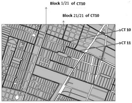
Consequently, if we know the actual situation through certain established indicators at a block level we can produce a synthesized indicator (a global index) at a higher geographic level (CT) that will provide to the public authorities synthesized information about the quality of sustainable mobility in terms of UTI and urban surroundings coverage and functionality. Furthermore, if we have available information at a CT level we can move on to the next geographic level and calculate a synthesized indicator at a county level and so on.
Nevertheless, it is worth mentioning that each block is composed of different fronts. There are regular blocks having 4 straight fronts as there are irregular blocks that can be composed of blunt fronts.
Due to the variety of block’s type and the complexity generated by such fact, INEGI simplified the presentation of information and for each block tells us if all of its fronts have certain infrastructure. If all the fronts have infrastructure it marks it with 1, if some of the fronts have, it qualifies it with 2 and if none of the fronts has infrastructure it marks it with 3. We are going to follow the same technique in order to create the indicators that will permit the evaluation of every block within the examined CT and can be seen in the following section.
2.2. Theoretical construction of the proposed indicators and justification for their selection
The Street lights were selected for the purposes of this study because of their ability to facilitate the mobility in the sense that they provide better security and can reduce crime (Farrington & Welsh, Citation2002, p. 39; Welsh & Farrington, Citation2008).
The merchant stands (semi-fixed post and roadside stands) were selected for their ability to adversely affect the mobility and accessibility of people by reducing the space of sidewalks and causing discomfort among passers-by (Fontán Suárez, Citation2012).
The sidewalks were selected because they are part of the public space especially destined for the circulation and permanence of pedestrians, making them essential to pedestrian mobility which, by law, is at the top of mobility′s hierarchy pyramid in Mexico City (UAM, Citation2013, p. 1).
The ramps were chosen for the importance that present to the mobility of people with different needs (disabled, the elderly, people with strollers etc.) that nowadays becomes critical, since is not only understood as the possibility of movement, but also as the access to opportunities such as employment, health, education etc., in order to reduce social exclusion (Lucas, Citation2010, p. 1).
The sidewalk fittings were selected due to the theoretical framework of road safety audits which highlight them as an important factor for comfort, safety and mobility of people, because not only they minimize the risk of falling but also, provide a certain level of protection against road accidents.
All the above mentioned indicators have the same logic in order to qualify every block, as with value equal to 1 is qualified the block that has UTI elements such as streetlights, ramps, sidewalks, sidewalk fittings and merchant stands) in every front, with value equal to 2 is qualified the block that has UTI elements in some of its fronts and with value equal to 3 is qualified the block that does not have the UTI elements mentioned previously.
The pedestrian bridges were chosen because they allow the permanent separation between vehicle and pedestrian flows; these flows can cross without any interference between them, reducing by that way the risk of accidents (Abojaradeh, Citation2013; García Idárraga & Suárez Idárraga, Citation2002). In that case the qualification logic is different as it is not very common to have blocks that count with pedestrian bridges in every of their fronts. Thus, with value equal to 1 is qualified the block that has pedestrian bridge with accessibility elements (elevators, ramps) in some of its fronts, the block that has pedestrian bridge without accessibility elements is qualified with 2 and the block that does not count with pedestrian bridges is qualified with a value equal to 3.
The road network of motorized transit in accordance with the law of roads and transportation of Mexico City is the physical space exclusively destined for the transportation of vehicles (Gaceta Oficial del Distrito Federal, Citation2002, p. 39), this element of UTI was selected because it connects the city and facilitates the movement of people and goods, it is also the element of UTI which is fundamental to the existence of other associated indicators, such as sidewalks because they are built upon the road network of motorized transit.
For that indicator were selected four types of roads (Table ), these road types are assigned with a level of importance because of their impact on mobility.
Table 2. The hierarchy and characteristics of road types
However, it is difficult to find a block that is surrounded by the same road type, the most common case is the existence of different road types around a block, therefore, a block needs to be qualified in accordance with the existence of different road types to its radius, the interactions between them not only can provide a certain level of territorial displacement but also, alternatives (connectivity) in order for the people to reach their destination. In Table , we see the logic for qualifying each block`s level of connectivity.
Table 3. Block’s qualification with high, medium or low connectivity according to road types
The criterion for the qualification of the block’s connectivity according to the presence of different road types (e.g. I1, I2, I3 and I4) will give preference to the combination of higher hierarchy, which in the case of the previous example would be I1 and I2, qualifying the block with high connectivity.
The coverage of public transport was chosen because of the importance of alternative modes of transport (including public transport) for the reduction of social exclusion (Lucas, Citation2010, p. 1). With a value equal to 1 is qualified the block that has transit of public transport in every front, with value equal to 2 is the block that has transit of public transport in some of its fronts and with value equal to 3 is the block that does not have transit of public transport.
The stations of public transport is an element of UTI that is related to the coverage of public transport, because through the routes we can realize what type of public transport passes by the station and thus, qualify the capacity of service that offers. For example, with high capacity are qualified the large transportation modes like metro and confined- articulated buses, with medium capacity are qualified the buses and trolley-bus and with low capacity are qualified the microbuses and vans. Greater importance (I1) is given to the blocks that contain high-capacity stations, then we have the blocks that contain stations of medium capacity (I2) and finally we have the stations of low capacity (I3). More importance is assigned to the modes of high capacity due to the factor of passenger car unit (PCU) that shows that the congestion phenomenon that adversely affects mobility depends greatly on small vehicles instead of large vehicles that have the capacity to carry a large number of people. Therefore, the modes of high-medium capacity are most preferred if we are to reduce congestion (Esquivel-Fernández, Citation2011; Thomson & Bull, Citation2002, p. 112).
Nevertheless, it is very difficult for every road around a block to have stations of public transport, moreover, it is difficult for a block to have stations of the same capacity, hence, we are going to qualify every block according to the presence of stations of different capacity (Table ).
Table 4. Block’s qualification according to different stations type
The criterion for the qualification of the block in accordance to the presence of different station types (e.g. I1, I2, and I3) will give preference to the combination of a higher hierarchy, which in the case of the previous example would be I1 and I2, qualifying the block with a value of capacity equal to 1.
The population in a block was chosen because of its relation to the demand of mobility since the higher the population within the block, the higher will be the need for displacement (De Rus, Campos, & Nombela, Citation2003, p. 130). We generated four threshold values by following the methodology described in (Palacio Prieto et al., Citation2004), where according to the average values of inhabitants in a certain geographic area (in our case the County of Iztapalapa has an average value of inhabitants per block equal to 138) can be created the following thresholds in order to qualify the blocks within the CT according to the population concentration indicator:
Very High Population Concentration (greater than two times the average) > 276 → value = 1
138 ≤ High population concentration (from the average up to two times) ≤ 276 → value = 2
69 ≤ Medium population concentration (from the average down to half) < 138 → value = 3
Low population concentration (less than half the average value) < 69 → value = 4
The land use indicator was chosen because it can be linked with the demand for mobility in terms of travels generation and the influence of such an indicator to travel behaviour (van Wee, Citation2002). Each type of land use generates distinct patterns of mobility and different structure of travels schedule. For example, a residential land use has a pendulum type mobility, where the pattern of movement is structured in the morning-afternoon and can be located mainly between home and work (Rodrigue, Comtois, & Slack, Citation2013, pp. 206–211).
The qualification of the block according to this indicator will be as follows, with a value equal to 1 the block that has mixed land use, with a value equal to 2 the block that presents housing land use and finally with a value equal to 3 the block that has industrial land use.
The indicator of proximity to the points of interest (POIs) was chosen because it reveals the distance separating the population of a block with nodes that cover human needs. However, first we should define what type of POIs are going to be considered according to the hierarchy of human needs, and then to define what is considered as a short, medium or long distance. So firstly, we use the pyramid of Maslow (Citation1991) in order to define those POIs related to human needs (Figure ).There have been several corrections related to the place where the tables should be appeared within the paper. The above mentioned corrections can be seen via comments written throughout the paper. In relation to the figures captions everything is fine.
Figure 2. Pyramid of Maslow’s human needs in relation to POIs.
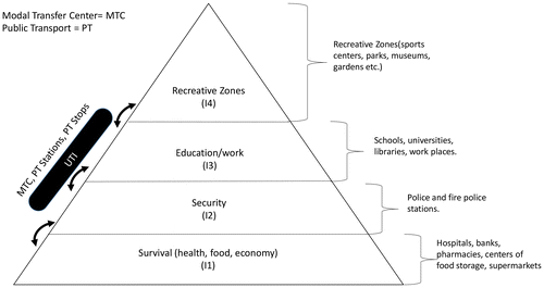
All these needs related to survival are located at the base of the pyramid; the POIs associated to this kind of needs are hospitals, pharmacies, supermarkets, food storage centers, banks, etc.
Since human beings need to feel secure in order to carry out their daily activities, in the pyramid’s second level are located some of the POIs responsible for the security of people, such as fire and police stations.
When human beings have successfully satisfied their basic needs we move to the third level of the pyramid that is the one of the socio-economic needs like work and studies, hence, in this part of the pyramid are located the POIs related to work and studies, such as universities, schools, libraries, work places etc.
As in the previous level of the pyramid, in the fourth one we are still in the domain of socio-economic needs, because human beings as social entities, need to interact with other people, thus, in this part of the pyramid can be found the POIs related to museums, sport centers, parks etc.
The UTI is not specifically located in a certain level of the pyramid but is the interface that connects the different levels of the pyramid between them, generating interactions necessary for the daily life of the people; the POIs related to the UTI are public transportation stops, public transportation stations, and the Modal Transfer Centers.
Using the pyramid of human needs and its relationship with the POIs, we set a hierarchy of them according to their position in the above mentioned pyramid, where of first importance we have the POIs covering basic needs, because without them human beings cannot survive, then there are the POIs that meet socio-economic needs that are necessary for personal development. Finally, there is the UTI that does not belong at a certain level of importance, because it has a transversal character necessary in order the people to cover their human needs by performing everyday activities. For that reason the UTI elements will be considered as POIs of first importance (I1).
Now we need to define what distance is going to be considered as short, medium or long, Garrocho and Flores (Citation2009, p. 257) found that pedestrians are not willing to cover by walking a distance greater than 750 m. A pedestrian can cover a distance of 5 km in an hour (C3 Collaborating for Health, Citation2012, p. 4) therefore, a distance of 750 m can be covered in about 10 min, this time seems an acceptable threshold in order for a person walking to reach its POI, hence, we defined the maximum acceptable distance limit equal to 750 m.
Thus, the indicator of proximity to POIs which is the number of POIs that are within a certain distance of the block’s centroid can be constructed through a GIS via various buffers of influence. The block that has most of its POIs within a short distance (0–250 m) is qualified with 1, the block that has most of its POIs at a medium distance (251–500 m) is qualified with 2 and finally with a value of 3 are qualified the blocks that have the majority of its POIs at a long distance (501–750 m).
The next indicator is the indicator of block’s self-sufficiency according to the presence of POIs around its centroid. This indicator is important because is related to the concept of complete neighborhoods (CTS EMBARQ, Citation2013, p. 17) according to which, the more complete the neighborhood, the more opportunities for the pedestrians and cyclists will be to cover their daily needs without car usage due to the small distance that separates them from the POIs.
The self-sufficiency indicator was generated using the hierarchy of human needs (I1, I2, I3, and I4), the number and type of POIs (the ones defined above through the pyramid of human needs) within an acceptable pedestrian distance of a block. The block that has various types of POIs covering all types of human needs is better qualified as seen in Table .
Table 5. Block’s self-sufficiency qualification as very high, high, medium and low according to the presence of POIs
The bike lanes were chosen because they are the public roads used for the circulation of bicycles (Gaceta oficial del Distrito Federal, Citation2015, p. 7; ITDP, Citation2012b), making them a fundamental part for the establishment of sustainable modes of mobility. The bike lanes can be divided into four types and depending on the existing type of bike lane we can qualify the block, with a value of 1 is qualified the block that has a separate bike lane in one of its fronts, because it is for the exclusive use of bicycles and is physically separated from the motorized transit, then with a value of 2 are qualified the blocks that have in one of their fronts confined or shared bike lanes, the confined bike lanes allow access only to certain points of the bike lanes and are part of the road brook, while the shared bike lanes are those roads that allow interaction between bicycles and motor vehicles (in some cases heavy as trolley-buses). Finally, with a value equal to 3 are qualified the blocks that do not have bike lanes.
Another indicator that could affect the mobility and for that reason has been selected is the block area and form factor which can be expressed via the area/perimeter fraction. Through this indicator, we are able to measure how the block’s size and its perimeter can affect the pedestrian mobility, in the sense that the bigger the size of the block and the more distinct than normal (square) is its form, the greater the distance the people have to walk. We generated four threshold values in order to qualify the blocks by following the same methodology used for the creation of the thresholds values of the population indicator (according to the average values presenting the study area) and are appreciated in the following lines:
Area/Perimeter < 5.5 → value = 1
5.5 ≤ Area/Perimeter < 11 → value = 2
11 ≤ Area/Perimeter ≤ 22 → value = 3
Area/Perimeter > 22 → value = 4
The trees were chosen, even though they have no relationship with the UTI because they can positively affect the mobility of the people making the streets more pleasant by providing facilities for pedestrians and cyclists due to the shadow that they generate protecting the people from weather phenomenon (Fontán Suárez, Citation2012). With a value equal to 1 is qualified the block that has trees in every front, with value equal to 2 is the block that has insufficient trees coverage and with value equal to 3 is the block that does not have trees.
Now that we have theoretically constructed the 17 indicators, it is time to implement them in a CT within the Iztapalapa County via a geotechnology tool such as a GIS, the software that has been used is QGIS because it is license pay free, more specifically is the version 12 of the QGIS project with the code name “Lyon”.
3. Implementation of the indicators in a Census Tract of Iztapalapa
In this section we present through the GIS platform the actual results of the set of indicators for the chosen CT and the interpretation of them within the sustainable mobility framework that gives basis to the following focal points (ITDP, Citation2012a).
| • | The development of neighborhoods that promote walking by giving emphasis to pedestrian safety and convenience. | ||||
| • | The prioritization of bike lane networks, by giving emphasis to cyclist safety and convenience. | ||||
| • | The efficient use of public transport, by matching the population in the area of study with the capacity of the public transportation system mode. | ||||
| • | The promotion of mixed land use near the stations of public transport. | ||||
However, before we pass to the implementation of the indicators within the selected CT it would be convenient to present some of its key characteristics in order for the lector to be more familiarized with its actual features (Table ).
Table 6. Actual features of the selected CT
For economy of space, only the figures that correspond to indicators that have different values for blocks within the CT are included, while figures that refer to indicators with the same value for all blocks are not included.
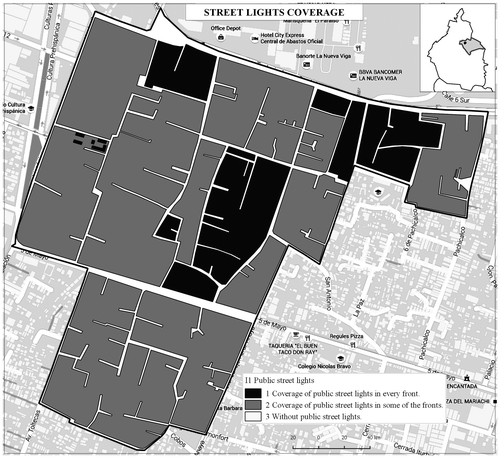
We start the implementation of the indicators through a GIS with the streetlights indicator, as can be seen in Figure , the majority of the blocks does count with sufficient coverage of streetlights. Nevertheless, this can be tricky because within the majority there can be found blocks of small areas, while at the same time there are blocks of very big areas that do not have a 100% coverage of streetlights affecting the security and convenience of the pedestrians. Hence, it is very important for the government to establish a 100% coverage of streetlights within the chosen CT in order to strengthen the new mobility paradigm proposed by SEMOVI.
Figure 3. Street lights coverage.
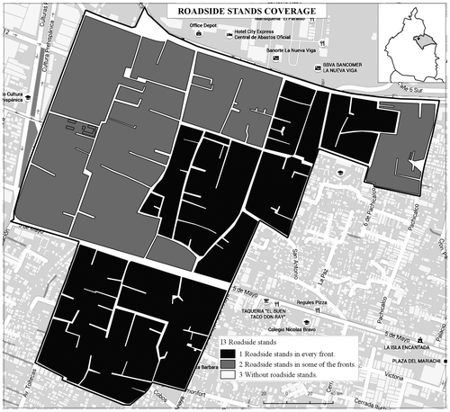
In the following two Figures and we can see the indicators of merchant stands (semi-fixed posts and roadside stands) and it can be said that there are lots of merchant stands in the examined CT. This fact may be good in the sense that offers work opportunities to the people and at the same time offers to the people the opportunity to cover their needs (such as food) without the necessity to use a car. On the other hand, the same posts not only may cause mobility conflicts through the deterioration of certain UTI elements (public streetlights, sidewalk fittings), but also may contribute to the impediment of the function that certain elements of UTI have (sidewalks, ramps, bike lanes). Therefore, what can be done is a series of road safety audits in order to find the hot spots where the merchant stands present obstacles to the pedestrians and cyclists mobility in order to be able to move them to another more suitable place.
Figure 4. Semi-fixed posts coverage.
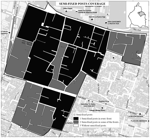
Figure 5. Roadside stands coverage.
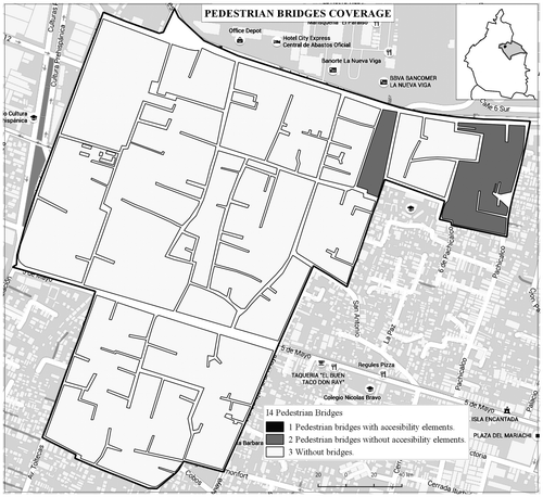
In Figure , is appreciated the pedestrian bridges indicator and we see that only two blocks have in one of their front’s pedestrian bridges (that do not have accessibility elements). The rest of the blocks do not have bridges in any of their fronts, something that is logical because there can’t be bridges in every block. However, what is really important is to strengthen the perception of the people about the security of these bridges, for that reason, it is important to secure the installation of public lights on these bridges. For the rest of the blocks what can be done in order to increase the convenience and security of the pedestrians is to install vertical and horizontal signals avoiding the raised costs that the construction of pedestrian bridges mean.
Figure 6. Pedestrian bridges coverage.
In Figures and can be seen respectively the sidewalks and ramps indicators, which are important elements in order to create complete streets seen as a public space for integration and interaction between vehicles and people, rather than a simple road for the movement of vehicles. Nevertheless, the reality observed does not allow at the moment the creation of complete streets due to the absence of 100% coverage of the above mentioned UTI elements. In the case of sidewalks and sidewalks fittings the actual situation is practically the same as we have a strong majority of blocks having insufficient coverage of the above mentioned indicators, something that needs to be changed because the sidewalks are the primary pedestrian roads and the sidewalk fittings can enhance the security of pedestrian and cyclists mobility.
Figure 7. Sidewalks coverage.
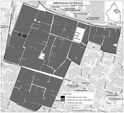
Figure 8. Ramps coverage.
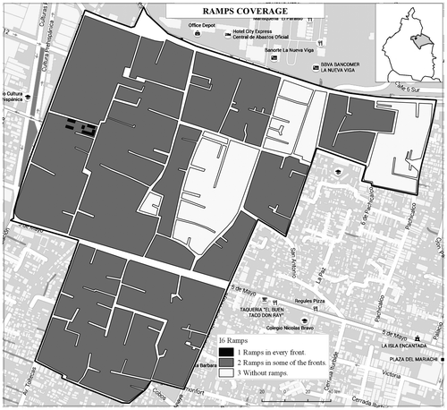
For the case of ramps, the situation is even worse because a big percentage of the block’s total does not count with ramps, something that has to change radically in order to create an inclusive city considering the vulnerable groups and their needs of mobility as a focal point of the population.
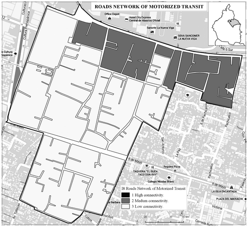
In Figure , we can see the indicator of connectivity according to the existence of different types of roads around of every block’s centroid within the CT, from the north part of the CT passes the principal artery “Trabajadoras Sociales”, there is also a secondary avenue that crosses the CT with the name of “5 de Mayo” which in turn, intersects with another secondary avenue known by the name of “Avenida Toltecas”, the rest of the blocks within the examined CT are crossed by various local roads such as “Pachicalco”, “General Anaya” and “Anillo de Circunvalación”. Due to the existence of this type of roads around the CT, it can be observed that all the blocks in the north of CT that have at least one of their fronts to the principal artery are qualified with a value of medium connectivity, while the rest of the blocks are qualified with low connectivity.
Figure 9. Connectivity indicator.
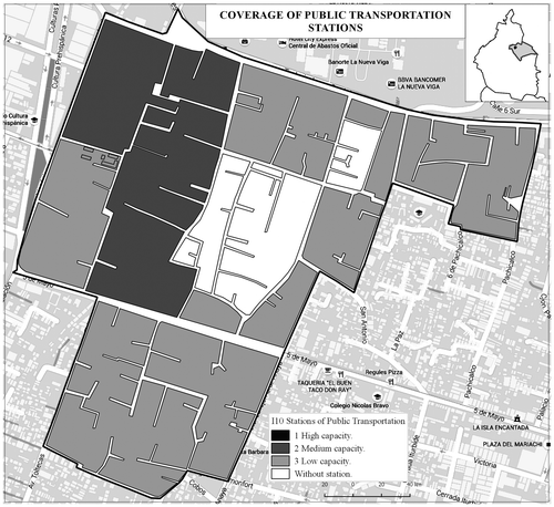
We continue presenting the indicator of public transportation coverage (Figure ) which reveals that we are in a good state, because almost for every block within the CT there is a mode of public transport. Nevertheless, if we compare this outcome with the indicator of public transport stations (Figure ), we see that there are only two blocks counting with stations of public transport of medium capacity (trolley-bus). This fact reveals to us that the rest of public transport flows seen in Figure are modes of low capacity that do not count with public transportation stops, something that is not a favorable factor for sustainable mobility because the transportation modes of low capacity are responsible for congestion, poor air quality, noise and road accidents. Finally, there is a direct relation between the capacity of public transportation modes and the level of connectivity offered by roads, in the sense that the bigger the level of connectivity, the bigger the capacity offered by the public transport modes due to the roads physical characteristics.
Figure 10. Public transportation coverage.
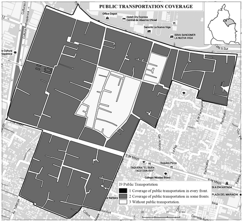
Figure 11. Public transportation stations indicator.
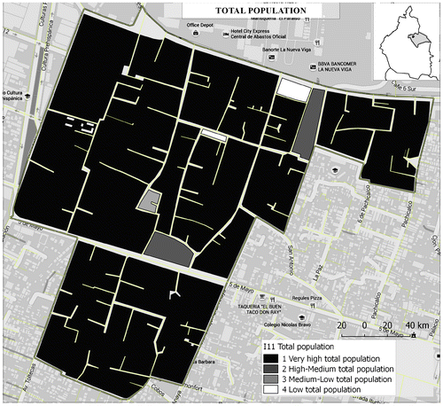
The following two indicators are quite straightforward as they show us the population that lives within each block and the predominant land use type of the blocks within the selected CT. We see that the majority of blocks (65%) have a population greater than 138 people (the average value of population in Iztapalapa), causing a great demand of mobility and consequently a great demand for UTI in good conditions (Figure ). The indicator of land use demonstrates that all the blocks within the limits of CT have, as a dominant land use the housing one, meaning that there is a medium level of demand concerning urban mobility.
Figure 12. Population indicator.
The next two indicators are related to the concept of complete neighborhoods because the first one (proximity to the POIs) demonstrates the facility of people living within the limits of CT to cover their needs without using the car. All the blocks within the CT have a proximity level equal to 3, meaning that the majority of POIs from each block’s centroid is at a maximum distance of 750 meters something that is acceptable because it does not trespass the maximum defined pedestrian distance.
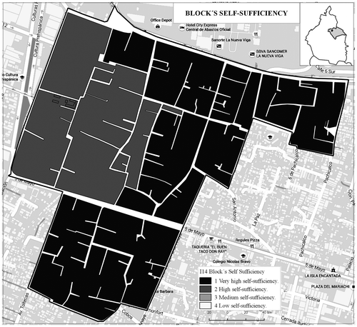
On the other hand, the self-sufficiency indicator demonstrates the types of POIs gathered around each block in order to be able to see what kind of human needs can be covered without using the car. The results were pretty encouraging because in all the blocks within the CT there is a very high-high level of self-sufficiency, meaning that the concept of complete neighborhood can be applied in the examined CT (Figure ).
Figure 13. Self-sufficiency indicator.
Then follows the indicator of bike lanes, that in fact is inexistent, something that is disappointing because the Iztapalapa County is the first County concerning bicycle trips, thus, it is of vital importance to begin constructing bike lanes throughout the central arteries of Iztapalapa in order to cover the needs of cyclists and strengthen the concept of inter-modal transport.
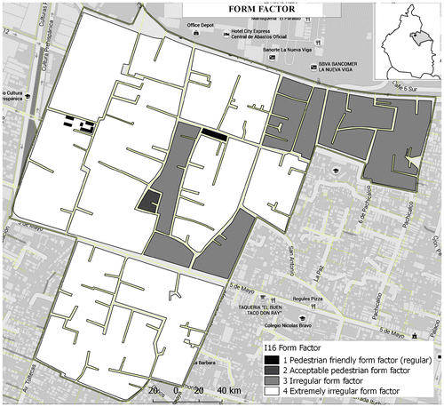
The indicator of block’s size and form factor can be seen in Figure , the majority of blocks contain a very large area, meaning that the people need to walk large distances in order to reach their destination. Moreover, from the same figure we understand that the majority of blocks within the examined CT do not share a normal square form. The blocks do not count with an intelligent planning, they look like labyrinths, causing disorientation to the people that are not familiar with the examined CT. Something that needs to change, if we want to develop neighborhoods that promote walking and high public transport coverage since the more irregular the form of the block the less possible is to pass public transport from it.
Figure 14. Block’s size and form factor.
Finally, we have the trees indicator that shows us that the majority of blocks have trees but not in a 100% coverage (there is no block having trees in every front within the examined CT), something that has to be changed, if we want to establish neighborhoods concerning and promoting the security and convenience of the pedestrians and cyclists.
After the completion of the implementation process, we are able to generate the following Table , where can be appreciated the symbolism of each indicator, the actual values of each one of them as well as the criterions followed in order to result these values.
Table 7. Resume of the actual values of the established indicators in the examined CT
The value of the proposed indicators results from the following mathematic formula:
where Vi is the actual value (V) for each one of the considered indicators (i). Ni is the number of blocks that do count with the desired attribute as it results for each indicator from the criterions established in Table and Ai is the area that these blocks cover. Nt is the total number of blocks within the examined CT and At is the total area of the CT.
Before passing to the conclusions section, it is important to mention that some of the values seen in Table are “absolute,” such as streetlights, merchant stands, sidewalks, sidewalk fittings, ramps, land use, population’s concentration, proximity to POIs, block’s self-sufficiency, bike lanes, trees, size of block and form factor. This qualifier is used because it is desired to obtain values close to one in all of these. In this sense, we are able to conclude if the actual situation is encouraging or not for sustainable mobility.
On the other hand, there are some values concerning certain indicators such as stations and coverage of public transport, pedestrian bridges and road network of motorized transit that are not to be underestimated. This happens because for example, not in every block is possible to have pedestrian bridges or stations of public transport, hence, the values related to these indicators need to be normalized by the government through public policies with respect to a value that represents the desired situation for each one.
4. Conclusions
The objective of this paper has been to assess the actual situation of a CT within the Iztapalapa County in terms of coverage and functionality of its UTI and its urban surroundings related to the sustainable transportation modes. As mentioned before, this study differs from others in the field because it focuses on the social aspects of transportation system through mobility.
However, it needs to be highlighted that this study focuses in defining the UTI and urban surroundings indicators and that is part of a more complete analysis planned for all the CT of Iztapalapa as well as for all the counties of Mexico City in order to promote-establish land-use and transport policies oriented towards sustainable mobility. Nevertheless, the implementation of such a complete analysis has not been completed yet and is future work.
The soundest part of this survey is the theoretical construction of a set of indicators related to sustainable mobility that is demonstrated by their implementation through a GIS platform in the most populated CT of Iztapalapa. By that way, the decision makers are able to realize what the central missing points are in terms of sustainable mobility and what has to be done not only to support the new mobility paradigm in Mexico City, but also to change the urban management approach from a corrective to a proactive one.
It should be mentioned that the sample for the implementation of indicators was small. Nevertheless, they can be applied with success to much larger urban areas with the only constraint the availability of GIS related information, providing elements for local (CT) or area evaluation (counties). Despite the small sample’s size, we were able to explore the topic and draw an initial overview of the missing points related to the new mobility paradigm proposed by the SEMOVI in Mexico City.
Moreover, it is noteworthy that there are other elements of UTI that could surely impact the mobility of cyclists, pedestrians and users of public transport such as (traffic lights, horizontal and vertical road signals etc.). Nevertheless, these elements have not been taken into consideration due to the absence of sufficient information. Efficient ways to complement this set of indicators should be found that can help to assess mobility.
The summary of our findings is very interesting because it shows that the current situation in terms of coverage and functionality of UTI and its urban surroundings in the examined CT needs to be changed. There is insufficient coverage in terms of public lights, sidewalks, ramps, sidewalk fittings, and trees. There are many merchant stands that could potentially cause problems in terms of pedestrian and cyclist mobility; there are no bike lanes within the examined CT, the pedestrian bridges do not count with elements of accessibility. The geometry of the blocks within the examined CT are not the result of an intelligent planning, they don’t have the regular square form, they don’t connect with each other, making them difficult for walking and making them look like labyrinths.
On the other hand, it can be said that in the studied CT there are good conditions in terms of public transportation coverage, proximity to the POIs, level of self-sufficiency and land-use, something that allows the political part of the urban transportation system to promote the necessary counter-measures that needs to be part of an integral plan of mobility, concerning subjects like Transit Oriented Development, the creation of complete neighborhoods, and neighborhoods that in general promote the convenience and security of pedestrians, cyclists and users of public transport.
However, the majority of Mexican cities follow a 3D model (dispersed, distant and disconnected) of urban growth, characterized by a disproportionate, fragmented, and unplanned urban expansion. This model of territorial occupation is highly unproductive, because it deepens the inequality and generates high levels of pollution increasing the risk of climate change. (CTS EMBARQ, Citation2013, p. 31).
Nevertheless, big cities like Mexico City are experiencing and will continue to experience significant growth, so it is very important to be able to deliver the UTI in a successful and sustainable manner. Experience with cases and projects in the past have given us insight into the failures and, according to KPMG (Citation2010, p. 6), these experiences show that we need to take some points into consideration if we want to succeed:
| • | Project environment and turbulence | ||||
| • | Political control and sponsorship | ||||
| • | Role of national government | ||||
| • | Planning effectiveness | ||||
| • | Procurement and financing effectiveness | ||||
| • | Organizing for operations | ||||
The next step to consider is the combination of the above mentioned indicators in order to create a global index that could reveal to the public authorities the quality of urban mobility within the examined CT through the coverage and functionality of UTI-urban surrounding elements by taking into account the perception of the people.
Moreover, it is worth establishing a logical relationship between the above mentioned indicators and public policies concerning sustainable mobility with their corresponding lines of action in order to be able to structure in hierarchical manner different types of strategies according to their effectiveness on the global index.
Funding
The authors received no direct funding for this research.
Acknowledgement
The first author specially acknowledges the support from CONACYT scholarship program.
Additional information
Notes on contributors
Ioannis Chatziioannou
Ioannis Chatziioannou is a PhD student at the systems engineering department of the Posgrado de Ingeniería, Universidad Nacional Autónoma de México. His research areas include urban planning through geotechnology and prospective studies for the enhancement of sustainable mobility paradigm.
Luis Alvarez-Icaza
Luis Alvarez-Icaza is a full-time professor at the Instituto de Ingeniería, Universidad Nacional Autónoma de México. His research interests include model based planning of transportation systems. He has worked in Intelligent Transportation Systems with the application of advanced control techniques to traffic flow control, realistic modeling of traffic with cellular automata and the use of information systems for modeling of a different variety of transportation problems.
The article’s information is important for the urban-transportation planning as it is able to assist the organizational policy-makers to develop neighborhoods that promote walking-cycling and public transport usage in order to encourage the change of people’s movement habits from automobiles towards more sustainable transportation modes.
References
- Abojaradeh, M. (2013). Evaluation of pedestrian bridges and pedestrian safety in Jordan. Civil and Environmental Research, 3, 66–78.
- Alminas, M., Vasiliauskas, A. V., & Jakubauskas, G. (2009). The Impact of transport on the competitiveness of national economy. Department of Transport Management, 24, 93–99.
- Álvarez-Herranz, A., & Martínez-Ruiz, M. P. (2012). Evaluating the economic and regional impact on national transport and infrastructure policies with accessibility variables. Transport, 27, 414–427.10.3846/16484142.2012.753641
- Aschauer, D. A. (1991). Transportation spending and economic growth: The effects of transit and highway expenditures (Report). Washington, DC: American Transit Association.
- Balaker, T. (2006). Do economists reach a conclusion on rail transit? Econ Journal Watch, 3, 551.
- Banister, D. (2008). The sustainable mobility paradigm. Transport Policy, 15, 73–80.10.1016/j.tranpol.2007.10.005
- Calderón, C., & Chong, A. (2009). Labor market institutions and income inequality: An empirical exploration. Public Choice, 138, 65–81.10.1007/s11127-008-9339-1
- Calderon, C., & Serven, L. (2008). Infrastructure and economic development in Sub-Saharan Africa (Working Paper 4712, 1–64). The World Bank Policy Research.10.1596/prwp
- C3 Collaborating for Health. (2012). The benefits of regular walking for health, well-being and the environment. London: Author.
- CTS EMBARQ. (2013). Reforma urbana, 100 ideas para las ciudades de México. México: Author.
- De Rus, G. (2008). The economic effects of high speed rail investment. University of Las Palmas Spain, Discussion Paper, 16, 5–36.
- De Rus, G., Campos, J., & Nombela, G. (2003). Economía de Transporte. Barcelona: Antony Bosch.
- Esquivel-Fernández, W. (2011). Elementos de diseño y planeamiento de intersecciones urbanas. Undergraduate study in order to opt for the title of Civil Engineer, Pontifical Catholic University of Peru.
- Estache, A., & Fay, M. (2009). Current debates on infrastructure policies (Working paper 49). Commission on Growth and Development.
- Fan, S., & Zhang, X. (2008). Public expenditure, growth and poverty reduction in rural Uganda. African Development Review, 20, 466.10.1111/afdr.2008.20.issue-3
- Farrington, D. C., & Welsh, B. P. (2002). Effects of improved street lightning on crime: A systematic review. London: Home office research study development and statistics directorate 251.
- Flores, I., Chatziioannou, I., Segura, E., &, Hernández, S. (2013, September 25–27). Urban transport infrastructure: A state of the art. In Proceedings of the European Modelling and Simulation Symposium (pp. 83–92). Athens.
- Fontán Suárez, S. (2012). Índice de caminabilidad aplicado en la almendra central de Madrid (MSc Diss). Complutense University of Madrid.
- Gaceta Oficial del Distrito Federal. (2002). Ley de Transporte y Vialidad del Distrito Federal. México: Administración Pública de Distrito Federal.
- Gaceta oficial del Distrito Federal. (2015). El nuevo reglamento de tránsito. México: Administración Pública de Distrito Federal.
- García Idárraga, A. J., & Suárez Idárraga, L. M. (2002). Estudio del uso de los puentes peatonales avenida del ferrocarril, avenida 30 de agosto y avenida de las Américas, municipio de Pereira. Undergraduate study in order to opt for the title of roads and transportation specialist, National University of Colombia.
- Garrocho, C., & Flores, Z. (2009). Delimitación del centro tradicional de comercio y servicios de la Zona Metropolitana de Toluca. Papeles de población, 15, 233–274.
- ITDP. (2012a). Planes integrales de movilidad. México: ITDP-México.
- ITDP. (2012b). Guía de estrategias para la reducción del uso del auto en ciudades mexicanas. México: ITDP-México.
- Khandker, S. R., Bakht, Z., & Koolwal, G. B. (2009). The poverty impact of rural roads: Evidence from Bangladesh. Economic Development and Cultural Change, 57, 685–722.10.1086/598765
- KPMG. (2010). International, Success and failure in urban transport infrastructure projects. A study by Glaister, Allport, Brown and Travers KPMG’s Infrastructure Spotlight Report. Liverpool: Author.
- Lucas, K. (2010, January 10–15). The role of transport in the social exclusion of low income populations in South Africa: A scoping study. In Proceedings of Transportation Research Board Annual Meeting. Washington, DC.
- Maslow, A. (1991). Motivación y personalidad. Madrid: Ediciones Díaz De Santos, S.A.
- Melo, P., Graham, D., & Brage-Ardao, R. (2013). The productivity of transport infrastructure investment: A meta-analysis of empirical evidence. Regional Science and Urban Economics, 43, 695–706.10.1016/j.regsciurbeco.2013.05.002
- Mu, R., & van de Walle, D. (2007). Rural roads and poor area development in Vietnam (World Bank Policy Research Working Paper No 4340). Washington, DC: The World Bank.10.1596/prwp
- Palacio Prieto, J. L., Sánchez Salazar, M. T., Casado Izquierdo, J. M., Propin Frejomil, E., Delgado Campos, J., Velázquez Montes, A., … Márquez Huitzil, R. (2004). Indicadores para la caracterización y ordenamiento del territorio. Mexico City: National Autonomous University of México.
- Musolino, G., Polimeni, A., & Vitettam, A. (2016). Freight vehicle routing with reliable link travel times: A method based on network fundamental diagram. Transportation Letters. doi:10.1080/19427867.2016.1241040
- Rodrigue, J. P., Comtois, C., & Slack, B. (2013). The geography of transport systems (3rd ed.). New York, NY: Routledge.
- Schofer, J. L., & Mahmassani, H. S. (Eds.). (2016). Mobility 2050. A Vision for Transportation Infrastructure. Evanston, IL: The Transportation Center, Northwestern University.
- Thomson, I., & Bull, A. (2002). La congestión del tránsito urbano: causas y consecuencias económicas y sociales. revista de la CEPAL, 76, 109–121.
- UAM. (2013). Plan integral de manejo de banquetas en Roma-Condesa, propuesta del plan de manejo integral de banquetas en el polígono Roma-Condesa de los alumnos de la maestría en planeación y políticas metropolitanas de UAM-Azcapotzalco. Mexico City: UAM-Azcapotzalco.
- van Wee, B. (2002). Land use and transport: Research and policy challenges. Journal of Transport Geography, 10, 259–271.10.1016/S0966-6923(02)00041-8
- Welsh, B. P., & Farrington, D. C. (2008). Effects of improved street lightning on crime. Campbell Systematic Reviews, 2008, 13.
- Zhang, X. (2008). Transport infrastructure, spatial spillover and economic growth: Evidence from China. Frontiers of Economics in China, 3, 585–597.10.1007/s11459-008-0029-1