
Abstract
In post-heritage-application times, the protection and development of the ancient towns in the Grand Canal areas have become an upmost priority. The current research is set in Keqiao ancient town. It works through the old map from Qing Dynasty, the maps that were drawn between the 1940s and the 1950s, as well as the electronic map gauged in 2013. Drawing on the quantitative analysis of space syntax, the research concludes that from the Qing Dynasty to date, the area with the highest integrated core area is the so-called “Three-Bridge-Four-Water” area. Using the connectivity value of the transformation proposal and the sample area of Shenjialou, this research confirms that enhancing the connection between the water system and the ancient town space would decrease the highest depth value and increase the integration value of Keqiao ancient town. The aim of this research is to study the feasibility of regenerating the vitality of Keqiao ancient town through refining the relationship between the water network system and the town space.
PUBLIC INTEREST STATEMENT
Long time back, the wise ancient people had found that the Grand Canal was the best way to exchange goods. However, this river transportation is no longer continued nowadays. Moreover, the number of ancient towns is declining due to various social problems as well as changes in transportation.
With the rapid progression and almost violent expansion of cities, permeating and protecting the ancient town well have become imminent. We managed to gather the paperwork from the old map from Qing Dynasty, the maps that were drawn between the 1940s and the 1950s, as well as the electronic map gauged in 2013. Drawing on the analysis of space syntax, this research concludes that from the Qing Dynasty to date, the highest integrated area has never changed. The aim of this research is to study the feasibility of regenerating the vitality of Keqiao ancient town through refining the relationship between the water network system and the town space.
1. Introduction
Five thousand years of agricultural-based civilization as well as the historical relevance of the Grand Canal resulted in intimate relationships between the canal and the development of its adjacent canal towns and villages. Today, Keqiao ancient town has been merged into the city of Shao Xing as the Keqiao district, and this has led to an acceleration of urban integration in the area, which subsequently resulted in negative effects in the region, such as “de-nesting” and “hollow-out”. Therefore, from a strategic point of view, there is a fundamental conflict between rapid urban development and the need for cultural preservation and heritage. Currently, the ancient town is facing a series of predicaments, including lack of maintenance in its buildings and infrastructure, the aging of its population, and so on. The physical space is the very foundation of the everyday living of its dwellers; however, currently, the properties of ancient towns are transforming from a daily living-based space to a place that is more geared toward leisure and tourism, as well as act as a means of safekeeping the culture. Thus, it has become an experience that city-dwellers seek—a dwelling experience that is different from their everyday living.
2. Morphological evolution of the townscape and its vital components
The original site for the establishment of Keqiao town is a place named Chiwu during the three-kingdom period. During the Jin dynasty, the Zhedong canal was excavated; during the Tang dynasty, river passages were built; and later during the Song dynasty, an outpost was set in place. In the twenty-first year of the Qian Long calendar (1756 AD), the “Keqiao inspection station” was established around the Xi Guan embankment of the town, and it used to be an important navy garrison of the Shao Xing region. The troop consisted of 32 archers to fend off bandits. The town was named Ke Zhen during Xuan Tong emperor’s rule, which had then become a place of significance. The geographical location of Keqiao town had made it a prosperous place since its very beginning.
The original basis of the town was formed during the three-kingdom period, as found through the excavation of the Shan Yin long channel. Villages were formed during the Han dynasty, and bazaars were established during the Ming dynasty, which made it a prosperous marketplace. According to historical documents, during the reign of Hong Zhi of the Ming dynasty, market trade had become very popular, and the brewing and silk industries, which developed during that era, with a few hundred years of history as of today, are still popular.
The total area of Keqiao ancient town was 5.5 square kilometers, with a population of 20,000. There were interwoven water networks, which were convenient for transportation, and this enhanced the economic development of the town. Consequently, the featured area of the town was distributed mostly on the upper and lower parts of the Xi Guan embankment located on both sides of the Zhedong canal and on the bay of Yong Feng bridge area on both sides of the Ke River. Such areas developed sophisticated residential-commercial mixed building typologies, such as shops on the lower level and residence on the upper level or shops on the front and residence at the back. The majority of housing units were distributed around the Long She Zui (dragon snake tip) area, located at the intersection of the Ke River and the Si Cha River. The Ke River, the Zhedong canal, and the Ci Cha River together formed the interwoven water network of the town, which comprised the configurational framework of the town’s establishment. It was also the town’s primary mode of communication with the outside world. The frequency of water transportation had activated the spatial vitality of the ancient town, and the frequent economical activities catalyzed the prosperity of the town.
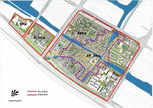
On the eastern side of the current historical cultural district of Keqiao town is the Di Yang road, commercial pedestrian streets, and the Light-textile marketplace, making this side relatively noisy. On its west is a residential area with an urban park 5.1 ha in area. On the south is a highway; a closer inspection shows that it is a historical site within the larger urban context, with its central protection zone being 29.6 ha, and the regulated building area would be 40 ha. The city’s morphology is rather well mixed, consisting of buildings from the Qing dynasty, the Republic period, and from the 1950s, 1960s, 1980s as well as 1990s (Figure ).
Figure 1. Overall layout of Keqiao ancient town. The red frame contains the area of the ancient town where coordinated innovation took place, which is 45.1 ha in total. The purple framed area is the core protection area, and it is around 29.6 ha in size. Source: Qinghua Tongheng Design Institute program, repainted by the author
3. Analysis of Keqiao ancient town’s spatial configuration through articulation of space syntax
3.1. Holistic studies of Keqiao ancient town from the Qing Dynasty to date
Spatial syntax can be used to study the essence of the space itself as an independent element, in combination with a series of mapping techniques. The space can then be subdivided into a series of interrelated diagrams, which will then become a visual tool to represent and re-describe the very typological nature of the space. Using various algorithms, a series of variables (connectivity, control variables, depth, integration, and legibility) related to form and features will be generated, and further studies on these parameters can reveal the relationship among architecture, social context, and human behaviors.
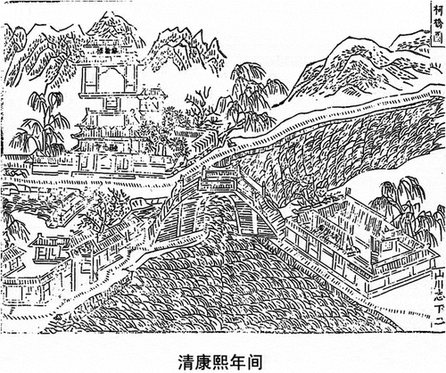
First, using the depth mapping algorithm, the core framework of the space can be represented in only vectors, and by overlaying the analyzed maps of the Keqiao ancient town from both Kangxi and Jiaqing periods, the core sectors of the town can be identified, which are the most integrated (Figure ).
Figure 2. Map of Keqiao ancient town during the Kangxi period in the Qing Dynasty. The picture depicts the landscape of “Three bridges and four water”, which is located in the area where the Zhedong canal intersects the Ke River. One can see that at that time, there were magnificent places like the Cheng Huang Temple, the Rong Guang Temple, and the Cang Jing Archive. Source: Ke Qiao Town Memo; figure retraced manually
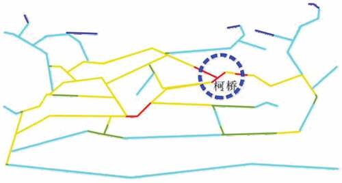
Second, based on the old hand-drawn maps from the 1940s and 1950s, the axial space strategy can be applied. Various measurable elements can be included in the calculation, such as the water network, vehicle roads, and railway on the south. Once the two traffic flows of the outer perimeter are included, one can make observation whether the reading of the most intensified are would shift as a result. This would help gain an insight on whether changes in the external traffic network would have implications on the up-rise or downfall of the ancient town center (Figures and ).
Figure 3. Water network of Shao Xing County during the Jia Qing period in the Qing Dynasty. The blue circle area is the ancient town of Keqiao. It can be seen from the map that Keqiao ancient town is surrounded by rivers and is located in an area that is highly infiltrated by water networks. Sourced from Shao Xing County Memo; image retraced manually
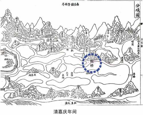
Figure 4. Result of the analysis of the water network map of Shao Xing County using the algorithmic method of spatial axis. The red lines show the part of the ancient town that has the highest integration level. The integration level is displayed by color, with red being the most intense and blue-purple being the least. It can be seen in this canal map of Shao Xing that Keqiao ancient town is located in the most integrated area of Shao Xing County. It also shows that the ancient town had very good accessibility in terms of transportation. Source: drawn by author, and exported)
Third, by conducting further studies on the contour map done by a digital survey in 2013, turning the sophisticated streets in multiple levels into a vectored model, and referring to the directions of pedestrian flow—based on the distances between every midpoint coordinate of each line—combined with the “deflection angle” between different elements, one could determine whether the areas of intensification have currently shifted compared to that of the previous versions since the Qing Dynasty. Currently, the water network in the center of the town no longer operates for transportation purposes. By inserting a deflection angle of 800 m into the equation, and at the same time including the water network as part of the overall town street network system and then running both calculations in terms of depth and integration, one can determine whether the decrease in water commerce has in fact influenced the position and size of the intensified areas.
After overlaid reinterpretation, it is visually quite clear that the area with the highest integration is along the embankment of the Zhedong canal. To confirm whether the change of traffic layout would indeed have an implication on the overall layout and integration of the ancient town, the experiment then considered the contour map of Keqiao drawn in 1949 into the axial space analysis. The Xiaoshao highway and Xiaoyong rail line were built during 1925 and 1937, respectively. Taking both of these factors into account while running the axial analysis, the highest integrated zone is still the area shown in red, which is the place called “Three bridges and four water”, located at the intersection between the Zhedong canal and the Ke River. Hence, when the Xiaoshao and Xiaoyong lines were first drawn, they did not take effect for a long time due to the particular context of history during the period—the traditional water network was still the main “cornerstone” to sustain the economic activities in the ancient town.
After interviewing the local residents as well as making observation of the remaining factory foyer and water tower, it became clear that the gate of foyer opened straight into the river, that every organization had its own motor vessel, and that at that time all the businesses in town still depended on their boats to transport their commodities. During the late 1980s, with the rapid growth of highways, the new mode of transportation became the automobile, which had become extremely efficient compared to the old water networks; thus, the latter were then replaced gradually and eventually ceased to operate. In summary, the change in external traffic condition did not have an immediate impact on the configuration of the town, but the effect had taken place rather progressively, which subsequently led to its economic deterioration. This understanding agrees with the contents of the photographs that were taken during the 1950s and 1960s since the embankments of the Zhedong canal were still visually striking, filled with activity (Figures and ).
Figure 5. Simplified map of the terrain of Keqiao in 1949, which briefly entails the spatial structure of the ancient town of Keqiao in 1949. Source: Keqiao County; image retraced manually
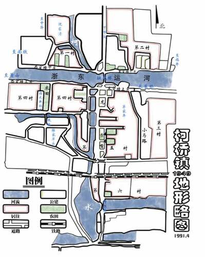
Figure 6. Utilizing the spatial axis method, the difference in the level of integration of the ancient town is revealed. The red lines indicate the area with the highest integration level, and the level decreases accordingly from red, orange, yellow, purple to blue. One can see from the image that the area with the highest amount of activities is located in a place called the “San Qiao Si Shui” (Three water and four cannel). Image source: redrawn by author, and exported
Currently, the Zhedong Grand Canal freight transport has set a new course; the original passage had decreased to level 6, and at the same time, the water quality is being improved. Hence, incorporating it into the overall pedestrian system seems appropriate. The way in which spatial syntax describes a space is mostly based on interchangeability and accessibility—the more integrated the area appears to be, the more accessible it will be, and this fact also provides a very useful guideline for future renovation of the ancient town.
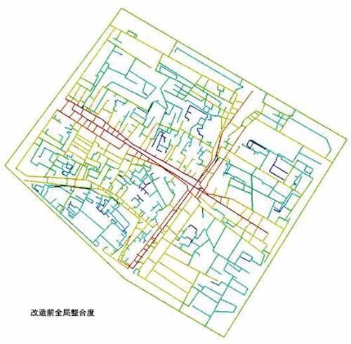
Analyzing the overall layout using the integration space study, every single line represents a space (or a street); after algorithmic calculation, the lines would appear in gradient of color ranging from red-yellow-green up to blue, representing different intensities (or integration levels) of the space varying from high to low. The general tendency is that the integration level would rise toward the center of the town. At the peak of resonance where the area appears in red, it is still the residential commerce area combined with the embankment area of the Zhedong canal and the Ke River.
The sublevel streets and walkways would then radiate and branch off from these two main arteries, but the level of intensity would then decrease as one moves further away from the riverbanks.
Hence, one can conclude that from the Qing dynasty to date, the “Three bridge and four water” is still, and constantly had been, the very central core and also the most vitalized sector of the ancient town. On the diagram, the blue part shows areas that are less integrated (accessible), and they are mostly the private residential areas of the townsfolk (Figure ).
Figure 7. Results of the overall calculation result based on integration-level analysis before the renovation of Keqiao ancient town. The level of integration, again, decreases from red-yellow-purple to blue color. The red area in the map is the “Three bridges and four water”, which is the central core of the town and is formed by the intersection of Zhedong canal and the Ke River. The yellow area has a relatively high degree of integration, which is located in the covered promenade along the Zhedong canal and the “Long she zui” residential area along the Ke River. The purple and blue areas show the places with the maximum depth, as they are located in the streets and courtyards of the ancient towns, so the degree of communication with the outer world is relatively low. Source: drawn by author, and exported
3.2. Overall depth analysis of Keqiao ancient town
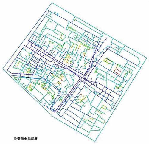
The area with the maximum depth in town is the location shown in red, consisting mainly of endpoints of alleyways, light-wells, and internal courtyards—areas where local residents carry out their daily living activities. Dense and intricate alleyways, resembling wires on an integrated circuit board, interconnecting and subdividing the town into small fragments—with intimate relationship between them however—along with all the tiny passages, would eventually lead to the water canal. This layout strategy is a reflection of the fact that back then, the waterways must have been the source of all daily living activities, including washing, cooking, and sailing.
The depth analysis of the ancient town masterplan before renovation is shown in Figure 8. The purple areas are the spots with the lowest depth. It can be seen that the areas with high levels of integration are very much in alignment with the areas with the lowest depth; thus, the lower the depth, the higher the vitality of the space, and in the case of the Keqiao ancient town, these will be the spaces that are directly related to social and economical productions. The place with the highest amount of depth is the living areas, also relatively lower in the integration level, but they are rather active in terms of social and cultural actions (Figure ).
Figure 8. Overall calculation results of the ancient town, based on depth analysis, before the renovation of Keqiao ancient town. The purple area is the place with the lowest depth level, and the level of depth increases accordingly, with respect to the colors blue, green, and red. The area with a relatively lower depth in the ancient town is still the area where the Zhedong canal intersects with the Ke River streets, whereas the alleyways and courtyards are much higher in depths. Source: Drawn by author, and exported
3.3. Connectivity analysis of Keqiao ancient town before and after renovation
The connectivity value is a local variable; it stands for the amount of possible spatial intersection of any given space—the number “i” space. By feeding this algorithm into the overall system, the higher the connective value that a place acquires, the more porous it would be. The connectivity of Keqiao town before renovation is shown in Figures and , ranging from red-yellow-green to blue, representing the connectivity value of each space ranging from high to low accordingly. The area shown in red is mainly distributed on both sides of the Zhedong canal, the yellow zone is the Ke River and its interconnecting river of Sicha, and the rest of the network branches off from these two main axes. The internal residential space has a rather low connectivity with the outer space, and hence has a very strong sense of enclosure and privacy.
Thus, for the ancient town of Keqiao, its configuration is actually an appropriate result of its “self-evolution” over the years—with the economical and production-related activities focused around the Zhedong canal area, where it is highly connected with the external world, whereas the daily living space remains intimately enclosed. The town became prosperous over the years, indicating that such arrangements must have been a suitable and logical choice for those periods. By comparing the masterplans of before and after renovation, one can see that the intervention has organized and reshaped the dense alleyways of the town. Based on the existing morphologies of the ancient town, areas that were relatively isolated are now better connected, expanding its scope for more spatial interactive engagements (Figures and 1).
Figure 9. Degree of connectivity before the renovation of the ancient town. According to the spatial syntactic axis analysis method, the red and yellow line segments are better connected with the outside world, and the parts in blue are the most isolated. It can be seen from the image that the blue line segments are dense, indicating that the structure of the ancient towns and streets before the renovation is very sophisticated in terms of morphology and its connection with the outside world is poor. Source: drawn by author, and exported
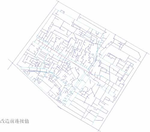
Figure 10. Degree of connectivity after the renovation of the ancient town. Through the spatial syntax axis analysis method, the connection between the areas marked in red and yellow line segments and the outside world was found to have improved significantly. After the transformation, the structure of the street is reorganized. The blue line segments are still dense, but they are much friendlier in terms of path finding; thus, the connection with the outside world is more comfortable. Source: drawn by author, and exported
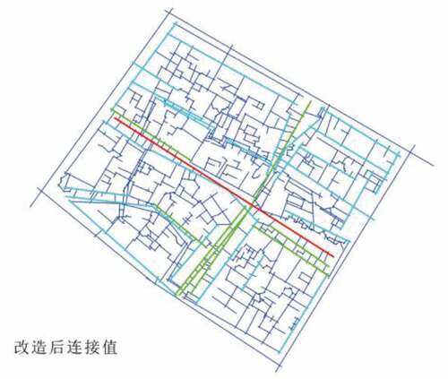
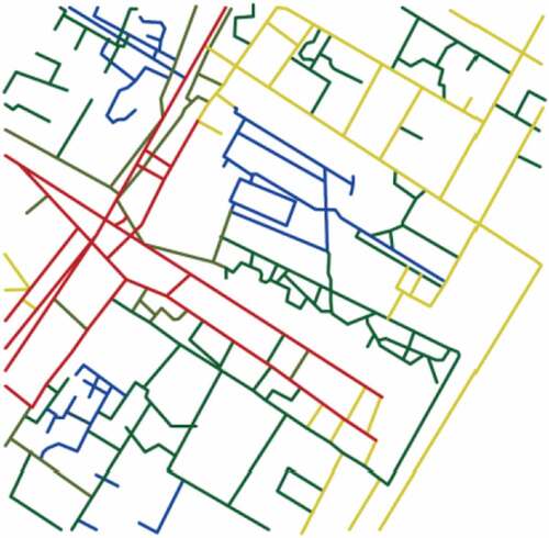
Figure 11. Results of integration and depth calculation before the “Shen Jia Lou” model area is modified. Using line segment analysis in the axial analysis method, with a focus radius of 800 m, it was found that the “Three bridges and four waters” area formed by the Ke River and the Zhedong canal has a much higher integration level and lower depth. However, the integration level of its immediate surroundings reduces rapidly, and peak rapidly in depth, thus the connection of the town with the outside world would be very poor in general. Source: drawn by author, and exported

Figure 12. Results of integration and depth calculation after the transformation of the “Shen Jia Lou” area. Using the line segment analysis in the axial analysis method, and again, with a focus radius of 800 m, it was seen that the modified scheme will open up the water system so the river-flow is no longer contained at the area of “Shen Jia Lou”. It may channel through the ancient town and eventually connect with the Zhedong canal and the Ke River. The overall depth of the transformed area is significantly reduced, and the space had become more accessible and legible. Source: drawn by author, and exported
4. A water-network-based approach to the ancient town of Keqiao
Readings and data gained from various quantitative analyses have proven that the area with the highest level of integration within the whole town had always been the “Three bridges and four water” area from the Qing dynasty to date. The advantages of having a water source nearby along with the covered corridor led to the development of public spaces that were suitable for commercial activities. Currently, the building structures in Keqiao town are facing very serious safety problems due to the lack of maintenance. There is also the issue of the “empty nest phenomenon” as the local population is aging and the younger population is decreasing rapidly; to make matters worse, there is a steadily increasing fluid population, which brings further unstable factors to the urban and living environments. Consequently, the Zhedong canal is gradually losing its identity both as a place of commercial activity and as a place for events (Figures 11 and 12).
This intervention seeks to redefine the canal not only as the “gathering lounge” of the town but also as the safe-keeper of culture. This decision is based on speculative understanding as well as scientific analysis of the spatial syntax, since the water canal is and always has been the highest integrated area in terms of the town’s morphology. It is not erroneous to say that the vitality of this town is triggered by its water source; therefore, renovation should maximize on the protection of, as well as utilizing, its original spatial configuration and ecological conditions to enhance the interaction between our perception and the environment. The renovation scheme will connect the two subordinate rivers so they could both flow into the Ke River and the Zhedong canal, together forming a much more comprehensive water network. Thus, pockets of high integrated areas in the center are now merged into one, subsequently enhancing the connectivity between each individual space, drawing more footfalls into the renovated ancient town, and hence reactivating its public space.
To test whether the design has indeed improved the connectivity of the masterplan, the iconic building “Shen Jia Lou”—enclosed by the Yinfeng Bridge and Ke River—was outlined as a subject of spatial experiment since this is actually the place where the two subordinate rivers connect, which was a major objective of the renovation scheme. A holistic analysis of integration and depth was conducted on the area, and a metric-based radius was used to control the perimeter of interest. Therefore, the studies were performed within a radius of 800 m, and it could be seen that the overall depth of space was reduced significantly after the intervention, which is now much clearer and accessible. Meanwhile, the overall and local integration levels were better too, which would transform it into a dynamic space more suitable for cultural activities and tourism.
5. Conclusion
The spatial analysis of connectivity and depth showed that the area with the lowest depth and the highest integration level is the embankment of the Zhedong canal; this is also the area that is the most accessible when entering from the outside. On the contrary, the spaces with the lowest integration and the highest privacy are the inner courtyards and the endpoints of alleyways in the residential areas, though at the same time they all have easy and relatively direct access to the waterways. Hence, there is a wide range of spatial and sequential combinations regulating and influencing the everyday behavior of the local residents, such as house–river–house, house–covered walkways/town corridors, space–river–street–house, river–house–river, house–street–house, house–space under stilted building–street–river–house, and so on.
Economic production and daily living habits are a reflection of the dynamic and bottom-up self-informed interrelationship between the spatial environment and social actions. The spatial formation of the ancient town was constantly being reshaped because of the interaction between the water network and daily living activities of human beings; this would then in turn reinform growth or even have an impact on the prosperity of the town. Currently, the town needs to be renovated in such a way that it would become an embodiment of culture for the city, leading to the transformation of its dominant space type, from residential to tourism. Thus, from such a standpoint, one should renovate the physical space of the town by retaining the original water and street morphologies and revitalize the town space through trans-programming. It includes the following.
Improving spatial accessibility: The space with the highest integration level, called “Three bridges and four waters” in Keqiao ancient town, led to a wide range of exchange activities and certain behavioral patterns of the townspeople, and the interactive relationship between space and its user, or between the water network and daily events, forms the memories of the local townsfolk. Thus, the first step is to reactivate the water network through spatial intervention by reestablishing water travelling routes, creating more habitable spatial “pockets” near the waterways, and subsequently enhancing the tourist experience of the embankment; hence, multidimensional interaction between the water and street networks must be reconstructed.
Reconfiguration of the water space: Since the water network no longer has any relationship to the local commerce and productive agendas, the design should focus more on how one can improve the spatial quality around and of the water network so visitors may have a unique experience while travelling, such as by dredging the river channel, protecting the existing configuration, creating additional types of riverbank spaces such as sublevel streets, pedestrian trails, and even waterfront plaza. The design should establish and implement a whole new comprehensive system of public space that is completely open to, and is constantly enclosed by, the existing water network so the two may interweave and coexist in a way that is dynamic and vibrant. Moreover, such a design will reduce the overall spatial depth of the ancient town.
Creating a better waterfront experience: There are many architectures of interest in the ancient town, such as the corridor covered by extended/projected eaves, building partly seated on stilts, cantilevering structures, and so on. Some residential housings have staircases leading straight into the canal or have their own mini-river ports. Such unique features have created an advantageous backdrop for the further design and elaboration of near-water public spaces. Taking these existing elements as inspiration, by partially implementing new elements and combining them with the existing ones, the proposed design managed to further enhance the level of engagement between people and the waterscape.
Enhance the diversity of the waterscape: Treating the intersection between the Zhedong canal and the Ke River as the very center of importance, the water network would radiate toward the rest of the town, forming smaller water sub-axes connected to the main source. This would enhance the channeling of water, with diversity in the types of enclosure in various segments of the rivers, which would lead to differentiation in the atmosphere of space around them.
Anti-object on a townscape level: In the design of Villa Savoye, architect Le Corbusier came up with a very intelligent way to tackle the issue of time and space. By containing movement into formally distinctive objects (stairs and ramps) and by placing them in locations that are visible from every corner of the house, the sense of “motion” is constantly felt by the fictive viewer.
If one takes pictures of a conventional building (at that time period), they remain as a series of non-connected pictures. However, if we view the series of pictures in Villa Savoye, one can always use the object of “movement” to reestablish mental connection of the different sequences.
It can be said that the renovation scheme of the ancient town of Keqiao is proposed to have an operation based on its old morphology. Previously, the highly integrated embankment areas and their architectural landmarks were, from an impression point of view, relatively segregated from the neighborhood of the town (areas with the maximum depth). With the renovation in place, the various areas of the town are now much more integrated and better connected to the embankment, and vice versa, where the river would in turn infuse vitality into the town’s alleyways.
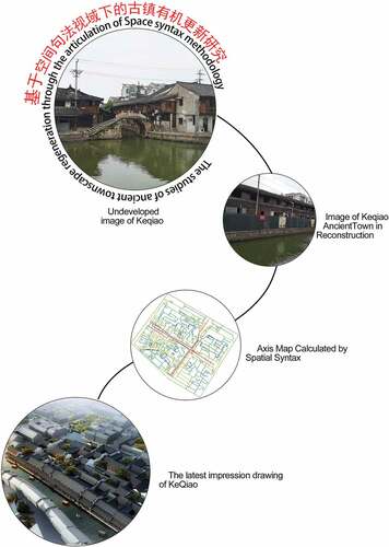
Cover image
Source: Author.
Acknowledgements
The research in this book received full support from the Office of Conservation of Keqiao ancient town, so the writer may acquire much first-hand historical documentation including hand-sketched and electronic maps. Meanwhile, the help from Qinghua Tongheng Urban Design Institute was crucial—the sharing of their renovation proposal and the participation and assistance in the space syntax calculation mentioned in this work are much appreciated.
Additional information
Funding
Notes on contributors
Weilu Lv
The author is an Associate Professor of Zhejiang University City College. In recent years, she has been involved in research of the Grand Canaland inter-related issues, especially the sustainability and protection of the ancient town by the Grand Canal area. She has written works such as “Research on heritage components of Keqiao based heritage route theory” and “Research on reconstruction of the Dynamics of Keqiao based on investigations of public space behavior” and a book named “Ancient town of Zhedong Canal Scattered word cultural heritage”, which is awaiting publication. All these works were supported by the Ministry of Education of the People’s Republic of China’s cultural science and Zhejiang Cultural Science net. Moreover, the Keqiao Ancient Town Protection and Development Committee had invited her to take charge of the environmental facilities design.
References
- Kuma, K. (2008). Anti-object. AA publication.
- Qinghua Tongheng planning institute. (2016). Keqiao historical cultural district conservation and renovation proposal.
- Yong, C., Hong, N. L., Ling, D. X., & Li, L. (2013). The spatial configural analysis of pedestrian space in Jiang Nan ancient town - using Tong Li as example. Architects, 76–14.
- Zhang, X., & Yu, C. Z. (2012). The research of village space transformation based on space syntax - using Lyjiang Shuhe ancient town as example. Urban-town planning. Landscape Design, 09, 106.
- Zhang, X., & Yu, C. Z. (2012). The research of village space transformation based on space syntax - using Lyjiang Shuhe ancient town as example. Urban-town planning. Landscape Design, 09, 107.