
Abstract
Solid waste is one of the leading environmental problems affecting human lives. Selecting a landfill where waste is disposed of is a complicated issue that related to many factors and regulations. In this study, the optimal sanitary landfill site for An-Najaf city was assessed using the GIS and weight criteria method. Eight appropriate criteria were selected, which are: urban area, rivers, roads, soil types, elevation, wind, slope, and archaeological, historical and religious sites. Moreover, the weighting of the criteria by using experts’ opinion and previous similar literature. The “weighted overlay tool” is then applied to get a map of the significance index for selected landfill sites. Seven suitable sites with an area of 177,762,986 m2 and form 0.62% from the total city area can accommodate the solid waste generated for a period, not less than ten years10 years.
Public Interest Statement
In Iraq, there is an apparent problem about environmental pollution (air, water and soil), especially the effect of solid waste on the soil. This paper focuses on sitting sanitary landfill using the GIS tool. At Al-Najaf city/Iraq, there is a considerable amount of solid waste generated daily without any treatment, this paper deal with solid waste generated in order to determine sanitary landfill site according to social and environmental. This study results prove that the GIS technique is a useful tool and can deal with huge data in a rationale manner and can be applied on a different city for the same purpose.
1. Introduction
Since a long time, the early societysociety's concern was the movement of solid wastes out of the generation area. This was significantly probable because human population was moderately low, and the quantities of solid waste produced were somewhat marginal and biodegradable (Fei-Baffoe et al., Citation2014).
The appropriate solid waste management forms a major problem due to increasing human population, variations in lifestyle and habits, increasing disposable revenue, scientific and technological progress and gradually greater generation and new produce consumption. These reasons increase waste generated complexity and amount (Zurbrugg, Citation2002). Municipal solid waste (MSW) management method involves dealing with MSW starting from generation source to its final fate (Oweis & Khera, Citation1990). The actions related withto the MSW management from the generation point to final disposal have been assembled into six functional elements (FE): (1) /waste generation; (2) /Wwaste handling and separation, storage, and processing at the source; (3) /collection; (4) /separation, processing, and transformation of solid wastes; (5) /transfer and transport; and (6) /disposal (Rajaram et al., Citation2016). After all the FE has been assessed for use, and all the crossing pointpoints and relations between elements have been accompanied for usefulness and economy, the community has reached an integrated solid waste management system (ISWM). ISWM can be defined as the choice and use appropriate techniques, programs, and management technologies to attain exact waste management goals and objectives (Tchobanoglous & Kreith, Citation2002). The population growth rate increase, concerns related to public health, and insufficient landfill available land add more problems to the MSW management problem (Kao & Lin, Citation1996). Landfill siting is a very difficult job to be accomplished as the site selection procedure depends on various factors and regulations. The potential landfill sites are identified based on evaluations of geology, hydrogeology, and morphological properties using geographic information system (GIS) techniques (Chang et al., Citation2008; Mansour et al., Citation2014). GIS has been widely used as an integral tool for making the most appropriate decisions on landfill site selection (Al-Mamoori et al., Citation2018a; Rajaram et al., Citation2016; Suresh and Sivasankar, Citation2014).
It is suitable for managing a considerable amount of spatial data from a variety of sources (Siddiqui et al., Citation1996). So it will be ideal for selecting landfill sitesites sincebecause many factors must be incorporated into landfill siting decisions. Therefore, to achieve the research objective, important criteria were considered that influenced the environment and waste management as a dataset for the decision model. Moreover, the AHP is one of the most frequently used multi-criteria decision-making method along with some other techniques (Rezaeisabzevar et al., Citation2020, Monajjem, S. et al. 2015). Different researchers have used variable site selection criteria, mainly since different criteria apply to a different region and different nearby (Al-Ansari, Citation2013). Barakat et al. (Citation2017) study conducted to identify candidate landfill sites using geographic information system (GIS) and multi-criteria evaluation techniques in Béni Mellal-Khouribga Region and the results showed that this study could help planners and local and regional authorities to better manage the solid waste in the region (Barakat et al., Citation2017). Santosh and Sivakumar Babu (Citation2018) assessed groundwater vulnerability to contamination using the standard DRASTIC method. The presented approach assists decision-makers in selecting reliable locations for the safe disposal of MSW Santosh & Sivakumar Babu, Citation2018). In their study, Adewumi et al. (Citation2019) implemented the GIS and the analytic hierarchy process (AHP) to select the most suitable landfill location in Lokoja, Nigeria. The result will greatly serve as a guide in landfill site selection in major urban states of other developing countries (Adewumi et al., Citation2019). Agrawal et al. (Citation2020) carried out a study to select a candidate landfill site for the city of Sultanpur using GIS and AHP. Eight sites have been considered, and landfill suitability indices were calculated for the proposed landfills to facilitate the final site decision (Agrawal et al., Citation2020).
An-Najaf city suffers solid waste accumulation problem in the streets and vacant places between residential areas, and this, in turn, affects the health and safety of citizens. In addition, landfill (sanitary) sites do not comply with environmental determinants, which lead to environmental pollution (air, water, soil).
In this study, an evaluation scheme for identifying the suitable locations for waste landfill site selection An-Najaf governorate is assessed. Geographic Information System (GIS) and multi-criteria decision analysis were implemented, and criteria correspond to scientific and environmental standards had been chosen. The weight of each influencing factor was determined by using expert’s opinions and similar previous literature. Furthermore, the resulted maps can be used to analyze natural and artificial elements that affect the environment during landfill site selection. Data were collected from related directories, then GIS werewas used to produce the maps. After that, ranked models were used to specify the most suitable alternatives and determine each criterion weighting according to the priority of the study objectives. Finally, weightings of sub-criteria based on literature, expert opinion, environmental guidelines, and regulations.
2. Materials
2.1. Study area description
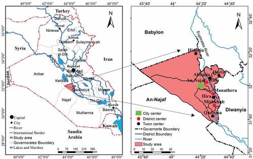
An-Najaf city has an area of (28,824) km2 and forms about (6,6%) of the Iraq area (Al-Mamoori et al., Citation2018b; COOPERATION, Citation2009). About (5%) of the city is located within the alluvial plain, and the rest located within the western plateau (Al-Maliki et al., Citation2018). It consists of three districts and seven sub-districts (The district of the An-Najaf centre, with two sub-districts linked to it, al-Haidariya and al-Shabaka, Al-Kufa district with two sub-districts linked to it: Al-Abbasiya and Al-Hurriya and Al-Manathira district, with three sub-districts: Al-Hirah, Al-Meshkhab and Al-Qadisiyah are linked to it)as) as shown in . The study area is located within the governorates of the Middle Euphrates, as well as not far from Baghdad, which gives importance to its location at the meeting point of different production environments, and this contributed to the activation of commercial movement, exchange and production of goods, also notes its impact on other economic activities (agricultural, industrial and tourism) in the governorate (Al-Mamoori et al., Citation2020). The religious and historical significance of the city has made the governorate an attractive area for residents, whether through housing or the seasons of millions of visits and this causes a continuous increase in the generation of waste.
Figure 1. Location map of the study area
2.2. Daily rate of waste generation in the study area
The population of An-Najaf city was estimated at about (1,193,603) capita for the year 2019, and the amount of waste disposed of per capita is to one (1 kg/day/person). Thus, the amount of waste disposed of is about (1200 tons/day) consist mainly fromof household waste, and according to scientific studies, it has been found that commercial and industrial waste is equivalent to (20%) and (10%) of household waste, respectively. As a result, the total daily waste generated is approximately (1200 tons), monthly (36 thousand tons) and annually (432 thousand tons) (Directorate of An-Najaf city Municipality).
2.3. Sources of solid waste and its collection places at An-Najaf city
Solid waste is one of the most important daily products generated from all types of human activities (domestic, industrial, and commercial) and solid medical waste from government and private hospitals and clinics, in addition to solid waste resulting from construction (Halahla et al., Citation2019), agricultural sites in the studied city. Usually, solid waste is associated with land uses and different activities in the city so, the solid waste generated contains all solid waste types, whether domestic, commercial, agricultural (Fenu & Malloci, Citation2020) or medical (Directorate of An-Najaf city Municipality) as shown in . (Dokić et al., Citation2020)
Table 1. The percentage of solid waste components generated at An-Najaf city
3. Methods
3.1. Methods of collecting and transporting municipal waste
Waste collecting and transporting process was done using small compressors with a capacity (8 m3–16 m3) or pullers each of which includes three people, consisting of a driver and two workers, collect waste from the residential area, and then the compressors and pullers transport the waste to the transfer station, then to the landfill site, due to the lack of waste collection and transportation machines number, some of the waste residues left in the open area. It was noticed during eye viewing that the waste collection process is an incomplete due to the small size of the collection vehicle (8 m3) compared to the size and amount of waste generated, taking into consideration the high residential density and the high per capita share of the generated waste (1–1,250) kg/person/day), thus; thus, there is a permanent deficit in the gathering process. The lack in distributing large capacity containers in the city streets forced the people to throw waste in an empty area or streets or burn it themselves, thus distorting the city’s view through the accumulation of waste in city streets as shown in .
Table 2. Municipal departments and the percentage of deficit in workers and mechanisms
3.2. Transfer stations
The primary need for transfer station is to decrease the transportation waste cost to disposal sites. Consolidating smaller loads from collection vehicles into larger transfer vehicles reduces hauling costs by enabling collection crews to spend less time travelling to and returning from distant disposal sites (Bosompem, Citation2015). There are four transfer stations in An-Najaf city, the main purpose of which is to collect waste since it is no sorting process in this station. It is collected waste until it is transferred to the final landfill site, as shown in and .
Figure 2. Transfer station at An-Najaf city
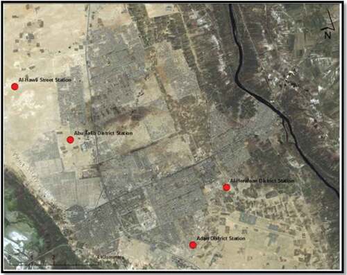
Table 3. Transfer stations at An-Najaf city
3.3. Waste disposal sites
An-Najaf city like most Iraqi cities suffersuffers from the lack of sanitary landfill sites designed according to engineering, and scientific basics, several containers with different sizes are distributed randomly in the city neighbourhoods to collect solid waste (without sorting), after filling, vehicles collect them and then transfer it to the intermediate stations. It was transported and put on in landfill in an open manner, not taken into consideration environmental impacts on the environment and public health. Yet there are two non-engineered landfill sites for dumping MSW in An-Najaf city, as shown in . Landfill Site one1 is in (Uyun Al-Shujaj), 19 acres, form Bahr An-Najaf depression, 20.3 km from the boundaries of the Najaf city master plan, 21.3 km from the boundaries of Najaf municipality, 600 m from the middle Najaf-Rahba road and 5 km from Mazloum Residential Complex. Landfill Site 2 –, it is located adjacent to Site 1 with an area equal to 160 acres, has approximately the same dimensions mentioned for Site 1 on the boundaries of the Najaf master plan, the boundaries of the municipality of Najaf, Najaf-Rahba road, and Mazloum Residential Complex. But with modification of the city master plan, it became close to its borders. The site does not include any archaeological sites and natural reserves, include empty and open land with the not determined area (not separated) and not fenced off. It is formed from old quarries and ground depressions, waste throwing on it without any treatment, and after filling, the bulldozers cover that waste with soil or sand. Despite the presence of working mechanisms at the site, the waste is randomly scattered at the landfill site, and this is disagreeing with environmental standards for sanitary landfill sites, as in . In addition to the presence of scavengers whom they pick up the waste and collect plastic, aluminium, glass containers and dishes.
Figure 3. Landfill sites in An-Najaf city
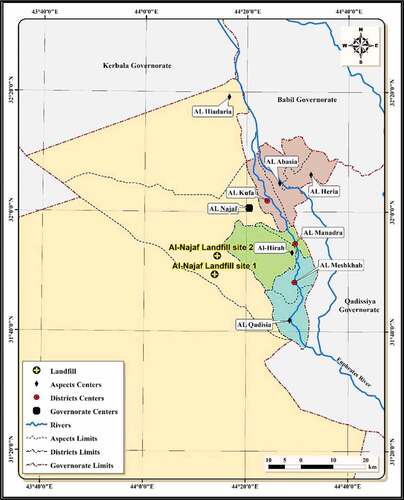
Table 4. The existed landfill sites’ coordinates
3.4. Site selection of sanitary landfills
Wastes that cannot be processed together with the residues need to be safely disposed of. The long-term options of wasteswaste disposal include disposal on land, disposal deep below the earth surface and disposal in ocean bottoms. Land disposal is the most widely used practice all over the world (Ramachandra, Citation2006).
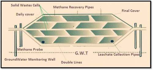
However, dumping of solid wastes on land has serious environmental impacts. Most important, the leachate through the waste infiltrates the soil contaminating groundwater (Chronicle, 9 Jan, Citation2012; Al-Mamoori, Citation2017, AL-Mamoori and Al-Maliki, Citation2016). Frequent outbreaks of water-borne diseases, especially during the rainy season, have been reported in developing countries. Solid waste disposal should be carried out in a suitably designed landfill using engineered landfill designed on scientific principles to protect the environment and public health landfill site selection based on the landfill design. There are two chief kinds of landfill design: Sanitary landfills and Natural attenuation landfills. The key variance concerning these two kinds is the generated leachate control. A sanitary landfill needs artificial liners towards control the release of leachate, as shown in , whereas a natural weakening landfill uses the nearby environmental characteristics to decompose released fluids(fluids (Al-Ameen & Al-Hamdany, Citation2018). Many landfills are designed for 10– to 30 years lifetime and still need post-closure monitoring up to 30 years to ensure the environmental health and surface settlement (Rajaram et al., Citation2016).
Figure 4. Design of sanitary landfills (Tchobanoglous et al., Citation1993)
3.4.1. The factors scheme for landfill siting
Outline for “decision-making” was built on expert interpretations in multi-criteria analysis, previous research, and obtainable data in the study area (Alkaradaghi et al., Citation2019). The site selection ranked scheme includes three levels, as shown in . The first level in the suggested model involveinvolves possible landfill site affecting factors, which involves two groups: natural and artificial environmental factors. The second level has seven primary criteria: aspect, land, geology, hydrological, topographical, social-cultural factors, and accessibility. The third level contains all eight criteria applied in the current research to find appropriate sites as the ideal solution for disposal of solid waste. The ranked outline for “decision-making” was built on expert opinions in multi-criteria analysis, previous research, and available data in the study area (Alkaradaghi et al., Citation2019).
Figure 5. Ranked scheme for landfill site selection decision process
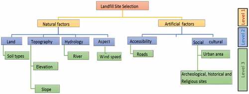
For the eight criteria mentioned above, eight digital maps were prepared as separate information layers. The sites that score 0 ranks are the restricted sites that refer to areas that landfilllandfills must not be located because of their possible negative hazard to the humans’ health, environment, or the high cost (Chabuk et al., Citation2017). The special extension tool “buffer” in the GIS was used to create spatial constraints, or buffer zones around important sites in each criterion (Al-Anbari et al., Citation2018). Moreover, based on the experts’ opinion and the literature in this field, each criterion was classified into sub-criteria. Also, each class was given a rank value according to the criteria important to the study area. Rating values and sub-criteria buffer zone for the input layer are illustrated in . The preference (importance) for each individual criterion to the rest criteria on landfill site selection defined as assigning weights as shown in , depending on a similar previous study (Al-Anbari et al., Citation2018).
Table 5. Layers buffer zone with sub-criteria ratings
Table 6. Criteria weights (Alkhuzaie & Janna, Citation2018)
Soil groups defined above involve: brown soil (SBS) (medium and shallow phase) over “Bakhtiariyary gravel,” chestnut Soil(soil (SCS) (deep phase), rough broken soil (SRB)(stony land),and), and rough mountainous (SRM) (Lland). (Alkaradaghi et al., Citation2019). The final map results from using the layering process “superposition procedure” agreeing with criteria and sub-criteria involved above. This process makemakes the comparision in the study area possible, since it utilizeutilizes different characteristics using GIS (El Maguiri et al., Citation2016). In this study, a more preciselyprecise method by GIS software was used. “Weighted overlay” refers to one of the most tooltools used for overlay analysis to solve multi-criteria problems such as suitability models and site selection (Alkhuzaie & Janna, Citation2018).
4. Results and discussion
GIS was used to prepare the maps in for Each one of the eight criteria depended on identifying landfill site suitability.
Figure 6. An-Najaf city classes map
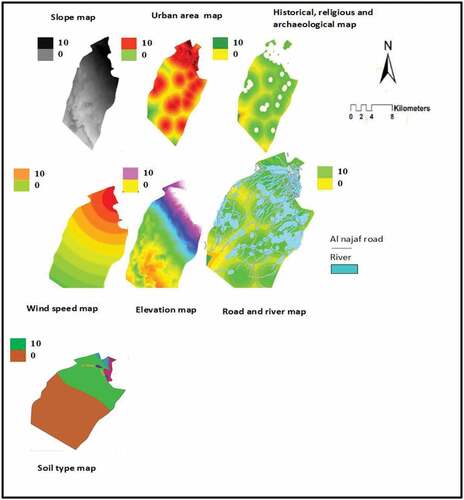
The “river” criterion is necessary to avoid surface water pollution from different types of pollutants (physical, chemical and biological) contained in landfill leachate which may reach the river. Distances from “roads” must be taken into accounts to easing solid waste vehicle transport. As a result, time reduces and accessibility to a landfill site should be achivedachieved to protect the thethe regional aesthetics and not adversely affected. “Topography (elevation)” criteria waswere adopted to avoid flooding risk. Steep “slopes” usually making waste transport difficult and cause water bodieswaterbodies contamination due to leachate drainage, while flat slopes may affect runoff drainage. “Urban area” criterion referrefers to the suitable distance of landfill sites from urban area and potential future expansion must be ensuringensured, and this dependsdepends on different factors like governmental regulations and scientistsscientist environment suggestions. The “soil” criterion was important to avoid soil pollution by leachate movement through soil layers. The “archaeological” criterion meanmeans national cultural heritage, which comprises various archaeological and historical sites, and in this study, religious sites were added to this class” (Alkaradaghi et al., Citation2019).
Then, the “weighted overlay” tool wasutilized in combining each criterion effect into a single map. This involved the assigning of weights/scale values to each criterion and its respective influence in the overall suitability model, and as a result, seven landfill sites had been obtained with different weightweights as shown in . shows the landfill sites obtained information. With the aim of confirming specific areas’ suitability, area inspection must be followed by sites visiting, the optimum sites should be selected based on land ownership, administrative and political issues. It’sIt is found that Site 1 represents the most appropriate, while Site 7 represents the least suitable site. If Site 1 cannot be executed, it can be replaced by Site 2, which is next in the degree of convenience. Thus, Sites (1 and 2) are considered to have very high suitability scores. The suitability scores gradually decrease.
Figure 7. Suitability index map

Figure 8. Candidate landfill sites
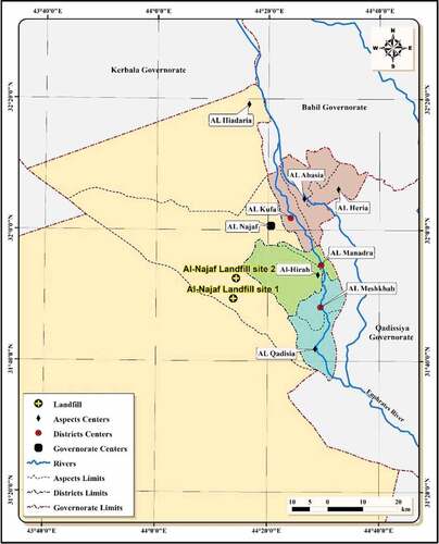
Table 7. The best suggested sanitary landfill sites information at An-Najaf city
5. Conclusion
The current solid waste disposal sites at Al-Najaf Governorate waswere not designed on environmental and sciencescientific issues. Multiple criteria methodmethods and GIS were used to get the optimum solid waste landfill sites. Through the analysis procedures, seven layers that have an effect on the landfillslandfill selection sites were prepared using the GIS software. Utilizing the weighted overlay tool in the GIS software with the criteria weight had a pronounced impact of easing maps algebraic multiplication with minimum errors, and this is better than using manual methods. The selected sites were characterized as the most suitable landfill sites between different locations in each area within An-Najaf city. They can serve the population for a period of not less than ten years10 years.
Nomenclature
| MSW | = | Municipal solid waste |
| SCS | = | Chestnut Soil, Deep phase |
| FE | = | Functional elements |
| SRB | = | Rough Broken and Stony Land |
| ISWM | = | integrated solid waste management system |
| SBS | = | Brown Soil, Medium Phase and Shallow Phase |
| SRM | = | Rough Mountainous Land. |
Additional information
Funding
Notes on contributors

Sohaib K. Al-Mamoori
Sabreen L. Kareem is a civil engineer and holds a PhD in Environmental Engineering from the University of Baghdad. She works as a lecturer at the University of Kufa/College of Physical Planning/Environmental Planning Department. Her precise Specialization is water and wastewater treatment and Management.
She had published many papers about wastewater treatment using nanotechnology, risk assessment, Environmental Impact Assessment, and medical solid waste.
References
- Adewumi, J. R., Ejeh, O. J., Lasisi, K. H., & Ajibade, F. O. (2019). A GIS–AHP-based approach in siting MSW landfills in Lokoja, Nigeria. SN Applied Sciences, 1(12), 1528. https://doi.org/10.1007/s42452-019-1500-6
- Agrawal, R., Srivastava, A. K., & Nigam, A. K. (2020). Landfill site selection in India using analytic hierarchy and geographic information. Proceedings of the Institution of Civil Engineers - Waste and Resource Management, 173(1), 6–17. https://doi.org/10.1680/jwarm.18.00026
- Al-Ameen, J. A. A., & Al-Hamdany, M. A. (2018). Babylon governorate municipal solid waste generation rate. Journal of Engineering, 24(9), 64–77. https://doi.org/10.31026/j.eng.2018.09.05
- Al-Anbari, M. A., Thameer, M., & Al-Ansari, N. (2018). Landfill site selection by weighted overlay technique: Case study of Al-Kufa, Iraq. Sustainability, 10(4), 1–11. https://doi.org/10.3390/su10040999www
- AL-ANSARI, N. (2013). Locating landfills in arid environment. Journal of Earth Sciences and Geotechnical Engineering, 3, 11–24.
- Alkaradaghi, K., Ali, S. S., Al-Ansari, N., Laue, J., & Chabuk, A. (2019). Landfill site selection using MCDM methods and GIS in the sulaimaniyahSulaymaniyah governorate, Iraq. Sustainability, 11(17), 1–22. https://doi.org/10.3390/su11174530www
- Alkhuzaie, M. M., & Janna, H. (2018). Optimum location for landfills sites based on GIS modeling for Al-Diwaniyah city, Iraq. International Journal of Civil Engineering and Technology, 9, 941–951.
- Al-Maliki, L. A. J., Al-Mamoori, S. K., El-Tawel, K., Hussain, H. M., Al-Ansari, N., & Jawad Al Ali, M. (2018). Bearing capacity map for An-Najaf and Kufa cities using GIS. Engineering, 10(05), 262–269. https://doi.org/10.4236/eng.2018.105018
- Al-Mamoori, S. K. (2017). Gypsum content horizontal and vertical distribution of An-Najaf and Al-Kufa cities’ soil by using GIS. Basra Journal of Engineering Sciences, 17(1), 48–60. https://doi.org/10.33971/bjes.17.1.7
- Al-Mamoori, S. K., & Al-Maliki, L. A. (2016). Evaluation of suitability of drainage water of Al-Hussainia sector (KUT IRAQ) to irrigate cotton crop. Kufa Journal of Engineering, 7, 67–78.
- Al-Mamoori, S. K., Al-Maliki, L. A., Hussain, H. M., & Al-Ali, M. J. (2018a). Distribution of sulfate content and organic matter in An-Najaf and Al-Kufa cities’soilcities soil using GIS. Kufa Journal of Engineering, 9(3), 92–111. https://doi.org/10.30572/2018/kje/090308
- Al-Mamoori, S. K., Al-Maliki, L. A. J., Al-Sulttani, A. H., El-Tawil, K., Hussain, H. M., & Al-Ansari, N. (2020). Horizontal and vertical geotechnical variations of soils according to USCS classification for the city of An-Najaf, Iraq using GIS. Geotechnical and Geological Engineering, 38(2), 1919–1938. https://doi.org/10.1007/s10706-019-01139-x
- Al-Mamoori, S. K., Al-Maliki, L. A. J., El-Tawel, K., Hussain, H. M., Al-Ansari, N., & Al Ali, M. J. (2018b). Chloride, calcium carbonate and total soluble salts contents distribution for An-Najaf and Al-Kufa cities’ soil by using GIS. Geotechnical and Geological Engineering, 37, 1–19.
- Barakat, A., Hilali, A., Baghdadi, M. E., & Touhami, F. (2017). Landfill site selection with GIS-based multi-criteria evaluation technique. A case study in Béni Mellal-Khouribga Region, Morocco. Environmental Earth Sciences, 76(12), 12. https://doi.org/10.1007/s12665-017-6757-8
- Bosompem, C. (2015). Multi-criteria selection of waste transfer stations in the Kumasi metropolis.
- Chabuk, A. J., Al-Ansari, N., Hussain, H. M., Knutsson, S., & Pusch, R. (2017). GIS-based assessment of combined AHP and SAW methods for selecting suitable sites for landfill in Al-Musayiab Qadhaa, Babylon, Iraq. Environmental Earth Sciences, 76(5). https://doi.org/10.1007/s12665-017-6524-x
- Chang, N.-B., Parvathinathan, G., & Breeden, J. B. (2008). Combining GIS with fuzzy multi-criteria decision-making for landfill siting in a fast-growing urban region. Journal of Environmental Management, 87(1), 139–153. https://doi.org/10.1016/j.jenvman.2007.01.011
- Chronicle, I. (2012, January 9). Iraqi chronicle. Ministry of Justice.
- COOPERATION, M. O. P. A. D. (2009). Central organization for statistics and information technology.
- Dokić, D., Gavran, M., Gregić, M., & Gantner, V. (2020). The impact of trade balance of agri-food products on the state’s ability to withstand the crisis. HighTech and Innovation Journal, 1(3), 107–111. https://doi.org/10.28991/HIJ-2020-01-03-02
- El Maguiri, A., Kissi, B., Idrissi, L., & Souabi, S. (2016). Landfill site selection using GIS, remote sensing and multi-criteria decision analysis: Case of the city of Mohammedia, Morocco. Bulletin of Engineering Geology and the Environment, 75(3), 1301–1309. https://doi.org/10.1007/s10064-016-0889-z
- Fei-Baffoe, B., Nyankson, E. A., & Gorkeh-Miah, J. (2014). Municipal solid waste management in Sekondi-Takoradi metropolis, Ghana. Journal of Waste Management, 2014, 1–9. https://doi.org/10.1155/2014/823752
- Fenu, G., & Malloci, F. M. (2020). DSS LANDS: A decision support system for agriculture in Sardinia. HighTech and Innovation Journal, 1(3), 129–135. https://doi.org/10.28991/HIJ-2020-01-03-05
- Halahla, A. M., Akhtar, M., & Almasri, A. H. (2019). Utilization of demolished waste as coarse aggregate in concrete. Civil Engineering Journal, 5(3), 540–551. 10.28991/cej-2019-03091266
- Kao, -J.-J., & Lin, H.-Y. (1996). Multifactor spatial analysis for landfill siting. Journal of Environmental Engineering, 122(10), 902–908. https://doi.org/10.1061/(ASCE)0733-9372(1996)122:10(902)
- Mansour, D., El Hmaidi, A., Essahlaoui, A., El Ouali, A., Bouabid, R., & El Abassi, M. (2014, April). Using GIS for selection of potential waste disposal sites in Meknes city. International Journal of Engineering Research and Development, 10(4), 07–19. e- 2278-067X, p- 2278-800X.
- Monajjem, S., Mahanpoor, M., & Sadathoseini, M. (2015). Site locating for inspection posts of freight cars in railway network using Analytical Hierarchy Process (AHP) and Geographic Information System (GIS) (Case study: Iranian railway network).Civil. Engineering Journal, 1, 9–18. https://doi.org/10.28991/cej-2015-00000002
- Oweis, I. S., & Khera, R. P. (1990). Geotechnology of waste management. PWS Publishing.
- Rajaram, V., Siddiqui, F. Z., Agrawal, S., & Khan, M. E. (2016). Solid and liquid waste management waste to wealth: Solid and liquid waste management waste to wealth. Prentice Hall India Pvt., Limited.
- Ramachandra, T. (2006). Management of municipal solid waste. The Energy and Resources Institute (TERI).
- Rezaeisabzevar, Y., Bazargan, A., & Zohourian, B. (2020). Landfill site selection using multi criteria decision making: Focus on influential factors for comparing locations. Journal of Environmental Sciences, 93, 170–184. https://doi.org/10.1016/j.jes.2020.02.030
- Santosh, L. G., & Sivakumar Babu, G. L. (2018). Landfill site selection based on reliability concepts using the DRASTIC method and AHP integrated with GIS – A case study of Bengaluru city, India. Georisk: Assessment and Management of Risk for Engineered Systems and Geohazards, 12(3), 234–252. https://doi.org/10.1080/17499518.2018.1434548
- Siddiqui, M. Z., Everett, J. W., & Vieux, B. E. (1996). Landfill siting using geographic information systems: A demonstration. Journal of Environmental Engineering, 122(6), 515–523. https://doi.org/10.1061/(ASCE)0733-9372(1996)122:6(515)
- Suresh, B., & Sivasankar, S. (2014). Identification of suitable site for urban solid waste disposal using GIS and remote sensing techniques. A case study of Virudhunagar municipality, India. International Journal of Geomatics and Geosciences, 5 (2), 320–331.
- Tchobanoglous, G., & Kreith, F. (2002). Handbook of solid waste management. Mcgraw-hill.
- Tchobanoglous, G., Theisen, H., & Vigil, S. (1993). Integrated solid waste management: Engineering principles and management lssuesissues. McGraw-Hill.
- Zurbrugg, ca. 2002. Urban solid waste management in low-income countries of Asia how to cope with the garbage crisis. Presented for: Scientific committee on problems of the environment (SCOPE) urban solid waste management review session (pp. 1–13), Durban, South Africa.