
Abstract
Change is considered a prominent feature of urban areas because of the various services and functions in cities, with complex functional relations. The study aims to build an informational foundation for urban planners and designers on the effects resulting from the imbalance in the organization and proportions of urban land uses, which in turn affects the performance of its functions in the city and its changes, and thus the necessity of using modern technologies to identify and define urban problems in cities, especially those related to land uses. An analytical approach to the research was taken, adopting geographic information systems as a tool for research by studying the reality of the region and determining the changes occurring from the functional side for the periods of 2,003,200,820,132,018. These periods witnessed substantial development and changes at the city and country levels. Through the results of the study, the changes were identified, remedies suggested, positive aspects were strengthened, and negative phenomena were reduced. The conclusions reached by the study indicate that planning for the use of the land is a very important practical aspect of achieving the needs of the population and limiting the noncultural aspects of expansion. Deliberate and planned change can generate positive results and vice versa.
PUBLIC INTEREST STATEMENT
The main objective of the research is to provide a framework of knowledge about the level that changes in urban land use can reach in the city of Kufa and what types of these changes, their effects and results, and the disclosure of the reasons behind their occurrence, to enhance the positive ones or limit the negative part.
1. Introduction
In 2003, Iraqi cities were subjected to excesses in land use, irregular expansions, modifications of buildings, and diversions of jobs due to unplanned and unorganized growth and change. The change may be based on disciplined and regular foundations that confirm a natural state. Irregular planning has adverse effects that distort the balanced pattern of land uses and confuse city functions. Kufa city in Najaf is an example of this situation. Kufa is a holy city revered for its ancient history and rich cultural heritage. This study chose to focus on the area that falls within the boundaries of the basic plan of Kufa city, and what happened in terms of legal and illegal changes to the basic plan of the city and digital techniques relied upon to mark these changes. From an applied perspective that serves urban planning and decision makers in the city and the governorate, the focus was on studying spatial changes resulting from population growth and other factors. The changes were analyzed for the period between 2003 and 2018, a regular period of study every five years due to the significant developments and changes that this period includes in various levels, including the country level, as a result of the regime change and what followed from the events.
Many studies have addressed aspects of this problem. For example, Nguyen, Can, Phan & Abdulla 2022 studied Can Tho city in Vietnam, a newly developing city. The urban expansion process and other factors were explored by applying multiple logistic regression (MLR) to Landsat imagery and accessible geospatial data sources. The analyses confirmed a significant urban expansion in the entire city between 2003 and 2017, mostly in central districts and along the Hau River. The findings facilitate the study of urbanization driven factors in newly developing delta cities for longterm planning when urbanization remains under control (Diep et al., Citation2022).
A Study done by AlHameedi, Chen, Faichia& AlShaibah 2021 in Baghdad city in Iraq, where ecological restoration and environmental management actions are currently lacking, sought a comprehensive evaluation and understanding of the effect of urban sprawl and its rapid LUCC, which is of great importance to managing land surface resources for sustainable development. The present research applied remote sensing data between 1985 and 2020. The result shows that urban construction land expanded quickly, and agricultural land and natural vegetation have lost large areas of coverage during the last 35 years. These findings facilitate sustainable ecological development in Baghdad city and theoretically support environmental decisionmaking (Zhang et al., Citation2021). In the study of Zhang, Al Kafy & Tan 2021 for Wuhan, cellular automata (CA) and an artificial neural network (ANN) were used to predict future changes in LULC and LST. The results show that the builtup area of Wuhan has expanded, reaching 511.51 and 545.28 km2, while the area of vegetation, water bodies and bare land will decrease to varying degrees in 2030 and 2040(Jasim et al., Citation2022). As indicated by the study of Indian, Maarouf and Hassan 2021, which was conducted in the city of Kut in central Iraq during the period 20,002,020 AD, the change in the pattern of use from agricultural lands to urban lands will lead to an increase in the urban coverage rate and, consequently, an increase in temperatures that leads to the generation of heat islands using remote sensing technologies (Edan et al., Citation2021). Hailu, Nga & Fetene 2019 proposals were conducted in Ethiopia’s subtropical climate after studying changes in vegetation cover using remote sensing techniques, providing information to maintain agroclimatic conditions and ensuring sustainability in resource utilization, proper land use planning and decision making for the concerned stakeholders (w et al., Citation2019). The Khayyam & Waseem 2019 study, which was conducted on large areas in Islamabad, Pakistan, confirmed that the loss of vegetation cover and the increase in the rate of expansion of urban lands at the expense of removing green areas using remote sensing techniques for the period 19,922,017 led to an acceleration of carbon emissions, an increase in temperatures and other causes of global warming, which poses a great risk to humanity (Waseem & Khayyam, Citation2019).
AlKafi, AlFaisal and AlRaqib 2022 explained, through their study of the city of AlKumaila in Bangladesh from 1994 to 2019 using remote sensing and GIS techniques, that the increase in urban lands at the expense of the continuous shortage of green spaces led to an increase in carbon emissions that attracted solar radiation due to the loss of vegetation cover, which contributed directly to global warming (Kafy A et al., Citation2022).
The study of AlKafi, AlRahman and AlRaqib 2021 for the city of Rajshahi, Bangladesh, aimed that the decrease in the level of vegetation cover due to the expansion of the urban land for the period 19,902,020 would lead to a significant increase in the surface temperature of the earth using geospatial and remote sensing techniques (Diep et al., Citation2022).
Previous research, whether concerned with changing land uses or the use of modern technologies, did not address the study of changes at the level of one region or city in detail in a way that shows the directions of the changes, their areas, their effects on the city and their reasons, and the full benefit was not made. Among the advantages of GIS programs that facilitate and speed up spatial analysis processes with more accurate results and in light of the foregoing, the research problem crystallized in the need to detect the unplanned change in the uses of the city’s land, which leads to an imbalance in the relations between the activities built on these uses.
Research problem: the need to uncover the changes taking place in the unplanned uses of the city’s land, which leads to an imbalance in the relationships between the activities based on these uses.
Research hypothesis: The process of diagnosing the causes of the changing uses of the city’s land contributes to identifying the problem and addressing it.
Research objective: The main objective of the research is to provide a framework of changes in urban land use in Kufa city and the types of changes, their effects and results, and the reasons behind their occurrence in order to enhance the positive or limit the negative aspects.
Research methodology: The study relied on the method of descriptive approach and quantitative analysis using geographic information systems (GIS) technologies, analyzing satellite images and Arab and foreign references related to the research topic.
Spatial and temporal boundaries of the research: The updated basic design boundaries for Kufa city in the Holy Najaf were chosen as a study area. The temporal boundaries include the decade between 2003 AD and 2018 AD due to the significant developments and changes this decade contained at various levels, including the country level due to the regime change and the events that followed.
The benefit of the study is that it applies to all cities, whether small, medium or large, since random changes, urban sprawl and encroachment on agricultural lands occur in any city, regardless of size.
Research tools: This research was based on the use of GIS technologies represented by the ARC MAP program (Version 9.3), where space images were used from four different years (2003), (2008), (2013) & (2018) to locate changes and developments in the city, analyze and compare them.
1 Study concepts:
11 Land uses: The uses of the land can be understood as the visual dimension of a specific area, which results from the exploitation of the land for various human activities, such as housing, trade, and industry (Kamel et al., Citation2007). It can be defined as follows: man’s use of the land for practicing various activities.
12 Change, in a linguistic sense, means transformation or a change of something from its original state: transforming or making something different from what it was (Diep et al., Citation2022), such as achieving general social, economic and service goals (Diep et al., Citation2022). Change in urban land use function also means transformation into a new state that was not previously performed by the influence of several factors. The economic factor is the most profound in bringing about the change that results in new functional relations between the previous and new use. Here, functional change is of two types: it may be intentional or random and unintended, expressing an urgent societal need (Al Mawla, Citation2013).
13 The concept of land use planning: The Organization (FAO) defines land use planning as “a systematic and structured assessment of the land and its existing uses, as well as of natural, social and economic factors, in a way that helps and encourages the land users to choose sustainable use patterns that enable increased production and meet the needs of the population, while at the same time preserving the environment.” It aims to find the best possible use of the land to achieve the highest efficiency of use and preserve natural resources for future generations (FAO, Citation1993).
2 The components of land use: Most of the classifiers of the land use categories were not characterized by complementarity, but instead covered specific uses without others, or they included some of them under other names or within a broad classification of several categories, such as the inclusion of green areas within the recreational category and others. Therefore it is possible here (Al Eidani et al., Citation2017) to sort them under special names and with some detail to distinguish between them in calculating changes: (housing, trade, industry, transportation, uses for health, cultural and recreational purposes, open spaces, rivers and water bodies, and agricultural areas; Al Eidani et al., Citation2017).
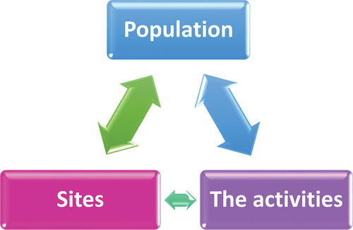
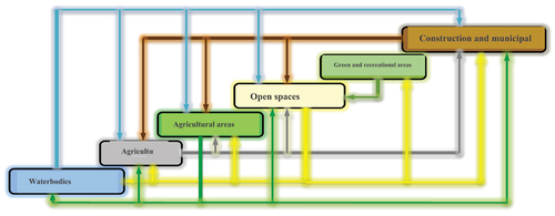
3 Determinants of land uses: Three main elements define the uses of the land, which are sites, activities, and population, as these elements interact with each other to allocate land uses (H. A. R. Kammouneh, Citation2010), Figure ).
Figure 1. The main elements that define land use (H. A. R. Kammouneh, Citation2010).
4 Land use change: The decision to change land use relates to the centers of gravity that make up the urban land market (land, owner, investor, and community). On the other hand, the decision to change should have legal status from two sides (H. Kammouneh, Citation2008). The most important lies in the approval of the local community for the new use as an expression of the actual need of this community, and the other side is legal approval through legislation related to this matter.
5 Reasons for changing urban land uses: When changing social and economic relations, there is a need to change activities and activities, that is, change land uses. Changes also occur due to the inability to implement the basic plan because the administrative apparatus is inefficient, and implementation cost is very high. In addition, demographic factors also cause a change in use. Therefore, it is imperative to conduct a prior study of any change in urban land use (AlKinani, Citation2007) and the effect of changes on the various aspects of the basic scheme, i.e., other uses adjacent to the use that will be changed must be studied (AlKinani, Citation2007).
The causes of changing uses of land in the city may have economic and social motives as a result of significant transformations in the growth of cities and an increase in the population (AlBakri, Citation2014), or their cause is internal or external conditions that occur in cities and their activities (Diep et al., Citation2022).
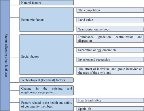
6 Factors affecting the types of urban land uses: Urban land uses are subject to the influence of a group of factors that influence, in one way or another, the arrangement and structure of these uses spatially. Figure below shows these factors (Diep et al., Citation2022).
Figure 2. Factors affecting the types of urban land use.
2. GIS program
71 The concept of the GIS program: The American Environmental Systems Research Institute (Esri) (Environmental Systems Research Institute) shows that geographic information systems are coherent complex systems that include computer components, programs and databases, in addition to individuals and the results, an accurate inventory of spatial information, storage, updating, processing, analysis and presentation (AlHakim, Citation2008, D. Rafiq, 2005).
2.1. Advantages of GIS related to land use
Geographic information systems (GIS) provide information in the land use field, such as ground data that illustrate the pattern of land use, data related to buildings and determine the type of building or its purpose, the shape of the buildings, their heights, ground area, and others. GIS relate to determinants where the separation zones or prohibited security zones stand out, those that are governed by pollution conditions, or those restrictions related to determining heights, areas of water buffers, or areas suitable for good and distinguished housing and others. This can contribute to harmonizing the different policies and what happens to the land uses in terms of change and monitoring of these changes with appropriate policies and estimating the reality and details of future spatial changes in a particular area so that the land uses optimally play the required role, so expected growth is accommodated with appropriate plans and strategies (AlHakim, Citation2008). In view of the advantages of the program, the change in urban land uses in Kufa city will be determined using this program, and through it also, functional and spatial change in quantity and quality will be proven as a function of time using mathematical tools, a move away from manual fieldwork that takes a long time and effort and if it gives tangible results, they are often inaccurate in comparison to technical electronic precision.
3. Practical study
3.1. About the city
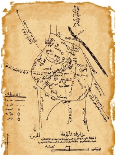
811 Origins and administrative borders: It is the second city built under Islam after Basra in the year 17 AH (Amin, Citation2001). It was known before Islam in Suristan, but after the Arabs inhabited it, they called it Kufa, meaning a rounded place of gravel and sand (Farhan et al., Citation2000). Figure shows that it was a city with nearly round borders, penetrated by six main roads connecting the city center (AlMidan) and the areas adjacent to it. It is also noted that three branches of the Euphrates River pass through it, and in the middle of it is AlMidan.
Figure 3. An ancient map of Kufa city in the seventh and eighth centuries AD first and second Hijra (Jasim et al., Citation2021a).
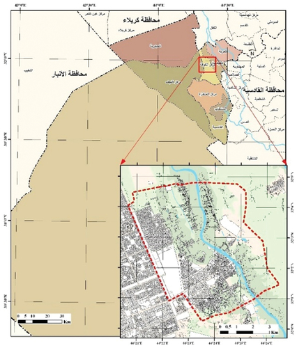
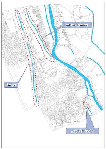
Kufa is an Iraqi city located in the AlNajaf Governorate on the western side of the Euphrates River, 170 km south of Baghdad (see, Figure ). It is bordered on the north by AlKifl district (Babel governorate), on the east by AlMahanawiyah and AlSalahiya district (AlQadisiyah governorate), on the west by Keri Saada, on the south by the Abi Sakhir district (AlManathira district), and by AlHirah (The Municipality of Kufa, Citation2013,27), Figure .
Figure 4. The location of the study area depending on the data of the ministry of municipalities and public works.
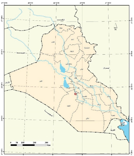
Figure 5. The boundaries of the study area depending on the master plan 20,072,030.
3.1.1. Population of Kufa city
Table shows the number of residents of Kufa city:
Table 1. The Increase in The Population of Kufa City Over Several Years Depending on/Najaf Statistics Directorate, Statistical Group for The Years (1997, 2003, 2008, 2013, 2018), Unpublished Data for 2013 & 2018
3.1.2. The date of the master plan for Kufa city
Though Kufa city was planned, it remained unchanged until the last two centuries, during which it passed through several stages in which the use of the land developed and formed, and these stages came in the form of basic plans for the city. However, the plan did not cover several aspects, which led to the development of a new separate plan for the city in 1974 AD with a time limit for the plan of (20) years. It is the first basic scheme in the modern concept of Kufa city, and before this date, there was no plan for the development of the city scientifically. In turn, it went through three phases, during which the land use in the city changed. It was developed by the Directorate of Planning and General Engineering in the Ministry of Municipalities, and it was proposed to expand the city until 1995 AD, when its area was (999.2) hectares. Then, the second basic plan for the city was drawn up in 1982 AD to address the health and environmental aspects that the first plan neglected and to meet the housing need until 2000 AD, and its area reached (1533) hectares. Finally, the basic plan was drawn up for the year 2007 AD to accommodate the population increase, accelerate urban growth and address the weaknesses in the previous plans (Table ), (Republic of Iraq, Citation2013), (Figures ).
Figure 6. Showing The Basic Plan For The Cities Of Najaf And Kufa In 1958.
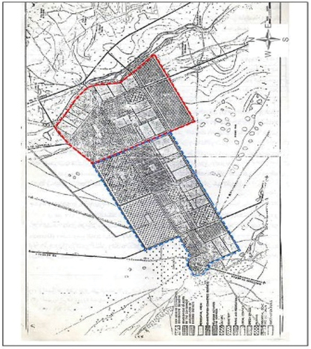
Figure 7. The Basic Plan For Kufa City In 1974.
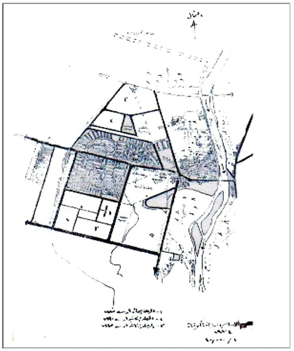
Figure 8. The Basic Plan For Kufa City In 2007.
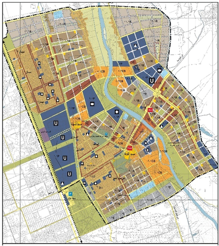
Figure 9. The Basic Plan For Kufa City.
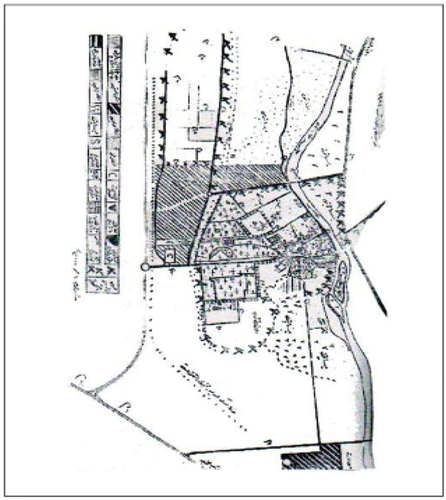
Table 2. The Master Plans Area for Kufa City
The previous plans illustrate the gradual change in land use in the city, which began in the mid nineteenth century from the right side of the coast of Kufa, without the left side because the latter was 56 meters lower than the former and was vulnerable to floods. Residential plots and neighborhoods emerged due to the escalation of migration from the countryside to the city, which led to the expansion of the city’s land use. This expansion took on a random character despite the decisions and organizational plans until the emergence of the first plan (Republic of Iraq, Citation2013). See, Table below:
Table 3. Urban Land Use Areas In (Hectares) For Each Master Plan for Kufa City Based on Urban Planning Directorate/Base Plan for 197,419,822,007 AD Ministry of Municipalities and Public Works, Najaf Municipality Directorate, Kufa Municipality Directorate, Town Planning Department
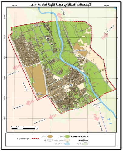
The change and development in the basic plan remained continuous until it was possible to clarify the reality of the situation in 2018, as shown in Figure :
Figure 10. Kufa city 2018 AD with all the land use in the city and its contour lines based on the baseline map and satellite images and using GIS.
3.2. Practical steps for research
• Satellite images for the study years (2003), (2008), (2013) & (2018) A D, the satellite Quick bird,with a resolution of 0.6 m.
• Preparing maps of Kufa city showing the boundaries of the basic plan for Kufa city (updated)
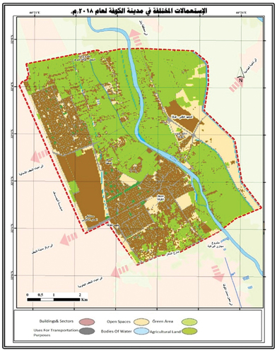
• Creating a database in the program, drawing the boundaries of the basic plan for Kufa city and the total area of the current plan and according to the existing uses in the city, which can be deduced from satellite images for the years 2003, 2008, 2013 & 2018, as shown in Figures .
Figure 11. The Land Use Layer For Kufa City 2003 AD.
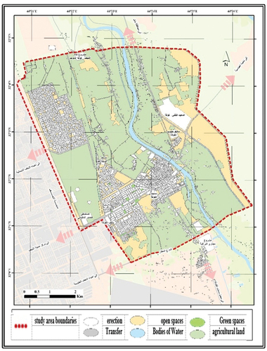
Figure 12. The Land Use Layer For Kufa City 2008 AD.
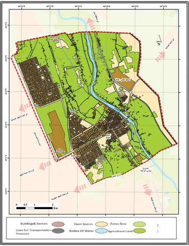
Figure 13. An Image Of The Land Use Layer For Kufa City, 2003 AD.
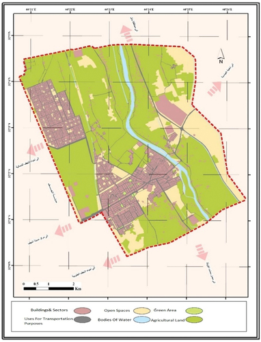
Figure 14. An Image Of The Land Use Layer For Kufa City 2008 AD.
• Within the boundaries of the updated basic plan, all the areas are contiguous without any overlap between the uses through the command (Topology), in addition to the road and street network being surveyed to achieve the highest possible spatial and survey accuracy and by using the command (Erase).
• When drawing, a layer is created that represents the land uses and includes all types for years (2,003,200,820,132,018) so that it is given the appropriate coding and reviewed together. By means of spatial analysis tools, this layer is converted into an image for each year separately, as well as in Figures , ), which show the resulting maps as pictures. Here, the highest accuracy is chosen and can be achieved.
Figure 15. The land use layer for Kufa city, 2013A.
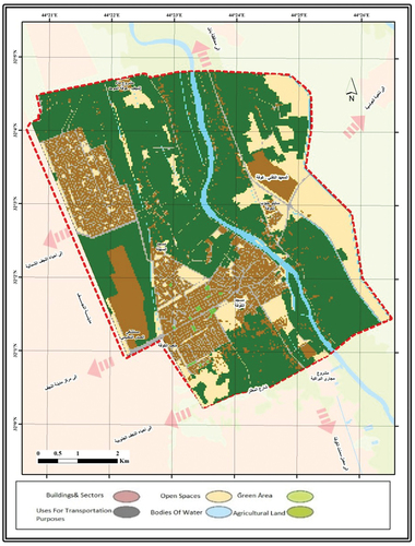
Figure 16. The land use layer for Kufa city 2018 AD.
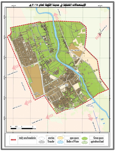
Figure 17. An image of the land use layer for Kufa city, 2013 AD.
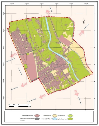
Figure 18. An image of the land use layer for Kufa city 2018 AD.
Through the tools of spatial analysis, each image was taken and a process of reclassification was conducted for it, that is, a reassessment of the numerical value corresponding to each category of uses from the default value within a geometric numerical sequence, so that each type of use had the numerical value that it represents in the new, reclassified image, with a note Repeat this process for the four academic periods, according to the values shown in Table .
Table 4. The numerical values corresponding to each type of use
3.3. The reality of land uses for Kufa city for the academic period from 2003 to 2018
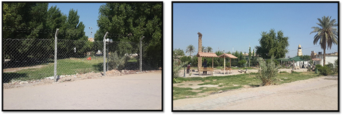
The boundaries of the updated base plan were adopted as they were matched to the satellite image and work within the city during the years 2003 AD (not the boundaries of the approved plan in 2003 AD), 2008, 2013 and 2018: The planned uses are what can be explored through the program, and these percentages belong to the reality the situation, regardless of whether it was in accordance with the approved standards or in violation of them. The stability and the security situation at that time and the conditions in which the country was living necessitated that it conformed to the approved plan without any significant transgressions. It should also be noted that these uses have changed significantly as a result of the conditions (political, security, economic, technological, and cultural) that the country went through during this period, as the area of the construction increased, and most of this increase came due to the encroachment on agricultural land as a result of its low cost and transformation to residential lands, with residential homes spreading in the southern and northern areas of the city randomly, followed by the construction of roads, the electricity system, the drinking water and sewage network to serve these areas. This research focuses on the significant increase in construction, mostly in the housing sector, and an increase in the use of green and recreational areas, as attention has been given to these areas recently in terms of afforestation of squares that mediate residential shops or public squares, which have been neglected for years, Figures .
Figure 19. Pictures Of Changing Land Use Random Homes On The Outskirts Of Kufa City Based On Satellite Images 2013 And Basic Design For 20,072,030.
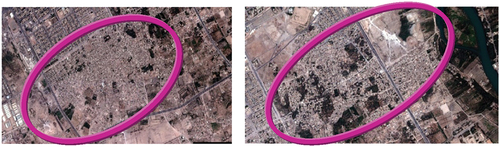
Figure 20. Picture Of The Green Areas And Squares In Kufa City, Which Interest Has Increased Recently.
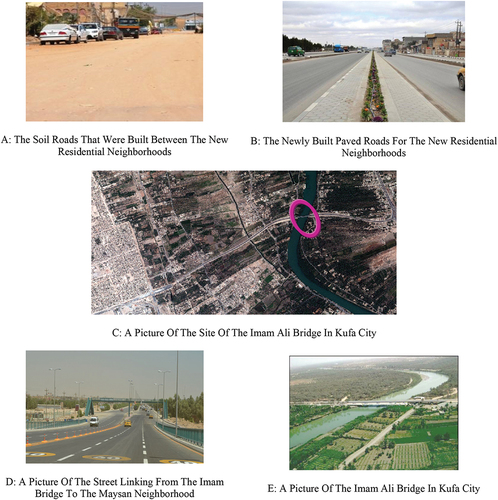
There was also a significant increase in the use of transportation, either paved or unpaved roads (soil roads), in addition to the construction of the Imam Ali Bridge (peace be upon him) and the roads distributed from it to the neighborhoods of Kufa. Note Figure , and there is also an increase in the use of flat water as a result of the development of water resources and irrigation channels, while a significant decline in the values of open spaces and agricultural areas, as a large part of open spaces, was observed. Agricultural and open lands have changed to other uses, such as housing.
Figure 21. Transportation Roads in Kufa City.
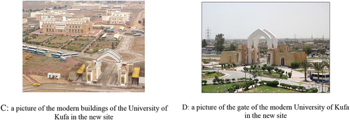
There was also a cluster in other uses, such as educational use, that occupied one of the sites that were occupied by the agricultural function, where the buildings of the faculties of the University of Kufa were in one location in a studied manner and characterized by legal legitimacy; that is, it is a spatial change that takes into account planning considerations; note Figure .
Figure 22. The educational land use in Kufa city.
From a review of the previous plans and forms, the land use change in the city is a result of the encroachment on agricultural lands, open spaces and some other detached and unimplemented uses and their transformation into residences. This constitutes one and even the most important type of functional change in the city.
4. Quantitative results of change monitoring
To achieve the objectives of the research, appropriate (GIS) tools were utilized for this purpose. A statistical method was adopted that took from the previous geometric sequence a graphical sorting method, through the probability rule, according to which the results of the change in urban land uses were reached, at the level of Kufa city within the boundaries of the updated base plan and according to the aforementioned uses, according to the following steps:
1. Through the GIS program, mathematical spatial analysis tools are used to determine the change between images for the years (2,003,200,820,132,018).
2. From the previous spatial analysis tools (Tool Box), the resulting uses are determined through the two images, where the program extracts the variable uses for each use separately and shows what this use was and what it has transformed, or that it may remain the same without change; all of this is statistically proven through numerical values. The resulting numerical value reflects the change in a particular use and its transformation into another use. Using the program, the following results appeared, Table , which clearly gives the direction of changing each use, for example, the numerical value (150) shown in the table. Through the analysis, it appears that it came from the difference between the numerical values and that this indicates a change in the uses of the land. It can be represented that the constructions have changed to relocation regardless of the method, and each of the uses has gone through a set of changes and fixed areas against each change. There are areas that have not changed, meaning that every use within them remained unchanged during the study period, represented by the outcome (zero), as shown in Figure in green in each case.
Table 5. Table 5 results of the land use change for the period 20,032,018 for the study area depending on the geographic information systems program
3. To prove the validity of the research results, the total areas (variable and fixed) shown in Table must be equal to the area of the study area, which is the total area of the base plan (20,072,030) amounting to (49,110,116) m2. According to the following table, the results can be represented in the above through the program by the final map that represents the results of the change in Kufa city and as shown in Figure , where the variable and fixed areas were represented by the colors shown against each type of use and according to the direction of its change by each period:
5. Analysis of the results of the study of change in land use (20,032,018)
Through the temporal change occurring in the period specified in the research, it becomes evident that there are significant spatial changes resulting from the change in the use of the land, which is the period during which the country, in general, underwent radical changes for the following reasons, and illustrated by Figure below:
Figure 23. Pictures Of the Change in Land Use Of Kufa City for the periods (2003-2007-2013-2018), Based On Satellite Images And Basic Design For 2007-2030
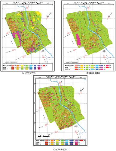
Figure 24. Functional Changes Trends Charts for Each Land Use That Occurred in The City.
1. The disappearance of some categories of land use, such as the open drainage canals in the southern part of the city, that were cancelled (Figure ).
Figure 25. The Locations of The New and Destroyed Drains in Kufa City During the Period 20,032,013.
2. The growth of some categories of land use against the shrinkage of others, as residential use has grown and spread widely, changing all the uses that were before it and on areas not designated for it, thus reducing other uses.
3. The emergence of new uses, such as building roads, bridges and tunnels, in an area that did not perform this function, but changing previous uses in it was in a deliberate manner, in addition to constructing new drainage to serve agricultural lands, Figure .
6. The spread of some categories of land use, such as green spaces and parks, was very low
By discussing the aforementioned factors in the theoretical framework of the research, it was found that:
The encroachment on agricultural lands in the outskirts of the city by residential and some other functions was evident by the prominent role of natural factors influencing the use of the land, where the decrease in the values of lands in remote locations leads to a change in their use, such as agricultural lands. At the same time, the high land values in the city center and nearby areas also led to a change in the land use of another kind. Here, competition played one of the most important economic factors based on another factor, namely, the value of the land to the exclusion of the (less competitive) residential job, where the dispersal of the residential job from the center of the city was noticed with the concentration of other uses, such as commercial, recreational and tourism, in its place.
Additionally, the bloc that occurred in the educational function represented by the buildings and colleges of the University of Kufa, whose location was agricultural lands with a few buildings under construction belonging to the presidency of the university in 2003 AD, Figure (), became a fully performing educational function, i.e., the plot of land was transformed The agricultural function shifted to another function, educational, as a result of the gathering of the university’s colleges’ sites in one center during this decade, Figure ). The transport factor also contributed to opening new horizons for expansion as a result of the development taking place, in addition to the use of technology that provided everything and did not make the link to a specific site justified.
The change that occurred in the use of agricultural lands, open spaces, water bodies and some constructions, which were converted to the use of transportation, was studied and planned, as these uses were changed to construct the road leading to the Imam Ali Bridge, which connects Kufa Street. The new district in the Maysan district to the city of Najaf was also studied, including the construction of some other roads to serve the residential neighborhoods. The change that converted agricultural lands, to educational use was represented by the University of Kufa, which included part of the change of agricultural use to construction), and led to the formation of university buildings, as well as changing a section of open spaces to green areas, as part of the campaign of afforestation and expanding green and recreational spaces to serve the residents, as well as the environmental. The important thing here is that it was legitimant and represented the interests and desires of the local community.
The change in the use of agricultural lands and open spaces to construction was random and unplanned, which caused great harm to the city and economic, social and environmental aspects. This represents a case of encroachment on land and, as well as the change that affected some green areas and turned them into open spaces, which results from neglect and non observance of use in some areas. The change that took place in some agricultural lands to open areas disrupted environmental systems due to the gradual decrease in agricultural areas.
The impact of individual and collective behavior on the uses of the city’s land has appeared among individuals or groups, in light of the needs and desires for defining their own goals under economic and social aspects of families, making plans and solutions to their problems. This would change a specific use automatically, such as the change that affected agricultural land and open spaces to construction, most of which was for housing).
The change in the prevailing and neighboring use pattern was also evident in the change in water bodies, a drain serving agricultural lands, which necessitated the need to change it to another use. An alternative drain was located in a new site to serve agricultural lands that also imposed a need, so open spaces and agricultural lands were changed to meet this need at the new drainage site.
There was a lack of consideration for factors related to health and public safety and spatial appropriateness, as the laws for controlling and distributing land uses were not adhered to, and the population densities exceeded the permissible limits, with negative effects in terms of deviant social behaviors and security. This was is in addition to pollution and damage to the surrounding environment, the waste of land, and failure to implement the principle of sustainability.
• The weakness of the methods of control over the implementation of urban land use plans led to this significant change in land use, and this weakness is concentrated in the following:
✓ Lack of commitment to the basic plans of the city and negligence in the application of zoning methods.
✓ The great neglect that affects divided and subdivided lands, where large lands were allocated for a specific use without the ability to implement this use or follow up on the land that was screened for it, is overtaken by another use without taking into account planning considerations.
✓ The negligence in applying the policies of imposing taxes or applying them to certain parts of the city without others facilitated land speculation and raised prices.
✓ Not applying the systems of guidance and directing land uses in a reminiscent way and the complete absence of planning awareness created an atmosphere suitable for abuse and random changes.
✓ The participatory method was not applied or the type of land changed, and if it was applied, the shift of land use from agricultural to urban land would have been studied, with specific directions and areas of focus.
In view of the unstable nature of the economic, social and political conditions that the country witnessed after 2003, and in view of the great weight that Kufa city receives from all these changes due to its characteristics, it performs a number of functions that serve its residents and the residents of the neighboring areas, with an economic return to the city. Religious jobs are the most prominent of those jobs, and drivers are some of the other jobs. This job is one of the mains one in Kufa city because of the Kufa Mosque, the Sehla Mosque, and the shrines of the saints and the righteous. All uses in the city, especially services, have changed as a result of this population increase. Maintaining land uses in the city is one of the most difficult tasks, as everything related to urban systems changes, from residential areas, road and transport networks, to green and open areas, and so on.
The most important reasons for changing land use in Kufa city can be summarized as follows:
1. The lack of a good distribution of investments, with the concentration of investments in a certain area (the central area and the central street) made it a center of attraction for residents of other cities in search of job opportunities and the availability of services.
2. Weak municipal oversight over urban construction work, which led to the emergence of overrun areas, due to urbanization of the area, as well as the support that some transgressors receive through state employees and politicians for personal purposes.
3. The rise in land prices and rental allowances for housing, with the scarcity of urban land supply and competition from other nonresidential uses.
4. The low level of planning awareness among a few citizens and their lack of familiarity with planning laws lead them to intentional cases of transgressions on state lands.
The most important effects of these changes in land use in Kufa city can be summarized as follows:
1. After the great change that the city is witnessing, it has become difficult to implement land use plans using the methods of control known as zoning, excretion and the systems of guiding and directing the land use plans recommended by the master plan.
2. Random changes led to confusion of the prepared system between land use planning, transportation planning on the one hand and environmental planning on the other hand. The development of new roads led to the abolition of some water sources for agricultural lands, which led to changing its agricultural function to other jobs and shifting irrigation schedules to new areas, at the expense of agricultural and open lands.
3. These changes resulted in traffic problems, such as runover accidents and interference between traffic and pedestrians, as well as noise and pollution resulting from traffic density, forcing the executive authority to try to solve this crisis. Absorbing the increase in traffic led to the construction of bridges, tunnels and new roads, in addition to problems related to services.
4. The encroachment privacy when the new uses overlap with residential use and the resulting inconveniences to families. Living on agricultural land, also causes a violation of the privacy of housing with regard to environmental damage, in addition to other social problems resulting from that.
5. There was a significant increase in land prices and rents for houses and apartments due to competition between land uses in nearby sites, which has burdened poor families.
It should be noted that these effects can be bypassed in the event of allocating residential plots, sorting them with special mechanisms, and distributing them among certain categories of citizens and people with limited incomes to ensure the reduction of abuses on land for housing purposes.
7. Conclusion
From the results that have been reached, the following can be concluded:
1. Land use planning is a very important practical procedure to meet the needs of the population and control aspects of nonurban expansion by developing a basic plan stemming from the reality of the city to accommodate population increases and the variation in the natural, economic and social factors occurring in the city.
2. There are significant changes that occurred in the use of land in the city as a function of time due to human intervention, resulting from the inability of the basic plans that were drawn up for the city (from 1958 until the last basic plan in 2007) to keep pace with the rapid urbanization of the city as a result of the continuous population increase.
3. The biggest problem in the city is the problem of housing units that exceed the basic plan, as the presence of agricultural lands, orchards, and wide taboos within the municipality’s borders made it vulnerable to encroachment and random urbanization, which caused the emergence of backward neighborhoods on a large scale in the city and outskirts.
4. The change in the use of agricultural lands, open spaces, water bodies, and some constructions that was converted to use (transportation) had positive outcomes because it was thoughtful and planned. The change that affected agricultural lands to educational use, which was part of changing agricultural use to buildings, and changing open spaces to green areas, was also studied.
5. The change in the use of agricultural lands and open spaces into construction had negative consequences that would greatly damage the city because it was random and unplanned. The same applies to the change that took place in some green areas, turning them into open spaces, and the change that took place in some agricultural lands into open spaces.
6. There was an absence of the state’s authority, represented by its supervisory agencies, to perform the role required of them, due to the weakness of the administrative and supervisory apparatus in the municipalities. These overlooked irregularities led to the widening of this problem, just as changing any use leads to a change in the uses adjacent to it.
7. The phenomenon of change in uses is due to the failure of traditional programs for land use to achieve their goals due to weak financing programs and the inability of local administrations to develop and implement plans that take into account the specificity of the economic and social structures.
8. Geographic information systems play a role in limiting and determining changes in urban land use, and in providing data and information about cities in an organized manner that can be easily achieved in a short time and with little effort. GIS have the ability to provide a comprehensive view of cities without going to the site, helpful for preparing of planning and legislative bodies and the executive branch to facilitate applying laws, identifying defects, weaknesses and problems, and finding quick solutions by setting and drawing plans and keeping them for easy reference and modification.
8. Recommendations
1. Transgressions should be controlled through the formation of committees in the municipality whose mission is to follow up on the violations of land belonging to the state or agricultural lands, to limit random expansion on them and to cancel the right to dispose of the transgressor. If the lands are owned by individuals, the Ministry of Agriculture must take appropriate measures to prevent the owners from using the lands for nonfarming.
2. Attention should be given to the housing sector by establishing new neighborhoods to relieve pressure on the city, sorting new plots of land for residential use, and distributing them through a specific mechanism to citizens to ensure that housing needs are not overrun. Special policies should exist for building residential homes, including for providing grants, bank loans, construction materials and all necessary supplies
3. Encouraging the investment of vacant lands, parceling them out, and making them residential areas or any other use serving the city.
4. It is necessary to introduce GIS techniques in planning projects to shorten the amount of time and effort spent collecting, presenting and producing information, where the reality of the situation is presented then analyzed to make a decision based on reality.
5. The research recommends followingup the work and studying the changes in detail on the overall usage sectors in order to track down the basic factors behind the functional changes in the basic plan fabric and to know their impact in order to control for them in the future with mechanisms and planning methods.
6. To limit the random expansion at the expense of agricultural lands, the urban expansion on agricultural lands belonging to the state should be followed up through the following procedures:
Forming a committee in the Kufa Agriculture Department to monitor urban extension on agricultural lands.
Cancellation of the right to dispose of the trespasser, and if the lands are owned by individuals, the Ministry of Agriculture must take appropriate measures against them to prevent the owners from using the lands for nonagricultural purposes.
7. Due to the importance of Kufa city, it is necessary to create a database that includes all the layers that represent the uses of the land and that is updated periodically at intervals determined by specialists, planners and decision makers in the city.
Authors Consent to Publish
As Corresponding Author, I confirm that the manuscript has been read and approved for submission by all the named authors.
Disclosure statement
The authors declare that they have no known competing financial interests or personal relationships that could have appeared to influence the work reported in this paper.
Additional information
Funding
Notes on contributors

Nadhir AL-Ansari
Ahmed H. Rashid is an architect engineer and holds an M.Sc. in Urban design from the University of technology /Iraq since 2013. He Worked as an engineer at the Department of Engineering Affairs /University of Kufa. He is currently a lecturer at the Department of architectural engineering/Kufa University. His general interest are programs that deal with design and parametric design. He had many published papers in his field.
References
- AlBakri, H. M. (2014), ‘Urban morphology of the holy city of Karbala’, unpublished Master’s thesis, Center of Urban and Regional Planning, University of Baghdad.
- Al Eidani, A. A., Al Mula, T. J., & Al Kaabi, M. M. (2017). Spatial Changes in Urban Land Uses in Basra for, 1977–31.
- AlHakim, H. I. (2008). Planning of the Arab Islamic City (Najaf and Kufa As a Model. Published Research, Kufa Literature Magazine, (1).
- AlJubouri Fouad Abdullah, A. Geographical Analysis of Functional Changes within the Urban Structure of the Holy City of Najaf after 1990, Doctoral Thesis, Faculty of Arts, University of Kufa, 2011, pp. 343545.
- AlKinani, A. (2007), ‘Religious land uses and their impact on the development of urban uses for the holy city of Najaf’, unpublished PhD thesis, Faculty of Education, University of Baghdad, p. 48.
- Al Mawla, T. J., 2013. mapping the changes of land cover in Basra province using Remote Sensing and GIS Technologies for 1973, PhD Thesis, University of Basra.
- Amin, H. H. (2001). The Kufa Mosque in History. Sumer Magazine, 5(1), 40.
- Diaa Rafiq, M. 2005. DecisionMakers’ Using Geographic Information Systems (GIS), PhD Thesis, Urban and Regional Planning Institute/University of Baghdad, pp. 32–55.
- Diep, N. T. H., Nguyen, C. T., Diem, P. K., Al Kafy, A., & Kafy, A. A. (2022, June). Assessment on controlling factors of urbanization possibility in a newly developing city of the Vietnamese Mekong delta using logistic regression analysis. Physics and Chemistry of the Earth, Parts A/B/C, 126, 103065. https://doi.org/10.1016/j.pce.2021.103065
- Edan, M. H., Maarouf, R. M., & Hassan, J. (2021, October). Predicting the impacts of land use/land cover change on land surface temperature using remote sensing approach in Al Kut, Iraq. Physics and Chemistry of the Earth, Parts A/B/C, 123, 103012. https://doi.org/10.1016/j.pce.2021.103012
- FAO. (1993). Guidelines For Land Use Planning. FAO Development Series, 1(Roma), 3–87.
- Farhan, S. L., Jasim, I. A., & ALMAMOORI, S. K., 2000. Historic City centers: reality and prospects for the future analysis of the transformations the city Of AnNajaf. file:///C:/Users/GroupX/Downloads/Guidelines%20for%20land-use%20planning.pdf
- Jasim, I. A., AlMaliki, L. A., & AlMamoori, S. K. (2022). Water corridors management: A case study from Iraq. International Journal of River Basin Management, 1–11. https://doi.org/10.1080/15715124.2022.2079662
- Jasim, I. A., Farhan, S. L, Al-Maliki, L. A, & Al-Mamoori, S. K. (2021a). Climatic treatments for housing in the traditional Holy Cities: A Comparison between Najaf and Yazd Cities. IOP Conference Series: Earth and Environmental Science, 754(1), 012017. https://doi.org/10.1088/1755-1315/754/1/012017
- Kafy A, A. L., ALFaisal, A., Rakib A, A. L., Abdul Fattah, M., Rahaman, Z. A., & Sattar, G. S. Impact of vegetation cover loss on surface temperature and carbon emission in a fastest growing city, Cumilla, Bangladesh. Building and Environment;208 15 January 2022, 108573. https://doi.org/10.1016/j.buildenv.2021.108573
- The Kanani. Kamel, K., AlQura, G., & Mustafa Abdul, J. 2007. Determining the levels of interaction between urban land uses by adopting spatial analysis techniques (Najaf AlAshraf Study Area. Published Research, Journal of Planning and Development, 16
- Kammouneh, H. (2008). ‘Transformations of the traditional ecosystem in the decisions of urban fabric of the city’, researcher thesis for master degree in architecture. University of Baghdad.
- Kammouneh, H. A. R. (February 2010), ‘The holy cities centers in Iraq, the city of Najaf as a model, problems and solutions’, World Conference to preserve the sacred sites, Baghdad.
- The Municipality of Kufa., Department of town planning, 2013. unpublished data for the year 2013.
- Republic of Iraq., Ministry of planning and development cooperation, central bureau of statistics, najaf statistics directorate, statistical group for the years (1997, 2003, 2007, 2013), unpublished data for 2013. 2013
- Waseem, S., & Khayyam, U. Loss of vegetative cover and increased land surface temperature: A case study of Islamabad, Pakistan. Journal of Cleaner Production;234 10 October 2019, 972–983. https://doi.org/10.1016/j.jclepro.2019.06.228
- w, N., Hailu, B. T., & Fetene, A. (2019, November). An assessment of the vegetation cover change impact on rainfall and land surface temperature using remote sensing in a subtropical climate, Ethiopia. Remote Sensing Applications: Society and Environment, 16, 100266. https://doi.org/10.1016/j.rsase.2019.100266
- Zhang, C., Zhang, M., Al Kafy, A. A., & Tan, S. (2021). Simulating the relationship between land use/cover change and urban thermal environment using machine learning algorithms in Wuhan City, China. Land, 11(1), 14. https://doi.org/10.3390/land11010014.