
 ?Mathematical formulae have been encoded as MathML and are displayed in this HTML version using MathJax in order to improve their display. Uncheck the box to turn MathJax off. This feature requires Javascript. Click on a formula to zoom.
Abstract
Central Rift Valley (CRV) Ethiopia is an important region in terms of its vast ecosystem services (ES)and enriched biodiversity. However, its ES and biodiversity are under terrific pressure from hurried population growth, unsustainable developmental activities, unplanned urbanization, aggressive agricultural expansion, climate change, and the associated changes in land use and land cover (LULC). This study was aimed at analyze LULC changes in the Ethiopia CRV areas from 1985 to 2015 through Geographic Information System (GIS) and Remote Sensing (RS) techniques. Satellite images were accessed, pre-processed and classified. Field observations, discussion with dwellers (elders) were also employed to validate results from remotely sensed data. Major LULC types were detected and change analysis was executed. Consequently, nine LULC changes were successfully evaluated. The classification result revealed that in 1985 the area was covered by 44.34% with small-scale farming followed by mixed cultivated/acacia (21.89%), open woodland (11.96%), and water bodies (9.77%), respectively. Though the area measure varied among land use classes, the trend of share occupied by the LULC types in the study area remained the same in 1995 and 2015. In this research increase in small and large-scale farming, settlements and mixed cultivation/acacia while a decrease in water bodies, forest, and open woodlands is noted. Accordingly, the overall accuracy of this study was 84.46, 86.86 and 88.86 with kapa value of 0.82, 0.84 and 0.87, respectively. Lastly, the DPSIR framework analysis was done and integrated land use and policy reform are suggested as a response for sustainable land use planning and management.
PUBLIC INTEREST STATEMENT
The study was designed for better documentation of LULC information for the central Rift Valley areas which will supply important information for further environmental management. The area is well known by water resources and endowed by various biodiversity. However, due to many negative triggering factors, such as population pressure, environmental unfriendly expansion of investments, urbanization, deforestation etc…, its natural quality is deteriorated and degraded in the course of time. Therefore, studying the status of the area with scientific approaches will help to know the trend and develop a restoring mechanism. Therefore, in this study LULC analysis since 1985 to 2015 is assessed with help of GIS technology and finally policy options are forwarded for sustainable land use policy.
Competing interests
The authors declare that they have no competing interests.
1. Introduction
Land usage states to the deployment of land for diverse purposes, whereas land cover specifies the regular and non-natural cover on the land surface (e.g., natural vegetation, agriculture, bare earth, water bodies, and man-made structures) (Mondal & Zhang, Citation2018). Ethiopia has a very varied set of biotas ranging from humid forest and extensive wetlands to the desert (Tefera, Citation2011) and inside these miscellany environments, LULC changes are a ubiquitous and common occurrence where agricultural deeds and settlements dominate rural landscapes affecting ES. The land is finite and non-renewable resource deliver services needed for human well-being (Tolessa, Senbeta, & Kidane, Citation2017) and ecosystems provide a wide range of multiple services that vary in quantity and quality depending on the type of ecosystems and their status (Costanza et al., Citation2014; De Groot et al., Citation2012; Ma, Citation2005). Many of the land resource services, important for sustaining life on earth and maintaining the integrity of the ecosystem are fronting difficulty because land resources are falling under threat and stress in time. Thus, LULC changes have freshly developed a major attention area in the global research community (National Research Council, Citation2014; Rogan & Chen, Citation2004) because of its significant effects on climate change (Pielke et al., Citation2011; IPCC, Citation2013), biogeochemical cycles (Houghton et al., Citation2012), and ES and biodiversity (Phalan, Onial, Balmford, & Green, Citation2011).
ESs are the aids people get from ecosystems (Capistrano, Samper, Lee, & Raudsepp-Hearne, Citation2005) and not only provide a multitude of purposes, including clean air, fresh water, food, fuel, and other services, but also play a critical role in sustaining and improving human well-being, which is essential for regional landscape sustainability. However, over the past half centuries, nearly 60% of the studied ESs has been degraded due to increases in global population and economic growth, especially in drylands (Capistrano et al., Citation2005). Thus, to provide a better understanding of changes in degrading ecosystems and the potential for ecosystem restoration, ESs has been identified as an ecological concept important for policymakers and practitioners in recent years.
Land use/cover conversion is single amongst the leading pouring forces (Lambin, Rounsevell, & Geist, Citation2000; Lasanta, González-Hidalgo, Vicente-Serrano, & Sferi, Citation2006) on global and local environmental changes though its impact varies across space and time (Bryan, Citation2013; Costanza et al., Citation2014). Enlargement of farming, sprawl urbanization, deforestation and the day to day activities of mankind resulted in temporal and spatial changes in the land use/cover which in turn affects ES such as hydrological regulation and soil erosion losses (Rawat & Kumar, Citation2015). In Ethiopia, observed suggestion shows that there has been substantial LULC in diverse parts of the country (Girmay, Singh, & Dick, Citation2010). These changes have vital eco-friendly concerns at local, provincial and universal scales (Bewket & Abebe, Citation2013). At the local scale, land use changes affect watershed runoff, micro-climatic resources, groundwater tables, processes of land degradation and landscape level biodiversity (Lambin & Geist, Citation2008). A few decades ago, the CRV basin is known for its dense acacia woodlands that have now been transformed into agricultural and grazing lands(Gebreslassie, Citation2014). These have serious eco-environmental problematic exposed the region’s viable social and economic improvement (Collier & Dercon, Citation2014; Peng, Xu, Cai, & Xiao, Citation2011).
Land use/cover change is motivated by numerous causes from environmental and social dimensions in a land system (Gong, Yang, & Tang, Citation2015). Reasons for these changes are many faceted, however, the major among others are lack of proper land use policy (Teka, Van Rompaey, & Poesen, Citation2013). Thus, land cover dynamic becomes a concern of the 21st century with the dramatic implication for human survival. Water bodies (especially, wetlands and lakes) are, Important environmental components of the terrestrial landscape which cover a significant portion of the country total land area, performing significant ecosystem services (Amsalu & Addisu, Citation2014) like climate regulation, pollutant reduction, flood storage, drought control, water supply, and biodiversity conservation (Haslam, Citation2004; Mitsch & Gosselink, Citation2000). However, water body degradation is becoming more and more serious thereby accelerating the degradation ecological balance and environmental quality (Day et al., Citation2003; Dimitriou et al., Citation2008) and their biota are at risk from the combined effects of changes in Ethiopia. As a result of faulty use, the area has experienced fluctuations in lake level of tens to hundreds of meters in the past 200 years (Olaka, Odada, Trauth, & Olago, Citation2010). Many authors reported also as climate changes coupled with water for domestic use, fisheries, small and large-scale agriculture (floriculture and horticultural farms) have altered the lakes hydrodynamics (Geheb & Abebe, Citation2003; Hengsdijk & Jansen, Citation2006a; Zeray, Roehrig, & Chekol, Citation2006; Olaka et al., Citation2010).
Hence, to this end, this research was initiated to analyze the land use and land cover changes in the CRV at three different temporal scales viz. 1985, 1995 and 2015 with a close look to the empirical and statistical relation of the LULC changes, mainly focusing on the ecological landscapes of CRV zone and its lakes likely to generate updated data and supplement the already recorded information that ultimately guides restoration and/or conservation intervention in the areas. Therefore, the main objective of this research work was to characterize GIS-supported LULC changes of the CRV Ethiopia and was addressed the following specific activities: (i) Conduct GIS supported LULC change analysis over three periods (1985; 1995 and 2015) and characterize LULC classes,(ii) Analyse and Prepare LULC change map and accompanying data for LULC classes, (iii) Identify the drivers and analyzing impacts of LULC changes using Driver-Pressure-State-Impact-Response (DPSIR) framework to depict sustainable landscape restoration.
2. Methods and materials
2.1. The study area
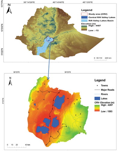
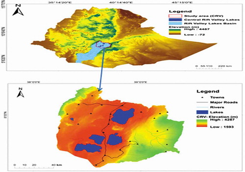
Figure presents the CRV region where this study was conducted. Geographically, CRV is located between 38º15ʹE and 39º25ʹE and 7º10ʹN and 8º30ʹNcoordinates. The CRV in Ethiopia makes an area of about 1.3Mha (Hengsdijk & Jansen, Citation2006b). This is a section of the Main Ethiopian Rift comprises a significant part of the great African Rift Valley system that stretches from the Red Sea to Mozambique crossing Ethiopia, Kenya, and Tanzania. It is divided into three subsystems: Chew Bahir (Lake Stephanie), CRV, and Afar triangle (Muzein, Citation2006). CRV comprises Ziway, Langano, Abijata, and Shalla Lakes from the rift valley basin and Hawassa, Abaya, Chamo, and Chew-Bahir lakes from the lower sub-basin. These lakes, which once formed one large water body, support important biodiversity resources that have global significance. The CRV basin contains unique fauna and flora species of which a significant number are endemic. The area is an important breeding and feeding site for some rare species of resident and migratory birds. A good example is Lake Abijata and Lake Shala form together a National Park, which has been submitted as candidate site by the Ethiopian Government to the Ramsar convention on wetlands.
Figure A1. Location of the Great Ethiopian Rift Valley (Hatch & Wells, Citation2012) and the study area CRV.
2.2. Data sources and method of analysis
2.2.1. Satellite images
Spatiotemporal data of 2 Landsat 5 TM 30 m (1985 and 1995) images and one Landsat 8 OLI/TIRS 30 m (2015) image were downloaded from open access Landsat imagery services (Table ). Relative cloud-free specific date and year (January, February, and December) was used for the acquisition of Landsat imagery across the study area. GIS data on the administrative boundary, road network, towns, and river network were obtained from the GIS department of the Ministry of Water, Irrigation and Electricity (MoWIE), Ethiopia. A 30 m resolution Digital Elevation Model (DEM), based on Aster imagery was also employed. In addition, ancillary data were also utilized during analysis. All data were projected to the Universal Transverse Mercator (UTM) projection system zone 37N and datum of World Geodetic System 84 (WGS84), ensuring consistency between datasets during analysis.
2.2.2. Image pre-processing and classification
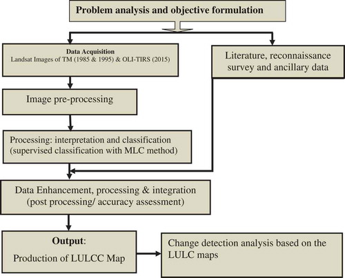
Image extraction, layer stacking and change detection were performed on the Landsat TM/OLI images obtained for different dates in order to create multi-band composite images since the study area lies on two scenes. Data were pre-processed in ERDAS imagine for mosaicking, and subsetting. Satellite image re-processing was conducted to establish a more direct affiliation between the acquired data and biophysical phenomena. Then land use and land cover change detection were analyzed for the last 30 years in GIS environ through hybrid classification technique (Figure ).
Figure A2. Work flow of the land use/cover mapping Methodology.
The analysis detects nine land use and land cover type (Table ). It was conducted using post-classification image comparison technique (Lillesand, Kiefer, & Chipman, Citation2014). Images of different reference years were first independently classified. The percentage of change within the same LULC class between two-time points is calculated as follows as stated in the values were presented in terms of hectares (ha) and percentages (%). Positive values suggest an increase whereas negative values imply a decrease in extent.
Where: Change (%): percent change in the area of specific land use land cover class between times in and in−1, Art: is a recent area of LULC at time t and Apt: is the previous area of LULC at earlier time t.
To calculate annual rate of change for each land use class, the difference between final year to initial year which represents magnitude of change between corresponding years was divided by the number of study years i.e. 1985–1995 (10 years), 1995–2015 (20 years), and 1985–2015 (30 years) respectively using the following Equation as stated by (Meshesha, Tripathi, & Khare, Citation2016):
Where: Annual RΔ = Annual Rate of change, Change (%) = % change in the area of specific land use land cover class (Equation (1)) and ΔT = time interval between initial and previous LULC class in years.
2.2.3. Accuracy assessment
Quality evaluation is one of the first steps in making LULC (Giri, Citation2012). Thus, to check the accuracy and performance of LULC classification for 1985,1995 and 2015 imageries, Ground Control Points (GCP) and Goggle Earth image were used (Traore et al., 2018) and stratified random sample strategy was adopted to assess the accuracy of the classified map (Congalton & Green, 2009). Therefore, 450 GCPs were collected using a handled Garmin GPS for 2015 images and for 1985 and 1995 images GCPs generated from Google Earth were used and random pixels were generated for each classified image in ArcGIS 10.3 environ for comparison. Then, comparison of classified images and reference data was carried out statistically using error matrix (Table ). Accordingly, the over all accuracy of this study was 84.46, 86.86 and 88.86 with kapa value of 0.82, 0.84 and 0.87, respectively. The Kappa quantity, which measures the difference between the actual agreement of classified map and chance agreement of random classifier compared to reference data, was also calculated as (Congalton, Citation1991):
Where r is the number of rows, xi is the number of observations in row i and column i, xi+ and x+i are the marginal totals of row and column, and N is the total number of observed pixels. Moreover, while doing the ground truthing we have also incorporated information from field observation and discussion with dwellers (elders) on the environmental impacts of horticulture investments and the land use land cover changes in the area and particularly in water bodies.
3. Results and discussions
3.1. CRV land use/cover mapping and analysis (1985 −2015)
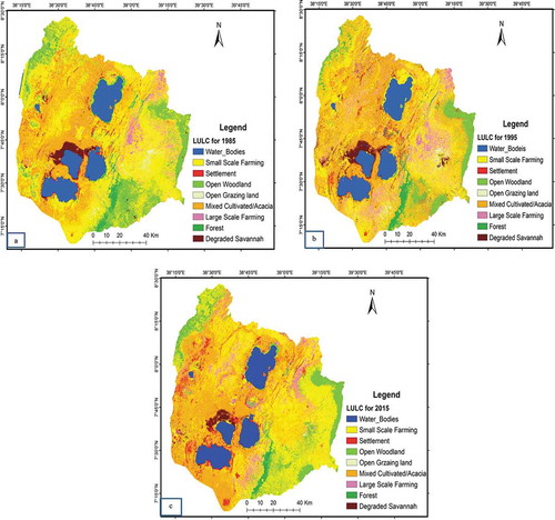
The Landscapes of the study area has undergone and experienced LULC changes in the last three decades (Figure , Table and ). The data show that there is a temporal change in LULC which may be in response to population and economic growth, public and private investments, and market and government actions (Berke & Kaiser, Citation2006). In 1985, 44.34% of the land was covered with small-scale farming followed by mixed cultivated with interspersed growth of acacia woods (21.89%), open woodland (11.96%), and water bodies (9.77%). The area under crop fields covered about 75% of the total areas in 2015 predominantly following the introduction of large-scale floriculture and horticulture farms however small-scale farming seems to decrease but was shifted to large-scale farming and water bodies were declined to 8.64%.
Figure A3. (a-c). LULC maps of the study area for the years 1985, 1995 and 2015, respectively.
Moreover, small-scale irrigated farming has expanded considerably with the establishment of irrigation water user associations that grow vegetables for the central market around Addis Ababa. The expansion of irrigated agriculture has caused some serious environmental problems including polluting freshwater lakes and a reduction in the levels of the lake water. Hengsdijk and Jansen (Citation2006a) explained also horticultural cultivation and floriculture greenhouse complex are built and widespread along the shoreline of Lake Ziway which increase pressure to nearby water assets and inputs (nutrients and biocides) might expand the hazard of environmental contamination”.
The expansion in agricultural extent might be associated with the increasing of small-scale irrigated land and expansion of large-scale farming (vegetable and flower farms) which might, in turn, affects the water bodies. This result is in agreement with a study conduct at Yazet Watershed, North Western Ethiopia (Tadesse, Suryabhagavan, Sridhar, & Legesse, Citation2017) and in Ethiopia Rift Valley (Ariti, van Vliet, & Verburg, Citation2015; Daniel, Daniel, & Muluneh, Citation2012) reported as, cultivated land is escalating as a result of population pressure, which demands agricultural land for food production. Authors (Assefa & Bork, Citation2016) also report similar results for Chencha and Arbaminch areas revealing that farmland inadequacy has now triggered farmers to cultivate marginal land areas and fragile ecosystems. Research finding of (Muzein, Citation2006) also confirms that more than 4/5 of the total terrestrial productive ecosystem for the Ethiopian central rift valley loss was agriculture.
The study also indicates loss of water body. The change results explain a continual decline in water bodies, open grazing land, forest and degraded savannah all over the study periods. The water bodies were decreased by 3.16% and 8.69%, respectively during the first two periods and in the third period, an overall decline of 11.57% was recorded. The highest rate of turn down of water bodies was recorded in the second period which might be associated with the expansion of industries (like water abstraction of soda ash), small-scale irrigated lands and large-scale farming (vegetable and floriculture farms) around the water bodies which consumes a lot of water for their activity. Many authors (Ayenew, Citation2004; Legesse & Ayenew, Citation2006) confirm that rift valley lakes and Feeder Rivers are exploited for soda extraction, commercial fish farming, irrigation, and recreation, and host variety of endemic birds and wild animals and levels of some of these lakes have changed temporally.
The maximum rate of degeneration of forest cover was also observed in the second period, which might be accompanied with a regime change which is in conformity with other studies (Demissie, Yeshitila, Kindu, & Schneider, Citation2017; Eshetu, Citation2014; Kindu, Schneider, Teketay, & Knoke, Citation2015) and deforestation through cutting acacia trees for charcoal production has also become a common phenomenon, as it is an easy cash source for some farmers since the main road that connects Addis Ababa to the Southern Regions provides an opportunity for roadside charcoal and wood sellers (Muzein, Citation2006). Conversely, settlements, mixed cultivated/acacia lands, and large-scale farming depict an escalating trend though vary and fluctuate in values. As (Ariti, van Vliet, & Verburg, Citation2018) revealed that in the past four decades grasslands, forests, and water bodies have declined mainly due to 1975 land proclamation, 1995 constitution, and water, irrigation, and investment policies, respectively. The annual LULC change Analysis revealed also settlement and mixed cultivated/acacia experienced an increasing trend whereas water bodies show a continuous decline throughout the entire study periods (Table ).
3.2. Changes in surface area of the CRV lakes (1985 −2015)
The Rift Valley Lakes Basin is one of the major river basins in Ethiopia with a total area of about 52,000 km2 (MoWR, Citation2010). The basin is characterized by a chain of lakes varying in size as well as in hydrological and hydrogeological settings. It constitutes nine lakes viz, Lake Ziway, Lake Langano, Lake Abiyata, Lake Shalla, Lake Hawassa, Lake Abaya, Lake Chamo, Lake Abbe and Lake Beseka (Alemayehu, Ayenew, & Kebede, Citation2006). However, significant changes have been observed in the hydrology of the Rift Valley lakes in Ethiopia over the past decades (Seyoum, Milewski, & Durham, Citation2015). The CRV encompassing Lake Ziway, Lake Abjiata, Lake Langano and Lake Shala which forms a complex and vulnerable hydrological system with unique ecological characteristics (Jansen et al., Citation2007) that are fed by streams of Meki and Ketar Rivers in the upstream portions of the catchments. These rivers drain into Lake Ziway traveling long distances and from Lake Ziway water is discharged into the Bulbula River, which flows to Lake Abjiata. But, regarding Lake Shalla, the available literature is very limited. This might be due to the little interest in the lake water because of its alkaline nature which discourages its use for irrigation purpose (Belete, Diekkrüger, & Roehrig, Citation2015; Raventós Vilalta, Citation2010).
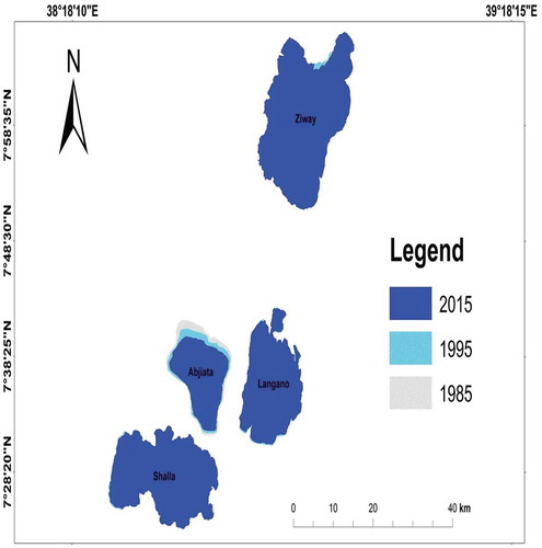
These lakes support a considerable wide variety of aquatic and terrestrial biodiversity and are habitat to different kinds of edible fish. Despite their services, human-induced and natural factors affect the water quality of the lakes (Ayenew, Citation2008; Ridgeley et al., Citation2012; Tefera et al., Citation2002). The change detection shows that water mount of Lake Abijata, Ziway, Langano, and Shalla showed a reduction of surface area during the entire study periods by 25.92%, 0.52%, 0.81% and 0.02% (Figure ; Table ) from their 1985’s size, respectively. Such kind of drastic change (e.g. Lake Abjiata) in surface area may have long-lasting negative consequences because the reduction in surface area of the four lakes intertwined negative impact on ecosystems, biodiversity, and livelihood of the community. This result is supported by (Olaka et al., Citation2010)who reported the fluctuations for Lake Zeway in lake level of tens to hundreds of meters in the past 200 years. Others reported similar trend as some lakes have shrunk due to the excessive abstraction of water like Lake Abjiata dropped significantly over three decades because of the extraction of water for soda and an upstream diversion for irrigation (Hengsdijk et al., Citation2007; Legesse & Ayenew, Citation2006; Yohannes, Mohammed, & Elias, Citation2017). Many studies indicate that the CRV Lakes and their watershed support unique ecological and hydrological characteristics which host to a wide array of economic, domestic and recreational activities, including the flower industry, soda abstraction and fish farming (Ayenew, Citation2007) and support the livelihoods of approximately 2 million people (CSA, Citation2013) and populate 1.9 million livestock (Meshesha, Tsunekawa, & Tsubo, Citation2012). Therefore, the reduction in the area of these lakes will have an impact on fisheries and lake-related ecosystems and causing the shrinkage of outflows of these lakes which is associated with environmental degradation, particularly the loss of aquatic bird life, water users along the rivers for domestic and livestock and irrigated farms.
Figure A4. Map of the four lakes in the CRV and change in surface area over the study periods (1985, 1995 and 2015).
The annual rate of lakes area change is also experienced a decreasing trend through. As presented in Table Lake Abjiata takes the lion share in an annual reduction by 12.07% during the first decades and by 13.39% by the next two decades. This result is in conformity with different findings of since the 1980s, as the water level of Lake Abjiata has significantly dropped due to the investment policies which affect the water resources of the area, especially river Bulbula and Lake Abijata and in response to natural condition variability. The use of river Bulbula, which is the main tributary for Lake Abjiata, for irrigation and factories, has caused the river to dry up, contributing to the shrinkage of Lake Abjiata. According to (Ayenew, Citation2002), uncontrolled water abstraction from Lake Ziway and the irrigation scheme on the River Bulbula significantly affects the water level of Lake Abijata. The fishery in Lake Abijata has totally collapsed and birds such as Lesser Flamingo (Phoeniconaias minor Geoffroy) and Great White Pelican (Pelecanus onocrotaluroseus) have been migrating to nearby lakes (Yohannes et al., Citation2017). If it continues like this, the lake will be facing an imminent threat of collapse and the existence of the Park would be unlikely and will be expected to share the bad history of Haramaya Lake. Hence, the minimum water flow on river Bulbula should be maintained through an integrated water resource management practices on a basin-wide scale to maintain the life in the Lake Abjiata.
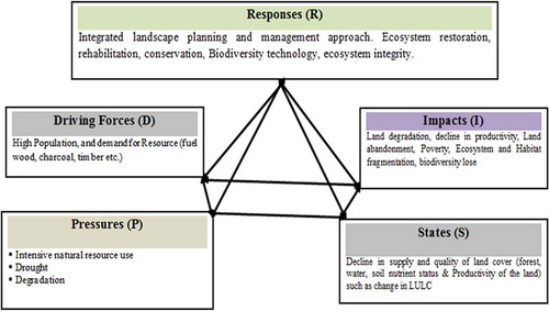
3.3. Drivers of LULC changes in CRV ethiopia
Many recent studies indicate substantial and speedy LULC change in Ethiopia manifested in environmental and economic impacts (Gashaw, Tulu, Argaw, & Worqlul, Citation2017; Miheretu & Assefa, Citation2017). Similarly, Ethiopia CRV changes in LULC are overseen by a combination of geographical, environmental and socio-economic factors. In addition to Imagery analysis, the field observation for current and discussion with elder dwellers for past also ensures that multiple effects of LULC change in the study area have happened between1985 and 2015. According to the elders’ response, the primary reason for the change is population growth, and added contribution of other causes such as environmental factors and economic development are also contributing significantly.
Scientifically, the drivers of land-use and land-cover changes are often classified into proximate and underlying causes (Lambin, Geist, & Lepers, Citation2003) and both driving forces caused the observed changes in the study area. The proximate causes are the immediate actions of local people such as agricultural expansion since the coverage of total cultivated land is increased over time. Author (Molla, Citation2015)further explained that the major causes of acacia woodland, shrub/bushland, and other vegetation change is directly related to agricultural activities and was a driving force for 20.4% and 27.8% of natural vegetation loss during 1973 to 2010 periods due to the increasing demand for food for the increasing household members. wood extraction, infrastructure expansion and others which change the physical state of land cover are also part of the proximate causes as of (Lambin & Geist, Citation2008) study.
As (Geist et al., Citation2006) explained underlying factors push the proximate causes into immediate effect which include changes in demographic pressure, economic condition and technological and institutional factors (Riebsame, Meyer, & Turner, Citation1994). In the CRV area, population pressure is found as one of the major underlying causes of land use/cove changes which contribute more to resources degradation through shrub/tree cutting for fuel consumption and charcoal production. Many authors confirmed (Kabba & Li, Citation2011; Lambin et al., Citation2003) that human population growth pressures are expanding the area of land-uses such as agriculture and settlement into natural habitats in all parts of the world to meet the demand for food and housing. Therefore, the drivers/causes of LULC changes from a range of biophysical, demographic, economic, infrastructural and technological factors are posing a normal ecosystem function.
As confirmed from field visit observations and discussion with occupants, the large portions of the study areas are intensively cultivated upon the expansion of investment on horticultural production and increasing of vegetable irrigating by a union and individual farmers too. The other noted and mentioned problem by dwellers is the vegetation clearance for charcoal production since the area is found in the main road of Addis Ababa to Hawassa. This all incidences cause soil degradation down to the main lakes of the CRV. As a result, most parts of the lakes’ watersheds become less capable of absorbing and holding the rainfall water, which in turn enabled the removal of the top fertile soils and frequent flooding. This conclusion is in agreement with the results of (Teklemariam et al., Citation2017a) who explain the problem of sedimentation at down streams of the catchments around the Grand Ethiopian Renaissance Dam due to intensive farming at upstream areas. Expansion of urban due to the population growth and movement of people to towns to search job in the commercial farms established around the study areas has resulted also in the acquisition of most suitable agricultural lands for urban development. The finding of (Moges & Bhat, Citation2018) confirms that urban expansion has resulted in an increased price of agricultural lands, overconsumption of irrigable water, and the increased price of food and fuel.
3.4. Analyses of land cover change using the DPSIR framework
The DPSIR framework has evolved into a widely used tool to provide and communicate knowledge on the state and causal factors regarding environmental issues. Due to the interdisciplinary nature of environmental issues and their links with certain sociotechnical, political, and economic factors, a holistic analysis is required in the collection, assessment, and evaluation of various data/information (Pandey & Shrestha, Citation2016). In this study, analysis was employed in assessing the land use/cover change of CRV and the results of land cover change detection using remote sensing are placed in the context of the DPSIR framework as a platform for an explanation. The decision cycle (Figure ) starts from the Problematization (Table ) of the issue to the final decision. The linkages between problems and their immediate causes, sector activities/intermediate causes, and the root causes i.e. human activities leading to the conception of the problem were identified (Figure ). Accordingly, policy options were identified as a prime concern to discourse the water environment deterioration in particular and for possible remedial action platform of the CRV lakes including, land use policy considerations, conservation, and rehabilitation of land resources, use of monitoring and early warning system, commitment to international conventions on land use, investments in land and water resources, and applying appropriate land use planning.
Figure A5. The DPSIR conceptual framework modified from (Hassan, Citation2013; Vargas Amelin, Citation2016).
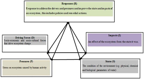
Figure A6. Summary of DPSIR framework analysis for land use/cover changes in Ethiopia CRV.
4. Conclusion and policy implications
4.1. Conclusion
Numerous studies related to LULC changes in Ethiopia have signposted that the country has experienced rapid and increasingly noticeable LULC changes since the late half of 20 century. Accordingly, this study also provided information on how land-use and land cover changed in CRV Ethiopia from 1985 to 2015. CRV Ethiopia is a home to many remarkable aquatic and terrestrial ecosystems but degradation of natural resources are firmly intertwined and expressed. Generally, rapid population growth, agricultural expansion, environmental fluctuations, degradation of natural resource and loss of biodiversity are the most visible socio-economic and environmental problem in the CRV area and all these put pressures on the water bodies (mainly on the four lakes, Ziway, Langano, Abijata and Shalla).
Landscape change as a result of LULC and simultaneous landscape pattern changes are on-going phenomena in the CRV area. This study also show that over the last 30 years’ period (1985 to 2015), major LULC changes were recorded in the CRV, mainly arable land expansion (small and large scale farming including irrigated agriculture) is noticed, reduction of natural vegetation is observed and also the water resources have been shrinking in size and depth significantly. More specifically, Lake Abijata showed a progressive decline by 25.9% resulting in severe degradation of the fragile ecosystems that have sustained the unique biodiversity (fauna and flora) for long. Consequently, the Abjiata-Shalla National Park is on the verge of collapse, the second episode of lake collapse in the nation next to Lake Haramaya if a serious measurement is not taken on time. These all consequences may alter the nutrient levels, water regime and related processes then may damage both aquatic and terrestrial biodiversity and reduce productivity unless restoration actions are taken soon sustainably. Further detailed study and quantification is still very important on biodiversity resource specific wise to pinpoint vulnerable species that need urgent conservation attention and design sustainable resource management strategy.
4.2. Policy implications
Based on the finding and DPSIR framework analysis, integrated land use and development planning and policy reform are suggested to encourage the on-going and planned ecosystem restoration, degraded land rehabilitation, and biodiversity conservation intervention in the CRV Lakes of Ethiopia via:
An effective water management plan and practice should be employed at the landscape level breaking down major river basin into sub-watersheds and prioritizing the sub-watershed for conservation and management based on degradation level.
Integrated land use and development planning should be done for the watershed prior to any developmental project being conducted in the area and must be preceded by a proper Environmental Impact Assessment (EIA) considering the impact on water resources,
Groundwater abstraction (the process of taking water from a ground source, either temporarily or permanently) is another problem since most water is used for irrigation or treatment. Depending on the environmental legislation (in Ethiopia), controls may be placed on abstraction to limit the amount of water that can be removed. Over-abstraction can lead to rivers drying up or the level of groundwater aquifers reducing unacceptably. Thus, the science of hydrogeology should be used to assess the safe abstraction levels.
Collaboration and commitment of the government with other stakeholders and working very closely with communities through participatory approach is an important way to reverse the current trend of LULC changes in the CRV area.
List of Abbreviations
| CRV | = | Central Rift Valley; |
| DPSIR | = | Driver, Pressure, State, Impact, and Response; |
| GCP | = | Ground Control Point; |
| LULCC | = | Land Use Land Cover change. |
Consent for publication
Not applicable
Cover image
Source: Author.
Availability of data and material
The data supporting the results presented in this study are available from the corresponding author upon reasonable request.
Authors’ contributions
All authors participated in conceiving, designing, and coordination. All the authors also involved to draft the manuscript as well as approved the final manuscript. Finally, all authors read and approved the final manuscript.
Acknowledgements
The authors gratefully acknowledge to Hamere Yohannes for her assistance in the GIS work and analysis and to the Ministry of Water and Irrigation for providing Rift valley basin GIS data and to all individuals, farmers and experts (development agents) who participated in this study by providing important information.
Additional information
Funding
Notes on contributors
Eyasu Elias
Eyasu Elias is an associate professor of Soil Science and a lecturer at center for environmental sciences, AAU. He has published extensively in reputable international journals in the area of soil science and environment and he is the sole author of the book recently published entitled, “Soils of the Ethiopian Highlands: Geomorphology and Properties”. WS, BT, and WG are a doctoral candidate in the Center for Environmental Science, College of Natural and computational sciences, Addis Ababa University, Ethiopia. WS and BT are lecturers at Selale University and Addis Ababa Science and Technology University, respectively. WG is a senior expert at Addis Ababa University – Horn of Africa Regional Environment Centre and Network.
References
- Alemayehu, T., Ayenew, T., & Kebede, S. (2006). Hydrogeochemical and lake level changes in the Ethiopian Rift. Journal of Hydrology, 316, 290–20. doi:10.1016/j.jhydrol.2005.04.024
- Amsalu, T., & Addisu, S. (2014). A review of wetland conservation and management policy in Ethiopian. International Journal of Scientific and Research Publications, 4(9), 656.
- Ariti, A. T., van Vliet, J., & Verburg, P. H. (2015). Land-use and land-cover changes in the central rift valley of Ethiopia: Assessment of perception and adaptation of stakeholders. Applied Geography, 65, 28–37. doi:10.1016/j.apgeog.2015.10.002
- Ariti, A. T., van Vliet, J., & Verburg, P. H. (2018). Farmers’ participation in the development of land use policies for the central rift valley of Ethiopia. Land Use Policy, 71, 129–137. doi:10.1016/j.landusepol.2017.11.051
- Assefa, E., & Bork, H.-R. (2016). Dynamics and driving forces of agricultural landscapes in Southern Ethiopia–A case study of the Chencha and Arbaminch areas. Journal of Land Use Science, 11, 278–293.
- Ayenew, T. (2002). Recent changes in the level of Lake Abiyata, central main Ethiopian Rift. Hydrological Sciences Journal, 47, 493–503. doi:10.1080/02626660209492949
- Ayenew, T. (2004). Environmental implications of changes in the levels of lakes in the Ethiopian Rift since 1970. Regional Environmental Change, 4, 192–204. doi:10.1007/s10113-004-0083-x
- Ayenew, T. (2007). Water management problems in the Ethiopian rift: Challenges for development. Journal of African Earth Sciences, 48, 222–236. doi:10.1016/j.jafrearsci.2006.05.010
- Ayenew, T. (2008). The distribution and hydrogeological controls of fluoride in the groundwater of central Ethiopian rift and adjacent highlands. Environmental Geology, 54, 1313–1324. doi:10.1007/s00254-007-0914-4
- Belete, M. D., Diekkrüger, B., & Roehrig, J. (2015). Characterization of water level variability of the main ethiopian rift valley lakes. Hydrology, 3, 1. doi:10.3390/hydrology3010001
- Berke, P., & Kaiser, E. J. (2006). Urban land use planning. University of Illinois Press, USA.
- Bewket, W., & Abebe, S. (2013). Land-use and land-cover change and its environmental implications in a tropical highland watershed, Ethiopia. International Journal of Environmental Studies, 70, 126–139. doi:10.1080/00207233.2012.755765
- Bryan, B. A. (2013). Incentives, land use, and ecosystem services: Synthesizing complex linkages. Environmental Science & Policy, 27, 124–134. doi:10.1016/j.envsci.2012.12.010
- Capistrano, D., Samper, C., Lee, M. J., & Raudsepp-Hearne, C. (2005). Ecosystems and human well-being: Multiscale assessments: Findings of the sub-global assessments working group of the millenium ecosystem assessment. Washington, DC, USA: Island Press.
- Collier, P., & Dercon, S. (2014). African agriculture in 50 years: Smallholders in a rapidly changing world? World Development, 63, 92–101. doi:10.1016/j.worlddev.2013.10.001
- Congalton, R. G. (1991). A review of assessing the accuracy of classifications of remotely sensed data. Remote Sensing of Environment, 37, 35–46. doi:10.1016/0034-4257(91)90048-B
- Costanza, R., de Groot, R., Sutton, P., Van der Ploeg, S., Anderson, S. J., Kubiszewski, I., … Turner, R. K. (2014). Changes in the global value of ecosystem services. Global Environmental Change, 26, 152–158. doi:10.1016/j.gloenvcha.2014.04.002
- CSA. (2013). Statistical Abstract: Ethiopian Central Statistical Authority. Addis Ababa Ethiopia.
- Daniel, A. M., Daniel, K. W., & Muluneh, W. (2012). Detection and analysis of land-use and land-cover changes in the Midwest escarpment of the Ethiopian Rift Valley. Journal of Land Use Science, 7, 239–260. doi:10.1080/1747423X.2011.562556
- Day, J. W., Jr, Arancibia, A. Y., Mitsch, W. J., Lara-Dominguez, A. L., Day, J. N., Ko, J.-Y., … Lomeli, D. Z. (2003). Using ecotechnology to address water quality and wetland habitat loss problems in the Mississippi basin: A hierarchical approach. Biotechnology Advances, 22, 135–159.
- De Groot, R., Brander, L., Van Der Ploeg, S., Costanza, R., Bernard, F., Braat, L., … Hein, L. (2012). Global estimates of the value of ecosystems and their services in monetary units. Ecosystem Services, 1, 50–61. doi:10.1016/j.ecoser.2012.07.005
- Demissie, F., Yeshitila, K., Kindu, M., & Schneider, T. (2017). Land use/Land cover changes and their causes in Libokemkem District of South Gonder, Ethiopia. Remote Sensing Applications: Society and Environment, 8, 224–230. doi:10.1016/j.rsase.2017.10.001
- Dimitriou, E., Karaouzas, I., Sarantakos, K., Zacharias, I., Bogdanos, K., & Diapoulis, A. (2008). Groundwater risk assessment at a heavily industrialised catchment and the associated impacts on a peri-urban wetland. Journal of Environmental Management, 88, 526–538. doi:10.1016/j.jenvman.2007.03.019
- Eshetu, A. A. (2014). Forest resource management systems in Ethiopia: Historical perspective. International Journal of Biodiversity and Conservation, 6, 121–131. doi:10.5897/IJBC2013.0645
- Gashaw, T., Tulu, T., Argaw, M., & Worqlul, A. W. (2017). Evaluation and prediction of land use/land cover changes in the Andassa watershed, Blue Nile Basin, Ethiopia. Environmental Systems Research, 6(1). doi:10.1186/s40068‐017‐0094‐5
- Gebreslassie, H. (2014). Land use-land cover dynamics of Huluka watershed, Central Rift Valley, Ethiopia. International Soil and Water Conservation Research, 2, 25–33. doi:10.1016/S2095-6339(15)30055-1
- Geheb, K., & Abebe, Y. D. (2003). Wetlands of Ethiopia: Proceedings of a seminar on the resources and status of Ethiopia’s wetlands. IUCN.
- Geist, H., McConnell, W., Lambin, E. F., Moran, E., Alves, D., Rudel, T. (2006). Causes and trajectories of land-use/cover change. In E. F. Lambin & H. Geist (Eds.), Land-use and land-cover change. Global change - The IGBP series. Berlin, Heidelberg: Springer.
- Giri, C. P. (2012). Remote sensing of land use and land cover change: Principles and applications. London, New York: Taylor and Francis Group.
- Girmay, G., Singh, B. R., & Dick, Y. (2010). Land-use changes and their impactson soil degradation and surface runoff of two catchmentsof northern Ethiopia. Acta Agriculturae Scandinavica, Section B – Plant Soil Science, 60, 211–226.
- Gong, J., Yang, J., & Tang, W. (2015). Spatially explicit landscape-level ecological risks induced by land use and land cover change in a national ecologically representative region in China. International Journal of Environmental Research and Public Health, 12, 14192–14215. doi:10.3390/ijerph121114192
- Haslam, S. M. (2004). Understanding wetlands: Fen, bog, and marsh. London and New york: CRC Press, Taylor and Francic Group.
- Hassan, A. A. M. (2013). Implementation of land-use-cover change analysis into megacity management response by using the DPSIR model. Geology Department, Faculty of Science, Cairo University, Aachener Geographische Arbeiten - 50 / 2013 S. 97 - 113.
- Hatch, N., & Wells, L. (2012). Multilevel environmental governance-the case of Ethiopian floriculture. Environmental Policy Update 2012: Development Strategies and Environmental Policy in East Africa.
- Hengsdijk, H., & Jansen, H. (2006a). Agricultural development in the central Ethiopian rift valley: A desk-study on water-related issues and knowledge to support a policy dialogue. Plant Research International BV, Wageningen, 22, 28–36.
- Hengsdijk, H., & Jansen, H. (2006b). Ecosystems for water, food and economic development in the Ethiopian central rift valley (BO-10-006-22). Report of inception mission to Ethiopia and Workplan.
- Houghton, R. A., House, J. I., Pongratz, J., Van Der Werf, G. R., DeFries, R. S., Hansen, M. C., … Ramankutty, N. (2012). Carbon emissions from land use and land-cover change. Biogeosciences, 9, 5125–5142. doi:10.5194/bg-9-5125-2012
- IPCC. (2013). Climate change 2013: The physical science basis. In T. F. Stocker, D. Qin, G. -K. Plattner, M. Tignor, S. K. Allen, J. Boschung, A. Nauels, Y. Xia, V. Bex and P. M. Midgley (Eds.), Contribution of working group I to the fifth assessment report of the intergovernmental panel on climate change (p. 1535). Cambridge and New York, NY: Cambridge University Press.
- Jansen, H., Hengsdijk, H., Legesse, D., Ayenew, T., Petra, S., & Petra, H. (2007). Land and water resources assessment in the Ethiopian central rift valley project: Ecosystems for water, food and economic development in the Ethiopian rift valley. Alteraw Wageningen, The Netherlands. Retrieved from http://www.alterra.wur.nl/
- Kabba, V. T. S., & Li, J. (2011). Analysis of land use and land cover changes, and their ecological implications in Wuhan, China. Journal of Geography and Geology, 3, 104. doi:10.5539/jgg.v3n1p104
- Kindu, M., Schneider, T., Teketay, D., & Knoke, T. (2015). Drivers of land use/land cover changes in Munessa-Shashemene landscape of the south-central highlands of Ethiopia. Environmental Monitoring and Assessment, 187, 452. doi:10.1007/s10661-015-4671-7
- Lambin, E. F., & Geist, H. J. (2008). Land-use and land-cover change: Local processes and global impacts. Springer Science & Business Media, Germany.
- Lambin, E. F., Geist, H. J., & Lepers, E. (2003). Dynamics of land-use and land-cover change in tropical regions. Annual Review of Environment and Resources, 28, 205–241. doi:10.1146/annurev.energy.28.050302.105459
- Lambin, E. F., Rounsevell, M., & Geist, H. (2000). Are agricultural land-use models able to predict changes in land-use intensity?. Agriculture, Ecosystems & Environment, 82, 321–331. doi:10.1016/S0167-8809(00)00235-8
- Lasanta, T., González-Hidalgo, J. C., Vicente-Serrano, S. M., & Sferi, E. (2006). Using landscape ecology to evaluate an alternative management scenario in abandoned Mediterranean mountain areas. Landscape and Urban Planning, 78, 101–114. doi:10.1016/j.landurbplan.2005.06.003
- Legesse, D., & Ayenew, T. (2006). Effect of improper water and land resource utilization on the central Main Ethiopian Rift lakes. Quaternary International, 148, 8–18. doi:10.1016/j.quaint.2005.11.003
- Lillesand, T., Kiefer, R. W., & Chipman, J. (2014). Remote sensing and image interpretation (6th ed.). John Wiley & Sons Inc., University of Widconsin-Madison.
- Ma, M. E. A. (2005). Ecosystems and Human Well-being: A Framework For Assessment. Washington: Island Press.
- Meshesha, D. T., Tsunekawa, A., & Tsubo, M. (2012). Continuing land degradation: Cause–Effect in Ethiopia’s central rift valley. Land Degradation & Development, 23, 130–143. doi:10.1002/ldr.1061
- Meshesha, T. W., Tripathi, S., & Khare, D. (2016). Analyses of land use and land cover change dynamics using GIS and remote sensing during 1984 and 2015 in the Beressa Watershed Northern Central Highland of Ethiopia. Modeling Earth Systems and Environment, 2, 168. doi:10.1007/s40808-016-0233-4
- Miheretu, B. A., & Assefa, A. Y. (2017). Determinants of farmers’ adoption of land management practices in Gelana sub‐watershed of northern highlands of Ethiopia. Ecological Processes, 6(19). doi:10.1186/s13717‐017‐0085‐5
- Mitsch, W. J., & Gosselink, J. G. (2000). The value of wetlands: Importance of scale and landscape setting. Ecological Economics, 35, 25–33. doi:10.1016/S0921-8009(00)00165-8
- Moges, D. M., & Bhat, H. G. (2018). An insight into land use and land cover changes and their impacts in Rib watershed, north‐western highland Ethiopia. Land Degradation and Development, 29, 3317–3330. doi:10.1002/ldr.3091
- Molla, M. B. (2015). Land use/land cover dynamics in the central rift valley region of Ethiopia: Case of Arsi Negele District. African Journal of Agricultural Research, 10, 434–449. doi:10.5897/AJAR2014.8728
- Mondal, P. P., & Zhang, Y. (2018). Research progress on changes in land use and land cover in the western Himalayas (India) and effects on ecosystem services. Sustainability, 10, 4504. doi:10.3390/su10124504
- MoWR. (2010). Rift valley lakes basin integrated resources development plan study project. Lake Hawassa Sub-Basin Integrated Watershed Management Feasibility Study. Main Report, 1.
- Muzein, B. S. (2006). Remote sensing & GIS for land cover/land use change detection and analysis in the semi-natural ecosystems and agriculture landscapes of the Central Ethiopian Rift Valley, Doctral desertation, Technische Universität Dresden Fakultät Forst- Geo- und Hydrowissenschaften Institut für Photogrammetrie und Fernerkundung, Dresden, Germany .
- National Research Council, N. (2014). Advancing land change modeling: Opportunities and research requirements. Washington, DC: The National Academies Press. ISBN 978-0-309-28833-0.
- Olaka, L. A., Odada, E. O., Trauth, M. H., & Olago, D. O. (2010). The sensitivity of East African rift lakes to climate fluctuations. Journal of Paleolimnology, 44, 629–644. doi:10.1007/s10933-010-9442-4
- Pandey, V. P., & Shrestha, S. (2016). Chapter 2 - DPSIR framework for evaluating groundwater environment. In S. Shrestha, V. P. Pandey, B. R. Shivakoti, & S. Thatikonda (Eds.), Groundwater environment in Asian cities: Concepts, Methods and Case Studies, 2016 (pp. 17–37). Butterworth-Heinemann an imprint of Elsevire (UK and USA). Retrieved from https://doi.org/10.1016/B978-0-12-803166-7.00002-7
- Peng, J., Xu, Y., Cai, Y., & Xiao, H. (2011). The role of policies in land use/cover change since the 1970s in ecologically fragile karst areas of Southwest China: A case study on the Maotiaohe watershed. Environmental Science & Policy, 14, 408–418. doi:10.1016/j.envsci.2011.03.009
- Phalan, B., Onial, M., Balmford, A., & Green, R. E. (2011). Reconciling food production and biodiversity conservation: Land sharing and land sparing compared. Science, 333, 1289–1291. doi:10.1126/science.1208742
- Pielke, R. A., Pitman, A., Niyogi, D., Mahmood, R., McAlpine, C., Hossain, F., … Fall, S. (2011). Land use/land cover changes and climate: Modeling analysis and observational evidence. Wiley Interdisciplinary Reviews: Climate Change, 2, 828–850.
- Raventós Vilalta, E. (2010). Water resources management in the central rift valley in Ethiopia. Universitat Politècnica de Catalunya, MSc Thesis in Civil Engineering, Barcelona, Spain.
- Rawat, J., & Kumar, M. (2015). Monitoring land use/cover change using remote sensing and GIS techniques: A case study of Hawalbagh block, district Almora, Uttarakhand, India. The Egyptian Journal of Remote Sensing and Space Science, 18, 77–84. doi:10.1016/j.ejrs.2015.02.002
- Ridgeley, R., Allnutt, T., Brooks, T., NcNicol, D., Mehlman, D., Young, B., & Zook, J. (2012). BirdLife International. 2012. Digital Distribution Maps of the Birds of the Western Hemisphere, Version, 5. Compiled by NatureServe, Arlington, Virginia, USA. Retrieved from http://www.natureserve.org
- Riebsame, W. E., Meyer, W. B., & Turner, B. (1994). Modeling land use and cover as part of global environmental change. Climatic Change, 28, 45–64. doi:10.1007/BF01094100
- Rogan, J., & Chen, D. (2004). Remote sensing technology for mapping and monitoring land-cover and land-use change. Progress in Planning, 61, 301–325. doi:10.1016/S0305-9006(03)00066-7
- Seyoum, W. M., Milewski, A. M., & Durham, M. C. (2015). Understanding the relative impacts of natural processes and human activities on the hydrology of the central rift valley lakes, East Africa. Hydrological Processes, 29, 4312–4324. doi:10.1002/hyp.10490
- Tadesse, L., Suryabhagavan, K. V., Sridhar, G., & Legesse, G. (2017). Land use and land cover changes and Soil erosion in Yezat Watershed, North Western Ethiopia. International Soil and Water Conservation Research, 5, 85–94. doi:10.1016/j.iswcr.2017.05.004
- Tefera, B., Ayele, G., Atnafe, Y., Jabbar, M. A., & Dubale, P. (2002). Nature and causes of land degradation in the Oromiya Region: A review. Socio-economics and Policy Research Working Paper 36ILRI (International Livestock Research Institute), Nairobi, Kenya, 82 pp.
- Tefera, M. (2011). Wildlife in Ethiopia: Endemic large mammals. World Journal of Zoology, 6, 108–116.
- Teka, K., Van Rompaey, A., & Poesen, J. (2013). Assessing the role of policies on land use change and agricultural development since 1960s in northern Ethiopia. Land Use Policy, 30, 944–951. doi:10.1016/j.landusepol.2012.07.005
- Teklemariam, D., Lanckriet, S., Azadi, H., Asfaha, T. G., Haile, M., Witlox, F., & Nyssen, J. (2017a). Effects of land deals on peak discharge and sediment transport in the catchments around the Grand Ethiopian Renaissance Dam. Land Degradation & Development, 28, 1852–1861. doi:10.1002/ldr.2654
- Tolessa, T., Senbeta, F., & Kidane, M. (2017). The impact of land use/land cover change on ecosystem services in the central highlands of Ethiopia. Ecosystem Services, 23, 47–54. doi:10.1016/j.ecoser.2016.11.010
- Vargas Amelin, E. (2016). Effects of climate change in Mediterranean water resources and their economic implications. Doctoral dissertation, UNED/Vrije Universiteit Brussel, pp. 257.
- Yohannes, H., Mohammed, A., & Elias, E. (2017). Land use/land cover dynamics and its impact on biodiversity resources in the Abijata Shalla National Park, central rift valley Lakes Region, Ethiopia. Environmental Science: An Indian Journal, 13, 152.
- Zeray, L., Roehrig, J., & Chekol, D. A. (2006). Climate change impact on Lake Ziway watershed water availability, Ethiopia, Catchment and Lake research. FWU Water Resources Publications, vol. 6, 18-23. ISSN:1613-1045.
Appendices
Table A1. Details of satellite data used for this study
Table A2. Description of LULC classes used to measure the changes in the periods 1985 to 2015
Table A3. Accuracy assessment of classified images
Table A4. Summaries of land use change area statistics for 1985 to 2015 reference years
Table A5. LULC changes for the periods 1985–1995, 1995–2015 and 1985–2015
Table A6. Annual change of LULC classes for the periods 1985–1995, 1995–2015 and 1985–2015
Table A7. Net and annual rate Changes in Area (km2) of the four lakes in the CRV for the periods 1985, 1995 and 2015
Table A8. The prime concerns to discourse as remedial action platform of the CRV Lake ecology