
 ?Mathematical formulae have been encoded as MathML and are displayed in this HTML version using MathJax in order to improve their display. Uncheck the box to turn MathJax off. This feature requires Javascript. Click on a formula to zoom.
Abstract
The adoption of Sustainable Land Management (SLM) depends, among others, on land fragmentation and soil characteristics. From the factors, land fragmentation is a worldwide trait that result from various institutional, political, historical, and sociological factors which influence farmers perceptionperception on SLM practice. Henceforth, this study was carried out to investigate the effects of land fragmentation and land quality on Sustainable Land Management (SLM) in the upper Lake Tana basin of Dera Woreda. Data on land fragmentation were collected using GPS and GIS tools, and a survey was conducted on 194 farm households, 1,059 parcels, and FGD to secure data on socioeconomic issues and insight of respondents on land fragmentation and associated variable. Simple descriptive and inferential statistics were applied to analyze socioeconomic, demographic and the perception of farmers about land-related factors. Analysis of land fragmentation using the Simpson index indicated 74%, implying that there is a high degree of land fragmentation in the study area. A multivariate probit (MVP) model was used to analyze the effect of land fragmentation and related factors on the interdependent investment decisions of SLM practices (Bunds, Manure, permanent erosion control and chemical fertilizer) using a multiple household level survey. The MVP model analysis indicates that farmers use two or more practices at plot level by considering substitution and complementarity effects of the practices. The results also revealed how land quality (e.g., slope and soil depth), land fragmentation (Simpson index, parcel size and distance from homestead) influence farmers’ investments in SLM practices. The overall results indicate that farm land fragmentation hinders SLM investments, and land quality parameters also improve or hinder the decisions about investments. Policy makers should consider these various land associated factors in designing and implementing SLM policies and programs.
Public Interest Statement
Land is an essential resource in farming. Its sustainable use is extremely affected by different factors. From the factors, land fragmentation is a universal attribute of all agricultural systems, which influence farmland SLM investment. In Northwestern highlands of Ethiopia, the demand for land has been rising significantly in the last three decades. Available evidence shows that, over the years, the total land holding per household is becoming smaller and smaller. Despite the clams that land fragmentation is a widespread phenomenon in Ethiopia. Land is a problematic economic resource in the study area due to fragmentation and loss of soil fertility. Thus, land consolidation/land amalgamation/land exchange policies should be backed up by a proper crop insurance scheme.
1. Introduction
Land is an essential economic resource in farming. Its sustainable utilization is extremely affected by different factors. From the factors, land fragmentation is a universal attribute of all agricultural systems, which influence farmland SLM investment. People use land for agricultural purposes in distinct plots in different areas. Land fragmentation is a phenomenon, which exists when a household operates a number of owned or rented non-contiguous plots at the same time (Wu et al., Citation2005). Fragmentation of agricultural land is widespread around the world and results from various institutional, historical and sociological factors, such as inheritance laws, collectivization and consolidation processes and transaction costs in land markets, urban development policies and personal valuation of land ownership (Blarel et al., Citation1992; Negash, Citation2013)
It is widely reported that in Asian and African countries the average land-holding size is remarkably small, and it is also highly fragmented (Demetriou, Citation2014). Thus, land fragmentation has an implication on agriculture productivity levels. In this regard, Korthals Altes and Bong Im (Citation2011) and Demetriou (Citation2014) admitted, particularly in developing countries including Ethiopia, that the level of rural land fragmentation plays a significant role in the national crop production as it affects both the environment of the rural ecology (i.e. sustainability of farm lands).
Different sustainable land management (SLM) technologies (manure, compost, permanent erosion control, bunds and chemical fertilizers) have been promoted to increase agricultural productivity. However, the adoption rates of these technologies are low (Kassie et al., 2009). This problem can be explained by the fact that investments in SLM practices are influenced and constrained by many land-related factors, institutional and socio-economic factors (Shiferaw et al., Citation2009). From those factors, land fragmentation and plot qualities are the important factors. Scholars also argue that if there is higher land fragmentation the implementation of soil and water conservation work is harder, the construction costs are higher, and more fencing is needed (Blarel et al., Citation1992) As a result of these problems, productivity decreases and hence the income of farmers also declines.
It is asserted that farm land fragmentation forms as one of the most important structural problems for hindering agricultural productivity in Ethiopia. Different research results in Ethiopia and elsewhere indicated that land fragmentation is often considered as handicap in SLM practice (Negash, Citation2013; Tenna et al., Citation2017). This is related to expenses due to losses on further transport cost (time), poor monitoring and the inability to use labor; hindering agricultural modernization and making it costly to modify adverse effects by consolidation schemes.
However, fragmented land with different biophysical conditions is described enabling farmers to minimize risks such as drought, flood and fire, diversify crop mixtures and ease seasonal labor bottlenecks (Tan et al., Citation2010). Land fragmentation also enables farmers to produce a widespread range of crops with different maturing (ripening) time so that they may focus their labor force at different plots during different times, thereby avoiding the period of labor intensity and household labor bottlenecks. Farmland fragmentation has become a serious problem, causing not only low crop production efficiency but also ecological damage and less sustainable management of farmlands in many parts of the world (Negash, Citation2013; Tan et al., Citation2010).
In northwestern highlands of Ethiopia, the demand for land has been rising significantly in the last three decades. Available evidence shows that, over the years, the total land holding per household is becoming smaller and smaller (Tenna et al., Citation2017). Despite the clams that land fragmentation is a widespread phenomenon in Ethiopia, there are not many studies conducted showing empirical evidence on the level of land fragmentation in different agro-ecologies, farming systems and landscapes using modern technologies such as GIS. Likewise, explicit empirical evidences on the implication of farmland fragmentation on sustainable land management are not well established for different upland and midland settings in the country in general and the ANRS in particular (Tenna et al., Citation2017).
Available studies (e.g., Negash, Citation2013; Tenna et al., Citation2017; Teshome et al., Citation2016) have attempted to capture variables such as SLM practices, and they tried to explain findings giving due focus in relation to land fragmentation and land quality parameters. Attempts to use modern GIS technologies to establish the location of fragmented farm land holdings are either rare or not systematically done. According to participatory rural appraisal report of Dera Woreda held by CASCAPE, land is a problematic economic resource in the study area due to fragmentation and loss of soil fertility. So, the inclusion of a number of variables helps to produce tangible facts on farmland fragmentation that are potentially useful to initiate land consolidation policy initiatives across the region and the nation at large.
In light of this, this study was conducted in 13 sub watersheds (Fogeda, Mosha, Enkulal, Gidib, Kegawuha, Awrarit, Endalmot, Gumara, Agonafir, Shibirila, ArbGebeya, TimiketeBahir and Chan) found in the upper Lake Tana basin of Dera Woreda, South Gonder and characterized by small farm holdings divided into small strips scattered over distant areas (DWNRMO, Citation2018). This research aims to produce empirical evidences on the effects of farm land fragmentation and plot quality on sustainable land management. The research, therefore, attempts to establish empirical evidence on the level of land fragmentation using GPS and GIS technologies. It also examines how farmers and experts feel about the effect of land fragmentation on SLM.
2. Literature review
The scope of most economic evaluation of land fragmentation is narrowly focused in the sense that efficiency analysis is often limited to one or few aspects of production. Clearly, such approaches are likely to underestimate (or overestimate) farm efficiency, particularly in areas that are characterized by mixed farming, i.e., simultaneous production of crops, vegetables and fruits, as well as animal husbandry. In this regard Rosset (Citation2000) demonstrated evidently that small farms, often characterized by land fragmented, are more productive, more efficient and able to contribute more to economic development than large farms if efficiency measurement involves total output than a single crop, namely, the output of all crops on a designated plot—including various grains, fruits, vegetables, fodder and animal production. Di Falco et al. (Citation2010) concluded that farm fragmentation is positively correlated with the number of crops (farm-biodiversity) which, in turn, is positively correlated with farm profitability. On the other hand, Del Corral et al. (Citation2011) identified that profit in the Spanish dairy farms increases in the range between 9.4% and 14% owing to land consolidation program.
Three dominant prescriptions are proposed by authors, regardless of their positive, negative or ambiguous evidences. The first policy prescription emphasizes on creating off-farm and nonfarm employment opportunities. The rationale is that doing so will reduce pressure on land and retard further land fragmentation (Blarel et al., Citation1992; Wu et al., Citation2005; Tan et al., Citation2006; Niroula and Thapa, Citation2007 and Rahman and Rahman, Citation2009). The second prescription emphasizes on promoting rural markets, particularly land, labor, food and credit markets (Di Falco et al., Citation2010; Tan et al., Citation2006).
Holden et al. (Citation2014) demonstrated that promoting the non-land market alone could ensure production efficiency without the need for land market. They argued that the standard neoclassical household model can give efficient outcomes even without land market, given the non-land factor markets function appropriately. Thus, promoting not only the land market but also the non-land factor market alone can enhance productivity. Similarly, it is argued that the availability of such markets can enhance “the ability of farmers to adjust optimally the extent of fragmentation (or consolidation) of their holdings over time” (Holden et al., 2012).
The third dominant prescription is based on the belief that factor markets can correct the side effects of land fragmentation; and that it demands limited government intervention; Examples include Nguyen et al. (1996) and Rahman and Rahman (Citation2009), who asserted that land fragmentation is costly and detrimental to productivity, Niroula and Thapa (Citation2007), who argued that the implication of land consolidation is not clear, and Blarel et al. (Citation1992) and Di Falco et al. (Citation2010), who asserted that land fragmentation is beneficial for risk management and crop diversity. All, however, ended up recommending less (modest) government intervention.
4. Materials and methods
4.1. Study sites
This study was carried out in the upper Lake Tana basin of Dera Woreda, Amhara region, Ethiopia. Dera is a part of the south Gonder zone and is bordered to the south by the Abay River, which separates it from east Gojjam. It is bordered by Lake Tana to the west, to the north by Fogera and to the east by Estie Woreda. In geographical coordinate terms, the Woreda is located in 12◦83׳80״N latitude and 35◦52׳00״E longitude (Figure ).
Figure 1. Map of study area.
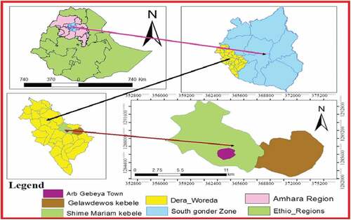
The Woreda covers a total area of 158,948 ha, of which 35% is plain, 20% is mountainous, 18% is gorge and valley and 27% is undulating. There are 32 kebeles (administrative villages) in the Woreda, of which 29 are rural kebeles and 3 are town kebeles (Woreda Office of Agriculture, Citation2018). This study used a statistical representation of the upper Lake Tana basin of Dera Woreda households. In the study area, there are six rural kebele administrations, namely Gelawdewos, Dereba, Wutmera, ArbGebeya, Degone and ShimeMaryam. From the total Kebele administrations, this study was carried out in three Kebeles namely Gelawdewos, ArbGebeya and ShimeMaryam.
5. Gelawdewos kebele
The total area covered by the kebele is estimated to be 3,744 ha, of which 2,821 ha is arable land, 135 ha is grazing land, and 650 ha is forest. The topography of the kebele comprises 25% plain, 60% undulating, 5% gorge and valley and 10% mountainous. The total population of the kebele is 7,338 of which 3,793 are male and 3,545 are female. The number of households in the kebele is estimated to be 1,616 of which 1,411 are male headed and 205 are female headed. The maximum and minimum temperatures of the kebele are 25°C and 18°C, respectively, and the average annual rainfall is 1,250 mm. The altitude range of the kebele is 2,200 to 2,600 m above sea level (Office of Woreda Agriculture, 2018).
6. Shime kebele
The total area covered by the kebele is estimated to be 3,054 ha of which 2,729 ha is arable land, 79 ha is grazing land, 80 ha is forest, 45 ha is gully and gorge and 121 ha is settlement. The topography of the kebele comprises 20% plain, 65% undulating, 5% gorge and 10% mountainous. The number of households in the kebele is estimated to be 2,520 of which 2,128 are male headed and 392 are female headed. The total population of the kebele is 14,125 of which 8,005 are male and 6,120 are female. The temperature of the Shimekebele ranges from 23°C to 13°C (DWAO, 2018).
7. ArbGebeya town
The total area covered by the kebele is estimated to be 2,100 ha of which 1,575 ha is arable land. The topography of the kebele comprises 21% plain, 64% undulating, 6% gorge and 9% mountainous. The number of households in the kebeleis is estimated to be 3,525 of which 2,820 are male headed and 705 are female headed. The total population of the kebele is 15,224 of which 12,180 are male and 3,045 are female. The temperature of the Shime kebele ranges from 24°C to 14°C (DWAO, 2018).
7.1. Research design
This study aims to investigate the level of land fragmentation using GIS, associated causes and land fragmentation effects on SLM. To achieve the objectives of the study, both primary and secondary data were used. The primary data was generated through information gathering from involving rural households, Key informants (i.e. Kebele leader) and government staff working at kebele levels and also through farm plot location measurements. Secondary data was collected from relevant literature and government and non-government reports.
As this research examined the perceptions and attitude of households, community groups and government institutions, a cross-sectional research design/survey design was used to generate appropriate information. A cross-sectional design requires the collection of data on many cases and at a single point in time in order to gather a body of quantitative data in connection with two or more variables, which are then examined to find out patterns or associations (Bryman, Citation2016). To enhance generation of reliable data for analysis, the research design should be complemented by proper research methods, that is, techniques for data generation and collection.
Taking note of this and considering the nature of this research, broad base information was required to address the stated research objectives. A combination of qualitative and quantitative components is one of the most effective methods for evaluation researches.Thus, in this study, both qualitative and quantitative research methods were used as a research approach. Qualitative method was used to collect data on the perception of farmers and government staff on land level of fragmentation and its effect on SLM. Accordingly, in the process of data generation, multiple sources of evidence such as survey questionnaire, semi-structured interviews (group discussions and in-depth interviews with key informants) were used to collect primary data and a survey of grey literature was conducted for organizing secondary data.
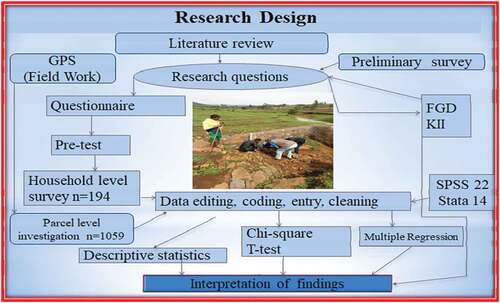
Spatial data collection for land fragmentation was applied using GIS tools such as GPS and Google maps to show the location of study kebeles and fragmented parcels and how far each parcel is located from homestead. The overall data collection method and procedure practiced is indicated in Figure and in the following sections.
Figure 2. Research design.
7.2. Selection of study localities, sampling techniques and procedures
This study used a statistical representation of the upper Lake Tana basin of DeraWoreda households. In the study area, there are six rural kebele and one town administrations, namely Gelawdewos, Dereba, Wutmera, Degone, ShimeMaryam, Huletu-Wogedamie and ArbGebeya. From the total Kebele administrations, this study was carried out in three Kebeles namely Gelawdewos, ArbGebeya and ShimeMaryam. These kebeles were selected randomly since all the kebeles are similarly characterized by small farm holding divided into small strips scattered over distant areas. Household heads were a source of data on socioeconomic and land fragmentation and land management issues. The list of households having land and kept in the Kebele administration together with the number of farm plots held by each household was used as sampling frame shown in Figure .
Figure 3. Sampling technique and procedures.
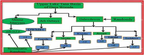
As Kebles are large they are subdivided in to sub watershed to easily locate each sample household. The households in the watershed were grouped by considering the number of parcels they have. The households used in this study were grouped as households with 1–2 parcels, 3 to 5 parcels, 6–8 parcels and more than 8 parcels. Sample households were selected using proportional sampling method considering the number of households in each parcel group. Accordingly, the total sample households were 194; sample households in Gelawdewoskebele 75 and sample households in Shime kebele (61) and ArbGebeya (58) were selected. The number of male headed and female headed sample households was also fixed as per the data kept in the Kebele to make sure that the perception of male and female headed households is included.
The sample size was determined by using Yamane, (Citation1967) formula as indicated below.
Where n is the sample size needed, N designates the total number of household heads in the upper Lake Tana basin of 13 SWS, and e is the desired level of precision (e = 7%).
Accordingly,
The study was therefore, conducted in 13 sub-watersheds, including under three kebeles, which are relatively located with high population pressure and fragmented land-holding size. These are Fogeda, Mosha, Enkulal, Gidib, Kegawuha, Awrarit, Endalmot, Gumara, Agonafir, Shibirila, ArbGebeya, Timikete Bahir and Chan, they are located under the Upper Lake Tana Basin.
The sample households (194) were proportionally distributed across the study kebeles considering the population of households in each kebele. Accordingly, of the 194 total sample households 75 were selected from Gelawdewos kebele, 61 from Shime kebele and 58 from ArbGebeya kebele. The number of male headed and female headed sample households was also fixed as per the data kept in the Kebele to make sure that the perception of male and female headed households is included.
8. Results
8.1. Sustainable land management investments
The study results show that the implementation of SLM technologies or practices is moderate in the study area. On average at household level, farmers covered 49.5% of their plot with bunds, applied 264.64 kg fertilizer (Di-Ammonium-Phosphate (DAP) and urea) and covered 87.6% of their plot. It is very difficult to know the amount of manure farmers use at household level because farmers apply manure daily on a plot adjacent to the homestead from the stables. However, from the total households around 55.2% were manure users and applied on about 23.6% of their plot. Intensity of SLM investment at HH and plot level is indicated in Table .
Table 1. Intensity of SLM investments at household level and plot level
Responders acknowledged that application of manure is an age-old practice used by most farmers in the watershed areas. Apart from using it for soil fertility management purposes, it is also widely used as household fuel for cooking and keeping the house warm.
8.1.1. Reasons for land fragmentation
According to the conducted Focus group discussions and KIIs revealed it is reported that the rate of land fragmentation in the VDCs has been increasing. Inheritance and rapid growth of population were mentioned as the main reason for land fragmentation in the study kebeles. Unless the legal provision on inheritance is complemented by rules and regulations inhibiting further division of parcels without compromising the land right of farmers, the problem of land fragmentation is likely to continue unabated. .
High rate of population growth and legal provision based on inheritance division and land tenure systems are responsible for land fragmentation in the study area. Inheritance and rapid growth of population is the main reason for land fragmentation.
8.1.2. Sustainable land management investment and land related factors
Different sustainable land management (SLM) technologies (bunds, manure/compost PEC and chemical fertilizers) have been promoted to increase agricultural productivity. However, the adoption rates of these technologies are low. This problem can be explained by the fact that investments in SLM practices are influenced and constrained by many land related, biophysical, institutional and socio-economic factors as argued by AkaluTeshome et al. (Citation2016).
Sustainable land management investments are shaped by land quality, that is, soil fertility, soil depth, soil type and slope level. This is due to the fact that the effects of soil erosion and hence SLM practices vary according to the land quality (AkaluTeshomeet al., 2014). Land quality is a central issue for questions related to SLM investment. Investments in SLM are therefore undertaken to improve the land quality and consequently to increase production and productivity. Land quality, as used in the context of this research, refers to soil fertility, soil depth, soil type and slope level of a plot of land. Land quality is assessed qualitatively by farmers. Farmers mostly use crop productivity as a proxy for land quality (AkaluTeshome et al., 2014).
8.1.3. Independent sample t-test on demographic and land fragmentation parameters
Age: is one of the independent variables related to SLM investment and expected to determine successful implementation of SLM practice. The average age of the whole sampled household heads was 49.31 years with the minimum and maximum ages of 25 and 86 years, respectively. The average household age of manure, bund and PEC and fertilizer users was 47.27, 49.02, 46.02 and 47.5, respectively. On the other hand, the 51.64, 50.05, 48.8 and 51.7 years of mean age of nonuser, based on the above sequence, with mean difference significant at 5% probability level on manure and PEC investment, is highly significant on chemical fertilizer. However, independent sample t-test indicated no significant mean differences even at 10% probability level for bund. In all SLM investment practice, the mean age of the user is lower than the non-user.
Labor intensity: The average labor intensity of the sample households was 4.79, the maximum labor intensity was 9.5, and the minimum was 1.75. The average LI of users was 5.02, 4.6, 4.878 and 4.6, while that of nonusers was 4.5, 4.89, 4.74 and 5.3 for manure, bund, PEC and chemical fertilizer, respectively. With mean difference significant at 1% probability level for manure, bund and chemical fertilizer independent sample t-test indicated no significant mean differences for PEC. As indicated in Table , households with larger labor intensity practice manure SLM investment better than non-users. HHs with lower labor intensity participate in bund and chemical fertilizer application.
Table 2. Independent sample t-test on demographic and land fragmentation parameters
Total area: The average landholding of the sample households is 1.53 ha. Total farm size varies between 0.36 and 3.75 ha. There is a considerable variation in land holding among the sample households. This showed that there was an inequality in holdings among farm households. This land-holding inequality among the community may increase tenure insecurity. During the group discussions and key informant interview, farmers pointed out that young farmers and other landless people have no chance of obtaining land because of the prohibition of land redistribution since 1999.
Number and distances of parcels: The number of parcels, size of parcels and distance of parcels from homestead are good indicators of land fragmentation. The sample households as a whole managed parcels 1059 in 2018/19. On average, households managed 5.46 parcels in different locations. Distance of parcels from home is also one of the important factors in analyzing land fragmentation. The distance of a parcel from a homestead is described in three ways. One of the estimated times needed by an adult person to walk from homestead to parcel (walk minutes). In this measurement, homestead to parcel distance range from 2 to 40 min with an average of 12.29 min. The other is air distance by using GPS and GIS technology, according to this the average air distance is equal to 0.52 km and this is lower as compared to actual distance (0.94943) perceived by the farmer due to up and down topography of the study area.
Distance in km is statistically significant at 1% level on the variable manure and chemical fertilizer. The parcels near to the homestead are highly managed by the farmer. Households investing in manure have significantly shorter average parcel distances from home than non-investing households. Households investing in fertilizer have significantly longer average parcel distances from home than non-investing households. On the other hand, households with lower land fragmentation index are fertilizer users than non-investing at 1% probability level.
8.1.4. Land quality characteristics
The land holdings of sample households in study watersheds were assessed qualitatively to know the quality of their parcels. In total, 1059 parcels owned by 194 HH were investigated. The results of the study show that farmers have parcels with different soil type, slope class, soil depth and fertility status. This is mainly due to the land distribution and redistribution policy of the last two consecutive governments to bring land quantity and quality equity at the community level. Farmers partly associate soil color with soil fertility and the degree of soil erosion. They are able to relate changes in color to the removal of top soil by erosion. According to farmers, a black color is an indicator of a fertile soil; a yellowish color is an indicator of an eroded soil considered as bad land. The parcels of all the watersheds are dominated by brown soils (447 plots = 38.4%) and followed by black soils (25.8%).
Moreover, the slope of their parcels influences farmers’ decisions to control soil erosion. The farmers identified 41.3%, 28.3% and 30.4% of the parcels as belonging to the slope categories flat, medium and steep slopes, respectively. This suggests that a large number of parcels 58.7 (steeper and moderate parcels) in the study areas are exposed to erosion and that soil erosion is recognized as a severe problem in the study areas. Thus, sustainable land management practices are essential to improve the land quality. Farmers also classify their parcels on the basis of soil depth. Accordingly, about 27.8%, 28.6% and 43.6% of the parcels are considered to be shallow, medium and deep, respectively.
As indicated in Table , there is a significant association between the color of plots and SLM investment. The chi-square test analysis indicates a significant association between soil color and investments in bunds and chemical fertilizer. Farmers invest in SLM practices mostly on parcels with brown and red soils. Investments in SLM practices on plots with black soils are very low in intensity but not in number because of certain bio-physical (high fertility) characteristics. The result agreed with Akalu Teshome et al. (Citation2016). These results show that the soil type influences the farmers’ behavior in SLM investments shown in Table .
Table 3. Chi-square on land quality characteristics and ownership status
Table 4. Multivariate probit estimations for effects of land fragmentation on SLM
The study results also reveal that there are significant associations between slope status and investment in manure, bunds and permanent erosion control. Farmers construct bunds and PEC mainly on steep land and to some extent on moderate plots to control the soil erosion problem. This is because parcels with steep slopes are highly vulnerable to erosion. The results indicate that farmers apply chemical fertilizer irrespective of the slope classes. This showed that farmers are applying fertilizer just to increase production and productivity. The results further showed that there were also significant associations between soil depth and investment in bunds, manure, PEC and chemical fertilizer.
Farmers construct PEC mostly on parcels with shallow soil and then construct bunds on parcels with moderate soil depth. This indicates that farmers construct bunds and PEC to avoid a further decline of the soil depth. There is a statistically significant association on over all SLM practice and soil depth. Systematic associations are also observed between soil fertility status of parcels and investments in bunds and PEC. Farmers are mainly investing bunds and PEC in medium fertile parcels to improve or sustain the soil fertility. On the other hand, the results indicate that farmers apply chemical fertilizer in the overall soil fertility status. This showed that farmers are applying fertilizer just to increase production and productivity without considering the soil fertility even if the intensity is different.
8.1.5. Tenure arrangements and sustainable land management
The study identified significant differences in SLM investment among different tenure arrangements (Table ) aligned with this, the Chi-square test indicates that there is a logical relationship between the application of long-term investments (manure, bund and PEC) and tenure arrangements. This shows that farmers already having land-holding certificates give more attention to their parcels for the long-term investments (bund, manure and PEC). However, the application of fertilizer is relatively the same for the different tenure arrangements. This is because the farmers get land in the form of a share in/rent for a short period of time, and thus, the leases or the renters do not feel secure to apply long-term investments.
8.2. Multivariate probit estimations for effects of land fragmentation on SLM
The Wald test (χ2 (44) = 732.83, p = 0.000) indicates that the subset of coefficients of the model is jointly significant and that the explanatory power of the factors included in the model is satisfactory; thus, the MVP model fits the data reasonably well. The results of likelihood ratio test in the model (LR χ2 (6) = 63.81, χ2 > p = 0.0000) indicating the null that the independence between SLM choice decision (ρ21 = ρ31 = ρ41 = ρ32 = ρ42 = ρ43 = 0) is rejected at 1% significance level. There are significant joint correlations for two estimated coefficients across the equations in the model (Table ). This verifies that separate estimation of choice decision of these SLM practice is biased and the decisions to choose the four SLM practice are interdependent household decisions. Hence, there are differences in SLM practice selection behavior among the farmers, which are reflected in the likelihood ratio statistics. Separately considered, the ρ values (ρij) indicate the degree of correlation between each pair of dependent variables.
Table 5. Estimated correlation matrix
The ρ41 (correlation between the choice of chemical fertilizer and manure) is negatively interdependent and significant at 1%. On the other hand, the correlation between permanent erosion control and bund is positively interdependent and statistically significant at 1% probability level. This finding leads to conclude that farmers applying manure to their plot are less likely to apply chemical fertilizer for that plot (ρ41). The study reveals that manure and fertilizer are substituting each other in the farming system of the study areas. However, bunds have no substitution and/or complementary effect with manure/compost and fertilizer. On the other hand, farmers applying PEC to their plot are likely to apply bund. Both bund and PEC SLM practices depend on slopes, and they are complementary to each other.
The Simulated Maximum Likelihood (SML) estimation results show that the probability that farmers choose manure/compost, bund, PEC and chemical fertilizer were 22.9%, 49.11%, 23.92% and 87.63%, respectively. This indicates that the likelihood of choosing manure/compost is relatively low as compared to choosing PEC (23.917%), bund (49.11253) and chemical fertilizer (87.63%). The joint probabilities of success or failure of the four SLM practice also suggest that households are less likely to jointly choose the four SLM practice. The likelihood of households to jointly choose the four SLM practice to each plot simultaneously is 2.44%, their failure to jointly choose the four SLM practice simultaneously is 3.1%. The reason behind this is the substitutable nature of the two SLM.
Based on the result of MVP model, five of the variables out of eleven variables used in the model were significant at more than one SLM practice, while four variables were significant in only one SLM practice. Out of eleven explanatory variables included in the model, four variables affected significantly manure application of that plot; four variables significantly affected bund; four variables significantly affected PEC and five variables significantly affected chemical fertilizer at different probability levels.
The distance of the plot from the homestead: It is negatively associated with the likelihood of farmers applying manure/compost and bund at 1% and 10% significant level, respectively. It reflects that in plots located far away from homestead, households face difficulty in applying manure/compost and bund. This implies that long distance across locations lead to considerable travelling time between parcels and higher transport costs. Plots in shorter distances from home are likely to get manure/compost application. This is because compost and manure are very bulky to transport, and thus, it is very difficult to apply them on distant plots. However, there is no significant association between parcel distance from home and PEC. This result is similar to the findings of Akalu Teshome et al. (2014).
On the other hand, this variable is highly significant and positively associated with the likelihood of farmers applying chemical fertilizer. Since compost and manure are very bulky to transport, and thus, it is very difficult to apply them on distant plots, the farmer alternatively applies chemical fertilizer for the distant plot in the same manner. The independent sample t-test also shows that the mean distance of plots applied with chemical fertilizer is double as compared to the other plots. Due to this justification, this variable is negatively associated with manure/compost and positively with chemical fertilizer.
Land fragmentation index (Simpson index): It is negatively associated with the likelihood of farmers applying chemical fertilizer at 5% significant level. This means that farmers less likely prefer what and apply chemical fertilizer for the plots with small strips (larger LFI). On the other hand, farmers more likely prefer to apply chemical fertilizer for the plots with large area, since the larger owned plots minimize the fragmentation index. This result agrees with the earlier findings of Winters et al. (Citation2002).
Farm Size: Farm size is positively associated with the likelihood of PEC and manure/compost at 5% and 10% probability level in the study area, and this implies that users of PEC and manure were those with large farm sizes. This finding agrees with the result of Awoyinka et al. (Citation2009).
Slope status of the plot: Topography of farmland, as farm level factors, is positively associated and highly significant at 1% with the likelihood of farmers’ use of bund and PEC. The result agrees with earlier findings of Awoyinka et al. (Citation2009) where bund and PEC are identified as the best practice for hilly farmlands, especially when a large hectare is being cultivated. The result also agrees with the findings of Winters et al. (Citation2002) who reported that the slope of farmland is positively associated with bund and PEC practice.
Labor Intensity: It is negatively associated with the likelihood of farmers applying chemical fertilizer and bund at 1% significant level. The negative relation indicates those farmers who were chemical fertilizer user are with lower labor intensity since they can’t prepare the manure/compost alternative (requires higher labor force to prepare and transport). Thus, farmers with higher labor intensity are less likely to choose chemical fertilizer; rather they try to use manure/compost instead of chemical fertilizer with a minimum cost.
Soil depth: It is negatively associated with the likelihood of farmers applying PEC at 1% probability level. This indicates that as the soil depth increases from shallow-to-moderate-to-deep, farmers are less likely to choose PEC. This result is in conformity with the findings of Winters et al. (Citation2002), Awoyinka et al. (Citation2009) and Babalola and Olayemi (2013).
Age: It is negatively associated with the likelihood of farmers applying manure and chemical fertilizer at 1% probability level. This indicates that as the age of the farmers increases they become weak and unable to prepare compost and face difficulty to transport manure since it is bulky in nature. This result suggests that older farmers are less likely to invest in manure. This can be explained by the fact that older farmers have a short planning horizon compared with younger colleagues. This is in line with the findings of Anley et al. (Citation2007) and Akalu Teshome et al. (2014). On the other hand, from the semi-log function, age affects productivity negatively, and this leads to cash shortage and poor capacity of households to use chemical fertilizer.
9. Conclusions and recommendations
9.1. Conclusions
From the result, it could be concluded that there is a high degree of land fragmentation in the study area, which has a negative effect on bund and PEC practices. Land fragmentation increases both travelling time and cost of traveling between plots, hence raises the transport cost for inputs and outputs. The study also revealed that manure and fertilizer are substituting each other (often not used together) in short distant plots in the farming system of the study areas. However, bunds have no substitution or complementary effect on manure and fertilizer application. This indicates the interdependence between the different investment decisions of SLM practices. A single equation adoption model does not give information about this interdependence between SLM practices. The study shows a significant difference in SLM investment among different land fragmentation parameters. The results of the econometric analysis indicate that land fragmentation and land quality parameters are important factors that affect the probability of investing in SLM practices. Thus, matching SLM practices with land fragmentation and land quality is of paramount importance for facilitating the decision-making about and adoption of SLM investments. The study also revealed that the current level of farm land fragmentation is very high, and it affects SLM investments.
9.2. Recommendations
Following the findings obtained from this study, the following issues are forwarded as a recommendation. There is a need for urgent land reform policies and programs that would give farmers access to more contiguous land holdings for increased agricultural production and SLM investment. On the other hand, farmers prefer to some extent fragmented land, with different types of parcels, to minimize agricultural production risks.
Thus, land consolidation/land amalgamation/land exchange policies should be backed up by a proper crop insurance scheme. We did not say anything about crop insurance, so we cannot recommend this!!
The overall results indicate that farm land fragmentation hinders SLM investments, and land quality parameters also improve or hinder the decisions about investments. Policy makers should consider these various land associated factors in designing and implementing SLM policies and programs.
Acknowledgements
First of all, I am very grateful to Tadesse Amsalu (Associate Professor) and Zewdu Berhanie (PhD), my advisors, for fascinating guidance, thought-provoking suggestions, encouragements and patience during my thesis writing. I had such a wonderful privilege of working with you, and I hope this is only the beginning.
Secondly, I am highly encouraged to gratitude my sponsors Bahir Dar University Institutional University Cooperation (BDU IUC) and Belgian VLIR-UOS project for financing the research project, without finance, no one can pass even shelf and Habtamu Assaye Ph.D. Candidate) who generally took part in sharing and views in field works. I would like to warmly acknowledge program manager of BDU IUC Enyew Adigo (Professor) and Land resilience project team leader Alemayehu Wassie (Ph.D. for their encouragement. I am also greatly thankful to my family and friends who have been encouraging me during this thesis preparation highly during my filed GPS data collection. I thank you all, again.
Forwarding the entire above, I hope that my humble gratitude reaches Almighty GOD who likes me made all my supporters on the way.
Disclosure statement
The authors have not declared any conflict of interest.
Additional information
Funding
Notes on contributors

Gebreegziabher Fentahun
Gebreegziabher Fentahun was born on 8 November 1994 in Pawi Woreda near to Gilgel Beles town in Benishangul Gumuz Region, Ethiopia. He attended his Primary (1–8), Secondary (9–10) and Preparatory education (11–12) at V127 Primary School, Manbuk Senior Secondary School and Manbuk Preparatory School, respectively. Then after, he joined Wollo University in 2013 and graduated with Bachelor of Science in Agricultural Economics with Very Great Distinction and being Gold Medalist among the whole College Graduates in 2016. Soon after graduation, he worked as a Graduate Assistant Lecturer in Assosa University, Department of Agro Economics for a year. Later, he joined the Graduate Program at Bahir Dar University in 2017 to pursue his study for Master of Science Degree in Agro Economics and graduated with Master of Science in Agro Economics with Excellent Distinction in July 2019. After the accumulation of master degree He joined Bahir University College of Agriculture and Environmental Science as Lecturer in Department of Agricultural Economics.
References
- Anley, Y., Bogale, A., & Haile‐Gabriel, A. (2007). Adoption decision and use intensity of soil and water conservation measures by smallholder subsistence farmers in Dedo district, Western Ethiopia. Land degradation & development, 18(3), 289–20.
- Awoyinka, Y. A., Akinwumi, J. A., Okoruwa, V. O., & Oni, O. A. (2009). Effects of livelihood strategies and sustainable land management practices on food crop production efficiency in South-West Nigeria. Agricultural Journal, 4(3), 135–143.
- Bezu, S., & Holden, S. (2014). Demand for second-stage land certification in Ethiopia: Evidence from household panel data. Land Use Policy, 41, 193–205.
- Blarel, B., Hazell, P., Place, F., & Quiggin, J. (1992). The economics of farm fragmentation: Evidence from Ghana and Rwanda. The World Bank Economic Review, 6(2), 233–254. https://doi.org/10.1093/wber/6.2.233
- Bryman, A. (2016). Social research methods. Oxford university press.
- Bureau of Rural Land Administration and Use (BoRLAU/DWNRMO). 2018. Yebahir Mezigeb manual on Land holding and plot characteristics for the rural kebeles of Dera Woreda, Anbessamie, Ethiopia.
- Del Corral, J., Perez, J., & Roibás, D. (2011). The impact of land fragmentation on milk production. Journal of Dairy Science, 94(1), 517–525. https://doi.org/10.3168/jds.2010-3377
- Demetriou, D. (2014). Land fragmentation the development of an integrated planning and decision support system (IPDSS) for land consolidation (pp. 11–37). Springer.
- Di Falco, S., Penov, I., Aleksiev, A., & Van Rensburg, T. M. (2010). Agrobiodiversity, farm profits and land fragmentation: Evidence from Bulgaria. Land Use Policy, 27(3), 763–771. https://doi.org/10.1016/j.landusepol.2009.10.007
- Di Falco, S., Penov, I., Aleksiev, A., & Van Rensburg, T. M. (2010). Agrobiodiversity, farm profits and land fragmentation: Evidence from Bulgaria. Land use policy, 27(3), 763–771.
- Korthals Altes, W. K., & Bong Im, S. (2011). Promoting rural development through the use of land consolidation: The case of Korea. International Planning Studies, 16(2), 151–167. https://doi.org/10.1080/13563475.2011.561060
- Lamola, A. A., & Yamane, T. (1967). Sensitized photodimerization of thymine in DNA. Proceedings of the National Academy of Sciences, 58(2), 443–446.
- Negash, S. A. (2013). Economics of land fragmentation: Effects on productivity, technical efficiency and crop diversity in Tigray, Northern Ethiopia. Norwegian University of Life Sciences, Ås.
- Niroula, G., & Thapa, G. B. (2007). Impacts of land fragmentation on input use, crop yield and production efficiency in the mountains of Nepal. Land Degradation & Development, 18(3), 237–248. https://doi.org/10.1002/ldr.771
- Parikh, A., & Shah, K. (1994). Measurement of technical efficiency in the north‐west frontier Province of Pakistan. Journal of Agricultural Economics, 45(1), 132–138.
- Rahman, S., & Rahman, M. (2009). Impact of land fragmentation and resource ownership on productivity and efficiency: The case of rice producers in Bangladesh. Land Use Policy, 26(1), 95–103. https://doi.org/10.1016/j.landusepol.2008.01.003
- Rahman, S., & Rahman, M. (2009). Impact of land fragmentation and resource ownership on productivity and efficiency: The case of rice producers in Bangladesh. Land use policy, 26(1), 95–103.
- Rosset, P. (2000). The multiple functions and benefits of small farm agriculture in the context of global trade negotiations. Development, 43(2), 77–82.
- Shiferaw, B. A., Okello, J., & Reddy, R. V. (2009). Adoption and adaptation of natural resource management innovations in smallholder agriculture: reflections on key lessons and best practices. Environment, development and sustainability, 11(3), 601–619.
- Tan, S., Heerink, N., Kuyvenhoven, A., & Qu, F. (2010). Impact of land fragmentation on rice producers’ technical efficiency in South-East China. NJAS-Wageningen Journal of Life Sciences, 57(2), 117–123. https://doi.org/10.1016/j.njas.2010.02.001
- Tan, S., Heerink, N., & Qu, F. (2006). Land fragmentation and its driving forces in China. Land Use Policy, 23(3), 272–285. https://doi.org/10.1016/j.landusepol.2004.12.001
- Tenna, A. G., Berhanie Ayele, Z., & Abelieneh Berhanu, A. (2017). Effects of land fragmentation on productivity in northwestern Ethiopia. Advances in Agriculture, 2017. https://www.hindawi.com/journals/aag/2017/4509605/
- Teshome, A., de Graaff, J., Ritsema, C., & Kassie, M. (2016). Farmers’ perceptions about the influence of land quality, land fragmentation and tenure systems on sustainable land management in the north western Ethiopian highlands. Land Degradation & Development, 27(4), 884–898. https://doi.org/10.1002/ldr.2298
- Van Hung, P., MacAulay, T. G., & Marsh, S. P. (2007). The economics of land fragmentation in the north of Vietnam. The Australian Journal of Agricultural and Resource Economics, 51(2), 195–211. https://doi.org/10.1111/j.1467-8489.2007.00378.x
- Winters, P., Davis, B., & Corral, L. (2002). Assets, activities and income generation in rural Mexico: factoring in social and public capital⋆. Agricultural Economics, 27(2), 139–156.
- Woreda Office of Agriculture. (2018). Yebahir mezigeb reports of Dera Woreda, Unpublished report. Dera, South Gonder, Ethiopia.
- Wu, Z., Liu, M., & Davis, J. (2005). Land consolidation and productivity in Chinese household crop production. China Economic Review, 16(1), 28–49. https://doi.org/10.1016/j.chieco.2004.06.010
Appendix
Theoretical Review
SLM: Sustainable land management is the use of land to meet changing human needs (agriculture, forestry, conservation) while ensuring long-term socioeconomic and ecological functions of the land.
Bunds (also called Teras): are small barriers to runoff coming from external catchments (and possibly to a field where crops are to be grown). Bunds slow down water sheet flow on the ground surface and encourage infiltration (groundwater recharge) and soil moisture.
Land consolidation: is a land use policy tool designed to overcome the difficulties of land fragmentation. Land consolidation is a planned readjustment and rearrangement of land parcels.
Soil fertility: indicates the nutrient (mineral) status of the soil. It is an indicator of the agricultural potential of the parcel. The effect of soil fertility of the parcel on SLM investment decisions may be either positive or negative.
Manures: are plant and animal wastes that are used as sources of plant nutrients. They release nutrients after their decomposition. The art of collecting and using wastes from animal, human and vegetable sources for improving crop productivity is as old as agriculture.
Soil depth: refers to the thickness of the soil cover or soil root zone. Farmers relate soil depth to suitability for ploughing of soil. Deep soils are easier to till than shallow soils. Soil type refers to different sizes of particles (Sand, Silt and Clay) in a particular soil.
