
ABSTRACT
The Nile Delta aquifer stands as Egypt’s second primary freshwater source following the Nile River. Its replenishment deriveed from various sources, including the Nile branches, the surface irrigation networks, and the infiltration of excess irrigation water. The expanded demand for irrigation water causes water shortages at the canal tails of some irrigation canals across Egypt. Farmers have resorted to addressing this issue by illegally excavating shallow wells, employing them in times when surface water is inaccessible. Among the national action plans to improve water availability at canal tails is the lining of distributary canals. However, this intervention potentially obstructs the natural replenishment source of the Nile Delta aquifer, consequently contributing to the deterioration of groundwater quality. Hence, this research aims to evaluate the impacts of lining distributary canals on groundwater status through numerical modeling. Utilizing the MODFLOW package, the study determines the natural infiltration rates from the canals into the adjoining groundwater system. Two prevalent hydrological conditions in Egypt were selected for numerical modeling. The first case study focuses on a Canal, located in Qalyoubia governorate, represents the semi-confined aquifer conditions prevalent in the Nile Delta. The second case study is a Canal, situated in Sharqia governorate, represents the phreatic aquifer conditions present in the Nile Delta. Piezometers were implemented to determine the groundwater levels and for the calibration process. The calibrated models were employed to simulate the expected impacts of canal lining for each case and contrasted with pre-lining infiltration rates. Findings indicate that while canal lining effectively reduces water seepage into shallow groundwater in sandy soils, it is of little avail in clayey top soils. The research recommends implementing integrated water resource management to mitigate the possible impacts of lining. It also suggests prioritizing regular maintenance practices for canal linings, especially in areas with sandy soils.
Introduction
In Egypt, two primary types of aquifer systems predominate the granular system and the fissured and karstified aquifer systems (Hefny & Shata, Citation2004). These aquifer systems extend across varied hydrogeological zones, including the Nile system, encompassing the Valley and Delta regions as well as the Western Desert, Eastern Desert, and the Mediterranean or Coastal region (Ministry of Public Works and Water MPWWR, Citation1988). Major groundwater resources in Egypt include the Nile Delta and Valley aquifers, along with the Nubian Sandstone Aquifer in the Western Desert and Sinai Peninsula. Additional minor aquifers are utilized locally in coastal areas, the eastern and western Nile Delta, among other regions (El-Rawy, Abdalla, & El Alfy, Citation2019).
The Nile Delta aquifer is replenished by the Nile system, including the river course, canals, and irrigation practices. In this context, groundwater is not an independent resource; rather, the aquifer serves as a storage reservoir. Increased extraction rates, aimed at meeting growing demand and addressing the gap between supplies and needs for domestic use, human activities, and desert fringe reclamation have raised sustainability concerns for groundwater resources (Morsy, Citation2009).
As well as, the application of modern irrigation techniques, as a tool for increasing water efficiency and facing water scarcity would also contribute to decreasing the replenishment rate of the Nile Delta aquifer (Wael, Riad, Ali Hassan, & Ragab Nofal, Citation2024).
Given the water scarcity and heightened demand for irrigation, the surface irrigation system in Egypt faces water shortages at the canal tail-ends (El-Nashar & Elyamany, Citation2018). Farmers often address this challenge by excavating unauthorized shallow wells and utilizing them during periods of surface water unavailability. The Ministry of Water Resources and Irrigation (MWRI) has initiated an action plan, encompassing the lining of distributary canals. This initiative enhances water transmission and distribution efficiency, improves water quality, ensures timely delivery to farmers, and contributes to overall increases in agricultural productivity (State Information Service SIS, Citation2022). However, it can prevent the source of natural replenishment to the aquifers; leading to deterioration of groundwater status in the Nile Delta, in terms of quantity and quality.
Canal seepage is greatly reduced by newly built canal linings (Jadhav, Thokal, Mane, Bhange, & Kale, Citation2014; Snell, Citation2001; Zhang, Chai, Xu, & Qin, Citation2017). Significant seepage losses occur from a canal even if it is lined (Swamee & Chahar, Citation2015). However, Substantial seepage losses emerge from lined canals when linings deteriorate, particularly in cases of inadequate maintenance (Barkhordari, Shahadany, Taghvaeian, Firoozfar, & Maestre, Citation2020; Ghazaw, Citation2011; Kilic & Tuylu, Citation2011). Many studies indicate a significant surge in permeability coefficients following the appearance of concrete cracks (Aldea, Shah, & Karr, Citation1999; Wang, Jansen, Shah, & Karr, Citation1997; Yi, Hyun, & Kim, Citation2011), as the cracks expand, the liner experiences a reduction in functionality to some degree (Jaboyedoff et al., Citation2021; Merkley, Citation2007). Irrigation canals operate effectively when regularly maintained and inspected for cracks. However, neglecting regular maintenance for the canal system can lead to potential leakages (Mpendulo, Citation2009). Merely fixing a crack in the canal lining is not enough; leaking water can significantly undermine the lining, leading to the rapid formation of new holes or cracks. It is also crucial to periodically seal joints between lined canal sections to prevent leakages. Experimental tests revealed that even minor imperfections in canal lining resulted in seepage losses comparable to unlined conditions (Ali, Citation1990; Mpendulo, Citation2009).
Routine maintenance tasks for concrete canals, as outlined by Food and Agriculture Organization (Food and Agriculture Organization FAO, Citation1986), involve activities such as replacing joints, replacing damaged concrete slabs, controlling weeds in joints and on the surface of concrete slabs, managing and treating filters, and controlling and removing silt. Several studies have provided quantitative assessments of the seepage control effectiveness of various lining materials over different periods of service (Han et al., Citation2020). In a physical model by (Ali, Citation1990), it was found that concrete lining reduces seepage by approximately 90% compared to having no lining. Seepage reduction is about 70% after three years of service, decreasing further to 10% after an additional three years. Linear and nonlinear multivariate regression analyses, as demonstrated by (Gad, Abdelhaleem, & Oas, Citation2023), are effective in modeling seepage discharge estimates. A research conducted in an arid region (Han et al., Citation2020) demonstrated that the use of canal lining, including concrete and geomembrane, resulted in an 86% reduction in seepage compared to unlined canals and after three years, the seepage reduction attained 68%. A field investigation conducted in El-Minia, Middle Egypt (Abu-zeid, Citation2021), assessed the applicability of the proposed lining method for local conditions and aimed to establish guidelines for comprehensive canal rehabilitation nationwide. The study further delved into the technical and environmental repercussions. Moreover, investigations conducted at the Ismailia Canal (Elkamhawy et al., Citation2022) demonstrated a significant influence of canal lining type on seepage. Newly installed concrete liners exhibited the highest efficiency at 99%, followed by geomembrane at 96%, and bentonite at 54%, particularly in the absence of aquifer pumping. Nevertheless, comprehending the interaction between shallow local groundwater and deep regional groundwater with surface water is crucial for gaining insights into watershed processes (Shaw, Conklin, Nimz, & Liu, Citation2014). A study in the Nile Delta (Abd‐Elaty, Pugliese, Bali, Grismer, & Eltarabily, Citation2022) investigated how lining irrigation canals affect groundwater. Using visual MODFLOW, researchers found that lining could save about 10% of water and make water delivery more efficient. However, it could also lower water levels in the shallow aquifer and does not solve the problem of water evaporating from the canals.
A recent study (Eltarabily, Elshaarawy, Elkiki, & Selim, Citation2023) used the Slide2 model to simulate how surface water and groundwater interact, and to estimate seepage losses from both lined and unlined irrigation canals. The findings showed that lining the canals significantly reduced seepage losses, with an average reduction of 99.87% for lined canal scenarios.
Objective of the study
This study mainly aims to assess the impacts of lining of distributary canals on groundwater status. Case studies for two distributary canals in the Nile Delta are chosen as representative cases for the presence and absence of clay caps. The natural infiltration rates from the canals to the surrounding groundwater system are assessed through numerical modeling. Simulation of lining with concrete and behavior is tested on calibrated models and compared with infiltration rates calculated before lining.
Materials and methods
General approach
The objective of the research is achieved through a methodology that includes various activities.
Location’s choice to satisfy the main features of representation in the assessment.
Data collection implicating inventory of existing production and piezometric wells, including their locations, water levels, total depths, discharged water, and salinity.
Installing of 10 piezometers reaching the static groundwater levels along each canal path.
Monitoring of groundwater levels in the installed observation wells before and after the lining.
Building numerical groundwater models using visual MODFLOW.
Simulating the surface and groundwater systems for the case studies.
Calibration and validation of numerical models against field data, and mass balance calculations.
Assessing the short-term and long-term seepage after lining.
Physical and hydrogeological description of the study areas
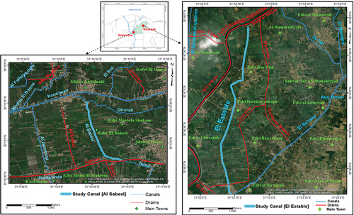
Two case studies were carefully selected to represent the prevailing conditions in the Nile Delta and to precisely forecast the potential impacts of lining the irrigation system on groundwater conditions. The first case study focuses on the El-Sabeel Canal, located in Qalyubia Governorate, situated south of the Nile Delta and is bounded by 31° 09’20’“E to 31° 11” 31.4”‘E Longitudes and 30° 18’ 26”“N to 30° 20” 04”‘ N Latitudes covering a total area of about 12.25 km2. This case study represents the semi-confined aquifer conditions prevalent in the Nile Delta (Research Institute for Groundwater RIGW, Citation1992). The second case study revolves around the El-Estable Canal, situated in Sharqia governorate, located east of the Nile Delta and is bounded by the coordinates of 31° 51’ 48”“E to 31° 54” 07.1”‘E Longitudes and 30° 45’ 41.6”“N to 30° 48” 11.7’’ N Latitudes with a total area of 18 km2. It represents the phreatic aquifer conditions present in the Nile Delta. illustrates the precise locations of these selected case studies.
Figure 1. Locations and satellite images of study areas of El Sabeel canal in Qalyubia and El Estable canal in Sharqia, Egypt.
El-Sabeel canal characteristics
El-Sabeel canal total length is about 1.7 km with an average bed width of 1 m and depth of 1 m. Its surface water levels extended from an initial elevation of 13.8 m to roughly 13.65 m at its end above mean sea level (AMSL). Its study area is located in old agricultural lands, with a topography ranges from 15 to 16 AMSL, interspersed with some urban area. Often these lands are irrigated by surface water sources from the canals network in the region with the supplement of groundwater wells that are dug specifically for irrigation purposes, as the depth of the groundwater in the area is generally less than 6 m. It is located in the Quaternary aquifer, it is hydro-geologically classified into two units; the upper one is an aquitard and the lower unit is the Pleistocene aquifer (El-Fakharany & Mansour, Citation2009) characterized by layered deposits of loose sand, gravel, and intermittent clay lenses. The Quaternary aquifer is generally underlain by a thick impervious clay layer of Pliocene age. This aquifer exhibits high productivity, transmissivity, and storage coefficient. It is considered a semi-confined aquifer due to the presence of a cap on top consisting of clay and silt with a thickness range from 1 to 16 m (). The Aquifer thickness ranges from 230 to 250 m in the study area of El-Sabeel canal. The levels of its base () ranges from −218 to −240 under mean sea level (UMSL) (Research Institute for Groundwater RIGW, Citation1989) and the average salinity of the groundwater does not exceed 500 ppm.
Figure 2. Top clay layer thickness at the study area of Al Sabeel canal.
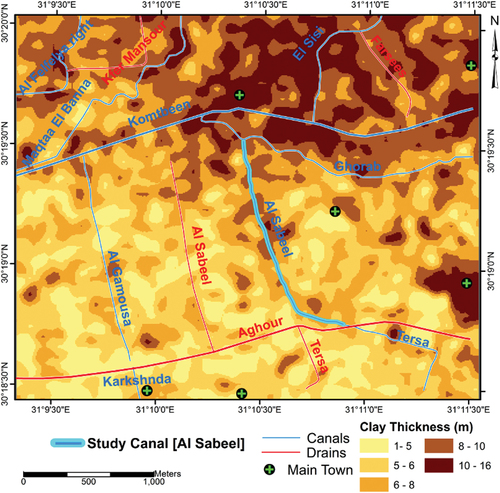
Figure 3. Base of aquifer at the study area of Al Sabeel canal (a) and El Estable canal (b).

El-Estable canal characteristics
El-Estable canal length is about 4.1 km with an average bed width of 1.75 and depth of 1.3 m. It begins from a stage elevation of 3.55 m at the outset to approximately 3.25 m AMSL toward its end. Its study area is located within the modern floodplain. The area’s topography ranges from 2 to 12 m AMSL and is mainly irrigated with surface water sources from the canal network in the area. The aquifer condition in the El-Estable canal region is unconfined, with no clay cap on the top. This aquifer primarily comprises graded sand and gravel with intermittent clay lenses. It demonstrates a considerable level of transmissivity and productivity. It has a thickness ranging from 400 to 470 m. The levels of its base () range from −400 to −490 UMSL (Research Institute for Groundwater RIGW, Citation1991). The average salinity of the shallow groundwater at the El-Estable study area ranges from 1000 to 2000 ppm at depths of about 10 to 15 m; while at deeper zones, 50 m depth, it ranges from 3000 to 4000 ppm.
The hydraulic parameters of aquifer layers in the two study areas that were initially used are presented in . The basic data were derived from previous studies (Morsy, Citation2009) and also from both Research Institute for Groundwater (RIGW) (Citation1989) and Research Institute for Groundwater (RIGW) (Citation1991) Hydrogeological maps.
Table 1. Aquifer thickness and hydraulic parameters for simulated areas.
Field work for the modeled areas
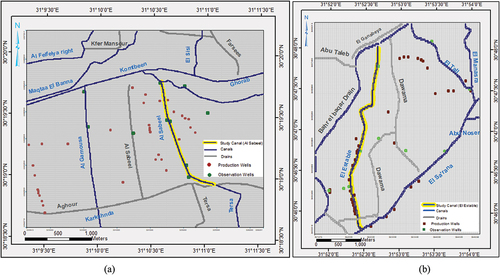
Fieldwork encompassed a comprehensive inventory of extraction points, land use, crop patterns, canals, and drains in the study area. To investigate and assess the impact of canal lining on groundwater dynamics, a total of approximately 10 observation wells were installed around each selected canal, as shown in . These wells were strategically positioned at depths ranging from 11 to 24 m below the ground surface. Groundwater level measurements within each piezometer were meticulously monitored before and after the lining intervention. Additionally, an inventory of pumping wells utilized by local farmers within each study area was performed, documenting their coordinates, type, total depth, screen specifications, and discharge depths.
Figure 4. Grid Mish, installed observation wells, and production wells at El-Sabeel(a) & El-Estable (b) study areas.
Numerical groundwater flow modeling
Numerical modeling provides a valuable approach for assessing the impact of lining distributary canals on groundwater conditions. In this study, Visual MODFLOW software version 2005 (Harbaugh, Citation2005) was employed, incorporating the packages the Rivers, Drains, Wells, and Recharge (from irrigation) Packages. The model assumes a flow process involving a single fluid, basically water, with constant parameters (density, viscosity, and temperature), in a single phase (liquid). The phase flow is assumed to be laminar and linear, and Darcy’s conditions are assumed to be applicable (Loudyi, Falconer, & Lin, Citation2014).
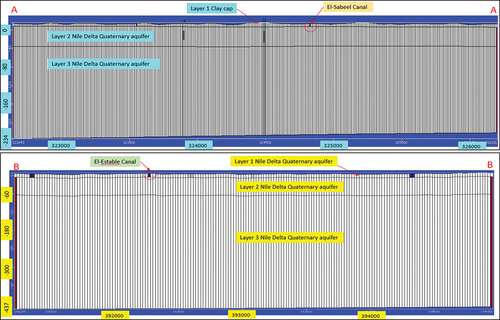
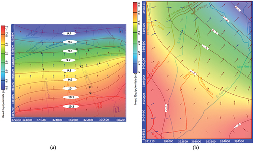
Based on field investigations, data analysis, and GIS-based contouring. For the boundary conditions, the specified groundwater heads at the El-Sabeel area ranged from 9.4 m+MSL in the north to approximately 10.3 m+MSL in the south. In the El-Estable study area, these heads varied from 2 m+MSL in the north to around 2.7 m+MSL in the south. The overall abstraction from the existing production wells are estimated to be 6670 m3/day and 6275 m3/day at El-Sabeel and El-Estable study area respectively. presents the locations of production wells. All other boundary conditions including streams, drains, and recharge rates were defined into the models. Two separate models were developed using these input parameters. For El-Sabeel Canal model area (covering 12.25 km2), a finite difference grid mesh was implemented (), comprising 400 rows and 400 columns and divided into three an upper clay layer and two layers representing the aquifer. While, the simulated area for El-Estable encompassed 18 km2 and utilized a mesh consisting of 150 rows and 190 columns (), comprising a single hydrogeological layer. But for the sake of precise modeling, it was partitioned into three layers. In addition, Bahr El Baqar drain was simulated as river package as it acts as a main drainage water carrier. Horizontal cross sections A-A in El-Sabeel & B-B in El-Estable study areas are presented in .
Figure 5. Horizontal cross sections A-A in El-Sabeel & B-B in El-Estable study areas.
The calibration process of the steady state condition utilized the collected groundwater head records from installed observation wells (10 observed values of groundwater heads in each study area) before the lining process. The results of calibration are shown in . The initial phase involved developing a steady-state model, including a one-year warm-up period, to calibrate the calculated piezometric heads with the measured values in 2021 (pre-lining intervention). The calibrated results from the heads in 2021 were visualized through color-shaded contour maps, as illustrated in for the two study areas. The calibration outcomes for the El-Sabeel and El-Estable study areas yielded a root mean squared error of 0.152 and 0.081, respectively, with corresponding correlation coefficients of 0.958 and 0.932. The calibrated values of hydraulic conductivity for the aquifer layers ranged from 30 to 70 m/d in El-Sabeel study area; while in El-Estable study area, it ranged from 40 to 60 m/d. The calibrated specific storage for the two study areas ranged from 10−5 to 10−4 m−1.
Figure 6. Observed versus calculated groundwater heads (m) for model calibration in 2021 at El-Sabeel(a) & El-Estable (b) study areas.
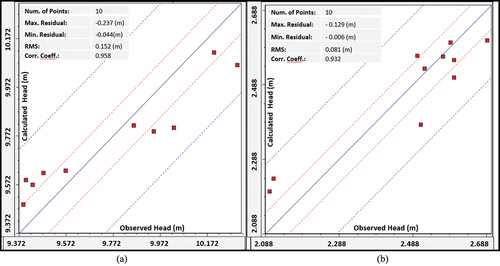
Figure 7. Calibrated groundwater head contour map and velocity distribution in 2021 for the study areas of El-Sabeel (a) and El-Estable (b).
Assessing the impact of lining on groundwater heads
The lining impact on the seepage from the canals is reflected by changing the conductance values in the tested scenarios. In the calibrated model, the conductance of canals was represented by the values of natural conditions at each study area. Thus, as the lining was applied, the conductance values were reduced proportionally to the efficiency of the concrete lining at each stage. As previously mentioned, it has been observed that cracks and holes are accountable for the increased seepage loss. The newly constructed lining combination significantly reduces seepage by approximately 90% compared to the absence of lining. After three years of service, seepage can be further reduced by 70%, and this amount decreases to 10% after an additional three years of service, due to poor maintenance or any misfunction in the lining.
To evaluate the impacts of the lining scenarios, a transient state period of 10 years is considered (one-year warm-up period). This period encompasses two distinct scenarios: scenario 1 examines the effect of lining over the next 9 years without periodic maintenance, and scenario 2 assesses the effect of lining over the next 9 years with periodic maintenance.
Results
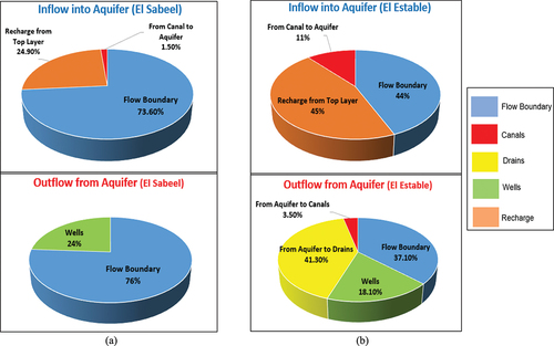
By analyzing the water balance data of El-Sabeel study area during the steady state condition prior to the lining intervention, it is revealed that the main component of inflow is attributed to the boundary flow, which accounts for 73.6% of the total inflow as shown in . In contrast, in the El-Estable area, the net recharge from the top layer is the main contributor, constituting approximately 45% of the total inflow. Since both regions primarily serve as agricultural areas, the recharge from the top layer in El-Sabeel is also significant, estimated at around 24.9%. The infiltration from the canals to the aquifer is relatively small in the El-Sabeel area, constituting only 1.5% of the total inflow, while in El-Estable area, it reaches approximately 11%. The corresponding quantities of the infiltration from all canals to the aquifer are approximately 16,440 and 85,040 m3/year/Km in the study areas of El-Sabeel and El-Estable, respectively.
Figure 8. Water balance analysis for the calibration prior to lining El-Sabeel (a) and El-Estable (b) study areas.
The records of observed groundwater levels from the installed observation wells before and after lining indicated a decrease of approximately 0.08 m around the El-Sabeel canal and 0.16 m around the El-Estable canal.
Zone Budget was calculated to determine the exact amount of water leakage from the two studied canals in each study area. The results show that the amount of water leakage before lining from El-Sabeel and El-Estable canals are about 4 728 and 275 085 m3/year/km respectively.
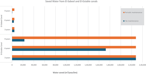
Following an initial warm-up period of one year to ensure model stability, Scenario 1 examines the long-term consequences of neglecting periodic maintenance for canal lining over the course of 9 years. The findings indicate that the anticipated water conservation through lining after 3 years would be 4256 m3/year/km for the El-Sabeel canal and 227,787 m3/year/km for the El-Estable canal. However, after 6 years since the canal lining was implemented, the water savings will decrease to about 3310 m3/year/km for the El-Sabeel canal and 172,338 m3/year/km for the El-Estable canal. This decline can be attributed to a reduction in lining efficiency to 70%. Finally, by the 9th year after canal lining, it is expected that the water conservation is limited to about 473 m3/year/km for the El-Sabeel canal and 22,679 m3/year/km for the El-Estable canal.
Scenario 2 investigates the long-term implications of consistently maintaining canal lining over a period of 9 years. According to the findings, the water conservation achieved is anticipated to remain stable throughout the entire 9-year period of regularly maintaining canal lining. After 3, 6, and 9 years of canal lining, it is expected that the achieved water saving will be approximately 4256 m3/year/km for the El-Sabeel canal and around 227,787 m3/year/km for the El-Estable canal.
These results assume that lining efficiency will be maintained at an optimal level due to adequate maintenance practices.
shows the amount of saved water for the two tested scenarios applied to the lining for the study areas. The difference between saved water after 9 years for no maintenance scenario (scenario 1) and periodic maintenance scenario (scenario 2) would expected to be around 3783 m3/year/km and 205,110 m3/year/km for El-Sabeel canal and El-Estable canal, respectively.
Figure 9. The amount of saved water calculated for the tested scenarios within the next 9 years from El-Sabeel and El-Estable canals.
Discussions
The objective of the research study is assessing the impacts of the lining of distributary canals on groundwater status through numerical modeling. Two specific case studies were chosen to represent the prevailing conditions in the Nile Delta. The first case study focuses on El-Sabeel Canal, situated in Qalyubia Governorate, south of the Nile Delta, where the aquifer is overlain by a silty clay layer which acts as an aquitard and allows for local confinement. The second case study examines El-Estable Canal, located in Sharqia governorate, east of the Nile Delta, and represents the phreatic aquifer conditions of the Nile Delta. To conduct the study, field investigations were carried out, and 10 observation wells were drilled around each study canal. Additionally, surveying work was performed to determine local water levels, thickness of the top clay layer, locations of extraction wells, and land-use analysis. The finite difference MODFLOW 2005 package was employed to simulate groundwater flow and calibrate the hydrogeological conditions specific to each case study. The simulation also incorporated the interaction between surface water and groundwater to assess the impact of canal lining on groundwater conditions. Water balance analysis was conducted for the calibrated models, and a detailed zone budget was calculated for each of the case studies. Two scenarios were evaluated using the calibrated models.
Scenario 1 represents the conditions of poor or neglected periodical maintenance, leading to the deterioration of the lining material over time and the occurrence of cracks. Hence, gradual reduction in the lining impact, subsequently diminishing its overall efficiency. This decline ultimately mirrors the initial state before the lining was implemented, and a regression to the original case before the lining is observed after a span of 9 years.
In contrast, Scenario 2 considers the implementation of regular maintenance practices. In the case of El-Sabeel Canal, the lining effects yield significant results, preventing the loss of 7234.56 m3/yr or 4255.62 m3/yr/km of water that would otherwise seep into the shallow groundwater. For El-Estable Canal, the impact is even more substantial as it is a phreatic aquifer, resulting in the conservation of approximately 1 million m3/yr, or 0.2 million m3/yr/km when a systematic maintenance routine is diligently followed.
From the two scenarios, it is obvious that failure to uphold regular maintenance of the lined canal would decrease the lining efficiency up to 90% as a long-term impact. This revert is not only presents a setback in functionality but also results in financial losses due to the expenses involved in implementing the lining.
From another perspective, these volumes of conserved water historically replenished the shallow groundwater aquifer before the installation of the lining. Reduced seepage could significantly affect downstream water availability. Downstream users rely on groundwater during dry periods or when surface water supplies are insufficient. Reduced seepage would decrease groundwater potentiality. Additionally, potential water quality degradation, especially salinity in areas where groundwater abstraction exceeds recharge, may occur. Given that canal lining can have far-reaching consequences, effective and integrated water resource management strategies are essential to mitigate these impacts and ensure sustainable water use for present and future generations.
Conclusions
In conclusion, a thorough analysis of the effects of lining canals on shallow groundwater has provided valuable insights. This analysis involved studying seepage rates before and after lining using numerical simulations. Seepage rates are highly influenced by the type of soil underlying the canal, highlighting the importance of soil composition in determining how canal lining interacts with groundwater. In sandy soil conditions, well-maintained canal lining can significantly reduce seepage, potentially saving up to 0.2 million cubic meters per year per kilometer of canal. However, in areas with clayey soil, the importance of canal lining in preventing seepage to shallow groundwater is limited.
Regular maintenance and ensuring that the concrete lining is free of cracks are crucial for maintaining the long-term efficiency and sustainability of canal lining systems. Failure to uphold regular maintenance of the lined canal may result in potential leakages that could decrease the lining efficiency up to 90% after 9 years. While canal lining serves as an essential tool for optimizing water distribution and facilitating efficient water transport to canal tails, it can also have far-reaching consequences such as reducing seepage that might decrease groundwater potentiality. Therefore, effective and integrated water resource management strategies are essential to mitigate these impacts and ensure sustainable water use for present and future generations.
Recommendations
Based on the research methodologies and findings, the study recommends the following:
Prioritizing regular maintenance practices for canal linings to sustain lining efficiency over time and to fulfill cost-effectiveness.
Exploring alternative canal lining materials and methods, as well as, exploring nature-based lining materials. Since, lining is notably more effective in areas with sandy soils.
Investigating the effects of different maintenance strategies on the effectiveness of canal linings, considering various soil types, hydrogeological circumstances, and their cost-effectiveness.
Exploring innovative non-mechanical environmental canal maintenance methods.
Adapting integrated water resource management to mitigate potential impacts of canal lining.
Disclosure statement
No potential conflict of interest was reported by the author(s).
References
- Abd‐Elaty, I., Pugliese, L., Bali, K. M., Grismer, M. E., & Eltarabily, M. G. (2022). Modelling the impact of lining and covering irrigation canals on underlying groundwater stores in the Nile Delta, Egypt. Hydrological Processes, 36(1), e14466. doi:10.1002/hyp.14466
- Abu-Zeid, T. S. (2021). Compatibility between Canals Lining Methods and Sites Conditions Case Study: Al-Khofoog Canal, El-Minia. MEJ- Mansoura Engineering Journal, 46(3), 1–9. doi:10.21608/BFEMU.2021.184346
- Aldea, C. M., Shah, S. P., & Karr, A. (1999). Permeability of cracked concrete. Materials and Structures/Materiaux Et Constructions, 32(5), 370–376. doi:10.1007/BF02479629
- Ali, H. M. (1990). Seepage from imperfectly lined canals ( Master thesis). Faculty of Engineering Cairo University.
- Barkhordari, S., Shahadany, S. H., Taghvaeian, S., Firoozfar, A. R., & Maestre, J. M. (2020). Reducing losses in earthen agricultural water conveyance and distribution systems by employing automatic control systems. Computers and Electronics in Agriculture, 168, 105122. doi:10.1016/J.COMPAG.2019.105122
- El-Fakharany, M. A., & Mansour, N. M. (2009). Assessment of water resources quality at the southeastern part of the Nile Delta, Egypt. The International Conference on Water Conservation in Arid Regions (pp. 12–14). https://www.researchgate.net/profile/M-A-El-
- Elkamhawy, E., Zelenakova, M., Straface, S., Vranayová, Z., Negm, A. M., Scozzari, A., & Abd-Elaty, I. (2022). Seepage loss from unlined, lined, and cracked-lined canals: A case study of Ismailia canal reach from 28.00-49.00 Km, Egypt. EGU General Assembly Conference Abstracts (pp. EGU22–13134). doi:10.5194/EGUSPHERE-EGU22-13134
- El-Nashar, W. Y., & Elyamany, A. H. (2018). Value engineering for canal tail irrigation water problem. Ain Shams Engineering Journal, 9(4), 1989–1997. doi:10.1016/j.asej.2017.02.004
- El-Rawy, M., Abdalla, F., & El Alfy, M. (2019). Water resources in Egypt. InThe geology of Egypt (pp. 687–711). Cham: Springer International Publishing. doi:10.1007/978-3-030-15265-9_18
- Eltarabily, M. G., Elshaarawy, M. K., Elkiki, M., & Selim, T. (2023). Modeling surface water and groundwater interactions for seepage losses estimation from unlined and lined canals. Water Science, 37(1), 315–328. doi:10.1080/23570008.2023.2248734
- Food and Agriculture Organization (FAO). (1986). The organization and maintenance of irrigation schemes. Chapter 6 (Maintenance service). https://www.fao.org/3/X5647E/x5647e0a.htm
- Gad, M., Abdelhaleem, H. M., & Oas, W. (2023). Forecasting the seepage loss for lined and un-lined canals using artificial neural network and gene expression programming. Geomatics, Natural Hazards and Risk, 14(1), 2221775. doi:10.1080/19475705.2023.2221775
- Ghazaw, Y. M. (2011). Design and analysis of a canal section for minimum water loss. Alexandria Engineering Journal, 50(4), 337–344. doi:10.1016/J.AEJ.2011.12.002
- Han, X., Wang, X., Zhu, Y., Huang, J., Yang, L., Chang, Z., & Fu, F. (2020). An experimental study on concrete and geomembrane lining effects on canal seepage in arid agricultural areas. Water, 12(9), 2343. doi:10.3390/W12092343
- Harbaugh, A. W. (2005). MODFLOW-2005, the US geological survey modular ground-water model: The ground-water flow process (Vol. VI). Reston, VA, USA: US Department of the Interior, US Geological Survey. https://www.usgs.gov
- Hefny, K., & Shata, A. (2004). Underground water in Egypt. Ministry of Water Supplies and Irrigation, Cairo, Egypt, 295, 138–146. in Arabic.
- Jaboyedoff, M., Ben Hammouda, M., Derron, M. H., Guérin, A., Hantz, D., & Noel, F. (2021). The rockfall failure hazard assessment: Summary and new advances. Understanding and Reducing Landslide Disaster Risk: Volume 1 Sendai Landslide Partnerships and Kyoto Landslide Commitment 5th, 55–83. doi:10.1007/978-3-030-60196-6_3
- Jadhav, P. B., Thokal, R. T., Mane, M., Bhange, H. N., & Kale, S. R. (2014). Conveyance efficiency improvement through canal lining and yield increment by adopting drip irrigation in command area. International Journal of Innovative Research in Science, Engineering & Technology, 3(4), 120–129.
- Kilic, M., & Tuylu, G. I. (2011). Determination of water conveyance loss in the ahmetli regulator irrigation system in the lower Gediz Basin Turkey. Irrigation and Drainage, 60(5), 579–589. doi:10.1002/IRD.602
- Loudyi, D., Falconer, R., & Lin, B. (2014). Scientific report.
- Merkley, G. P. (2007). Irrigation conveyance and control: Flow measurement and structure design. Lecture Notes, Biological and Irrigation Engineering Department, Utah State University. http://slidepdf.com/reader/full/irrigation-conveyance-control-flow-measurement-structure-design
- Ministry of Public Works and Water (MPWWR). (1988). Project No EGY/85/012 Final Report.
- Morsy, W. S. (2009). Environmental management of groundwater resources in the Nile delta region ( Doctoral dissertation). Faculty of Engineering, Cairo University. Retrieved from http://www.secheresse.info/spip.php?article77753
- Mpendulo, N. (2009). Canals, chapter 5 Maintenance and repair, 30-34. https://www.academia.edu/42866607/Canals_Chapter_5_Maintenance_and_repair_works
- Research Institute for Groundwater (RIGW). (1989). Hydrogeological map of Cairo, Scale 1:100 000.
- Research Institute for Groundwater (RIGW). (1991). Hydrogeological map of Zaqaziq, Scale 1:100000.
- Research Institute for Groundwater (RIGW). (1992). Hydrogeological map of Nile Delta, Scale 1: 500000.
- Shaw, G. D., Conklin, M. H., Nimz, G. J., & Liu, F. (2014). Groundwater and surface water flow to the merced river, Yosemite valley, California: 36Cl and Cl− evidence. Water Resources Research, 50(3), 1943–1959. doi:10.1002/2013WR014222
- Snell, M. (2001). Lining old irrigation canals: Thoughts and trials1. Irrigation and Drainage, 50(2), 139–157. doi:10.1002/IRD.13
- State Information Service (SIS). (2022). Rehabilitation and lining of canals and waterways in different governorates. https://www.sis.gov.eg/Story/172877/Rehabilitationandliningofcanalsandwaterwaysindifferentgovernorates-SIS
- Swamee, P. K., & Chahar, B. R. (2015). Design of canals. Chapter 2 objective functions, 15. doi:10.1007/978-81-322-2322-1
- Wael, M., Riad, P., Ali Hassan, N., & Ragab Nofal, E. (2024). Assessment of modern irrigation versus flood irrigation on groundwater potentiality in old clayey lands. Ain Shams Engineering Journal, 15(4), 102776. doi:10.1016/j.asej.2024.102776
- Wang, K., Jansen, D. C., Shah, S. P., & Karr, A. F. (1997). Permeability study of cracked concrete. Cement and Concrete Research, 27(3), 381–393. doi:10.1016/S0008-8846(97)00031-8
- Yi, S. T., Hyun, T. Y., & Kim, J. K. (2011). The effects of hydraulic pressure and crack width on water permeability of penetration crack-induced concrete. Construction and Building Materials, 25(5), 2576–2583. doi:10.1016/J.CONBUILDMAT.2010.11.107
- Zhang, Q., Chai, J., Xu, Z., & Qin, Y. (2017). Investigation of irrigation canal seepage losses through use of four different methods in hetao irrigation District, China. Journal of Hydrologic Engineering, 22(3). doi:10.1061/(ASCE)HE.1943-5584.0001470