
ABSTRACT
The paper investigates the sources of water leakage in Mokattam, Cairo, Egypt. It is considered a high-risk zone for landslides due to the presence of problematic soil, topography, and water conditions. The objective is to mitigate the negative impact of underground water on landslide disasters. The proposed methodology involves field visits, satellite image processing, Ground Penetration Radar scanning, chemical and isotope analysis of water, and evaluating the water and sanitary networks within the study area. The findings revealed that the underground water is formed because of the continuous leakage from the existing networks. Moreover, there was no evidence of any aquifers, particularly at Ain Mosa floating point. Thus, the accumulated water in the unsaturated zone is not sustainable for long-term development for its limited potential and poor quality. Consequently, immediate action plan is required to assess and upgrade the water and sanitary networks through the implementation of innovative technologies for such hydrogeologic conditions
Introduction
Landslides cause disastrous societal impacts on a worldwide scale threatening the landscape, and infrastructure and consequently causing the loss of people’s lives (Collins et al., Citation2021; Guzzetti, Citation2021). This phenomenon costs millions of dollars for the rehabilitation process of damaged properties (Guzzetti, Citation2021; Pradhan & Lee, Citation2010). Recently, many countries established authorities to mitigate the negative effects of landslides (Pradhan & Lee, Citation2010; Yue, Citation2013). The main triggering factors that cause landslides include groundwater circulations, thermal cycles, earthquakes, rainfall, etc. (Jaboyedoff et al., Citation2021; Pradhan & Lee, Citation2010). Leakage from networks is a main source for water table rise in residential areas. The estimated annual financial losses from this leakage are 14.6 billion worldwide according to a World Bank report (Haider et al., Citation2019; Rashid et al., Citation2014). The percentage of water leakage generally varies from 8 to 40% (Haider et al., Citation2022).
Recently, several landslides were recorded in Egypt, especially in the highland residential areas, such as the collapses that occurred in the Zbaleen mansion area, the southern scarp of the high plateau of Mokattam mountain, rock masses on the northern road of Mokattam mountain, and the occurrence of several collapses at Manshiat Nasser (Effat & Hegazy, Citation2014; Giang et al., Citation2015; Mohamed et al., Citation2012). Mokattam city is one of the most crowded cities in Egypt. It is located to the east of Cairo on El-Mokattam mountain with an average elevation of 200 m (AMSL) (El-Hadidy, Citation2021; Hereher, Citation2017; Khair, Citation2015). Urbanization activity started in the middle of the 20th century (Khair, Citation2015) with variable types of buildings and recently it has experienced rapid population growth. The variation in topographic levels, sharp cliffs, and stratigraphy that contains various types of problematic soil causes many collapsing problems in Mokattam city; which makes this area one of the significant points of interest for researchers. Most of these researchers studied the negative effect of anthropogenic activity in the area. In one research, the link between urbanization and land temperature in the Mokattam plateau as well as the leakage from the water and sanitary networks associated with geological hazards were also studied (El-Hadidy, Citation2021). Another research focused on the impact of earthquake activity in the study area; indicating that the area is threatened by earthquakes and resulting collapses (Araffa et al., Citation2021). It recommended considering the locations of faults and their negative effect on the urban zone. It also emphasized the resulting hazard from the interaction between leakage water and swelling soil intercalation between limestone layers. Several buildings in the area have been damaged by differential settlement due to leakage from the networks (Elgohary et al., Citation2022; Mohamed et al., Citation2008).
Previous research studies proposed solutions to overcome landslide problems such as face trimming, steel fiber reinforced concrete, and guard steel cables … etc. (El-Nahhas et al., Citation2007; Giang et al., Citation2015). The consensus among previous studies is that the most significant threats in the area stem from water, problematic soil types, and topography. Most researchers assert that water serves as the primary triggering factor for landslides.
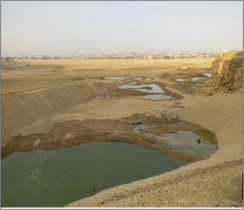
There are a lot of disagreements in the literature studies about water sources in the study area as some researchers consider it leakage from networks (Elgohary et al., Citation2022), and others consider it a groundwater spring (A. N. Hassan et al., Citation2013; N. A. A. Hassan et al., Citation2012; Sultan et al., Citation2008). Ain Mousa is a flowing point within the study area. Some researchers consider it a natural spring, while others consider it a leakage point from the water and sanitary networks. Due to the fractured nature of the limestone in Mokattam, water moves fast and randomly in the direction of the point of lower energy. A review of the historical images indicated that the flowing water from Ain Mousa, as well as in several locations in the area, appears in a certain location, then moves with gravity, according to the ground levels, and finally sinks and disappears at a low point. This water formed some scattered lakes along the paved roads where the base filling material cuts off the flow lines at the low disappearing point as shown in (). While the phenomena are repeated in other locations in the study area, the possible collapse of landscape and construction is anticipated.
Figure 1. Formed lakes in the study area.
Addressing the origins of this flowing subsurface water becomes imperative, particularly in scenarios where network leakage is probable, as effective control would significantly diminish the potential landslide hazards.
Numerous investment projects in the study area are threatened by the presence of this flowing water. Resolving these discrepancies would aid decision-makers in addressing the issue and preventing landslide in the area.
The objective of the research is to explore the sources of groundwater in the Mokattam area & address conflicts in earlier research about its origin. As defining water source would help evaluating the expected negative impact of this water on landslide disasters. The objective is achieved by adopting an integrated approach that includes several techniques such as satellite image processing, field visits, chemical and isotopic analysis of water samples, Ground Penetration Radar (GPR) scanning, and finally evaluation of the water and sanitary network in the area.
Materials and methods
General approach
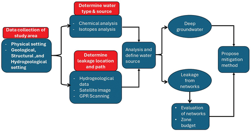
All previous research has agreed that this water, whatever its source, is the main triggering factor of landslides however, they did not confirm the sources of this water. The main target of the current research is to investigate the source of the detected water in the study area and recommend an optimal solution to mitigate its negative impact on landslides. The research scheme is presented in (), where all collected data for the study area are stated (geology, topography, hydrology, satellite images, etc.).
Figure 2. Research methodology for exploring the water origin.
Physical and hydrogeological settings
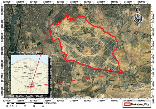
Mokattam city is located in the southeast of the Greater Cairo Governorate and consists of a series of plateaus that are part of El-Maaza Plateau’s northwestern extensions, which separate the Eastern Desert from Cairo. The city is bounded to the north by Gebel Ahmar, to the south by the Maadi – Qattamia Road and El Maadi depression, to the east by the Ring Road and New Cairo City, and to the west by the urbanized area of Greater Cairo. The study area extends between 31°16’00.00” E and 31°21’00.00” E Longitude and 29°59’40.00” N and 30°02’00.00“N Latitude (). The climate of Mokattam Mountain can generally be classified as dry with scarce rainfall. The temperature in the area varies between 8 and 37°C. The average annual rainfall is 22 mm in the highlands. Evaporation over the mountain is generally high, with a relative humidity of about 44% (El-Hadidy, Citation2021).
Figure 3. Location of the study area in Egypt.
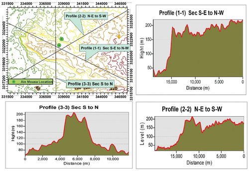
Human intervention has significantly altered the landscape of Mokattam city, particularly through increased land use. As the population has expanded, the urban footprint, including residential, commercial, and industrial areas, has extended into previously undeveloped land. This expansion necessitates the establishment of infrastructure such as water networks to accommodate the needs of the growing population. The geomorphology of the area, characterized by its higher elevation compared to surrounding urban areas, has been subject to modification due to human activities. The topography of Mokattam city is higher than all surrounding urban areas in all directions except the east (Moustafa et al., Citation1991). The plateau is about 250 m (AMSL) and is surrounded by an urban area with an elevation of about 24 m (AMSL). Digital Elevation Models from satellite data were processed to contour the topographic levels. () presents three elevated sections for the area. Section (1–1), southeast to northwest, is stable at the sharp Cliff of the plateau, where the topography drops dramatically from an average level of 180 m (AMSL) to an average of 25 m (AMSL) in the vicinity of the residential area. Also, the sharp Cliff is located at the contact line between the upper and lower plateau as shown in (section 2–2). The contoured map indicates the collected leakage points which are located mostly beside the sharp cliffs as in the case of Ain Mousa.
Figure 4. Topography of Mokattam Plateau. Section (1–1), southeast to northwest profile, section (2–2), northeast to southwest profile, section (3–3), south to north profile.
Geologically, the Mokattam plateau consists of a thick succession of sedimentary carbonates with thinner beds of clay, shale, and marl. It is subdivided into two major formations: the Maadi Formation, from upper Eocene rock, which is composed of a series of brownish units of fissured limestone, marl, and shale; and the Mokattam Formation, from middle Eocene rock, which consists of upper building stone, Gizehensis limestone, and lower building stone (Araffa et al., Citation2021).
Structurally, the El-Mokattam area is considered part of the Cairo-Suez structural region. This region includes the mountain series located north and south of the Cairo-Suez Road and is characterized by numerous normal faults that have main directions of WNW-ESE and NW-SE. The Mokattam rocks are subjected to large numbers of normal faults, joints, and fractures, in addition to two monoclines in the eastern and northeastern parts. The faults have dip angles ranging between 60° and 71° (Araffa et al., Citation2021).
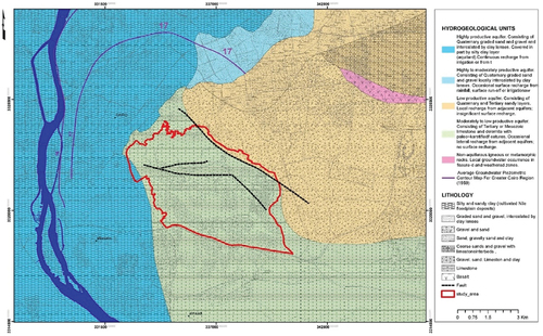
Hydrogeologically, all previous studies concluded that the appearance of surface water in Mokattam City is from two sources; leakage from water and sanitary networks, and groundwater springs. There is no doubt that the leakage from pipeline networks has a significant contribution to this water but with an unreliable percentage. The hydrogeological map of the study area shown in () indicates that the study area is located on a limestone aquifer which is an extensive or local and generally moderately productive aquifer. In addition, a small portion of the study area is located on another aquifer that consists of sand and gravel with an extensive or local, low-productive aquifer.
Figure 5. hydrogeological map for the study area (depicted from RIGW, 1998).
Methodology
Satellite images were used to locate the leakage locations and then, GPR scanning was employed to discern the water paths. Chemical analysis was conducted to determine the quality and type of water, while isotope analysis was performed to identify the source of the water. In addition, the sanitary and water networks were evaluated to estimate the water losses from the system. Finally, all results were analyzed to produce clear maps for discussing the research goals and finding a suitable solution.
Satellite image processing
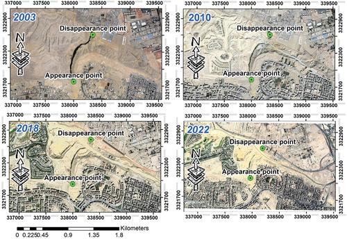
At the beginning of the 21st century, numerous projects were developed in Mokattam and the nearby areas. These projects significantly reshaped the landscape of the plateau. Since the satellite-capturing process for the earth started in the 1970s, all development projects of various types were recorded with variable resolution according to the time and satellite upgrading technologies. The satellite images show that urbanization increased by about 72% over the last 20 years (Shalapy, Citation2022). The images clearly show leakage locations over the whole area and indicate undeniable relationship between leakage points and urbanization (). They also show the changing of the leakage locations (). The figure shows the behavior of water in Ain Mosa over time relative to project construction in the surrounding areas. Ain Mosa is a point of an unknown source of flowing water in Mokattam city. The satellite image shows that the water appears in a high location, moves down the valley with the land topography, and finally, disappears at a low point ( in 2003). Two new roads were constructed and crosscut the flow path of water. The first one was established in 2010 and overcame the flow path with a culvert; then the second one was established in 2018 and crosscut the disappearing point forming lakes that threaten road safety. The problem was then solved by constructing a canal beside the road to allow water infiltration into the ground under the road ( in 2022)
Figure 6. Leakage locations over the whole area.
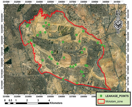
Figure 7. Effect of reshaping the landscape of the plateau on leakage location.
Chemical analysis
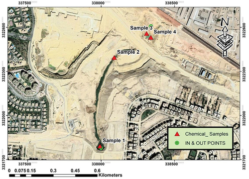
Four groundwater/surface water quality samples were collected from the study area. The samples were analyzed for various parameters including physicochemical properties, cations, anions, trace metals, and microbiological parameters (). The laboratory results indicated that the pH values vary between 7.62 to 7.81 and TDS values vary between 6318 and 8442 mg/l. The concentration values of the major cations exhibited high values such as sodium (1500–2000 ppm), calcium (367–542 ppm), and magnesium (137–173 ppm). Similarly, the concentration values of the major anions were as follows: chloride (2222 to 3000 ppm), sulfate (1511 to 1740 ppm), and bicarbonate (189 to 255 ppm).
Figure 8. Locations of collected samples for chemical analysis.
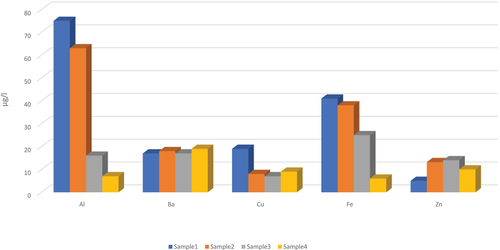
A Piper diagram () was used to classify the water type, which was found to be Sodium-Potassium type for cations and Chloride type for anions with Sodium-Chloride type salts (Piper, Citation1994). The results of the trace metal analysis are shown in () where the concentration values for aluminum (7 to 75 µg/l), barium (17 to 19 µg/l), copper (7 to 19 µg/l), iron (6 to 41 µg/l), and zinc (5 to 14 µg/l) were recorded. The concentration values for the other trace metals were less than 9 µg/l. The laboratory analysis for nitrate, nitrite, phosphate, total and fecal coliform was also performed. The results of the chemical analysis revealed that nitrate concentrations ranged from 102 to 180 mg/l, and nitrite and phosphate concentrations were below 0.2 mg/l. Total and fecal coliforms ranged from 140–174 CFU/100 ml and 67–109 CFU/100 ml respectively. The detection of nitrate, total and fecal coliform in the water samples confirms that the source of the sampled water is network leakage.
Figure 9. Water types according to piper trilinear diagrams (piper, Citation1944).
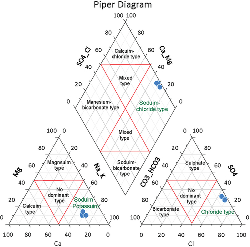
Figure 10. Concentrations of heavy metals.
Water isotopes analysis
An isotope of an element is defined as two or more specific atomic species of the same chemical element having different atomic masses (Siegel, Citation1983). The isotope composition of the water molecule in groundwater can contain valuable information on the hydrologic processes that have been taking place. Isotopes of both hydrogen and oxygen in water are fractionated by evaporation and precipitation in the hydrologic cycle and by chemical reactions with rocks due to slightly different vapor pressures and freezing points. When water evaporates, the water vapor is depleted with regards to the heavier isotopes 2H and 18O; the solution that remains behind is enriched Rain, therefore, has a relatively light composition and becomes lighter with each rainfall. The hydrogen isotopic variation is expressed as enrichment or depletion of the less abundant isotope 2H with respect to the more abundant 1H. Oxygen isotopic variation is expressed similarly: 18O to16O.
The results obtained are expressed in a δ notation that represents the isotopic deviation of the water sample with respect to the international reference value (SMOW for 18O & D in water samples) and are calculated as parts per thousand (‰) as: δ (‰) = (Rsample/Rreference-1) *103 (where R is the ratio of the less abundant isotope against its more abundant counterpart (2H/1H, 18O/16O).
The isotopic data for reference samples are reported using the conventional delta (δ) notation, in units of permil (‰) deviation relative to Vienna Standard Mean Ocean Water (V-SMOW; Coplen et al., Citation1996) as follows:
Modern precipitation (δH: −10.0 ± 15.7‰; δ18O: −2.09 ± 2.3‰)
Nubian groundwater composition (δH: −84.2 to − 80.4‰; δ18O: −10.6 to − 10.1‰)
Surface Water (e.g. Lake Nasser) (δH: 7.1‰; δ18O: 0.77‰)
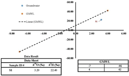
The conventional relationship of delta 18O and delta D with respect to the Global Meteoric Water Line is depicted as indicated in (), where the Ain Mousa values are recorded as δH = 22.4 ‰ and δ18O = 3.2‰). This sample shows evidence of surface water or precipitation. In the case of the study area, this is coming from drinking and sanitary networks as the area does not contain any surface water bodies nor is the precipitation significant. Moreover, it is far away from the groundwater reference values. Hence, the flowing water is not groundwater discharge.
Figure 11. The sampled data on the conventional relationship of delta 18O and delta D with respect to the global meteoric water line.
Radar investigations
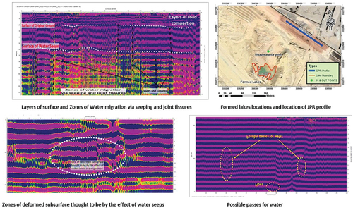
The ground penetration radar (GPR) tool was used to figure out the water flow behavior in the study area. Three GPR exploration profiles were scanned using radar (SIR) model SIR-4000 with a 100-MHz monostatic shielded antenna. The profiles were scanned on the new road that crosscut the flow path of water during the construction process (). The profile lengths ranged between 50 to 150 meters with an estimated penetration depth of up to 16 meters. The data was processed by removing any noise such as vehicles, metals, pipelines, cell phones, electrical cables, and natural electrical and magnetic source, then; enhancing the desired reflections; calibrating the horizontal distances and depths, and finally transforming radar data into usable images. The output figures clearly show the road base, natural ground levels, the fractured formation, and water distribution ().
Figure 12. GPR profile location with length of 150 meters to north of formed lakes&output image after data processing.
Network investigation
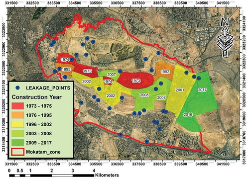
Determination of the relationship between leakage locations and urbanization zones drove the elevation of the efficiency of the drinking and sanitary networks in the study area. The evaluation was conducted by investigating the network’s ages and materials; and also, by calculating the network losses over the area. The Holding Company for Water & Wastewater (HCWW) database indicates that some of the networks in the study area were constructed in 1973 and have not been replaced until now. In addition, most of these networks were pottery pipes. The collected data was then used to produce a construction age map () which indicates that Ain Mousa is close to the earliest constructed sewage network in Mokattam City. Also, historical data revealed that before constructing the sewage uplifting station, sewage water was disposed of from these networks into wide fractured area beside Ain Mousa. Moreover, the network’s losses in parts of the study area were accurately calculated from the (HCWW) database. There is a pumping station located to the east of the study area that collects sewage water from four urban areas (Uptown Cairo, Upper Plateau, Zelzal Buildings, and Asmarat Area). The total pumped volume through the station is 80,000 m3/day according to (HCWW) data. Despite this, the total supplied volume of drinking water networks to the same areas is 170,240 m3/day. Thus, the calculated losses in the area are about 90,000 m3/day which is equivalent to about 55% of the total water supply to the area.
Figure 13. Networks construction ages in Mokattam city.
Results and discussion
Through the research methodology and to fulfill the objective of the research, a set of interrelated activities were conducted. The two probable sources of water leakage in the study area are 1) leakage from networks and 2) naturally flowing spring from deep-seated aquifers.
The hydrogeological data for the area proves that there is no aquifer in the area that might spring water up to about 180 m AMSL. This result agrees with the satellite data which point out that water locations are distributed all over the area and move with developing projects and landscape reshaping. In addition, it revealed the link between leakage spots and the urban area, especially in the case of Ain Mosa flowing water.
Before the construction of the networks in the 1990s, the water was disposed of in a wide fractured area that is close to and higher than Ain Mosa by about 25 m in level.
The results of the chemical analysis of the water samples manifested that the water in the study area is predominantly Sodium-Potassium type, with Chloride type anions and Sodium-Chloride type salts. This water type is commonly found in areas where rock weathering contributes to a high concentration of sodium, and potassium ions. Trace metal analysis revealed relatively low levels of aluminum, barium, copper, iron, and zinc, with other trace metals below the detection limit. However, the concentration of nitrate was found in the samples, ranging from 102 to 180 mg/l. Nitrates in water can result from various sources such as agricultural activities, sewage discharge, and natural processes. The presence of fecal and total coliform bacteria in the water samples indicates potential contamination from leakage from the sanitary network in the area. In conclusion, the water in the study area appears to be impacted by both natural and human-related factors, including rock weathering and human activities such as sewage disposal.
The isotopic data for the Ain Mousa values show evidence of surface water or precipitation. In the case of the study area, this is coming from drinking and sanitary networks as the area does not contain any surface water bodies nor is the precipitation significant. Moreover, it is far away from the groundwater reference values. Hence, the flowing water is not groundwater discharge.
Ground Penetration Radar (GPR) data were analyzed, and longitudinal profiles were developed. The results indicated that the upper layer is about a one-meter compacted layer, which is the road base layer that was constructed over the area followed by a layer of cracked limestone till the end of the section, with a depth of approximately 16 meters. It is also noted from the sections that water has been detected at a depth of approximately 5 meters. Radar sections showed a remarkable water presence in the limestone layer. This could be due to water infiltration through the cracks that were still open before the road construction. This water keeps moving horizontally and vertically to the northern lower areas(Al-Sittawy & Nofal, Citation2022). The resulting GPR sections reveal the formation of a water lakes behind the constructed road. As the road construction began, the cracks were filled with road base materials, which forced the movement of water downward, and over time, water accumulated south of the road and formed a several surface ponds that posed a threat to the structural integrity of the road as well as to strategic buildings in the north.
Network evaluation indicated that most of the serving networks in the area are deteriorated as they were constructed in the 1990s and were not rehabilitated or replaced until now. In addition, the calculation of the water budget of the study area confirmed that the leakage of these networks reaches 90,000 m3 per day. This huge amount of water is moving downward and laterally through the fractured limestones until reaching local depressions.
Based on the previously discussed analysis, it is evident that the predominant source of water in the Mokattam study area likely stems from leakage water, possibly originating from the sanitary and water networks extending throughout the region. This inference is corroborated by a study conducted by Elleboudy in 2015, which highlights that surface water and leakage from faulty sewage and water supply pipes seep through cracks and fissures in the limestone, eventually reaching the underlying shale (Elleboudy, Citation2015). Additionally, research by Eid in 2003 underscores that the observed lateral ground displacements may be attributable to various factors, including the infiltration of sewage water at the scarp face and across the plateau surface (Eid et al., Citation2003). Finally, the flowing water in the study area is undoubtedly from networks leakage and not from a deep aquifer. Consequently, this water cannot be utilized or invested in due to its unsustainability, poor quality, and scattered locations of water caused by area development. The widespread occurrence of this leakage water threatens soil stability in the study area, significantly increasing the risk of landslides
Conclusion
The findings showed that there is no aquifer in the study area and that water is widely distributed due to urban development and landscape reshaping. Analysis of water samples revealed high levels of TDS, bacteria, and low levels of nitrates, indicating a potential source from leakage of water and sewage networks. Isotopic data showed evidence of surface water or precipitation, not groundwater discharge. The evaluation of the water network showed that most of the networks are deteriorated and in need of rehabilitation or replacement, with a daily estimated leakage rate of 90,000 m3. The use of GPR data showed water at a depth of 5 meters, likely due to infiltration through open cracks before road construction, which formed surface ponds that pose a risk to the structural integrity of the road and surrounding buildings. In conclusion, the subsurface water flow in the study area is undoubtedly due to network leakage, not from a deep aquifer. This water is unsustainable and of poor quality, making it unsuitable for use. Also, this leakage water threatens soil stability in the study area, significantly increasing the risk of landslides. So, immediate action should be taken to rehabilitate or replace the deteriorated water networks
Recommendations
According to the research findings the study recommended the following points
Given the significant daily leakage rate of 90,000 m3, immediate action should be taken to rehabilitate or replace the deteriorated water networks. Implementing advanced technologies such as leak detection systems can help in early identification and repair of leaks. This will help in reducing water loss and improving the efficiency of water distribution in the area. The government should allocate resources for this project and prioritize it to mitigate water wastage and reduce the risk of water contamination.
The surface ponds formed due to water accumulation south of the road pose a threat to the structural integrity of the road and surrounding buildings. Immediate measures should be taken to mitigate this threat. This could involve drainage systems to redirect water flow away from critical infrastructure or reinforcing the road and buildings to withstand potential water-related risks.
Continuous monitoring of water quality is crucial to identify any contamination sources and ensure the safety of drinking water.
Future urban development and landscape reshaping projects should consider the distribution and movement of water in the area. Comprehensive urban planning strategies should be adopted to minimize disruptions of water flow patterns and avoid the threats of disastrous landslides.
Disclosure statement
No potential conflict of interest was reported by the author(s).
References
- Al-Sittawy, M. M., & Nofal, E. R. (2022). Evaluating water table rising under eastern Cairo (metro line). Civil and Environmental Research, 14, 17–27. https://doi.org/10.7176/CER/14-6-03
- Araffa, S. A. S., Gobashy, M. M., Khalil, M. H., & Abdelaal, A. (2021). Integration of geophysical techniques to detect geotechnical hazards: A case study in Mokattam, Cairo. Egypt Bulletin of Engineering Geology and the Environment, 80(10), 8021–8041. https://doi.org/10.1007/s10064-021-02388-y
- Collins, B. D., Reid, M. E., Coe, J. A., Kean, J. W., Baum, R. L., Jibson, R. W., Godt, J. W., Slaughter, S. L., & Stock, G. M. (2021). Understanding and Reducing Landslide Disaster Risk (pp. 85–111). Springer, Cham. https://doi.org/10.1007/978-3-030-60196-6_4
- Coplen, T. B., De Bièvre, P., Krouse, H. R., Vocke, R. D., Gröning, M., & Rozanski, K. (1996). Ratios for light-element isotopes standardized for better interlaboratory comparison. Eos Transactions American Geophysical Union, 77, 255–255.
- Effat, H. A., & Hegazy, M. N. (2014). Mapping landslide susceptibility using satellite data and spatial multicriteria evaluation: The case of Helwan District, Cairo. Applied Geomatics, 6(4), 215–228. https://doi.org/10.1007/s12518-014-0137-9
- Eid, M. M., Fattah, E. A., & Zaghloul, E. A. 2003. Measurement of Surface Lateral Ground Movements in the Vicinity of the Southwestern Scarp, El-Mokattam Plateau, Cairo, Egypt. Journal of the Egyptian geotechnical society, 14, 1–22.
- Elgohary, A., Saad, A. M., Sakr, M. A. H., & Omar, A. E. (2022). Geoengineering characteristics modeling of Eocene limestone beds of the upper plateau of Mokattam area, Egypt using GIS techniques. Environmental Earth Sciences, 81(3). https://doi.org/10.1007/s12665-022-10178-2
- El-Hadidy, S. M. (2021). The relationship between urban heat islands and geological hazards in Mokattam plateau, Cairo, Egypt. Egyptian Journal of Remote Sensing and Space Science, 24(3), 547–557. https://doi.org/10.1016/j.ejrs.2021.02.004
- Elleboudy, A. M. (2015). Investigating rock-slope failures East of Cairo. Geotechnical Engineering for Infrastructure and Development, 1537–1542.
- El-Nahhas, F. M., Tawfik, M. M., Helmy, H. M., & Tawfik, M. M. (2007). STABILIZATION OF JOINTED SEDIMENTARY ROCK SLOPES USING ANCHORED WALL. In Sixth International Conference on Structural and Geotechnical Engineering, Alexandria University, Egypt (pp. 1011–1018).
- Giang, P. H. H., van Impe, P., van Impe, W. F., Menge, P., & Haegeman, W. (2015). Investigating rock-slope failures east of Cairo. In XVI European Conference on Soil Mechanics and Geotechnical Engineering (pp. 1537–1542). ICE Virtual Library.
- Guzzetti, F. (2021). On the Prediction of Landslides and Their Consequences. In S. Kyoji, M. Mikoš, S. S., B. P. T., T. K., & D. K. (Eds.), Understanding and Reducing Landslide Disaster Risk: Volume 1 Sendai Landslide Partnerships and Kyoto Landslide Commitment (pp. 3–32). Cham: Springer International Publishing.
- Haider, H., Almutlaq, M. A., Alodah, A., Ghumman, A. R., AlSalamah, I. S., Ghazaw, Y. M., & Shafiquzzaman, M. (2022). Risk-based inspection and rehabilitation planning of service connections in intermittent water supply systems for leakage management in arid regions. Water (Switzerland), 14(24), 14. https://doi.org/10.3390/w14243994
- Haider, H., Al-Salamah, I. S., Ghazaw, Y. M., Abdel-Maguid, R. H., Shafiquzzaman, M., & Ghumman, A. R. (2019). Framework to establish economic level of leakage for intermittent water supplies in arid environments. Journal of Water Resources Planning and Management, 145(2). https://doi.org/10.1061/(ASCE)WR.1943-5452.0001027
- Hassan, A. N., Nogoumy, N. E., & Kassem, H. A. (2013). Characterization of landscape features associated with mosquito breeding in urban Cairo using remote sensing. Egyptian Journal of Remote Sensing and Space Science, 16(1), 63–69. https://doi.org/10.1016/j.ejrs.2012.12.002
- Hassan, N. A. A., Kotb, A., Hassan, A. A. A., & Hagras, M. A. (2012). Dewatering using groundwater modelling in Al-Fustat area, old Cairo, Egypt. Ain Shams Engineering Journal, 3(4), 349–358. https://doi.org/10.1016/j.asej.2012.04.010
- Hereher, M. E. (2017). Retrieving spatial variations of land surface temperatures from satellite data–Cairo region, Egypt. Geocarto International, 32(5), 556–568. https://doi.org/10.1080/10106049.2016.1161077
- Jaboyedoff, M., Ben Hammouda, M., Derron, M.-H., Guérin, A., Hantz, D., & Noel, F. (2021). The Rockfall Failure Hazard Assessment: Summary and New Advances. In S. Kyoji, M. Mikoš, S. S., B. P. T., T. K., & D. K. (Eds.), Understanding and Reducing Landslide Disaster Risk: Volume 1 Sendai Landslide Partnerships and Kyoto Landslide Commitment (pp. 55–83). Cham: Springer International Publishing.
- Khair, A. (2015). Shear parameters of the interface between sedimentary rocks-cement bentonite grouts. In International Conference on Structural and Geotechnical Engineering, Ain Shams University, Cairo, Egypt, October 2015.
- Mohamed, Y. A., Abd el Monem, A. M., & Ashraf, M. H. (2012). Slope stability of jointed rock masses. Ain Shams University.
- Mohamed, Y. A., Ali, A. A., & Hoda, A. I. (2008). Swelling performance of some expansive soil treatment techniques by. Ain Shams University.
- Moustafa, A. R., El-Nahhas, F., & Abdel Tawab, S. (1991). Engineering geology of Mokattam city and vicinity, eastern Greater Cairo. Engineering Geology, 31(3–4), 327–344. https://doi.org/10.1016/0013-7952(1)90015-D
- Piper, M. A. (1994). A graphic procedure in the geochemical interpretation of water‐analyses. Transactions American Geophysical Union Banner, 25(6), 914–928. https://doi.org/10.1029/TR025i006p00914
- Pradhan, B., & Lee, S. (2010). Regional landslide susceptibility analysis using back-propagation neural network model at Cameron Highland, Malaysia. Landslides, 7(1), 13–30. https://doi.org/10.1007/s10346-009-0183-2
- Rashid, S., Qaisar, S., Saeed, H., & Felemban, E. (2014). A method for distributed pipeline burst and leakage detection in wireless sensor networks using transform analysis. International Journal of Distributed Sensor Networks, 10(7), 939657. https://doi.org/10.1155/2014/939657
- Shalapy, W. H. (2022). The slopes of El-Mokattam Plateau: A study in engineering geomorphology. Journal of Sustainable Development in Social and Environmental Sciences, 1(1), 62–90. https://doi.org/10.21608/jsdses.2022.163325.1006
- Siegel, D. I. (1983). Isotope Studies of Hydrologic Processes. In Eos, Transactions American Geophysical Union (pp. 430–430). John Wiley & Sons, Ltd.
- Sultan, S. A., Mansour, S. A., & Santos, F. A. M. (2008). A hydrogeophysical investigation of the Ain Mousa area, near Cairo. Egypt Bulletin of Engineering Geology and the Environment, 67(1), 111–117. https://doi.org/10.1007/s10064-007-0107-0
- Yue, Z. Q. (2013). Environmental Science and Engineering (pp. 55–75). Springer. https://doi.org/10.1007/978-3-642-29107-4_3/FIGURES/11