
ABSTRACT
In this contribution, we first focus on maps as landmarks of cartographic innovation in the context of societal and technical developments in history. This historical analysis stimulated us to offer a new definition for the map that reflects our intention to provide a succinct and flexible, yet inclusive and sustainable definition of our discipline for years to come. We then turn to cartography itself, by analyzing the sustainability of past and current disciplinary definitions, as proposed by its leading professional body, the International Cartographic Association (ICA). In the fourth section, we then go on to analyze the structure and activities of the ICA over the recent past, with the aim to further understand the professional development of the cartographic discipline. Finally, we also consider how the geography of the ICA, that is, the geographic origins of the leading members of the organization, including the executive board members and the chairs of ICA Commissions and Working Groups, might have influenced the shaping of the cartographic discipline.
RÉSUMÉ
Dans ce papier, nous prenons la carte comme point de repère des innovations cartographiques dans le contexte historique des développements sociétaux et technologiques. L’analyse historique nous stimule pour proposer une nouvelle définition de la carte qui reflète notre désir de proposer une définition succincte et flexible, inclusive et durable de notre discipline pour les années à venir. Puis nous nous intéressons à la cartographie en analysant la durabilité des définitions passées et actuelles de notre discipline, en se focalisant sur les définitions données par son organisme professionnel principal : l’Association Cartographique Internationale (l’ACI). Dans la quatrième section, nous analysons la structure et les activités de l’ACI ces dernières années avec l’objectif de mieux comprendre le développement professionnel de la discipline cartographique. Pour finir, nous analysons comment la géographie de l’ACI, vue au travers l’origine géographique des principaux membres de l’association, incluant le bureau exécutifs et les responsables des commissions et groupes de travail, aurait pu influencer les contours de la discipline cartographique.
1. Introduction
For a long time, maps have come into action as soon as location is involved. Maps allow one to not only compare intangible human phenomena such as population distributions, but also tangible physical phenomena, including rainfall amongst different locations. They allow us to see geographical processes evolving over time such as urban growth. Map displays offer insights into how environmental phenomena might relate such as a settlement structure and the terrain of landscape. Today, maps can also be used to explore human movement patterns in real-time, for instance, captured with and hidden in users’ mobile phones. We contend that to explore geographic patterns and processes efficiently, and to comprehend the mapped data effectively, map displays should be well designed, and attractive to look at. In other words, maps that matter should raise interest, be engaging, instantly understandable and relevant to society. It is one of the aims of the academic discipline of cartography to realize and facilitate this.
2. Salient landmark maps
Particular map designs that are well designed and attractive have been considered landmark innovations in visualization history, even though one might argue that most of the map makers were not trained cartographers (Palsky, Citation1996; Robinson, Citation1982). shows a non-comprehensive selection of few representatives one might today call ‘killer maps’ or phrased in contemporary terms that at least have gone viral in historical reviews of visualization history. While some of these maps in seem salient in cartographic history, they were not necessarily the first of their kind, or as mentioned earlier, developed by cartographers, or even commonly used today.
Figure 1. Selected landmark maps: (a) Flow maps: Minard (Library Lasage, Collection Ecole Nationale des Ponts et Chaussées); (b) Public transport navigation: Beck (from Garland, Citation1994); (c) dasymetric mapping (from Petrov, Citation2012); d) contiguous cartograms: German election (copyright: Staatsbibliothek zu Berlin – Preußischer Kulturbesitz; (e) mapping by everyone: (OpenStreetMap).
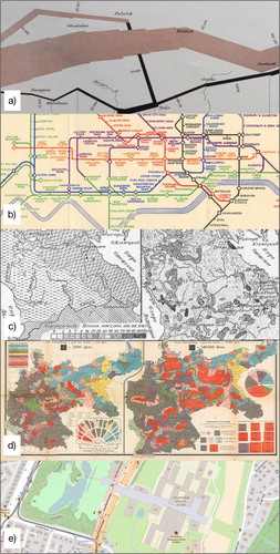
Flow maps crafted by civil engineer Charles Minard are early examples of cartographic innovations in thematic mapping (Palsky, Citation1996). Salient amongst Minard’s many graphic innovations is his multivariate flow map from 1869, depicting Napoleon’s fatal Russian campaign in 1812 ((a)). This particular map has been popularized by Tufte (Citation1983) for the English-speaking audience and is today often cited as a design classic. Minard might be the most well-known ‘flow map author’, the first known flow map was drawn by Henry Harness in 1837 (Robinson, Citation1982). This type has seen a recent revival due to the increased availability of massive amounts of collected human mobility data of all kinds (Kraak, Citation2014a). Another design classic related to human mobility is Harry Beck’s 1931 public transportation map of the London Underground (Garland, Citation1994), used today by millions of commuters all over the world ((b)). Whether or not Beck might have been inspired by a previously published transportation map for the Berliner S-Bahn network in 1931 is still debated today (Ovenden, Citation2007) (http://www.berliner-verkehr.de/netze/_Netze/Netz_1931_klein.gif). At any rate, this kind of highly abstracted network diagram has set a standard for public transport mapping to this day.
The dasymetric mapping technique, certainly less known in the design or visualization communities beyond cartography, is another early cartographic innovation from at least nineteenth-century Europe (Fabrikant, Citation2003) which has recently gained a revival, due to the digital revolution, and the development of spatial analytical techniques within the context of geographic information systems ((c)). The dasymetric map proposed in 1911 by Benjamin Semenov-Tian-Shansky for a large Russian mapping project published in 1919 features several geovisual analytical innovations, such as statistical isoline mapping for thematic map data, map overlay analysis including density reallocations based on ancillary data, dot mapping and regular spatial tessellations (Petrov, Citation2012).
Yet another cartographic design classic known as value-by-area cartogram (Dent, Citation1998) has seen a recent renaissance in election mapping, due to digitization and digital data availability (e.g. Gastner & Newman, Citation2004). Probably one of the first published contiguous area cartogram examples is the human population cartogram serving as a geographic summary of the party composition of the German Reichstag elections in 1902. Interestingly, this cartogram is appropriately juxta-posed by a traditional value-by-land area map on the same fold-out page as shown in (d). This allows a reader to immediately appreciate the distortions in land area of the German Census zones, based on mapped population magnitudes (Haack & Wiechel, Citation1903).
Societal needs and technological innovations have always had an enormous influence on developments in cartography. For example, since 2005 Google have facilitated free and near universal access to maps with their easy-to-use interactive, online map interface, especially used for everyday locational reference, routing and navigation. This is of course only to users who have access to a working Internet connection with sufficient bandwidth. Simple online mapping interfaces running in a web browser were already known and used prior to 2005, for example, the online route planner idea was first promoted by Mapquest already in 1996, but at that time knowledge of and access to the web were still limited. Computer animations are another example. They feature prominently in television’s daily weather news, while their interactive equivalents are available online anytime. However, such developments have also created high expectations amongst the general public who now ask questions like ‘Is this happening in real-time?’ while looking at satellite imagery showing dynamic weather patterns. Nowadays, in the era of Web 2.0, the general public is invited to participate in geographic data creation and dissemination through all sorts of mapping solutions. Crowd sourced products like OpenStreetMap (http://www.openstreetmap.org) and many other thematic web maps such as Nature Today (https://www.naturetoday.com/intl/en/home) are populated and updated by the general public, although this ‘public’ might not be a true sample of the general population both in composition and geographic spread.
In our ever-changing world, the view on cartography and its featured product ‘the map’ have also undergone many transformations; in essence, mirroring the so-called spatial turn in society. The traditional ‘authoritative’ view of the map being a carefully crafted product by the cartographer, aimed at visually communicating a complete, mostly static database of known geographic facts to a user, has turned into a participatory and collaborative perspective. The map has moved beyond the static window to the world and become an interactive, mobile, dynamic and collaborative interface between a human, groups of people and the dynamically evolving environment. The map is used to explore and filter spatial information, to share spatio-temporal information and human behavior, and to show the geographic essence in multiple visuo-spatial alternatives. The maps facilitate users to engage with reality, modify their spatio-temporal behavior in real-time, change perspectives, analyze data, get new insights and maps support users in all kinds of spatio-temporal decision-making.
What positive impact can these developments have on society? In 2015, the United Nations set the 2030 agenda for sustainable development. By defining 17 sustainable development goals linked to 169 targets, it is hoped to stimulate action over the next 15 years to improve economic, social and environmental aspects of humanity and our planet (https://sustainabledevelopment.un.org/post2015/transformingourworld). The attainment of the targets is judged based on over 300 indicators. For instance, for the education development goal, one of the targets is to ensure that all children have free and good primary and secondary education. Its success is measured by two indicators ‘Percentage of children proficiency in reading and mathematics’ and the ‘Completion rate (primary, lower secondary, upper secondary)’. How can we cartographers be relevant to society in helping to reach these targets? First, well-crafted maps can effectively visualize currently known facts, and online mapping technology can disseminate these facts globally to increase awareness of the current state of affairs. Maps can be used to show the current status, and future maps can document changes over time. Interactive map dashboards connected to geographic databases at multiple scales and equipped with space–time analytical functions will allow decision-makers on various decision levels to monitor and compare indicators for policy development and action at various geographical scales. In the next section, we first review past definitions of the map and go on to propose a new definition for the scientific map concept.
As reviewed above, cartographic innovations are driven by changing societal needs and respective technological developments happening mostly outside of cartography. These changes, however, have also influenced the definitions of the map, as objects of study from within the cartographic discipline over time, as we detail below.
2. The map
In academic cartography, for a long time, the map has not only been the product, but also the object of scientific study (Eckert, Citation1921/Citation1925). The current International Cartographic Association (ICA) strategic plan offers a definition of the map concept that has evolved over time. The map is currently defined as follows: ‘A map is a symbolized representation of geographic reality, representing selected features or characteristics, resulting from the creative effort of its author’s execution of choices, and is designed for use when spatial relationships are of primary relevance’ (http://icaci.org/strategic-plan).
In this definition, the map as object of scientific interest includes the symbolized representation of spatial relationships. Interestingly, the graphic aspect of the map is only implicit in this definition. Perhaps, by intention, the word representation is meant to include the multimodality of map products available today: sonified displays, auditory verbal navigation instructions, virtual worlds, tactile maps, smell maps, map movies, etc. Moreover, with the recent inspiration of human factors and neuro-cognitive research in cartography, the internal ‘map in the head’, thus internal map representation, is also well captured. All prior mentioned core components such as art (i.e. creative effort), science (systematic and reproducible design for use) and technology (execution of choices and display mechanisms) are also contained.
Prior to this definition, the ICA promoted a map definition proposed by Board (Citation1990) which seemed to have appeared first in a report of the working group on cartographic definitions (Board, Citation1990). In this report, the map is defined as ‘a representation or abstraction of geographical reality: a tool for presenting geographical information in a way that is visual, digital, or tactile’. Clearly, the map was seen at this time as a communication tool (technology) that includes multimodal ways of representation (art), without any explicit references to science or use. Going further back in time, ICA’s Commission II, then responsible for the Multilingual Dictionary of Technical Terms in Cartography proposed the following map definition: ‘A representation, normally to scale and on a flat medium, of a selection of material or abstract features on, or in relation to, the surface of the earth or of a celestial body’ (ICA, Citation1973).
At this time, the visual aspect of the map is again only implicit, captured in the concept of representation. Perhaps representation at that time was seen equal to visual depiction. Technology at this time related to clearly to a flat medium.
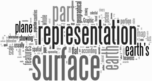
Many other definitions of a map exist. For example, there is the definition found in The History of Cartography Encyclopedia where Woodward and Lewis (Citation1998) define the maps as: ‘graphic representations that facilitate a spatial understanding of things, concepts, conditions, processes, or events in the human world’. Interestingly, the emphasis here is on the result of map use: human understanding of reality. A brief definition provided by Robinson and Petchenik (Citation1976) suggests the map to be ‘a graphic representation of the milieu’. A historical overview, including 321 map definitions, is provided by Andrews (Citation1996). This list is visualized in a Wordle in . On a side note, it is notable that in the English language the term chart is also used to specifically identify (aero)nautical maps from other map types.
Figure 2. The basic keywords of cartography represented in a Wordle, based on over 150 definitions provided by cartographers attending the ICC 2013 in Dresden, Germany.
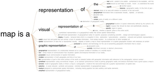
To reflect current societal and technological developments, we propose a new definition for the map concept below, both inspired by Robinson and Petchenik’s (Citation1976) concise definition cited above, and by the result of a crowdsourcing exercise with 120 cartographers during the Dresden ICC in 2013. summarizes the collected terms of this survey (Kraak, Citation2014a).
Figure 3. Results of the Map definition survey.
We thus define the product of art, science and technology and the object of scientific study of cartography in a digital information society as follows:
A map is a visual representation of an environment
In summary the map is …
‘Visual’ because it acts most often as a visual interface to a virtual or real environment, and shows only a selection thus an abstraction of the envisaged environment.
‘Represented’ thus like the environment, but not the environment itself. The representation can include semantic and semiotic mappings, metaphors, symbolization, scale change, variable dimensionality, tapping into varying sensual modalities, etc.
an interface to an ‘Environment’ which could be a dynamically evolving situation, geographic reality, perceived or cognized reality, virtual, artificial or a simulated environment, etc.
Compared to prior map definitions this less-specified new definition can thus also include the dynamic nature of experienced reality. Temporal aspects are especially important today, given that we live in increasingly mobile information society, and thus concepts such as process, change or time can be subsumed without having to explicitly mention it in the definition. This definition is thus similar to the map definition proposed by Woodward and Lewis (Citation1998) proposal, who emphasized the aim of a map: the human understanding of a dynamic world.
This definition is also broad enough to flexibly include current, rapid advancements in geographical information technology and respective research developments in GIScience, aimed at better supporting space–time big data analytics including movement analyses, change detection, process modeling, dynamic and interactive multi-dimensional visualization.
We started our discussion with maps as products of societal interest and concerns and looked at the changing definition of the map over time. Of course there is a scientific endeavor concerned with the study and development of systematic, reproducible and transparent procedures of making maps: the academic discipline of cartography to which we turn next.
3. Cartography
One might argue that cartography is what cartographers do. Turning to the Oxford Dictionary one can find cartography being defined as the ‘the science or practice of drawing maps’. The Encyclopedia Britannica is somewhat more specific on what cartography is, namely ‘the art and science of graphically representing a geographical area, usually on a flat surface such as a map or chart’. Changes in definitions of concepts and terms are not only based on publication type and ownership differences but of course also a reflection of a changing society producing them. Definitions are often influenced by societal trends or by the perspective from which one looks at the domain. When the computer started to play a prominent role in the cartographic workflow Guptill and Starr (Citation1984) suggested:
the information transfer that is centered about a spatial data base which can be considered in itself a multifaceted model of geographic reality. Such a spatial database then serves as the central core of an entire sequence of cartographic processes, receiving various data inputs and dispersing various types of information products.
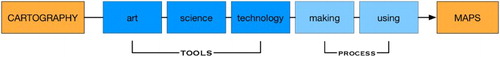
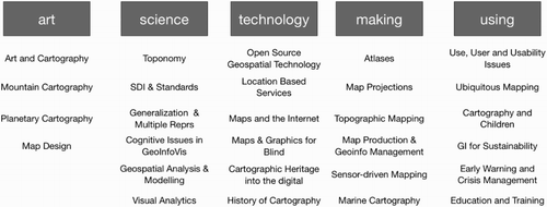
Of course, many more definitions exist, but here we will look at the definition found in the strategic plan 2003–2011 of the International Cartographic Association (http://icaci.org/strategic-plan). There it is written: ‘Cartography is the art, science and technology of making and using maps’. The basic keywords in this definition are widely known in the cartographic community, as can been seen in the Wordle in . It is based on the responses of over 150 participants of the 2013 International Cartographic Conference (ICC) in Dresden who were asked to give their definition of Cartography (Kraak, Citation2014b). Let us take a closer look at the individual keywords following the diagram in , which shows the definition as a flow chart, where art, science and technology represent the tools of a cartographer, and making and using the process of engaging with a cartographic product. For the origin of the word cartography, see van der Krogt (Citation2015). Let us take a closer look at the elements of the ICA definition.
Figure 4. Wordle map definitions (http://www.maphist.nl/discpapers.html).
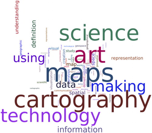
Figure 5. The definition cartography represented as a flow chart with the keywords art, science, and technology as the cartographer's tools and making and using as the process of engagement with a cartographic product.
3.1. Art
Maps are loved by almost everyone. This positive attitude toward maps is often due to their attractive appearance. Artistic style refers to the appearance of the map. Artistic characteristics of a map can transport attitudes, emotions, human engagement, but also authoritative detachment or corporate identity (Ory, Christophe, Fabrikant, & Bucher, Citation2015). Art stands for diversity. Although it might be confusing for a casual map user, many appropriate designs of the same data can co-exist. A well-designed map will stimulate engagement with the depicted data, in other words, it draws people into the presented data space, and it might serve as a first step to understanding. Of course, an attractive map should engage a viewer, but not at the cost of distracting the map user from its intended message.
3.2. Science
The nature of the data to be mapped dictates the construction of the appropriate cartographic representation, that is, the map type, and its respective symbology. The foundations for such cartographic guidelines have been proposed by Bertin (Citation1967). He suggests a systematic (carto)graphic analysis by linking the nature of the data (e.g. discrete vs. continuous phenomena, qualitative, vs. quantitative data, etc.) with perceptual properties of map symbols and their variations. While Bertin’s approach was mainly intuition based, most of his ideas have begun to be verified empirically (Garlandini & Fabrikant, Citation2009) and are being supported by developments in other scientific domains including psychology, vision science and cognitive science. Bertin’s original ideas have also informed and been further developed by cognate fields in information science and computer science (Börner, Citation2014).
3.3. Technology
Technological innovations and change influence the construction methods and dissemination mechanisms of maps. In the past, typically few of us consumed maps and those consumed were mainly on paper. Today, it is almost all about web services on digital devices for the masses. This is further stimulated by developments concerning the Internet of things, mobile systems, and graphic display technology and standards. Cartographers are quite eager to experiment with new opportunities to create maps faster than before, graphically more sophisticated than ever before, or personalized, with many graphic alternatives. Technological change is exciting and might drive product development and dissemination at an increasing pace. However, it is important to consider to the gap that might broaden between what technology might offer and cartographic science, and empirically validated theory development, suggesting what might be desired (Ormeling & Kraak, Citation2008).
3.4. Making
In the past, only professional cartographers would have had access to geographic data and only they were trained professionally to produce maps. More recently, we have witnessed an increase in (open) data availability and online versions of sophisticated GIS and mapping software for non-trained cartographers with access to an Internet connection to create their own maps. Not only researchers in the geographic sciences with an increased incentive for visualizing and sharing their complex datasets, but also the general public have seized the opportunity for do-it-yourself map making. Nowadays, data journalists working for online mass media have become the new cartographers for the masses, developing attractive looking interactive multimedia documents of current events. As a result, the number of maps created today can be rather overwhelming, but their communicative quality is not always convincing. Smart devices connected with the Internet have again multiplied the number of maps made; they often also directly influence human spatio-temporal behavior (e.g. navigation). The public is stimulated, and sometimes even trained, to make their own maps by participating in crowd sourced mapping projects. However, just because one can more easily map today, this does not necessarily mean one should. In such developments, one might still distinguish between professional cartographers and what we call mapmakers. Mapmakers, for example, a (geographic) scientist or the crowd, will often use professional web map services in combination with their own data, and render this data with ready-made symbolization or templates via so-called map mash-up technology. Due to their formal cartographic training, professional cartographers might be critical in developing engaging and expressive future mapping technology and map service solutions that might be perused by crowd mappers. Technologically savvy cartographers armed with an affinity to artistic expression will be able to effectively transfer the advancements of cartographic science, that is, their knowledge of empirically validated cartographic theory into current and future mapping technology.
3.5. Using
In the past, map users where considered as a homogeneous, often abstract and unknown information recipient group. Inspired by developments in human factors and human–computer interaction research, and recent technological advancements in personalization this has changed considerably. The use and usability of maps is the focus of many scientific research projects in cartography. New cartographic products are developed based on user requirement studies that involve the user right from the beginning of the design process, and by having the information needs and respective questions of the users in mind while developing map display solutions. As the crowd is increasingly engaged in map-making projects, the map user is now often the same person as the mapmaker.
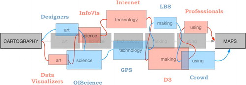
All kinds of societal and technological developments, both within and outside our scientific domain have, over time, allocated our professional attention and resources in different ways. Still, the definition of cartography offered in proved to have had enough elasticity to be called stable. As shown in , the five keywords in the above-mentioned definition have each been pushed and pulled apart in different directions, and been considered more or less important over time. One can witness that there have been periods when the aspect of art was neglected in favor of science, and that technology has always received significant attention. This perhaps as it offers direct ways to transfer theories or apply novel approaches for use to society. We are now at a juncture of significant current opportunities, and future challenges for the cartographic discipline, as the process of making and using maps has received more attention than ever before, as more and more people globally look at, consume, create and share maps.
Figure 6. The external influences and elasticity of the cartographic definition. The red and blue flows each represent a certain moment in time when external and internal forces, represented by the red and blue keywords have been at work.
Next, we analyze the structure and activities of the ICA over the recent past with the aim to further understand the professional development of the cartographic discipline.
4. International cartographic association
Developments in cartography can be nicely illustrated by the structure of its professional organization: the ICA, its members and respective activities over the last six decades. We review all these developments by adopting both an overall perspective, to track the name and composition of ICA’s Commissions and Working Groups between 1964 and 2015, and also bottom-up, on a more detailed level, based on the publications produced for the ICCs between 1993 and 2013. Obviously, there is a direct relation between the two as the Commissions and Working Groups are the driving force behind the ICA conference topics.
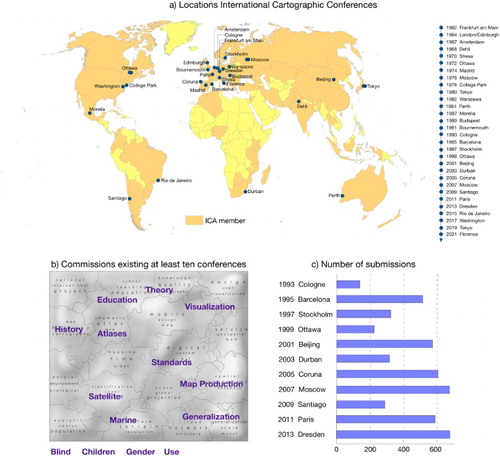
(a) shows the increase in the number of Commissions and Working Groups over time. In 1964, there were only three active Commissions, but in 2015 ICA features 27 Commissions and 3 Working Groups. It should be noted that Commissions are proposed bottom up, and voted for every four years, at the ICA’s General Assembly by the delegates of the member nations. In contrast, Working Groups are installed top-down by the ICA Executive Committee. What could be the reason for this recent increase in Commissions and Working Groups? On the one hand, we can happily note that the discipline of Cartography has significantly diversified its (research) portfolio since 1964, thus resulting in a more granular research landscape justifying the need for new Commissions. On the other hand, the ability to travel to conferences for sharing research interests and ideas across the globe seems to have increased, possibly due to reductions of travel costs. This at least for member nations with respectable travel budgets. The increased availability of digital mailing lists and modern (virtual) communication techniques might also have contributed to this increase. A more global reach and broad participation in conferences and commission activities bring together a greater diversity of researchers, practitioners and government officials for cartographic knowledge exchange. Of course, a focused commitment of a particular member nation, with a long-established cartographic track record or a particular chair person might be another driving force behind a particular Commission proposal and respective activities.
Figure 7. ICA’s Commissions and Working Groups over time.
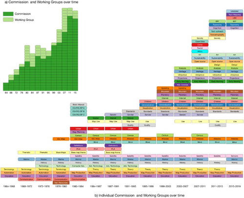
(b) offers more detail on the individual Commissions and Working Groups responsible for cartographic (research) activities within the ICA. The Commission names have been simplified to fit into the boxes. One has to realize that subtle changes of a Commission name over time might have quite some effect on the directions of respective activities pursued by the Commission. For example, in 1995, the Commission on Visualization came into existence, and its name has not only seen regular semantic changes since then, but also respective re-orientation of research activities and research directions. The sequence of name and content changes of the Visualization Commission included Visualization and Virtual Environments, followed by Geovisualization, and is currently Visual Analytics. Other Commissions names have been more persistent over time, despite changes in the leadership and thus can be interpreted as having been thematic cores to the ICA’s mission such as the Education and Map Production Commissions. Similarly, the Marine and History Commission have had stable existences (12 out of 14 periods). The top right of the diagram shows a large increase in Commissions in more recent times, and typically feature contemporary ‘hot’ topics such as open source, location-based services and society. Other Commissions only existed for a single period. This can mean the topic experienced a sudden burst of interest, spurred by a societal trend or hype, but it could also mean that there was no ICA member nation interested in continuing this topic. Interestingly this seems to be even the case for an important topic such as cartographic theory. It might also simply mean that theory is a core theme for many Commissions and tightly connected to the Commissions thematic focus and thus does not need to have a separate, isolated Commission in its own right.
indicates how the current Commission and Work Group activities relate to the domain definition listed in . The location of a Commission or Working group in the diagram is based on how their terms of reference match to the respective keywords. Clearly, only few Commissions will chiefly work on a single keyword. More often than not, several Commissions work on various keywords jointly.
Figure 8. Commissions and Working Groups in 2015 and how they are associated with the definition of cartography.
One might ask how the leadership and structure of a self-organized professional organization might reflect or shape artifacts and activities produced by its members. In the case of the ICA, this might also mean the intellectual development of cartographic research themes and areas, for instance, as emerging from papers presented at its biannual ICCs over the past years. maps an intellectual landscape of our discipline based on 4922 paper titles and abstracts (only in English) that have appeared in past 11 ICC proceedings 1993–2013 (Deseoe, Citation2015).
Figure 9. Thematic Landscape of the International Cartographic Conferences 1993–2013. Thematic clusters emerging 4906 proceeding contributions for the past 11 ICA Conferences (Figure based on Deseoe, Citation2015).
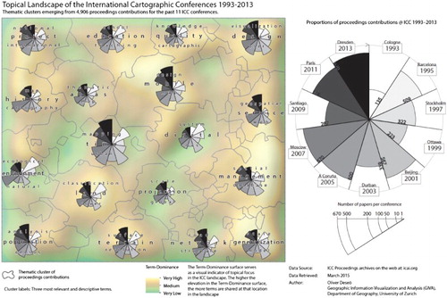
We followed the intellectual knowledge visualization process as proposed by Fabrikant and Salvini (Citation2011) who have already spatialized the content of ICA submissions 1999–2009. We complemented this already pre-processed and readily available database containing the titles and abstracts of submissions in English, with additional data obtained from the ICA publications archive online (http://icaci.org/publications). We thus processed 5105 proceeding submissions in total, of which only 4922 could be considered for further analysis, due to submissions in languages other than English that would have made automated semantic analyses impossible. We thus removed submissions in French (147), Spanish (25) and in the German (11) language from the database. From the remaining 4922 submissions, we eventually processed those that had a title and an abstract in English, including 420 papers (8%) that did not have an abstract. We compiled additional metadata including the author names, the location of the conference and the year of the submission. Following prior related work, we ran a Topic Model algorithm available in the MATLAB Toolbox TVT (Hespañha and Hespañha, http://www.ece.ucsb.edu/~hespanha/software/textvistools.html) on our unstructured text database. We chose a topic solution including 20 topics, as related work suggests for this kind and size of text database (Bruggmann et al., Citation2013).
Inspired by Skupin and De Jongh (Citation2005), and applying the empirically validated spatialization framework by Fabrikant and Skupin (Citation2005), we projected the resulting 20-dimensional topical database into a 2-dimensional self-organizing map (SOM) display, to further reduce data dimensionality, and to make the ICA database cognitively and perceptually accessible for visuo-spatial human exploration. Finally, we applied the Blondel Community Detection algorithm to delineate thematic clusters of papers with high semantic similarity in the ICA publication landscape, and to visualize these thematic regions in the SOM. The region labels are automatically generated by means of the tf/idf method, generating lists of words that best describe the regions. We show only the three most descriptive terms of each region, and these, weighted by importance, were determined by human raters (Deseoe, Citation2015). In , we can see that related cartographic themes are also in close distance in the thematic landscape, for example, time, mobile, digital and web service.
The regions in the center of the map share more similar terms with their neighboring regions than regions at the edges of the knowledge terrain. We show topical breadth and depth using the concept of term dominance used by Fabrikant and Skupin (Citation2005), and visualize it as a shaded relief in the Swiss relief manner. Term dominance is determined by word frequency comparisons, that is, most frequently used words in papers associated with neurons in the SOM are compared to all words occurring at that neuron location. The shaded relief is the result of a kernel density estimation based on SOM neurons with associated term dominance values. Hence, peaks in the term dominance surface suggests a topical focus or greater semantic depth in that only few, but frequently used terms describe the papers at that neuron location adequately. In contrast, the plains and valleys in the ICA publication landscape represent areas with low term dominance. These areas show neurons with associated papers that contain a greater term variability, and thus greater semantic breadth, compared to the peaks in the landscape. For example, the term dominance peak in the region labeled design|mobile|map suggests that this area of the ICA publication landscape has papers with a narrower semantic focus than the region scale|projection|gobal. This difference in breadth and depth is already captured by the three selected terms by human raters. The graduated wing charts depict the number and proportions of proceedings contributions across the years associated with each thematic region. One can immediately see that whereas the absolute number of submissions has increased over the years, this has not happened linearly, but outliers might be associated with a particular conference location or the acceptance rates by conference organizers. For some reason, Stockholm (1997), Ottawa (1999), Durban (2003), and Santiago de Chile (2009) show reduced submission numbers. shows the ICA landscape evolving over time.
Figure 10. ICA publication landscape evolving over time (1993–2013) (Deseoe, Citation2015, p. 34). Author’s own.
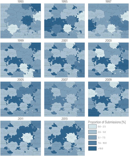
The shading of the thematic regions shows the proportions of conference contributions, in percent, associated with each theme over time. For example, as expected the most recent conferences (2011–2013) show largest proportions of contributions in the regions labeled mobile|design|map and mapping|time|urban. This is contrasted by the period 2001–2003 for instance, where the themes mapping|time|urban, and spatial|management|database show highest submission proportions.
Not surprisingly, the theme service|geospatial|web theme only receives significant submission proportions after the turn of the millennium. Societal influences are also tractable in the thematic ICC submission landscape, given that the region ecological|natural|environment is salient in 1997, the same year the Kyoto Protocol was ratified.
focuses on ICA’s ICCs. At the top it shows the location and timeline of all conferences. For the period 1993–2013, it links those Commissions to the ICA spatialization in that were active for at least 10 of the 11 conferences in that period (see ). Not all Commission foci are directly apprehensible in the publication landscape. There are several explanations for this. Firstly, not all ICA Commissions are equally focused on research activities that directly yield publications in refereed conference proceedings, or and/or they might represent only a small group of ICA members or ICC conference attendees. Other reasons might include research of Commissions that are very broad, and might touch on many themes in the landscape, thus appear in many regions in the publication landscape. For example, the Commission on Map Use (and User Issues) now called Use, User, and Usability Issues is represented in the upper right corner of the landscape in with labels design|user|visualization. Clearly, research on user issues is also found in the regions labeled mobile|design|map and mapping|time|urban, etc. Similarly, publications related to the Commission on Children or Satellite can be localized in several thematic regions.
Figure 11. ICCs: (a) the location of the ICCs; (b) the relation between the Commissions and the spatializations of the conference content; (c) number of submission of the selected conferences. Author’s own.
5. Discussion
We started our contribution by first highlighting a small selection of salient ‘landmark maps’ in an ever-evolving dynamic landscape of cartographic innovations. These salient maps communicate how changing societal needs and respective technological developments have influenced cartography and the definition of its respective objects of study – the map – from within and from the outside of the cartographic discipline. Inspired by this historical review, we propose a new definition for the map concept by extending Robinson and Petchenik’s (Citation1976) concise definition with the results of a recent crowdsourcing exercise sampled from participants within our discipline. In condensing the collected responses, we aimed for a concise, but inclusive definition, which might be able to flexibly adapt to pushes and pulls over time, from both the inside and outside of our academic community, as shown in .
We then review a series of changing definitions of cartography, a further reflection of societal changes and technological innovations mirrored in the discipline.
A resilient definition for cartography does not have to mean stagnation or that change should not be welcomed. On the contrary, a strength of cartography might precisely mean to constantly adapt to societal and technological change, without compromising on fundamental cartographic values. It is necessary to continuously develop solid cartographic theory, supported by sound empirical evaluations, as to best take advantage of currently available, and newly opening data sources, and rapidly advancing technology in the future. With this in mind, we recently revisited ICA’s fundamental building blocks, that is, the art, science, and technology, of making maps in a Cartographic Summit (http://www.esri.com/events/cartographic-summit/), together with various members from cognate fields. This included scientists and practitioners from the graphic design sciences (i.e. art), the data visualization (i.e. science) and the digital media (i.e. technology) communities. During this event, that brought together academic and non-academic cartographers and self-made mapmakers, data scientists and information visualizers, digital media journalists and graphic designers, we discussed how current converging and future technology developments in data collection and dissemination, design methods and tools, and emerging communication channels in the mass media might influence the future of cartography. Current massive amounts of collected data require solid data science skills including programming, database management, data processing and data analytics to efficiently and effectively deal with the variety of available data sources (pull factors). Knowledge in automated data-processing methods will free up the time necessary to deal with advanced cartographic design challenges, due not only to the complexity and the increasingly dynamic nature of the big data sets cartographers need to handle, but also the responsive and dynamic nature of the display media (push factors). Inspired by graphic artists and designers, we need to be continuously reminded that clarity should be the utmost important characteristic of all our cartographic products irrespective of the data challenges. Future maps will be more diverse in data, more personalized, and thus more user focused than before. Cartographers will increasingly have to consider issues of privacy, and perhaps will need to carefully communicate the (private) story (hidden) in the data. The past can indeed be a useful guideline to the future. Hence, the idea in this contribution to revisit cartographic design classics, as depicted in . To be able to translate today’s available data and mapping needs into similarly salient landmark displays of cartographic innovation, a closer cooperation among the data scientist, artist and graphic designer, information visualizer, mass media expert and cartographer seems necessary. Transdisciplinary cooperation is, of course, not new for cartographers. We have learnt from and been inspired by others over history, as the maps in expressively illustrate. We have adapted to new technologies, as the cartographic definitions reviewed earlier suggest, and today, we also feature a strong body of science to support us in these endeavors.
The ICA’s composition of Commissions, and the people who are active in these Commissions bring academics and practitioners together with mixed backgrounds, diverse cartographic needs and broad skill sets, all contributing to the developing academic cartographic landscape (). It is important for the future development of the ICA to further seek transdisciplinary collaborations with professional sister societies, and mapmakers from cognate disciplines such as information visualization, for instance.
The Commissions’ mere existence guides the topic list in the call for papers of the conferences. But geography also matters. The location of the conferences has probably had its influence on their attendance and submissions numbers, as do the ‘home countries’ of the leadership of the Commissions or the majority of their members. In some occasions, where the host country of the conference is non-native English speaking, paper submissions in that local language is not represented in the mapped academic cartographic landscape shown in . This, for instance, happened for the submissions in Spanish for ICC in Santiago de Chile (2009), in French for ICC Paris (2011), in German for ICC Dresden (2013) and in Portuguese for the ICC in Rio de Janeiro (2015). As suggested by Fabrikant (Citation2003) at times, due to communication difficulties across linguistic zones, developments and research innovations in cartography have happened in isolation or in parallel in different parts of the world in past. This is one reason, why we aimed to specifically include references to research in this paper, in languages other than English.
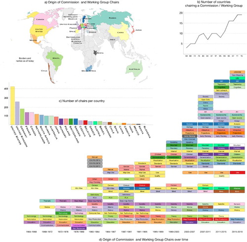
Over time, we can further witness an increase in the number of countries that have active members in the ICA with roles in the Executive Committee or as a Commission or Working Group chair. (a) highlights the countries that have been represented in the role of Commission and Working Group chairs. The graph in (b) depicts the increase in the number of countries actively involved in the ICA, and the bar graph shows how many Commission chairs each country has had over the years. (d) similarly to includes a time line representing the periods of existence of Commissions and Working Groups over time. The colors refer to the country of origin of the Commission chairs.
Figure 12. Geography and the Commissions and Working Groups: (a) Countries represented by Commission and Working Group chairs; (b) number of involved countries over time; (c) Number of chairs per country; (d) Geographic distribution of the chairs over time. Author’s own.
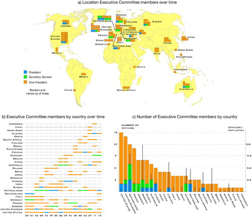
highlights the role and geographical distribution of the ICA’s Executive Committee members over the years. The map highlights the countries that have been represented in a particular leadership role (i.e. president, secretary-general, or vice president) over the years. The time line chart represents the leadership type and duration for each contributing country. The bar graph shows the total number of ICA officers per country, the proportion of officers based on the country’s population. Non-surprisingly, European nations seem to be over represented in the ICA leadership, which can be explained by the specific history of cartography, but probably also because Europe makes up the majority of ICA’s global membership. Surprisingly, nations with smaller population numbers such as Sweden, the Netherlands and the Czech Republic exhibit a relatively high proportion of ICA officers, while member nations with large population numbers including China, Russia and the United States represent a relative small proportion of the ICA officers.
Figure 13. The Geography of the Executive Committee: (a) geographic origin of the Executive Committee members; (b) members by country over time; (c) total number of members per country, and the respective proportion of the country’s population. Author’s own.
Although cartographers have always embraced external influences, as detailed earlier, we do realize that above deliberations centered on definitions stem from an inside perspective, possibly considered biased. We did this deliberately, taking advantage from a long-standing, and rich disciplinary history, and also inspired by its perdurance product the map. Both the map and the discipline evolved over time with and have been stimulated by the activities of the ICA.
6. Summary and outlook
A flexible cartographic discipline is ready for tomorrow. However, a resilient and forward looking discipline has to continue to be inclusive, innovative and open to change, so that we can keep handling societal and technological transformations, without compromising on fundamental cartographic values. We recently witnessed a rapid transformation from the static paper map into a digital, interactive, mobile, dynamic, responsive and collaborative interface between a human or groups of people, and dynamically evolving environments. A forward-looking cartographic discipline has been encouraged, stimulated, steered and promoted by the ICA, whose Commissions and Working Groups pledge to make this happen in a truly global context.
In doing so, it will make our discipline influential in reaching the objectives of the United Nations Sustainable Development Goals. This, because effective map displays support the inventory, monitoring, and most importantly, foster understanding of the data related to the goals’ targets and indicators. Engaging map displays also offer different perspectives, help uncover hidden connections and reveal trends, and thus facilitate deeper insights and understanding to transform our world. Maps, in essence, have the power to make the world a better place.
Acknowledgements
The authors thank Igor Drecki, ICA News Editor, for data on the history ICA’s Executive Committee and Commissions and Working Groups and Oliver Deseoe for the spatializations of the ICA's proceedings.
Disclosure statement
No potential conflict of interest was reported by the authors.
Notes on contributors
Menno-Jan Kraak is professor of Geovisual Analytics and Cartography at the University of Twente / ITC and head of the Department of Geo-Information Processing. He is currently president of the International Cartographic Association.
Sara Irina Fabrikant is professor of Geography at the University of Zürich and head of Geographic Information Visualization and Analysis Unit. She is currently vice-president of the International Cartographic Association.
ORCID
Menno-Jan Kraak http://orcid.org/0000-0002-8605-0484
Sara Irina Fabrikant http://orcid.org/0000-0003-1263-8792
References
- Andrews, J. H. (1996). What was a map? The lexicographers reply Cartographica: The International Journal for Geographic Information and Geovisualization, 33(4), 1–12. doi: 10.3138/NJ8V-8514-871T-221K
- Bertin, J. (1967). Semiology graphique. Den Haag: Mouton.
- Board, C. (1990). Report of the working group on cartographic definitions. Cartographic Journal, 29(1), 65–69.
- Börner, K. (2014). Visual insights: A practical guide to making sense of data. Cambridge, MA: MIT.
- Bruggmann, A., et al. (2013). Cartograms of self-organizing maps to explore user-generated content. Proceedings, 26th International Cartographic Conference, International Cartographic Association, Dresden, Germany.
- Dent, B. D. (1998). Cartography: Thematic map design. Boston, MA: WCB/McGraw-Hill.
- Deseoe, O. (2015). Informationslandschaften im Vergleich: Thematische Karte vs. Reliefkarte. (Unpublished master’s thesis), Department of Geography, University of Zurich, Zurich.
- Eckert, M. (1921/1925). Die Kartenwissenschaft. Berlin: DeGruyter.
- Fabrikant, S. I. (2003). Commentary on “a history of twentieth-century American academic cartography” by Robert McMaster and Susanna McMaster, special issue: Exploratory essays: History of cartography in the twentieth century. Cartography and Geographic Information Science, 30(1), 81–84. doi: 10.1559/152304003100010965
- Fabrikant, S. I., & Salvini, M. M. (2011). Charting the ICA world of cartography 1999–2009. Proceedings, 25th international cartographic conference, international cartographic association, Paris, France.
- Fabrikant, S. I., & Skupin, A. (2005). Cognitively plausible information visualization. In J. Dykes, A. M. MacEachren, & M. J. Kraak (Eds.), Exploring geovisualization (pp. 667–690). Amsterdam: Elsevier.
- Garland, K. (1994). Mr. Beck's underground map. London: Capital Transport Publishing.
- Garlandini, S., & Fabrikant, S. I. (2009). Evaluating the effectiveness and efficiency of visual variables for geographic information visualization. Proceedings, lecture notes in computer science 5736 / Spatial information theory: 9th international conference, COSIT Aber Wrac’h, France, Springer: 195-211.
- Gastner, M. T., & Newman, M. E. J. (2004). Diffusion-based method for producing density-equalizing maps. Proceedings of the National Academy of Sciences, 101, 7499–7504. doi: 10.1073/pnas.0400280101
- Guptill, S. C., & Starr, L. E. (1984). The future of cartography in the information age. In L. E. Starr (Ed.), Computer assisted cartography research and development report. ICA commission C (pp. 1–15). Washington, DC: ICA.
- Haack, H., & Wiechel, H. (1903). Kartogramm zur Reichstagswahl. Zwei Wahlkarten des Deutschen Reiches in alter und neuer Darstellung mit politisch-statistischen Begleitworten und kartographischen Erläuterungen. Gotha: Justus Perthes Verlag.
- ICA, C. I. (1973). Multilingual dictionary of technical terms in cartography. Wiesbaden: Steiner.
- Kraak, M. J. (2014a). Mapping time, illustrated by Minard’s map of Napoleon’s Russian campaign of 1812. Redlands, CA: ESRI Press.
- Kraak, M. J. (2014b). ICA survey on definitions. ICA News. Auckland, ICA, pp. 7–8.
- Kraak, M. J., & Ormeling, F. J. (2011). Cartography visualization of spatial data. New York, NY: Guildford Press.
- van der Krogt, P. (2015). The origin of the word ‘cartography’. e-Perimetron, 10(3), 124–142.
- Ormeling, F. J., & Kraak, M. J. (2008). Maps as predictive tools – mind the gap. Cartographica: The International Journal for Geographic Information and Geovisualization, 43(3), 125–130. doi: 10.3138/carto.43.2.125
- Ory, J., Christophe, S., Fabrikant, S. I., & Bucher, B. (2015). How do map readers recognize a topographic mapping style? The Cartographic Journal, 52(2), 193–203. doi: 10.1080/00087041.2015.1119459
- Ovenden, M. (2007). Transit maps of the world. London: Penguin Books.
- Palsky, G. (1996). Des Chiffres et des Cartes: Naissance et développement de la Cartographie Quantitative Francais au XIXe siècle. Paris: Editions de CTHS.
- Petrov, A. (2012). One hundred years of dasymetric mapping: Back to the origin. The Cartographic Journal, 49(3), 256–264. doi: 10.1179/1743277412Y.0000000001
- Robinson, A. H. (1982). Early thematic mapping in the history of cartography. Chicago, IL: University of Chicago Press.
- Robinson, A. H., & Petchenik, B. B. (1976). The nature of maps. Chicago, IL: University of Chicago Press.
- Skupin, A., & de Jongh, C. (2005). Visualizing the ICA – A Content-based Approach. Proceedings of the 22nd International Cartographic Conference, La Coruña. Spain.
- Taylor, D. R. F. (1991). Geographic information systems: The microcomputer and modern cartography. In Geographic information systems. Oxford: Pergamon Press.
- Tufte, E. R. (1983). The visual display of quantitative information. Cheshire, CT: Graphics Press.
- Wolfe, J. M., & Horowitz, T. S. (2004). What attributes guide the deployment of visual attention and how do they do it? Nature Reviews Neuroscience, 5(6), 495–501. doi: 10.1038/nrn1411
- Woodward, D., & Lewis, G. M. (1998). The history of cartography. Vol. 2, book 3: Cartography in the traditional African, American, Arctic, Australian, and Pacific Societies. Chicago, IL: University of Chicago Press.