
ABSTRACT
The authors’ main aim is to offer an abbreviated background on the methods and solutions used to teach basic map concepts in three countries, based on the study of textbooks and workbooks related to Geography as well as school atlases. Firstly, a short history on the teaching of basic map concepts in our countries is given. It is followed by the presentation of map concepts taught currently in each country and in which grades can pupils learn those concepts. Next, authors reflected on some methods and solutions used to teach map concepts, presenting in more detail those solutions that in our opinion can contribute more effectively to arouse students’ interest in the use of maps. Some interesting exercises and practical activities are also described, making emphasis in the importance of the multidisciplinary teaching activities: acquisition or practice of knowledge related to maps in different subjects, introduction of new technologies and use of school atlases. Finally, authors presented the similarities and differences between our countries and highlighted the positive aspects of our teaching activities.
RÉSUMÉ
L’objectif principal est de proposer une vue synthétique des méthodes et solutions utilisées pour enseigner les concepts de base de la cartographie dans trois pays, à partir de l’étude de manuels et de cahiers relatifs à la géographie et d’atlas scolaires. Nous présentons en premier un bref historique de l’enseignement des concepts de base de la cartographie dans nos pays. Puis nous présentons les concepts cartographiques enseignés aujourd’hui dans chaque pays et précisons à quel âge les étudiants les apprennent. Ensuite nous réfléchissons aux méthodes et solutions utilisées pour enseigner les concepts cartographiques, en présentant en détail les solutions qui, à notre avis, peuvent contribuer plus efficacement à augmenter l’intérêt des étudiants pour l’utilisation de cartes. Quelques exercices et activités pratiques intéressants sont également décrits, en soulignant l’importance des activités d’enseignement pluridisciplinaire : acquisition ou pratique de connaissances liées à des cartes dans différentes matières, introduction des nouvelles technologies et utilisation des atlas scolaires. Enfin, nous présentons les similitudes et différences entre nos pays en soulignant les aspects positifs de nos activités d’enseignement.
1. Introduction
School Geography of Azerbaijan was established in the early twentieth century by the geographer Qafur Rəşad Mirzəzadə. Educative maps were produced within the first Geography textbooks, which constituted the beginning of the teaching of map concepts in Azerbaijani schools. Afterwards, Geography Institutes at universities started to train specialists, who lead the development of school textbooks, wall maps, and atlases between 1930 and 1990. Since the independence of Azerbaijan, map teaching methods and practice-oriented changes have been developing under the Geography subject and the curriculum in the early twenty-first century. The modern methods of teaching maps in elementary and secondary schools are performed by using several sources such as wall maps, textbooks, contour maps, atlases, etc (Seyfullayeva, Citation2017).
The first Hungarian textbook of Geography including maps was probably published in 1781. Its title was Introductio in geographiam Hungariae antiqui et medii aevi and contained twelve historical maps. Its author was a Lutheran pastor, János Tomka-Szászky, who probably made the maps in Bratislava some years earlier, in 1751. In the second half of eighteenth century, István Losonczi wrote the ‘Triple Mirror of Hungary’ that was a book on the history and geography of Hungary and Transylvania. The first edition appeared in 1770 including two very similar inset maps without any reference to their author (Klinghammer, Citation2002).
The publication of school atlases in Hungary is dated in 1800, when Professor Ézsáiás Budai created his ‘New School Atlas for elementary pupils’. During the next 90 years, the school atlases were mostly translations and adaptations of foreign atlases, the majority of which were made in German-speaking countries. In those years, a school atlas made by a Hungarian astronomer, Antal Vállas, should be highlighted as a prominent independent piece of work. The Hungarian Geographical Institute, founded by the cartographer Manó Kogutowicz in 1890, was the institution responsible for producing school atlases in the country for the next almost 30 years. The professional quality of their school atlases was also recognized beyond the Hungarian borders by prizes won in international exhibitions. These school atlases included also the graphic presentation of basic concepts related to orientation, maps, landforms, astronomy, etc and they laid the foundations of the current Hungarian school cartography (Klinghammer & Reyes Nunez, Citation2017).
The Ministry of Education (MOE) in the United Arab Emirates (UAE) offered Social Studies textbook starting from grades 4–6. Geography textbook was used from grades 7–10, and from grades 11–12 only for pupils who joined Social Sciences track. These textbooks were supplied in 1953 from the Ministry of Education in Egypt, Kuwait, and later from the Gulf Cooperation Council (GCC), the political and economic alliance of six Arab countries (Saudi Arabia, Kuwait, United Arab Emirates, Qatar, Bahrain, and Oman) (Ridge, Citation2011). Afterward, from the late 1990s and the beginning of 2000s, the MOE has worked to develop its curricula within a comprehensive development plan and in accordance with international best practices, which aims to prepare students for knowledge useful for the society in the twenty-first century, focusing on literacy skills and teaching based on diverse knowledge. The MOE has also worked on curriculum development plans to ensure that learning outcomes and curriculum standards are achieved. Since 2008, the Social Studies textbook began to be taught from the 1st year of Kindergarten to grade 12. Since the academic year 2015/2016, the Social Studies textbook has appeared in a new interdisciplinary version. Therefore, this textbook was divided into four parts including History, Geography, Economy, and National Education. There is no independent Geography subject anymore, because Geography was included in the Social Studies subject and textbooks. The topics associated with the Geography subject section are varied in all grades. The MOE does not publish any types of school atlas, while textbooks are purchased from Geography Publishing Houses.
Authors wish to give a general background on the teaching of basic concepts related to maps in their respective countries, making emphasis on when (specifically on which levels of education) can pupils learn the first concepts and begin to use maps. The selection of the countries presented in the article is based on two fundamental reasons: the first one is the interest in developing a research in three countries that traditionally have not maintained a close relationship between them through their history and for that reason the development of their educational systems have been independent of each other. The second reason is founded in the professional relationship between the authors, which arose (emerged) within the Commission on Cartography and Children of the International Cartographic Association (ICA) and during their contacts and exchanges of experiences as professors and researchers at their universities. Authors emphasized on the solutions used to present basic map concepts in textbooks, because they are published for pupils in the three countries examined. Workbooks were also included, whose main aim is to support the learning of concepts presented in textbooks. The situation with the school atlases is different, because they are not available at the same level in these countries. This work lays the foundation for a future joint research project on this topic, which could also be extended to other countries.
2. Current teaching of basic map concepts
2.1. Azerbaijan
Azerbaijani Education System consists of three levels: Elementary School (1st–4th grade), Secondary School (5th–9th grade) and High School (10th–11th grade). Map related concepts are included in the curriculum under Life Knowledge (Həyat Bilgisi) subject starting from 2nd to 5th grade and followed by the Geography subject from 6th to 11th grade.
In Life Knowledge 2 subject, pupils get familiar with the Planet System, simple globe and map descriptions (such as meanings of colors and symbols on them), cardinal points and the function of the compass (İbrahimova, Mehdiyeva, & İbrahimov, Citation2014). The 3rd grade gives a general overview of the oceans, continents and islands including its fauna and flora, neighbors and nature of Azerbaijan and the Caspian Sea (Mehdiyeva & Bayramova, Citation2014). In grade 4 and 5, noticeably few map-related concepts like lowland and highland representation on the map and natural resources map symbols are emphazised (Mehdiyeva & Kərimova, Citation2015; Məmmədova, Mahmudova, & Bağmanlı, Citation2016).
Going through the Secondary School, Geography subject includes more detailed map-related concepts from the 6th grade. The cartographic concepts in Geography textbooks for 6th and 7th grade could be accepted as a revision of the Life Knowledge (2nd to 4th grade) subject’s concepts in a more detailed scale (). Concepts as geographic coordinates with the mathematical background, map types and usage spheres, statistical maps with symbols or pictograms, scale, map symbols, isoline and contour line representation of map data, etc. have a clear explanation within the textbooks () (Qəribov, Seyfullayeva, Hümbətova, Şabanova, & İsmayılova, Citation2014; Əlizadə, Seyfullayeva, Rakçeyeva, & Şabanova, Citation2013).
Figure 1. Exercise asking pupils to recognize objects on an aerial image and a map, in a textbook for 7th grade in Azerbaijan (Qəribov et al., Citation2014).
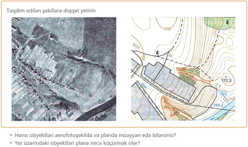
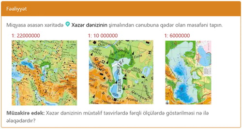
Figure 2. Exercise asking 7th grade pupils to measure the length of Caspian Sea from North to South on maps at different scales and discuss the reasons of the differences in the results (Qəribov et al., Citation2014).
A chapter, namely ‘Maps and its representation types’ in the Geography 8 textbook, is dedicated to those map concepts that highlights map types such as choropleth, isoline and dot maps; including also hachures, pie charts, map symbology and usage fields, distance calculations on maps and modern map data acquisition methods (GIS) (Eminov, Səmədov, & Əliyeva, Citation2015).
Map-like representations, topographic map-reading skills, almost all types of thematic maps including flow maps, map sketches, contour lines and population pyramids are included in the Geography textbook for 9th grade (Əlizadə, Seyfullayeva, Aktoprak, & Şabanova, Citation2016).
Besides textbooks, a combined school atlas and separate workbooks for 6th to 11th grades are available for better understanding of map concepts in the national curriculum. An interesting characteristic of this atlas is that sections are not separated by grades, which gives an opportunity to the educators in order to use the content of the atlas according to any matching concept on textbooks. However, the combined atlas is designed for a long-term use, which prevents to keep it up to date and physically is heavy to carry by the pupils. A new curriculum system was implemented in Azerbaijan since 2006 and separated atlases are expected to be produced within upcoming years.
2.2. Hungary
The Hungarian pupils acquire the first knowledge related to specific map concepts in 3rd grade, when they begin to learn themes as main characteristics and differences between settlements (farm, village, town, city, metropolis), elemental shapes of the relief (plain, hill and mountain), basic orientation (main cardinal points, Sun- and stars-based orientation, compass) as well as a basic definition of map and main types of maps in the Environmental Studies subject (Buzási, Néder, & Tóthné Mess, Citation2017).
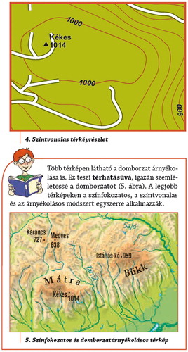
This subject is also taught in the 4th and 5th grades. In 4th grade pupils learn few new concepts related to maps, making emphasis on the more detailed study of different landforms and transport networks apart from other geographic topics. Grade 5 is a key year for the learning of basic cartographic concepts, when a chapter of the text – and workbook is exclusively dedicated to this topic. In the Environmental studies 5 textbook (Kropog, Láng, Mándics, Molnár, & Ütőné Visi, Citation2016a) the chapter dedicated to map concepts has 15 pages and it is divided into 6 subchapters: The map, Symbology on maps (I and II), Measurements on a map, Orientation with a compass and a map (I and II). Pupils can meet numerous new concepts related to the use of symbols on a Hungarian topographic map for excursionists, the definitions of altitude, height points, hypsometry, contour lines, shading as well as types of maps (physical, political, thematic and outline map) among other themes ().
Figure 3. Illustrations explaining methods for the representation of relief in a Hungarian textbook for 5th grade (Kropog et al., Citation2016a).
An interesting detail is that two appendixes complete the chapter: the first one is entitled ‘Hungarian Excellences’, presenting two famous Hungarian mapmakers (Lazarus secretary and Samuel Mikoviny), while the second (Useful websites) presents a Hungarian website on geocaching. On the final page of this chapter, pupils can find a diagram resuming the components of a map.
In grade 6 the subject is renamed to Studies on Nature (Természetismeret). The knowledge acquired in 5th grade is completed with the teaching of basic concepts on geographic coordinate systems: latitude, longitude, parallels, meridians as well as their use on maps (Kropog, Láng, Mándics, Molnár, & Ütőné Visi, Citation2016b).
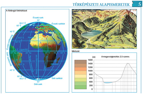
In 5th and 6th grades, pupils began to use more intensively the ‘School Atlas for elementary pupils’ in their classes. The first six pages of the atlas include the graphic presentation of basic cartographic concepts as shapes of relief (landforms) and their representation on maps, scale and geographic coordinate system () (Földrajzi Atlasz, Citation2017).
Figure 4. Teaching geographic coordinate system and cross-section in a Hungarian school atlas (Földrajzi Atlasz, Citation2017)
The Geography subject is taught in the last two grades of Elementary Schools in Hungary. Grade 7 can be characterized with the more intensive use of diverse thematic maps to complete texts and statistics. Pupils can find detailed explanations and exercises on how to use correctly the school atlas, as well as making emphasis on the use of climatic diagrams, population pyramids, cartograms and the reading of maps made for the weather forecast. Exercises included in the workbook uses also different types of thematic maps (vegetation, temperature, precipitation, population, etc), giving teachers the opportunity to explain how to read and analyse the data represented on those maps (Alexa, Gruber, Szöllősy, & Ütőné Visi, Citation2017). In 8th grade, the use of physical, political and thematic maps to illustrate or complete the text becomes more systematic and it is complemented with the more frequent use of different types of charts.
The teaching of basic map concepts is completed with new and more detailed knowledge in the first year (9th grade) of Secondary School. Pupils have the opportunity to learn topics related to computer maps, GIS, GPS and the use of internet-based mapping services as Google Maps and Google Earth (Arday et al., Citation2018).
2.3. United Arab Emirates
The Emirati pupils start studying geographical concepts at Kindergarten (KG) stage (KG1 and KG2). Some of these geographical concepts focus on the map concepts in a very basic and limited level. However, it is obvious that pupils in the UAE acquire the first knowledge related to specific map concepts in 1st grade, when they begin to learn the main places surrounding their houses (school, supermarket, clinic, etc.). Through basic orientation (cardinal points – North, South, East, West) they are able to identify the basic map elements (title, north arrow, and map key or legend), as well as the basic landforms (plain, hill, oasis, mountain, and desert). In addition, all the curriculum’s subjects included different types of exercises located after each lesson, to assess pupils’ knowledge skills and enhance their level of learning (Ministry of Education, Citation2017–Citation18).
The concepts learnt in the Social Studies subject in 1st grade are also taught in the 2nd, 3th and 4th grades but on a wider scale and higher level than in 1st grade. In grades 2, 3, and 4 pupils learn a multiplicity of new concepts related to cartography and map skills. In grade 2 pupils recognize the concept of geographical location, identify maps, read different geographical phenomena reflected with different geographical data, recognize the location of their city and other geographical phenomena (gulf, sea, plain, etc.). In grade 3 pupils are able to identify different landforms and describe them (oceans, mountains, valley, plain, hills, oasis). They can discover Sun- and stars-based orientation, day, night, four seasons, thermal areas and learn to identify more map elements. Furthermore, they are able to explain how the geographical location is impacted by climate and natural vegetation. Grade 4 curriculum promotes map concepts, including advanced map skills that help the pupils to read a thematic map. It also helps them to analyze the geographical data displayed on the lessons’ maps. All the exercises included in grades 2, 3, and 4 are appropriate to the specific topics and the level of the curriculum.
The Elementary School stage in UAE includes grades 1, 2, 3 and 4. Apparently, pupils acquired the most basic map concepts during grade 4, in comparison with the three previous grades. In addition, these map concepts became more detailed in the Secondary School stage (grades 5, 6, 7, and 8), and in High School stage (9, 10, 11, and 12), because these basic cartographic concepts are linked with the content of the textbook’s lessons and exercises as well as workbook activities. The Social Studies textbook for each stage (from KG1 to grade 12) are divided in three parts, which are taught during the three semesters of the school year. The map concepts enclosed in the Geography sections could be described in the lower stages in a simplified manner, but they are developed and given with more depth in the higher stages. Moreover, the map concepts are integrated with the rest of the subjects in the Social Studies textbook such as History, Economy, and National Education (Ministry of Education, Citation2017–Citation18).
In Secondary and High School textbooks pupils can find extensive, detailed exercises together with workbook activities that enable them to read and analyse the data represented on maps, and at the same time they use critical thinking in answering the questions related to the maps (Ministry of Education, Citation2017–Citation18).
Although the use of school atlases in UAE schools is considered as one of the most effective educational assistant sources to enable the pupils to understand the basic cartographic concepts, it is not frequently used by some teachers. The reason can be that there are not school atlases edited and published in the country, however, foreign school atlases can be used in the schools.
3. Considerations on the methods or solutions used to teach concepts
Azerbaijani teachers consider that in order to obtain well-structured knowledge, a precisely connected subject system is required. The integration of subjects has been considered after the establishment of the national curriculum system in 2006. Each subject textbook is provided with a methodical book for teachers which clearly indicates textbooks’ topics and their connectivity with the all other subject materials.
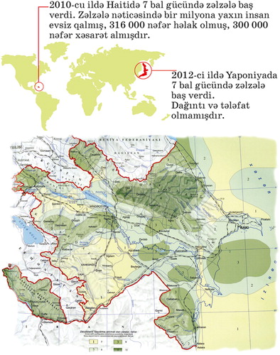
For instance, the ‘Earthquake – a natural process’ chapter in the Geography textbook for 6th grade explains the terms related to earthquakes and conditions for their occurrence (Əlizadə et al., Citation2013). At the same time, Life Knowledge textbook for 6th grade demonstrates how to be protected from a possible earthquake within the chapter entitled ‘Protection from hazardous cases’ (Məmmədova & Mahmudova, Citation2017). The first part of shows the earthquakes with magnitude 7 and their effects in Haiti and Japan, as they are included in chapter 18 of the Geography textbook for 6th grade. In this chapter, pupils are also asked to explain what can cause the huge differences of damages and losses between these two countries. The second part of the figure shows a map included in chapter 21 of the Life Knowledge textbook for 6th grade. It shows those regions in Azerbaijan where earthquakes can occur and explains pupils how to protect themselves during an earthquake. It is only one example of how to build a strong connection between subjects and to arouse the interest of pupils to the less attractive subjects, which is an important aim in the Azerbaijani Education System (Seyfullayeva, Şabanova, & Rakçeyeva, Citation2013).
Figure 5. Above: Earthquakes in Haiti and Japan (Əlizadə et al., 2013). Below: Regions exposed to earthquakes in Azerbaijan (Məmmədova & Mahmudova, Citation2017), as showed in the textbooks.
In Hungary, the teaching of basic map concepts is mainly developed in subjects related to the teaching of Geography. However, the teaching of these concepts can be also characterized by their inter- and multidisciplinarity. It means that pupils learn the concepts in subjects related to Geography, but at the same time they find the application or use of these concepts in other branches of knowledge as mathematics or grammar. In other words, pupils can discover the interaction between the content of different subjects, in the same way that those topics are related each to other in the real life. Two examples:
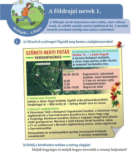
Hungarian pupils began to learn basic map concepts in 3rd grade. Almost a year later, in grade 4 they learn the correct use of geographic names in the subject entitled ‘Hungarian language and communication 4’ (Benkőné Nyirő, Jegesi, & Nanszák, Citation2016). In the four pages dedicated to this topic, pupils can find exercises illustrated with maps, which ask them to use the school atlas and seek after names of countries, provinces, rivers and mountains (). A glossary containing the geographic names used during the 4th grade was also included in the last pages of the textbook.
Pupils have also the opportunity to complete the learning of basic map concepts during the teaching of Mathematics in grade 5. In their Mathematics 5 textbook pupils can find themes as the role of positioning in our environment, measurements, units and statistics (data collection, use of tables and bar charts), including exercises with simple maps (Gedeon, Korom, Számadó, Tóthné Szalontai, & Wintsche, Citation2016). The mentioned themes let pupils deepen the knowledge to be used when they read the information represented on the maps.
Figure 6. Initial page of the chapter dedicated to geographic names in the textbook for 4th grade, asking pupils to answer questions about the places of an imaginary mountain race (Benkőné Nyirő et al., Citation2016).
Hungarian pupils should also make use of their knowledge on maps and especially in thematic map use during the History lessons between grades 5 and 8 in Elementary Schools. Not only the textbooks are profusely illustrated with maps, but they can also use the historical school atlases to complete the content of the text- and workbooks.
However, the successful interdisciplinarity and multidisciplinarity based on the map depends on an important factor: Hungarian teachers should be able to interact between them and exchange their ideas and experiences in the interest of improving their teaching activities for the pupils.
In the aftermath of integrating the Geography subject under the Social Studies subject in the United Arab Emirates (UAE), the pupils also find different maps in the chapters related to History, Economy, and National Education. Therefore, these maps help in understanding the lesson’s content in a very clear way. Explicitly, maps offer many benefits in teaching other themes. It summarizes rich information in a small space using colors, and helps to create an optical image to distribute information geographically and connect it to related sites, used to display spatial or temporal relationships. It also helps to explain the geographical phenomena of the place (Ryan, Citation1995).
The following example shows how pupils use the basic map concepts throughout different grades:
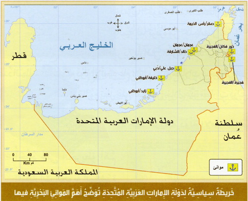
In subchapter 2.3 was mentioned that one of the basic map concepts that Emirati pupils learn in Grade 2 is to recognize the concept of the geographical location in a very simple level. Consequently, this concept is developed in an effective manner year after year. The pupils are able to apply this concept to one of the lessons in Grade 5 as can be seen in , which shows the map of the main sea ports in UAE. This map is part of an exercise asking the pupils to write the name of the sea ports located in the Eastern and Western directions. Furthermore, pupils are also asked to calculate the economic return of the large number of seaports in the country. It is followed by the next questions: use different sources to search for different goods that are imported and exported through these marine ports and make a proposal to contribute to the promotion of maritime transport between the UAE and the countries of the world in the field of tourism (Ministry of Education, Citation2017).
Figure 7. UAE map representing the main sea ports from the Social Studies textbook for grade 5 (Ministry of Education, Citation2017).
It is clear from the above examples that Emirati pupils are aware of the importance of using the map concepts in the practice, during the analysis of different exercises related to the different subjects in the text- and workbooks. Therefore, acquainting students with maps’ concepts since the early stages has a great role in refining their cartographic, more specifically their map skills and critical thinking to solve various geographical problems.
4. Interesting experiences
In Azerbaijan, several types of traditional exercises related with map concepts can be found in the education system:
Geographic object finding: it is one of the most common exercises in either textbooks or workbooks containing map concepts in Azerbaijan, starting from 6th grade. The exercise asks to find one or more geographical features on atlases or wall maps, which are mentioned by name or showed by its shape in the textbooks.
Coloring sketch maps: these maps are designed to be used next to 6–11th grades atlas and they are one of the most effective ways of map teaching concepts in Azerbaijan curriculum system. The idea behind sketch maps is to apply studied geographical knowledge (such as map symbols, administrative borders, climate zones, etc.) to a map. The exercise strikes pupils to understand the conscious usage of the map elements. However, it could be better to move the sketch map exercises to Elementary School workbooks, because junior pupils would enjoy more this activity as a fun way of learning maps.
Neighborhood plan making: the exercise is a part of 6th and 7th grades practice lessons and can also be organized as homework according to the theme of a lesson. By making a plan of familiar places such as home, school, etc., pupils understand the logic of generalization in practice.
Linear profile drawing: the exercise is generally given to pupils starting from 7th grade to provide a better understanding of depth and altitude representations on maps. It is required to draw a given line profile of a physical geographical map including the names of those geographical features crossed by the line.
Mathematical calculations: calculation based exercises on maps are used to support pupils’ learning process of coordinates, time zones, etc. between grades 6 and 11. To this end, a set of points is given on a map to be found out its position from a predefined geographical object. The complexity level of the exercise is changing up to grades and mathematical knowledge of pupils ().
Figure 8. Exercise asking 6th grade pupils to calculate the distance between two points considering the scale (Əlizadə et al., 2013).
Taking everything into account, although exercises used in map teaching concepts in Azerbaijan can be considered well-designed and effective, they are lacking from the integration with the modern technology, which is crucial for improving pupils’ real-time orientation skills. Including internet-based programs (Google Maps, Google Earth) related exercises to the curriculum can help pupils to become acquainted with the modern world easily.
In the Hungarian Education System, pupils finish the learning of basic map concepts in 6th grade. In grades 7 and 8 they are going to use the acquired knowledge and skills during the study of Geography of Hungary, Europe and other continents. However, beginning the Geography textbook for 7th grade pupils can find an introduction dedicated to give orientations for improving the map use not only in the classroom, but in their daily life too. The list of themes included in this introduction is as follows:
‘How to find where is? Knacks of using maps’: Focusing on how to use the school atlas correctly, presenting explanations and exercises on the use of the glossary, index grid and geographic coordinate system (three pages)
‘Click on Earth! The use of Google Earth’: how to use different options offered by Google Earth, e.g. planning and using a route (four pages)
‘Not only learn, but think! (Understanding geographic information)’: Exercises and explanations for the correct use of climatic diagrams, analysis of weather forecast with a map showing temperatures in Hungary and exercises related to population data, using population pyramids and cartograms (four pages)
In this same textbook for 7th grade, we can also find exercises using not only Google Earth, but Google Maps too. These activities can be considered a preliminary practice, because pupils will find more exercises asking them to use these map services in the Geography text- and workbooks written for the Secondary School.
Other remarkable experience is the interest for improving the diversity of graphic representations used during the teaching activities. Diversity is not only characterized by the different types of graphic representations designed to complete or illustrate the text (images, charts, maps, photos, etc.), but also by the variety of solutions that can be found within a specific type of representation. It means that pupils have the opportunity to use different types of charts (column, line, pie, etc.) representing different themes (e.g. climatic or temperature), to read data from different types of thematic maps (population, meteorological, geological, vegetation, etc.) as well as map-derived representations (cross-sections, cartograms). In this way, pupils can practice how to use, read and understand them, widening pupils’ capacity to assimilate more complex graphic solutions in the future.
In the Emirati Educational System, pupils finish the learning of basic map concepts in 4th grade in Elementary School stage, and in the Secondary and High School stages the pupils apply their map skills during the lessons of Social Studies. Besides the diversity of exercises and workbook activities that the pupils use, there are many exciting initiatives designed and highlighted to promote a wider range of modern geographical tools explained and used by teachers in the classroom (Al-Zubaidi & Al Hosani, Citation2016). Only some examples ():
Google Earth: It is used as an educational tool adapted for Geography lessons in secondary and high schools. It helps the pupils to visualize and understand the world around them.
Google Maps: It helps teachers and students to explore, create and collaborate using mapping tools.
Global Positioning System (GPS): It uses satellites to locate latitude and longitude and get directions, being a core component of mobile devices and applications related to Geography.
Geographic games: Pupils can find different websites specialized on creating games, one of them is Kahoot (https://create.kahoot.it), a game-based learning platform that utilizes modern technology and solutions to create educational games for schools (Aldarmaki & Al Hosani, Citation2017).
Figure 9. Page of the text book for 5th grade pupils explaining the use of new technologies (Ministry of Education, Citation2017).
Regardless of the preceding examples, there are some obstacles confronted by teachers and pupils to join these initiatives. These obstacles are related to the lack of specific educational resources, to the availability of the network, or to the supplies of computers or other equipment needed for using the above-mentioned resources. Al Hosani and Yagoub (Citation2015) suggested that schools have to provide continuous geographic – skills training to teachers, to be aware of the most up-to-date software and applications developed for improving the geographic skills.
5. Conclusions
Based on our study, we can affirm that the teaching activities in the three countries follow a similar model: the basic concepts are first explained in the textbooks. Pupils can also find questions and tasks in the textbooks, which are placed on the last pages of the chapter dedicated to this topic. The main aim of these questions is to deepen the concepts described briefly in the previous pages, asking pupils to use other (printed or digital) sources to answer them. In Hungary, the questions also ask children to consult the school atlases. Workbooks contain more practical questions, which focuse on strengthening the knowledge of the learnt concepts, showing the relations between them and their combined use in daily activities. Exercises in the workbooks also rely on the use of school (or other type of) atlases.
The following similarities and differences were found during the research:
Teaching of basic map concepts begins in early grades, when pupils can acquire basic knowledge related to orientation (e.g. cardinal points) and their immediate neighborhood and environment. United Arab Emirates (UAE) stand out for starting these activities in the first grade of elementary school.
Traditional exercises and teaching methods are prevalent in these three countries. Azerbaijani pupils can solve a varied spectrum of traditional exercises, but the current textbooks do not stimulate the use of newest technologies. In UAE and Hungary the presence of internet-based solutions (e.g. use of Google Earth and Google Maps) are gaining space in the text – and workbooks, however, they still constitute a small number of exercises. By this reason, we can affirm that today the use of new technologies (or computer-based education) has no relevant impact of changing the classroom experience in these countries and their influence is limited to a low number of schools.
The importance of the use of school atlases during the teaching activities is recognized in the three countries, first of all because the content of these atlases is based on the respective national curricula. Currently, UAE is not producing this type of atlases and in Azerbaijan, only one school atlas is used between grades 6 and 11. In Hungary, the use of these atlases can be considered a more traditional activity and they are not only limited to complete subjects related to Geography, but pupils can also find school atlases published for their use in other subjects.
Azerbaijani pupils have the opportunity to learn knowledge related to Geography in more detail and for a longer time, from 2nd to 11th grade. In Hungary, the current situation is similar (pupils can learn subjects related to Geography from 2nd to 10th grade), but the number of hours dedicated to this subject can decrease in the future, under the influence of the negative trends observed in the current European education. UAE added the geographic content to a more general subject entitled Social Studies, which is taught during all the grades of elementary, secondary and high schools. The integration of four subjects under the Social Studies facilitated that pupils can recognize better, in a more direct way how maps are used in different branches of knowledge.
Which current practices could be applied in the studied countries mutually? Authors can highlight two solutions that can be considered useful for the teaching of concepts related to maps and their practical use: The first one is the simultaneous use of school atlases in different subjects that apparently does not have a direct connection, as it was explained with the Hungarian examples mentioned in chapter 3. The second one is generally applied in the textbooks published in the three countries, namely the use of diverse graphic solutions (different types of maps, charts, combination of them, etc.) to illustrate the content of the textbooks. Authors consider it essential to develop and diversify pupils’ graphic skills in general, paying special attention to the correct diversification of maps used in the textbooks that may also include less common cartographic solutions such as cartograms.
After finishing this preliminary research, some questions remained open and waiting for answers. Only two examples to corroborate the previous affirmation:
There is a need of not only publishing printed school atlases based on national curricula, but of developing them with the advantages offered by the newest and widespread mobile technologies to create a more efficient, interactive tool. During our research, we visited two popular web stores (Google Play and Apple Store) and did not find any school atlas that would have been made specifically for mobile devices in any country.
Specialists from different countries have been developed research on how web-based map services (e.g. Google Maps and Google Earth) could be used in the teaching activities or to complete them. Barros de Sousa (Citation2014) wrote her MSc thesis on how Brazilian students from a neighborhood in Niterói (Brazil) used the map services to visualize the results of a socio-environmental survey developed by themselves. Kiss and Reyes Nunez (Citation2018) explained how Secondary level pupils used the Google My Maps application to create simple maps on selected themes related to the Geography of Water. Despite these and other studies, the use of the map services in teaching activities has not yet reached the level that could be expected if we consider its widespread use by the general public (and by the older pupils themselves) in daily life.
The authors consider the re-edition and publication of textbooks, workbooks and school atlases in mobile devices of vital importance, so that national education can take advantage of the interest of new generations towards new technologies, while improving and diversifying the options that teachers can offer in and outside of classrooms. This is a very complex topic, which needs of a wider and closer cooperation between researchers, possible publishers, representatives of education ministries and teachers. This and other tasks should continue to be studied in new research projects in the coming years.
Disclosure statement
No potential conflict of interest was reported by the authors.
Notes on contributors
Nargiz Safaraliyeva obtained her BSc in Geography at Baku State University (2015) and her MSc in Cartography (specialized on Remote Sensing) at Eötvös Lorand University (2018) in Budapest, Hungary. Her research crosscuts a range of areas in School Cartography, Tourist Cartography, Tourism Economy, Optical and Radar Remote Sensing. Nargiz is author of 10 articles published in international scientific conference proceedings. She provides administrative support to the SpecialDayDeal team since February 2019 in Azerbaijan. Currently, she continues working in her research interests as an individual researcher.
Dr. Naeema Alhosani obtained her M.A. (2005) and her Ph. D. degree (2009) on Geography (with specialization on Cartography) at the University of Kansas, USA. She was an assistant dean for student affairs in the College of Humanities & Social Sciences at United Arab Emirates University from 2013 to 2017 and Head of the Department of Geography & Urban Planning since August 2017. Her research interests are: Cartography, Maps & Mapping, Map Conception & Development, Cartographic Design, Information Design, Practicum in Cartography, Problems in Map Production, Environment, GIS, and Remote Sensing. Dr. Naeema has participated in many regional and international conferences, research projects and map publications, besides being a member of different professional committees in the United Arab Emirates, as well as she is affiliated to many professional associations. She has various scientific contributions at the departmental, College, University and Community levels.
José Jesús Reyes Nunez is Associate Professor at Eötvös Loránd University in Budapest, Hungary. His research interests lie in Cartography for Children (teaching of cartographic concepts and map use in Elementary and Secondary Schools), Digital and GIS Cartography, Web Cartography and Geovisualization. Author of more than 25 articles in scientific publications and more than 65 papers in different events, he has collaborated as cartographer in more than 40 textbooks and atlases. He is responsible for the organization of the Barbara Petchenik Map Competition in Hungary from 1999, being President of the International Jury in 2005 and 2007. He was Chair of the ICA Commission on Cartography and Children from 2007 to 2015, currently Vice-Chair of the same Commission. The International Cartographic Association awarded him with the Diploma for Outstandings Services to ICA in 2015.
ORCID
José Jesús Reyes Nunez http://orcid.org/0000-0001-6080-8667
References
- Aldarmaki, N., & Al Hosani, N. (2017). Teaching geography through games. National conference on geography, July 27-30. Alburquerque, USA.
- Alexa, P., Gruber, L., Szöllősy, L., & Ütőné Visi, J. (2017). Földrajz 7 tankönyv. Eszterházy Károly University and Hungarian Institute for Educational Research and Development. Eger, Hungary.
- Al Hosani, N., & Yagoub, M. M. (2015). Geographic skills: A case-study of students in United Arab Emirates, UAE. International Research in Geographical and Environmental Education, 24(1), 95–102. Taylor & Francis. London, UK. doi: 10.1080/10382046.2014.967513
- Əlizadə, E., Seyfullayeva, N., Aktoprak, İ, & Şabanova, Y. (2016). Coğrafiya 9. Bakınəşr. Baku, Azerbaijan.
- Əlizadə, E., Seyfullayeva, N., Rakçeyeva, İ, & Şabanova, Y. (2013). Coğrafiya 6. Bakınəşr. Baku, Azerbaijan.
- Al-Zubaidi, A., & Al Hosani, N. (2016). iPad apps for teaching geography. Annual Meeting of the North American Cartographic Information Society (NACIS), October 19-22. Colorado Springs, USA.
- Arday, I., Buránszkiné Sallai, M., Makádi, M., Nagy, B., Sáriné Gál, E., & Ütőné Visi, J. (2018). Földrajz 9 tankönyv. Eszterházy Károly University and Hungarian Institute for Educational Research and Development. Eger, Hungary.
- Barros de Sousa, I. (2014). Geotecnologias e Recursos de Multimídia no Ensino de Cartografia: Percepção Socioambiental do Rio Alcântara no Município de São Gonçalo/RJ. MSc thesis, Universidade do Estado do Rio de Janeiro, Brazil.
- Benkőné Nyirő, J., Jegesi, K., & Nanszák, A. (2016). Anyanyelv és kommunikáció 4. osztályosoknak tankönyv. Hungarian Institute for Educational Research and Development. Budapest, Hungary.
- Buzási, É., Néder K., & Tóthné Mess, E. (2017). Környezetismeret 3 tankönyv. Eszterházy Károly University and Hungarian Institute for Educational Research and Development. Eger, Hungary.
- Eminov, Z. N., Səmədov, Q. M., & Əliyeva, A. R. (2015). Coğrafiya 8. Xəzər Etiket. Baku, Azerbaijan.
- Földrajzi Atlasz általános iskolásoknak (2017). 1st revised edition. Eszterházy Károly University and Hungarian Institute for Educational Research and Development. Eger, Hungary.
- Gedeon, V., Korom, P. J., Számadó, L., Tóthné Szalontai, A., & Wintsche, G. (2016). Matematika 5. Hungarian Institute for Educational Research and Development. Budapest, Hungary.
- İbrahimova, A., Mehdiyeva, G., & İbrahimov, S. (2014). Həyat bilgisi 2. Aspoliqraf. Baku, Azerbaijan.
- Kiss, J., & Reyes Nunez, J. J. (2018). Uso de los servicios de mapas de la Web en la enseñanza secundaria. Convención y Feria Informática 2018: X Congreso Internacional de Geomática, March 19-23, Havana, Cuba.
- Klinghammer, I. (2002). A földrajzi szemléltetés korai története - Iskolai térképek, atlaszok, föld- és éggömbök az egykori magyar iskolákban. Geodézia és Kartográfia, 54(12), 1–13. Budapest, Hungary.
- Klinghammer, I., & Reyes Nunez, J. J. (2017). A brief retrospection on Hungarian school atlases. The Cartographic Journal, 54(4), 333–342. British Cartographic Society. London, United Kingdom. doi: 10.1080/00087041.2017.1400220
- Kropog, E., Láng, G., Mándics, D., Molnár, K., & Ütőné Visi, J. (2016a). Környezetismeret 5 tankönyv. 1st revised ed. Budapest: Hungarian Institute for Educational Research and Development.
- Kropog, E., Láng, G., Mándics, D., Molnár, K., & Ütőné Visi, J. (2016b). Természetismeret 6 tankönyv. Eger, Hungary: Eszterházy Károly University and Hungarian Institute for Educational Research and Development.
- Məmmədova, N., & Mahmudova, K. (2017). Həyat bilgisi 6. Şərq-Qərb. Baku, Azerbaijan.
- Məmmədova, N., Mahmudova, K., & Bağmanlı, A. (2016). Həyat bilgisi 5. Şərq-Qərb. Baku, Azerbaijan.
- Mehdiyeva, G., & Bayramova, F. (2014). Həyat bilgisi 3. Aspoliqraf. Baku, Azerbaijan.
- Mehdiyeva, G., & Kərimova, B. (2015). Həyat bilgisi 4. Aspoliqraf. Baku, Azerbaijan.
- Ministry of Education. (2017). Social Studies textbook for grade 5, part 2. Abu Dhabi, UAE.
- Ministry of Education. (2017–2018). Social Studies textbook for grades KG-12. Abu Dhabi, UAE.
- Qəribov, Y., Seyfullayeva, N. S., Hümbətova, Ş., Şabanova, Y., and İsmayılova, T. (2014). Coğrafiya 7. Bakınəşr. Baku, Azerbaijan.
- Ridge, N. (2011). The reality of education and the future prospects for its development in the United Arab Emirates. In Chapter III: The role of the curriculum in creating a built economy on knowledge in the UAE (pp. 79–112). Abu Dhabi: Emirates Center for Strategic Studies and Research.
- Ryan, F. H. (1995). Teaching: Objectives, foundations, methods, evaluation of results, and applications (3rd ed.). Cairo: Book World.
- Seyfullayeva, N. S. (2017). Coğrfiya Tədrisinin İnkişaf Tarixi. Bakınəşr. Baku, Azerbaijan.
- Seyfullayeva, N., Şabanova, Y., & Rakçeyeva, İ. (2013). Coğrafiya– 6. Müəllim üçün metodik vəsait. Bakınəşr. Baku, Azerbaijan.