
ABSTRACT
In a one-year long experiment, the City of Frankfurt has limited the vehicular access to an 800 m stretch of its Mainkai riverfront as part of its plans to improve quality of life and support green mobility. With pre-intervention data collected in July 2019, this article presents the first results on how pedestrians, cyclists and other user-groups have been using this open public space in May 2020, i.e. post road closure and during the coronavirus restrictions. Based on pedestrian counts and behavioural observations, the authors report on a changed pedestrian mobility, spatial distribution and different stationary activities such as playing, sitting and socializing. The results show an increased peak hour frequency among cyclists (+45%) and pedestrians (+20%) on Mainkai street, along with more vulnerable user groups including including children cycling independently (+1150%) and people with restricted mobility (+25%). The study underlines related initiatives world-wide that pedestrianization acts as a catalyst for safer and healthier urban environments. Particularly, under the impression of an ongoing coronavirus pandemic, the study suggests that (temporary) road closure to cars is a key element in qualifying public space that attracts different user-groups and caters to an increased need to become physically active and engage socially while keeping distancing rules.
Introduction
Streets comprise more than 80% of public space in cities, but they often fail to provide their surrounding communities with a space where people can safely walk, bicycle, drive, take transit, and socialize (NACTO Citation2013). There have been recurring scenarios with urban streets being pedestrianized and restructured to suit the influx of pedestrians, bicyclists and other active users, indicating a paradigm shift where people-centric planning approach is gaining importance over automotive-centric approach. In many cities, good public conditions are a quality feature and a prerequisite for a high quality of life. Many cities are beginning to shift their mobility solutions away from the private cars and towards more environmentally friendly and citizen-focused mobility means (Nieuwenhuijsen and Khreis Citation2016).
Globally, with the increase of passive modes of transportation, insufficient levels of physical activities have been observed. This includes 81% of adolescents being insufficiently physically active, with major environmental factors such as high-density traffic, lack of recreational facilities, air quality, and outdoor safety (WHO Citation2018). In the past, there have been several measures taken into consideration to tackle these factors, with ‘traffic calming’ (translated from German word ‘verkehrsberuhigung’ (Hass-Klau Citation1989)) being one of them. It is established on the idea of streets to offer and preserve a sense of place for people to carry out different activities, even alongside car traffic without the later dominating (PPS Citation2008) through reduced passability and accessibility of cars via legislation, marking, visual or physical effects (Kjemtrup and Herrstedt Citation1992).
The onset of the traffic-calming practice dates back to mid 20th century, when private car ownership and its use on road increased exponentially, leading to constant road congestion in cities especially in Europe. The design coined as ‘Woonerf design’ was the first traffic-calming initiative, which took eight years to be officially legalized in Netherlands. Other countries followed the implementation through experimental studies, including Germany and Sweden (Kjemtrup and Herrstedt Citation1992). In Denmark, the Road Traffic Act of 1976 established roads with priority given to pedestrians (Larsen et al. Citation1978). To reduce high traffic flow in London, the authorities initiated ‘congestion charges’ in 2003 to reduce high traffic density on urban streets, encouraging more trips by walking and cycling. In immediate years, the initiative leads to substantial drop in traffic congestion calming (Leape Citation2006). Over the years, traffic-calming and road closure initiatives have played a significant role in enhancing road safety of urban areas (Juhász and Koren Citation2016). The article addresses the impact of road closure experiment on the public space usage by people, especially during the coronavirus (COVID-19) pandemic, making it a rare opportunity to study its influence through multiple perspectives.
State of the art
Mobility management measures have been increasing in the last years attempting to change the travel behaviour of the population towards a more sustainable one. The famous push and pull factors (restricting and encouraging factors) or the ‘soft and hard measures’ (Clarke Citation2012) (Gärling et al. Citation2009) are nowadays being used by planners worldwide focusing on a smaller scale (i.e. street scale), low risk, low cost, less impact, temporary or transitional, experimental, flexible, and bottom-up measures (Papagiannakis and Vitopoulou Citation2015). They aim for low-cost and short-term actions for a long-term change in the city. Most of these contemporary approaches and strategies are placed on the street as it is one of the most important public spaces in an urban area. Nevertheless, the street has changed to be seen as one-function-space (transportation) to a multifunctional space (März et al. Citation2020), with social, ecological and economic functions. The street as a space has to be re-designed to be resilient and sustainable. A ‘temporary street closure restricts a street to pedestrians, and in some cases bicyclists, rollerbladers, and skateboarders at specific times of day, specific days of the week or during the year, or for certain seasons’ (Sadik-Khan Citation2013). Temporary street closures, car-free street, open streets, or play-streets are some synonyms for traffic-calming strategies leading to pedestrianizing a street. Pedestrianization of the congested street is a very effective, low-cost and sustainable solution with numerous benefits rather than only reducing car congestion (Soni and Soni Citation2016) (Nieuwenhuijsen and Khreis Citation2016). The aim of this chapter is to introduce the impacts of pedestrianizing a street which can be divided into six categories according to the available literature: pedestrian behaviour and density, stationary activities, environment-related, economy-related, transportation-related and social development.
Pedestrian behaviour and density
Open spaces are ideal opportunities to be active and have proven to provide various health benefits to citizens. They may act as determinants of health and support the promotion of a health-related behaviour of city dwellers (Halblaub Miranda et al. Citation2019). There is a strong and vast documented relationship between physical activity, particularly for walking, and the built environment (i.e. improved walking infrastructure, which accounts for pedestrianizing streets). Montgomery (Citation2013) states that pedestrianization increases the number of trips on foot and therefore enhances other activities including social interaction. Karndacharuk et al. (Citation2013) show in a study, conducted in New Zealand in three different shared street areas, how indirectly pedestrian density relates to car traffic speed. In other words, low car traffic speed in an area reflects higher pedestrian density.
As an example for this, Wolf et al. (Citation2015) studied the impact of a temporary recurrent street closure ‘the Summer Streets’ on physical activity in the city of New York, where the participants engaged in the equivalent of 72–86 minutes of moderate-level physical activity (mostly by walking), about half of the total minutes of weekly physical activity recommended. The event also mobilized many New Yorkers who do not usually get enough physical activity, engaging in the equivalent of 26–68 minutes of moderate-level physical activity. Additionally, 87% of all participants used an active mode of transportation to the event, increasing their accumulated physical activity minutes. Research conducted in East Belfast, United Kingdom, proved that urban renewal programs, improvement in walking infrastructure and people´s perception of access to shops and facilities can improve the health of inactive residents. Improving walkability has shown to increase walking on average by 36 min/person/week. Through walkability upgrades, guidelines for physical activity were met by 12.8% of the population who had been previously inactive (Longo et al. Citation2015).
With respect to the pedestrian behaviour on children, most of the interventions planned for this socio-demographic group are named as ‘play streets’, which is usually a road closure, with an objective of increasing usage of public spaces by children (through playing, walking, cycling, etc.). On this frame, Umstattd Meyer et al. (Citation2019) conducted a systematic review of how ‘play streets’ impact opportunities for active play, physical activity, which accounts for walking and cycling, neighbours and communities. The report concludes that play streets can create safe places for children to actively play, and move with promise of increasing physical activity and strengthening community. Another study related to play streets conducted in Santiago, Chile in 2014 (Cortinez-O’Ryan et al. Citation2017) measured physical activity using pedometers in a pre-post-test quasi-experimental study. Play streets were held two times per week for twelve consecutive weeks; as a result, the participants who played 3 hours during the play street intervention had significantly more steps after the final assessment compared to the no-play street participants, who experienced no differences in steps. The play street was successful as well in increasing the number of children meeting the physical activity recommendations from baseline to the post-test.
Stationary activities
Since the 1960s, researchers and journalists have been critical about the car invasion in public spaces. The priority for cars in the design of public spaces has led to fewer activities (stationary and mobile) for people. While some authors recommend finding a new concept for urban spaces which enhances a balance between mobile activities (walking, cycling, moving in motorised transport) and stationary activities (social interaction, cultural expressions) when designing urban streets (Nikolaeva Citation2012), others remain conscious about the existing tension linking these two activities in one space (von Schönfeld & Bertolini, Citation2017). Pedestrianizing a street can be a key strategy to merge these two types of activities, leaving aside the motorised traffic in a massive way.
In order to illustrate the potential of traffic calming on the increasing stationary activities, Karndacharuk et al. (Citation2013) show that pedestrian occupancy (or stationary activities) in a normal street in New Zealand increased by 10% after converting it into a shared street. The study also indicated increase in the social activity of chatting from 29% to 47% along with more diverse activities. Moreover, studies done by Gehl and Svarre (Citation2013) mostly in Copenhagen support the theory that more space for people leads to more stationary activities performed in a public space.
Environment
The most researched impact of pedestrianization on the environment is the air and noise pollution. There are several studies reporting improvements in the air and noise quality after banning car traffic in some areas. Some studies focus on a long-term pedestrianization strategy (European Commission Citation2004), which shows more accurate and reliable results than the studies focusing on a single day (Willsher Citation2015) (Brussels Environment Citation2020).
Transportation
It is often argued that the main impact of a road closure will be an increase in traffic in other areas (and with this air and noise pollution). Nevertheless, the theory of ‘traffic evaporation’ stands for the opposite: reducing road capacity for cars in congested areas in the city and at the same time showing no increase (or even decrease) of motorized traffic with the time (European Commission. Environment Directorate-General Citation2004). This theory is supported by Cairns et al. (Citation2002) who examine 70 case studies of road space reallocation from eleven countries, and the collation of opinions from over 200 transport professionals worldwide. The findings suggest that ‘well-designed and well-implemented schemes to reallocate roadspace away from general traffic can help to improve conditions for pedestrians, cyclists or public transport users, without significantly increasing congestion or other related problems’ (Cairns et al. Citation2002). Moreover, after reducing road capacity as a strategy in a city, reductions in traffic level can occur due to a change in people´s mobility behaviour (i.e. change in the journey route, different means of travel, time of travel, change on destinations, etc.).
Economy
According to Leinberger and Alfonso (Citation2012) and Litman (Citation2011), pedestrian-friendly areas have an effect on economic value, stimulating the economic transactions due to the higher pedestrian flow. Another positive effect of pedestrianization is an increase in the property value (Sandahl and Lindh Citation1995, Diao and Ferreira Citation2010, Gilderbloom et al. Citation2015).
Social development
A study by Mason et al. (Citation2011), focusing on the impacts of the ‘Open Streets’ (a temporary car-free street) in Chicago during 2008 and 2009 through five different communities, found Open Streets events to be successful in promoting inter-community organizational partnerships, community organizing and resident interaction; all contributors to increased community capacity for engaging in successful health promotion activities.
Temporary interventions and studies during coronavirus pandemic in Europe
The pandemic has changed mobility behaviour with an increasing number of cyclists and pedestrians observed in most of the European cities during COVID-19 pandemic. In the middle of May 2020, London launched the ‘Streetspace program’ in order to transform streets to adapt to tenfold cyclists and fivefold pedestrians (TFL Citation2020). In Italy, Milan allowed bars and restaurants to expand their outdoor space at no cost, and plans to convert 35 kms of street network into cycling and walking lanes in order to give more priority to cyclists and pedestrians. The measures include establishing new temporary cycling lanes, wide sidewalk area, and lower traffic speed (The Guardian Citation2020). In France, Paris allowed shops to expand their premises into street parking lots, and in addition to this, plans to create 650 kms of cycling lanes to transform its biggest cross-city through route into a bicycle-only highway (Forbes Citation2020). These measures not only meet temporary needs, but also push city’s ongoing shift from car-oriented to human-oriented planning.
Life in public space has been reshaping during the pandemic period. In order to understand how streets and public spaces serve the very unique needs of the society during the pandemic, Gehl (Citation2020) investigated the public life in four cities of Denmark before and during COVID-19. The study included similar seasonal timeline with data from three different years (with datasets having a minimum gap interval of 14 months). The study showed decrease in downtown activities, especially on commercial streets, with an increase in pedestrian movement outside the city center. With respect to the usage of public space, it remained constant, although the pedestrian flow decreased. Local places became more popular during COVID-19, making social distancing policy hard to implement. Spaces with natural elements and pleasant climate were still the primary destination for people. Within these cities, new forms of activities were emerging with people adjusting themselves to the places for their exercise goals, with more children and old people using the city’s space than before.
Frankfurt am Main and the Mainkai riverfront road closure experiment
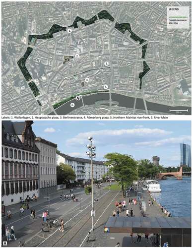
Frankfurt am Main is located in the centre of Germany, being its fifth largest city by population with an estimated 777,156 citizens in 2020, which is expected to cross 800,000 in next four years (UN Citation2018). From medieval times, the city of Frankfurt has evolved geographically in a series of rings. These included the Zeil Ring, the Anlage ring and the Ringstrasse, designed during Adicke’s administration. Within these rings no large plots of open land were available and industries were concentrated along the edge of the river Main in the eastern and the western sectors of the city during the early 1900s (Mullin Citation1977). Today some of the industries still exist along the river, along with residential and commercial landuse. The northern Mainkai riverfront still includes a railtrack, which runs through different green open spaces in east-west direction, for transport of industrial goods.
Figure 1. Immediate areas in close vicinity to Mainkai; A: Overlooking Mainkai street and riverside pathway from pedestrian bridge i.e. Eiserner Steg (post road closure)
Initiative from the city of Frankfurt
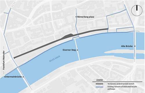
Based on previous urban studies in Germany, majority of the citizens believe to have a better life if there is less car dependency, and favour urban development practices that focus on an alternative as compared to car-centric approach for their city or community (BMU Citation2017). Progressing towards a people-centric planning, the planning department of Frankfurt developed Innenstadt-Konzept (i.e. inner city concept) (Frankfurt Stadtplanungsamt Citation2014), which focuses on reducing the present share of dense vehicular traffic on the streets of Berlinerstrasse and Mainkai (), as one of its measures. An overall aim is to link the pedestrianized zone of city centre to the Mainkai riverfront via Römerberg plaza in a more pedestrian-friendly manner. The temporary closure of northern Mainkai street has been implemented for a year, starting from August 2019. The pedestrianized stretch () between Untermainbrücke and Alte Brücke (the oldest bridge through the lower course of the river) has brought the ongoing vehicular traffic to a halt and encourages pedestrians to use the space. Eiserner Steg is the third bridge adjacent to the Mainkai street, open only to pedestrians connecting southern riverfront (which is not pedestrianized). The stretch has multiple user profiles dominating daily with different age groups being mobile ranging from bicyclists, users with reduced mobility (e.g. wheelchair users) to electronic scooter (e-scooter) users. The dynamic range consisting of both slow-paced and fast-paced users utilize the pedestrian pathway on the riverside (prior to road closure) next to the high-density traffic roadway, and with the traffic-calming measure put in place, would propel a more active usage of an open space.
Public and political perception
The temporary experiment has been controversially discussed among policy makers from very early stages. As a result, the coalition between left-centered, right-centered and green party agreed to temporarily close the Mainkai street, but decided not to complement the road closure with any design interventions (such as placemaking, urban gardening, etc.), being careful that the experiment would not leave any irreversible traces, e.g. no holes in the asphalt from additional street furniture. This is an unusual approach as many other traffic experiments aim to balance restrictive (push) measurements, such as banning cars, parking management with (pull) measures such as placemaking, to showcase an added value in terms of amenity qualities, pedestrian accessibility and urban qualities known as tactical urbanism (Lydon and Garcia Citation2015).
Figure 2. Pedestrianized Mainkai street on the northern Main riverfront in Frankfurt
Since its start the experiment has also received a mixed perception in public: On the one hand, citizens and policy makers consider the experiment a success, highlighting the new potentials of appropriating the spaces, on the other hand, it is considered a failure, pointing towards higher volume of car traffic in the neighboring streets and the lack of participation, long-term vision and opportunities to use the new space. The road closure of northern Mainkai riverfront has led to increase in the traffic density on southern riverfront (Frankfurter Neue Presse Citation2019), in turn affecting the social events (including weekly flea market in the southern part of the river). With local elections coming up in spring 2021, the future of the experiment remains unclear.
Research questions
The experimental closure along the riverfront in Frankfurt, which is situated at the heart of the city centre, presents a rare opportunity to analyze the immediate public space with and without car traffic during the pandemic period, via multiple perspectives, answering following research questions:
1. Has pedestrian density increased during COVID-19/road closure? Is there a change in the distribution of where people choose to walk and cycle? Is there a change in who is using the public space, e.g. an increased participation of children and vulnerable people?
Especially with the research study being conducted during the COVID-19 pandemic scenario, the effect of social distancing will play a role in understanding the spatial distribution of people in public space. The road closure experiment should provide opportunities for added physical activities among children, which are rare in urban areas (World Health Organization Citation2018). With previous studies in Germany resulting in people favoring car-free urban planning and looking for alternative planning approach (BMU Citation2017), the authors assume that the road closure experiment should culminate in higher pedestrian counts in a normal (non-pandemic) scenario. On the other hand, the authors are aware that this effect might be countered by social distancing measures and home office conditions due to COVID-19 which leads to overall decreased mobile activities including active travel.
With respect to children’s behaviour in public spaces, research shows that traffic infrastructure has a significant impact on parental decision making concerning children’s travel mode choice, by affecting both the real and the perceived traffic safety (Nevelsteen et al. Citation2011). Therefore, it is assumed that with the pedestrianization strategy implemented at the Mainkai Street, more children are going to walk and cycle along this stretch.
2. How do people use Mainkai public space after road closure during pandemic? Is there a change in the amount and kind of stationary activities? Are there any new forms of activities emerging on Mainkai?
Regarding stationary behaviour of pedestrians, traffic noise has shown its negative influence; where high noise levels have led to pedestrians paying less attention to their surroundings, in turn making them walk faster (Korte and Grant Citation1980). Since the road closure has made Mainkai a car-free street, there should be a change in the public behaviour. With the lockdown policies being gradually lifted, i.e. less restriction on amount of people allowed in a group (people from more than one household being allowed to stay in public during May 2020), with restaurants and shops reopening, more pedestrians are observed in public spaces. In Gehl’s report during the COVID-19 pandemic, the city was being used more for recreational and exercise purposes with new emerging activities. Under the road closure and pandemic conditions in May 2020, the authors assume more people to perform new and diverse stationary activities in Mainkai.
Methodology
The pedestrianized Mainkai riverfront covers approximately 800 m in length with range of open green spaces, children’s park, adjoining streets and bridges, with a non-frequent rail track running in east-west direction. The diversity of spaces was taken into consideration to showcase different perspectives which involves observing active mobility in a shared space, identifying active spaces for children and families, and observing stationary activities. The research takes into consideration two sets of data collected before and after road closure. The data before the road closure were collected during the month of July in 2019, weeks prior to any pedestrianization strategy affected the normal flow of the people using the space.
A period of time was required for the people to realize and get accustomed to the extended open space and have a natural way of movement, which forced the post-scenario data to be collected in later stages of the traffic calming. During the COVID-19 pandemic situation in May 2020, the effect of road closure was recorded in order to address the influence of the scenario on Mainkai. A revised data collection for the month of July 2020 was undertaken, with May 2020 data utilized to address the pandemic scenario during road closure.
Pedestrian movement and crowding
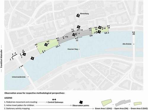
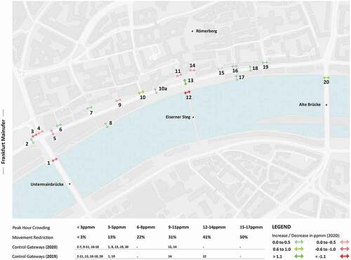
The measure addresses spatial freedom available to people moving through and along the adjacent streets connecting Mainkai. This helps in understanding which areas show high density of on-site pedestrian movement with respect to available width of space. In order to gather the data, approximately 20 control gateways (i.e. imaginary lines running across the width of a space to record frequency of persons crossing it during morning (8–9:00), afternoon (14–15:00) and evening (17–18:00) peak hours) were set up along the Mainkai stretch, neighboring non-pedestrianized streets (through points 2, 3, 4 and 19) and bridges (through points 1,12, and 20) with their respective width measurements and buffer spaces taken into consideration (). The points were positioned in a way to capture the north-south and east-west direction of movement around the pedestrianized Mainkai street, including riverside pathway (through points 8 and 17), and a bottleneck in between (through point 10a).
The selected control gateways were first measured with their respective street widths including street elements which may act as a barrier to the pedestrian movement. The available footway width was deduced after the buffer spaces with respect to the street elements were deducted. The peak hour pedestrian frequency data was gathered with the measure of pedestrian crowding calculated as follows:
Crowding = (P/W)/t (1)
where P is the peak hour frequency of persons on a gateway, W is the available footway width in metres, and t is the time of observation, i.e., 60 minutes. The recordings were measured in ppmm, i.e. persons per metre minute, being the measure for pedestrian crowding (Finch Citation2010). The on-site pedestrian frequencies were manually recorded (with persons stationed to count on control gateways without causing any obstruction to the people crossing by), during two weekdays and a weekend, which included user groups comprising pedestrians, cyclists, e-scooter users, users with reduced mobility, i.e., URM (including wheelchair users, users with cane, walkers, etc.), users with baby strollers and kids (usually aged below 12 years who are accompanied by an elder person).
Figure 3. Observation areas in Mainkai through respective methodological perspective
Children in the urban landscape
The method addresses children’s active travel behaviour (<12 years old) and their spatial representation along the Mainkai Street. It assists in understanding mobility patterns (i.e. mainly through walking and cycling) of children and their caregivers. The implementation was carried through manual observations on eight points along the Mainkai Street, which are different from pedestrian movement and crowding points (). The selection of the observation points was done through a sub-categorization of the public space, considering different aspects of the area, i.e. (a) open pedestrian areas/plazas, (b) paths/sidewalks alongside the green areas, (c) paths/sidewalks alongside the river, (d) crossing junctions with high pedestrian volume, and (e) pathways next to the high traffic and building wall (). The main objective of selecting these points was to observe the extent to which the road closure impacts the spaces which were already functioning good in terms of occupancy by children and those that were not.
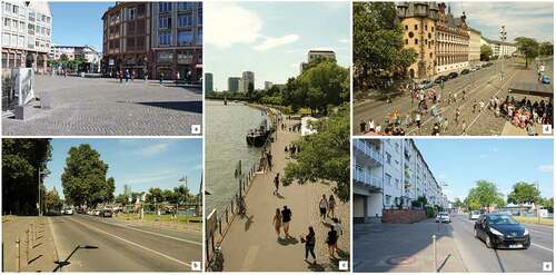
Figure 4. Different observation areas for studying mobility patterns of children i.e. on Römer plaza (a), Mainkai street (b and e), Main riverfront promenade (c), and crossing at Eiserner Steg (d)
The observations were recorded during the morning (10:30–11:30) and afternoon (15:30–16:30) hours on two week days and one weekend for pre-and post road closure scenario. The on-site observations were recorded manually through a paper sheet form, inspired from the studies of Gehl (Citation2018). The form was structured to gather information which included age of the children, behaviour and position of the children while walking and bicycling, in relation to their caregiver.
Before the road closure, the characteristics that influenced the data were the summer holidays for children and a play event on the southern bank of the river Main. While in the post-scenario, the final phase of lockdown restrictions due to the COVID-19 pandemic was ongoing, i.e. the education institutions were still closed, playgrounds were opened, and people were allowed to meet in public spaces (i.e. in groups from maximum two households). In both cases, it was expected that children were free from educational duties (school and kindergarten) and were able to be in the public space.
Stationary activities
More stationary activities in a public space reflect its ability to attract more people and use it as a space to stay, rather than a space to move through. In order to showcase any change of public space usage through Mainkai, different areas, i.e., Green Area 1 (GA1), Open Area (OA) and Green Area 2 (GA2) were identified to capture stationary activities manually through photo documentation (). The photo documentation was carried during the morning (9:00–11:30), afternoon (15:00–16:30) and evening (18:00–19:30) hours, after the peak hour pedestrian movement counts, on two weekdays and a weekend. The time duration for photo documentation during morning (or afternoon, or evening) hours was 30 minutes in each identified area. Time lapse videos were also used in similar time-period for the study, as a complementary tool to analyze different stationary activities.
In order to compare the frequency of diverse stationary activities and their spatial distribution along Mainkai (before and after the road closure), photo documentation of each area was undertaken during the mentioned time-period. Inspired by the study of Gehl and Svarre (Citation2013), the stationary activities captured through photo documentation were identified and marked on the map. The identified stationary activities were categorized into standing, sitting and physical activities. Sitting activities were subcategorized into primary (i.e. people sitting on public benches or chairs), secondary (i.e. people sitting on grass, riverbank edge, sidewalk kerb etc.), movable (i.e. people utilizing private chairs temporarily and wheelchair users), and commercial activity (i.e. people sitting in outdoor cafés and restaurants). Based on the main classification, detailed activity behaviour was mapped in order to compare the typology of stationary activities before and after road closure.
Results
Pedestrian movement and crowding
Pre-road closure scenario
The peak hour frequency data collection of pedestrian movement was carried over three days, including weekdays and weekend, considering there was no unusual event around the site, or a drastic change in the weather that may have caused an unusual spike or decline in the pedestrian frequency. Considering the individual peak hour timelines, highest frequency of pedestrians was recorded during the evening hours of weekend with 3468 pph (i.e. persons per hour) on G12 (i.e. Gateway 12), which lies on the pedestrian bridge of Eiserner Steg. With respect to overall week, highest mean pedestrian peak hour frequency was reflected over G14, which connects Römerberg plaza to Mainkai. These points being central on-site were dominated by the tourist groups, moving towards the pedestrian bridge and river.
The fast-paced user groups (including cyclists and e-scooters) were frequent on the opposite ends of the Mainkai street through two bridges of Untermainbrücke and Alte Brücke, followed by Mainkai street. The cyclists shared the riverside pedestrian pathway (G8 and G17) with the slow-paced user groups (including baby strollers, users with reduced mobility, and kids). Due to the shared space, cyclists were often observed to have their speed reduced, with the main street being dominated by the vehicular flow which lacked a dedicated bicycle pathway. Considering the available space (via footways) for people to move, the maximum crowding of 12.49 (~12.5) ppmm was recorded during the peak evening hours of the weekend along the pedestrian bridge, i.e., Eiserner steg (). This was followed by 11.84 ppmm through G14 during the afternoon hours on weekend. The high movement restriction tends to increase the closeness of walking space between people on available street widths, in turn making the two-way directional movement more difficult. In addition, bicycle accidents were observed on the shared pedestrian pathway (more frequent on G13), mostly due to uneven surface near the pedestrian bridge, tram rails and pedestrian obstruction.
Figure 5. Peak hour crowding (in ppmm) on a weekend (evening hours) along selected control gateways before and after road closure
Post-road closure scenario (during coronavirus pandemic)
Similar to the pre-scenario, the peak hour frequency was recorded during the month of May 2020, while social distancing measures in public spaces were being followed in Germany. The pedestrianized Mainkai street provided an added width of space (~10 m) for different user groups to use. This added width was taken into consideration for revised metric width per gateway (i.e. G5, G10a, G13 and G18), along with the physical interventions which had an impact on people moving through the space (e.g. extended cafe seating in open public space through G13). Due to continued construction work on street, control gateway 15 was not considered for data comparison.
With respect to individual peak hour timelines, highest frequency of pedestrians was recorded as 3366 pph over G13, showing a shift towards the pedestrianized Mainkai stretch. The gateway with highest mean pedestrian peak hour frequency remained the same, i.e., G14, leading towards Römerberg plaza, followed by Mainkai street (i.e. G13) and pedestrian bridge (i.e. G12). The frequency of cyclists dominated on the Alte Brücke (G20) and Mainkai stretch (through G10a). The road closure showed its influence on the dominance of cyclists over pedestrians through gateways, which increased to six as compared to three gateways in 2019 ().
Table 1. Overall frequency (weekly) trend during peak hours among user-groups through selected gateways on northern Mainkai riverfront, 2019-2020.’ is currently missing in this document
A decline in the maximum value of crowding was recorded after road closure, with maximum crowding of 11.27 ppmm observed through G14, showing a lower movement restriction as compared to 2019. While the maximum crowding after road closure was reduced, Mainkai street on the contrary showed an increase, especially through G13 and G8 on the riverside pathway ().
A change in the spatial distribution of user-groups utilizing different areas through Mainkai was observed after road closure. With respect to the three bridges connecting northern Mainkai riverfront, there was a major decline in the peak hour frequency of kids, followed by baby strollers, pedestrians and e-scooters (). On the other hand, users with reduced mobility and cyclists showed higher peak hour frequency on the bridges. The Mainkai street (through G5, G8, G10a, G13, G17, and G18) showed increase in peak hour frequency for all user groups (), especially cyclists (+45.83%). The road closure reflected higher utility of streets during COVID-19 pandemic by different user-groups to be within comfortable crowding range. The presence of wide Mainkai street (~10 m in width) assisted in limiting pedestrian crowding, with major control gateways having values within 5 ppmm. The riverside area (through G8 and G17) now recorded less cyclists and e-scooters, as they had to slow down due to slow-moving user groups in the earlier scenario (). The Mainkai street attracted these fast-moving user-groups, along with kids who were utilizing the space with more diverse activities. The wide pedestrianized street attracted more cyclists, baby strollers, kids in comparison to the riverside area, which showed highest increase in frequency for URM.
Figure 6. Percentage change in the peak hour frequency of user-groups on (a) all Gateways, (b) Mainkai street, (c) Mainkai riverside, and (d) Bridges during post-road closure scenario
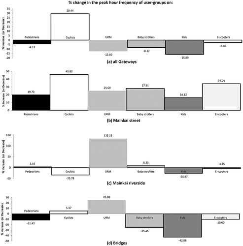
Considering all the gateways on-site (i.e. including bridges, Mainkai street and adjacent streets with/without vehicles), all user-groups showed a decline in their peak hour frequency except cyclists. This reflects how the pedestrianized street attracted more cyclists, with overall decline (−4%) in pedestrians during the pandemic scenario.
Representation of children in the urban landscape
After the road closure, the overall observed cases of children (<12 years) walking or cycling decreased by 1.15% (cases (n) in pre-scenario = 463, n post-scenario = 435). Analyzing spatial distribution of cases through observation points, the results indicated more homogeneous distribution of children during pandemic. The post-scenario showcased points 3 and 8 being used actively by children, while they were barely used before road closure. It is important to note that these observation points are different from the control gateways ().
Figure 7. Comparison of total cases of children walking (a) and cycling (b) during pre-and post road closure scenario
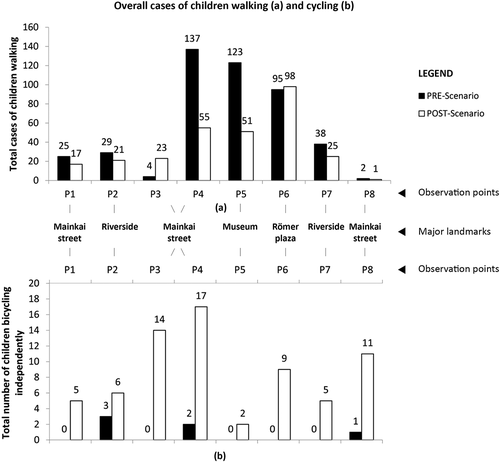
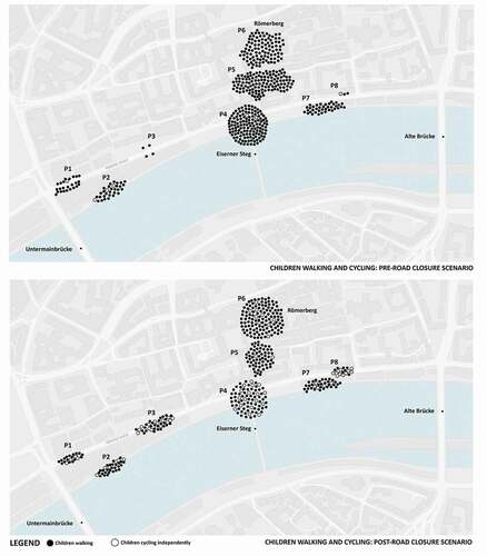
With road closure during pandemic, walking cases decreased by 35% (n pre-scenario = 453; n post-scenario = 291) while cycling cases increased by 1150% (n pre-scenario = 6; n post-scenario = 69). In both cases, more homogeneous distribution of children walking along the entire stretch was observed as compared to cycling (), and spaces that were previously not utilized by children were now occupied by them. represents children walking and cycling during the pre-and post-road closure scenario. During the pre-scenario, majority of children were observed walking and less bicycling in the area, with many walking in the central area (i.e. between Römerberg and Eiserner Steg), which compliments it being the most touristic and car-free path.
Before the road closure experiment, pathways in close proximity to green areas alongside the river (i.e. points 2 and 7) had majority of the children walking (or cycling) towards the playground, whereas spaces without any façade interaction or high traffic volume (i.e. points 3 and 8) attracted less children. With many kids observed cycling on Mainkai street (i.e. points 1, 3 and 8), a more homogeneous distribution of children was observed after road closure. A shift towards even distribution of children on central Mainkai street indicates spaces which were earlier perceived as uninteresting and dangerous, were now being actively used by children and their caregivers.
Figure 8. Representation of overall children walking and cycling during pre-and post-road closure scenario
Stationary activities
In order to analyze stationary activities on Mainkai before and after the road closure, activity numbers, typology and their locations were studied during the methodological timeline and compared as follows:
Activity number
An increased number of overall stationary activities on Mainkai was observed after road closure during pandemic (). The sitting activities were more frequent, with more people sitting on grass (i.e. GA1 and GA2) and sidewalk kerb along the pedestrianized street. New seating facilities, including fixed public benches and movable chairs, assisted in increasing the frequency of sitting activities. The commercial sitting spaces (i.e. cafés or restaurants) showed a decline in occupancy during COVID-19 on weekdays, which was in contrast to weekend numbers ().
Figure 9. Activity distribution during pre-and post-road closure scenario on a weekend (evening hours)
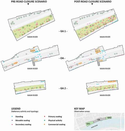
Activity typology
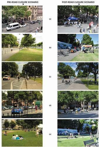
The main stationary activities on Mainkai in either scenario included people standing and sitting, yet there were changes in the overall trend. Before the road closure, major intersections along Mainkai street had traffic lights which resulted in high stationary activity (with people waiting, including major tourist groups moving towards the pedestrian bridge). In May 2020, due to the road closure intervention and Germany’s entry restriction during the pandemic, non-functional traffic lights allowed people to move freely while no tourist groups were found on-site. However, new forms of standing activities were observed on pedestrianized Mainkai street. The cafés and restaurants which were allowed to expand further to the street area, resulted in people eating and drinking while standing on the street, which was earlier dominated by motorized traffic ()). Activities by recreational clubs during weekdays contributed to more standing activities as people observed exhibitions and listened to speeches. Many cycling groups started to gather near the pedestrian bridge, contributing towards a new type of standing activity ()).
Movable sitting facilities were emerging on Mainkai after road closure, with private chairs being provided by local residents for public usage on the street ()). The street kerbs (especially towards east) were filled with planters and seats. In addition, more stationary activities by wheelchair users were observed during the road closure experiment. They were found chatting with friends in the open space near Eiserner Steg and resting on the green areas facing main river. Stationary physical activities including step test, stretching and badminton, which did not exist before on Mainkai, were observed during the pandemic period ()).
Figure 10. Comparison of space usage, during pre-and post-road closure scenarios on Mainkai street (at similar time period of the day)
Activity position
Similarities between activity positions in 2019 and 2020 were observed, with frequent standing activities along the central open space and the rail track through Mainkai. While the primary sitting behaviour dominated along the public benches in green and open areas, secondary sitting behavior was mainly observed in the green area.
Before the road closure, stationary activities were densely distributed along the riverside and on the edges of the sidewalks where traffic lights were located. In May 2020, the distribution of the activities was more scattered, expanding from riverside to street ( & & reference to time-lapse). The Mainkai street showed more standing activities which included social chatting, eating and drinking, taking pictures and other interactive activities.
With the Mainkai street closed to vehicular traffic, new benches (i.e. 15 in total) were allocated on the street near the green areas and on the stops for autonomous shuttle (which was not functioning during the study) as supporting facilities, making primary sitting activity positions more diverse (). The distribution of secondary sitting activities in green areas was more even, i.e. people used the space closer to the street through kerbs, which was in contrast to the pre-scenario where the proximity to motor traffic discouraged the usage of space. With respect to the positions of other secondary sitting activities, apart from river guard bar, more sidewalk kerb sitting activities were captured, including social exchange through chatting, reading and using smartphones ().
Discussion
A shift in observed numbers, activities and spatial distribution of user-groups utilizing the pedestrianized northern Mainkai riverfront further strengthens the argument for an urban planning that prioritizes pedestrians and cyclists over cars. It also supports the need for more quality open space during the pandemic. The main Mainkai street acts as an example of how diverse user-groups, ranging from people cycling to kids playing on street, co-exist in a safe and healthy environment.
With social distancing measures playing a major role during the COVID-19 pandemic in an urban scenario, availability of a car-free street provided a wider space for people to move and carry out different activities, contributing towards an interactive and healthy space in an urban fabric. The pedestrianization/road closure also provided an opportunity to segregate fast-paced user groups from slow-paced user groups, which was earlier shared along the riverside pedestrian area, as the main street lacked dedicated bicycle pathway (also used by e-scooters) and favoured vehicular traffic before the road closure.
Although there is an overall decline among major user-groups using various street networks, including pedestrians (by 4%), a rise in the frequency of cyclists (by 29%) showcases how a pedestrianized area attracts more users to move in a safe environment. The overall decline of pedestrians may be explained by the complete absence of international tourists due to worldwide travel restrictions during COVID-19, which might have led to an increase in overall pedestrian counts otherwise. While we observed increased numbers of moving people, a small change in stationary activities on Mainkai street was restricted to areas with a few additional benches and food stalls. This may be related to the lack of place making efforts elsewhere and points to the need of a more integrated concept including tactical urbanism.
It was expected that walking would decrease due to the COVID-19 pandemic and the lack of touristic activities at the moment. Nevertheless, it is important to note that the local people compensated the gap left by tourists. Local children were outside using the public spaces, in this case, the Mainkai street. Due to the COVID-19 pandemic, open spaces were valued in a greater way by parents and caregivers, to keep children physically active and mentally healthy. To picture this, results showed a better distribution of children along the observation points. In the post-scenario, it can be assumed due to the pandemic that the caregivers decided not to visit already crowded area (i.e. playgrounds, or the pedestrian area e.g. Römerberg plaza), but in turn utilize other available open spaces big enough for children to play and perform physical activities, avoiding close contact with individuals.
In addition, an increase in cycling trips was observed after the road closure. Even though we cannot assess in which way and to what extent the results were due to the road closure strategy or the pandemic, we assume that the pandemic had an effect on the behaviour of children and caregivers. Many parents and caregivers were opting for cycling with children, which presents as an opportunity to avoid individual contact with others (i.e. the interaction being distant as compared to playground activities, where children often interact in close proximity among themselves).
Cycling is an activity which requires more physical and mental ability than walking, especially for children (e.g. concentration, balancing, calculation of speed, etc.) and with the implementation of the traffic-calming strategy along the 800 m stretch, it presents as a perfect condition for a young child to practice bicycling. The traffic-calming experiment carried along the Mainkai street can be catalogued as successful in terms of children’s active travel patterns, since it enables a safer, accessible and friendly space, expanding the ‘active islands’ for children. It is particularly noteworthy that the Mainkai street has become a space in the hearts of the city, in which children cycling has gone up during road closure and COVID-19 pandemic. This development is not only an indication for the riverfront to be perceived as safe by parents, but also by children, which may have a long-term effect on travel behaviours among these individuals, with positive effects on health.
The increase in stationary activities after the road closure and during COVID-19 pandemic, reflected new forms of sitting, standing and other physical activities on Mainkai. More scattered spatial distribution of stationary activities was observed on, and in close proximity to, the Mainkai street. With the road closure experiment giving more priority to diverse user-groups (excluding motorized traffic), Mainkai became more pedestrian friendly, in turn attracting longer stationary use of public space. New sitting facilities along the street edges provided more opportunities for people to relax and stay, thereby implying a safe and comfortable transitional space between the street and green areas, leading towards more occupancy on the edges of the street and green landscape. In line with the above-mentioned Gehl’s report during COVID-19 pandemic, which points out people to be attracted to places that provide sensory experience and pleasant climatic condition due to human’s natural pursuit for nature, Mainkai with its green elements provides itself as a similar destination. The street space without motor traffic makes Mainkai more inclusive for new and diverse social activities.
Strengths and limitations
The paper acknowledges a rare opportunity to study public space usage in a real-life experimental set-up, i.e., pre-and post-road closure scenario during COVID-19 pandemic. It also adds to the few studies available on positive effects of the pandemic restrictions on public space use. At the same time, the overall outcome in the trend is hard to differentiate between which effects were due to the traffic-calming measures and which due to the lockdown measures during pandemic. Certain results reflected direct impact from the pandemic restrictions as the drop in the pedestrian frequency along the Eiserner Steg bridge and pathway leading to Römerberg plaza, was due to the decrease in the influx of international tourist groups. With respect to road closure, the addition of street furniture and absence of motorized traffic contributed towards increase in stationary activities (i.e. on the green areas next to the street) and cyclists on a less restricted fast-paced route, i.e., Mainkai street. While the gradual loosening of lockdown restrictions due to the pandemic might propel more users to go out in public spaces, the availability of more open spaces, especially a street, also acts as an attraction for people to carry out more diverse activities. In certainty, the overall results are an amalgamation of the two perspectives.
The methodological measurements in the study involved selection of observation areas with manual data collection. With peak hour frequency of user-groups being high in certain public areas around pedestrian bridge, minor human error in counting can be taken into consideration. With respect to the observation areas, the impact of road closure, in certainty, is reflected on a large urban scale than just the adjacent streets. Though the study includes observation points, not affected by the road closure; these are situated in immediate proximity to the pedestrianized Mainkai street. To include a control area with a neighboring street and similar conditions at a farther distance would be beneficial for future studies to be able to isolate the impact of road closure on a larger scale.
The paper is an interim report of ongoing study, with another phase of data collection for the post-road closure scenario done in July 2020, which caters less to the direct influence of lockdown restrictions due to the COVID-19 pandemic. The July 2020 results show an increase in the overall pedestrian frequency from last year by approximately 6%, whereas May 2020 data showed a decrease of 4%. With respect to the cyclists, as reflected in May 2020, July 2020 data showed an increase of approximately 20% from last year. While the COVID-19 pandemic is an ongoing scenario and impacts the summer months of 2020, the May data reflects its immediate impact (though a comparison to May 2019 data would’ve been ideal) on the public space as the lockdown restrictions were being eased. A revised data collection in 2021, given the influence of pandemic on public space usage is negligible and the road closure experiment extends for another year, would enhance the study to understand the impact of such experiments on an urban scale.
Recommendations
The Mainkai street saw an influx of different user-groups based on their speeds, i.e. pedestrians, cyclists, skateboarders and more. The riverside pathway which was earlier dominated by cyclists due to dense vehicular traffic on main street showed an increase in slow-moving user-groups post road closure. With children and adults using the open street as a medium to learn skating, cycling and perform other activities having a positive impact on health, these groups (including skateboarders) act as a buffer between the dominant fast-moving groups (i.e. cyclists) and slow-moving groups (i.e. pedestrians, baby strollers, etc.). Less children were observed walking on or along the closed Mainkai street, which may be a result of high-paced cyclists using the street. New challenges arise for Mainkai street to design spaces for diverse groups based on their speed of movement, especially with children and cyclists using the same space. There is a need to address the conflict of interest based on different speeds on the main street, with design interventions to provide a safer environment for the groups. One temporary and low-cost example for this would be painting the street in order to indicate indirectly to all users that it is a shared street and therefore caution and regulation of speed needs to be considered.
The road closure along northern Mainkai riverfront has introduced more open space for people to use, where they can run, cycle and perform various other activities to engage. Especially with the COVID-19 lockdown restrictions, such open spaces would attract people to carry out outdoor activities in a healthy environment. Opening the main Mainkai street back to the cars after the experimental timeline in September 2020 would seize away the growing trend of people engaging on the street particularly during the pandemic scenario. The study recommends to extend the traffic-calming timeline beyond the present plan, at least until the pandemic restrictions are completely eased.
Acknowledgments
This work has been co-funded by the City of Frankfurt as part of the research cooperation ‘Verkehrsberuhigung Frankfurt Mainkai’ and by the LOEWE research funding program of the State of Hessen as part of the LOEWE SP IDG/www.project-mo.de. The authors thank the project team in Frankfurt including Christa Yeung, Aboli Magire, Artur Marx, Özge Taşar, Pallavi Rao, Camilo Pfeffer and Beatriz Fontes.
Data availability statement
The data that support the findings of this study are openly available in TU Darmstadt's research data repository at https://tudatalib.ulb.tu-darmstadt.de/handle/tudatalib/2416.2.
Disclosure statement
It is important to note that we declare a potential conflict of interest. The city’s traffic planning department is led by the social democratic party (SPD), who have advocated for the road closure experiment in the past and argue in favor of its extension and the possibility of making it permanent. The department has been outspoken about the experimental character of the road closure and the need to gather data on its effects in order to evaluate its success and shortcomings, and on this basis, decide on the future of the experiment. The joint aim of the research collaboration is to study the effects of the road closure on pedestrian accessibility and urban qualities. The collaboration has partially funded for research staff (including three of the co authors) and student assistants for on-site data collection. The collaboration entailed meetings in which the co-authors presented and discussed the focus, experimental set up and preliminary results with members of the traffic planning department, and other local stakeholders including architects, researchers and planners. The research partner was not involved in writing this manuscript, but was provided with this final version and had no objection to its submission to this journal.
Additional information
Funding
Notes on contributors
Lakshya Pandit
Lakshya Pandit is a PhD student in the Urban Health Games research group at TU Darmstadt. He is working on his doctoral research within the domains of urban mobility and accessibility and is a recipient of Deutscher Akademischer Austauschdienst (DAAD) Research Grants for his research. He completed his Masters of Technology (M.Tech) in Infrastructure Systems from Indian Institute of Technology (IIT) Roorkee in 2017, and was a DAAD IIT-Masters Research Fellowship Awardee. He has worked in diverse areas of accessibility, audits, urban mobility, slum upgradation, urban health and related fields.
Gladys Vasquez Fauggier
Gladys Vasquez Fauggier is a PhD student in the Urban Health Games research group at TU Darmstadt. She is writing her thesis on ‘Urban Design Strategies to Support Active.’ She completed her Master of Science (M.Sc) in International Cooperation in Urban Development from TU Darmstadt in 2016. The background to her PhD topic is the idea that the process of ‘becoming and being a parent’ has a significant impact on a person’s mindset and activities (e.g. an increase in active travel). Accordingly, the thesis is mainly devoted to the analysis of physical active mobility in relation to the urban or metropolitan environment of parents with children.
Lanqing Gu
Lanqing Gu is a PhD student in the Urban Health Games research group at TU Darmstadt. After receiving the degree of Master of Architecture from Tongji University, Shanghai, China in 2017 and one-year teaching architectural sketch design in UPro Design School, Shanghai, she started her PhD. project at TU Darmstadt in 2018. Her research focus is on the relation between urban environment and mental health. The aim of Lanqing’s PhD. research is to identify urban design elements promoting restorative effects in arterial streets of the Frankfurt Rhein-Main agglomeration, Germany.
Martin Knöll
Martin Knöll is APL Professor of Design and Urban Planning and leads the Urban Health Games research group at TU Darmstadt. Dr. Knöll is a registered architect with a diploma and doctorate in architecture and urban planning from University of Stuttgart, Germany. His research and teaching are focused on building theory, empiric data and new people-centered approaches in urban design with the aim to guide a much needed transformation towards more inclusive and healthy cities.
References
- Brussels Environment, 2020. Focus: acoustic evaluation of the “car-free sunday” action, Available from: https://www.environment.brussels/state-environment/summary-report-2011-2012/noise/focus-acoustic-evaluation-car-free-sunday-action. Accessed 12th June 2020
- Bundesministeriums für Umwelt, Naturschutz und nukleare Sicherheit (BMU), 2017. Umweltbewusstsein in Deutschland 2016 Ergebnisse einer repräsentativen Bevölkerungsum-frage, Online Edition.
- Cairns, S., Atkins, S., and Goodwin, P., 2002. Disappearing traffic? The story so far, Proceedings of the Institution of Civil Engineers-Municipal Engineer, London, UK, Vol. 151, pp. 13–22.
- Clarke, K., 2012. Why is it so hard to be soft? How perceptions of effectiveness and acceptance of measures can be improved to encourage smarter travel, Research report, Transport Planning Society, https://tps.org.uk/public/downloads/MV83m/katie_clarke_papers.pdf Accessed 10th June 2020.
- Cortinez-O’Ryan, A., et al., 2017. Reclaiming streets for outdoor play: a process and impact evaluation of “Juega en tu barrio” (play in your neighborhood), an intervention to increase physical activity and opportunities for play. PLoS one, 2017 (12), e0180172.
- Diao, M. and Ferreira, J., 2010. Residential property values and the built environment. Transportation research record, 2174 (–1), 138–147.
- European Commission. Environment Directorate-General, 2004, Reclaiming city streets for people: chaos or quality of life?, Office for Official Publications of the European Communities.
- Finch, E., 2010. Pedestrian level comfort guidance, transport for London. Atkins, London, 7–12.
- Forbes. 2020, Paris To Create 650 Kilometers Of Post-Lockdown Cycleways, Available from: https://www.forbes.com/sites/carltonreid/2020/04/22/paris-to-create-650-kilometers-of-pop-up-corona-cycleways-for-post-lockdown-travel/#3a72e8ed54d4
- Frankfurt Stadtplanungsamt, 2014. Innenstadtkonzept Gestaltungsplan Öffentlicher Raum, Available from: https://www.stadtplanungsamt-frankfurt.de/innenstadtkonzept_5276.html
- Frankfurter Neue Presse, 2019. Verkehrschaos in Sachsenhausen – Flohmarkt soll ans Nordufer, Frankfurt, Available from: https://www.fnp.de/frankfurt/frankfurt-hessen-flohmarkt-soll-nordufer-13053695.html
- Gärling, T., et al, 2009. Implementation of Soft Transport Policy Measures to Reduce Private Car Urban Areas, First European Conference on Energy Efficiency and Behaviour, Maastricht, Available from: https://www.eceee.org/library/conference_proceedings/EE_and_Behaviour/2009/Panel_5/5.501/ Accessed 10th June 2020.
- Gehl, J. & Bernard van Leer Foundation, 2018. Toolkit for measuring urban experiences of young children, Available from: https://bernardvanleer.org/publications-reports/urban95-tools-for-studying-public-life-public-space/, Accessed 12th June 2020.
- Gehl, J., 2020. Public space & public life during COVID19, Available from: https://gehlpeople.com/announcement/public-space-public-life-during-covid-19/
- Gehl, J. and Svarre, B., 2013. How to study public life. Washington, DC: Island press.
- Gilderbloom, J.I., Riggs, W.W., and Meares, W.L., 2015. Does walkability matter? An examination of walkability’s impact on housing values, foreclosures and crime. Cities, 42, 13–24.
- Halblaub Miranda, M., et al., 2019. PREHealth: Designing health into urban green and blue infrastructures–The need for action in planning, policies, and research. International Synthesis Report. urn:nbn:de:tuda-tuprints-83525. TUprints-TUDarmstadt: Darmstadt, Germany. https://tuprints.ulb.tu-darmstadt.de/8352/6/IO1_ISR.pdf.
- Hass-Klau, C., 1989. The pedestrian and city traffic : the history of protecting pedestrians and residents from the effects of wheeled and motor traffic with special reference to Britain, Germany and the United States, Forschungsberichte der Bundesanstalt für Straßenwesen, Bereich Unfallforschung, 204, Available from: https://opus4.hbz-nrw.de/frontdoor/index/index/searchtype/series/id/11/start/9/rows/25/yearfq/1989/docId/1416.
- Juhász, M. and Koren, C., 2016. Getting an insight into the effects of traffic calming measures on road safety. Transportation research procedia, 14, 3811–3820.
- Karndacharuk, A., Wilson, D.J., and Dunn, R.C., 2013. Analysis of pedestrian performance in shared-space environments. Transportation research record, 2393 (1), 1–11.
- Kjemtrup, K. and Herrstedt, L., 1992. Speed management and traffic calming in urban areas in Europe: A historical view. Accident analysis and prevention, 1, 57–65.
- Korte, C. and Grant, R., 1980. Traffic noise, environmental awareness, and pedestrian behavior. Environment and behavior, 12 (3), 408–420.
- Larsen, L., et al., 1978. Faerdselslov §40 Nye formerfor trafiksanering, Betrenkning nr. 827. Justitsministeriet.
- Leape, J., 2006. The London congestion charge. Journal of economic perspectives, 20 (4), 157–176.
- Leinberger, C.B. and Alfonso, M., 2012. Walk this way: the economic promise of walkable places in metropolitan. Washington, DC: The Brookings Institution.
- Litman, T.A., 2011. Economic value of walkability. World transport policy & practice, 10 (1), 5–14.
- Longo, A., et al., 2015. Demand response to improved walking infrastructure: A study into the economics of walking and health behaviour change. Social Science & Medicine, 143, 107–116.
- Lydon, M. and Garcia, A., 2015. Tactical urbanism short-term action for long-term change. Washington, DC: Island Press.
- März, S., et al., 2020. Lebenswerte” Straße in resilienten urbanen Quartieren: Projektergebnisse eines Teilprojektes im Gesamtprojekt” Eckpunkte für die Umsetzung einer Landesstrategie zur Klimaanpassung aus wissenschaftlicher Sicht.
- Mason, M., et al., 2011. Ciclovìa in Chicago: a strategy for community development to improve public health. Community development, 42 (2), 221–239.
- Meyer, M.R.U., et al., 2019. Systematic review of how play streets impact opportunities for active play, physical activity, neighborhoods, and communities. BMC public health, 19 (1), 335.
- Montgomery, C., 2013. Happy city: transforming our lives through urban design. New York, USA: Macmillan.
- Mullin, J.R., 1977. City planning in Frankfurt, Germany, 1925-1932: A study in practical utopianism. Journal of urban history, 4 (1), 3–28.
- National Association of City Transportation Officials, 2013. Urban street design guide. New York: Island Press.
- Nevelsteen, K., et al., 2011. Controlling factors of the parental safety perception on children’s travel mode choice. Accident; analysis and prevention, 2012 (45), 39–49. doi:10.1016/j.aap.2011.11.007
- Nieuwenhuijsen, M.J. and Khreis, H., 2016. Car free cities: pathway to healthy urban living. Environment international, 94, 251–262.
- Nikolaeva, A., 2012. Designing public space for mobility: Contestation, negotiation and experiment at Amsterdam airport Schiphol. Tijdschrift voor economische en sociale geografie, 103 (5), 542–554. doi:10.1111/tesg.2012.103.issue-5
- Papagiannakis, A. and Vitopoulou, A., 2015. An urban strategy in time of crisis: mobility management and low-cost public space design, Spatium: 1-7.
- Project for Public Spaces. 2008, Traffic calming 101, Available from: https://www.pps.org/article/livememtraffic
- Sadik-Khan, J., 2013. Urban street design guide. New York: NACTO, Island Press Available from: https://nacto.org/publication/urban-street-design-guide/interim-design-strategies/temporary-street-closures/ Accessed .
- Sandahl, J. and Lindh, C., 1995. Impact of improving the attractiveness of town centres. Transport policy, 2 (I), 5I–56.
- Soni, N. and Soni, N., 2016. Benefits of pedestrianization and warrants to pedestrianize an area. Land use policy, 57, 139–150.
- The Guardian, 2020. Milan announces ambitious scheme to reduce car use after lockdown, Available from: https://www.theguardian.com/world/2020/apr/21/milan-seeks-to-prevent-post-crisis-return-of-traffic-pollution
- Transport for London., 2020. Streetspace for London, Available from: https://tfl.gov.uk/travel-information/improvements-and-projects/streetspace-for-london
- United Nations, Department of Economic and Social Affairs, Population Division, 2018. World urbanization prospects: the 2018 Revision. New York: Online Edition. Available from: https://population.un.org/wup/Download/.
- von Schönfeld, K. C. and Bertolini, L. 2017. Urban streets: epitomes of planning challenges and opportunities at the interface of public space and mobility. Cities, 68, 48–55.
- Willsher, K., 2015, Paris’s first attempt at car-free day brings a big drop in air and noise pollution. https://www.theguardian.com/world/2015/oct/03/pariss-first-attempt-at-car-free-day-brings-big-drop-in-air-and-noise-pollution. Accessed 12th June 2020.
- Wolf, S. A., et al., 2015. The impact of a temporary recurrent street closure on physical activity in New York City. Journal of urban health, 92 (2), 230–241. doi:10.1007/s11524-014-9925-0
- World Health Organization, 2018, Physical activity, Available from: https://www.who.int/news-room/fact-sheets/detail/physical-activity
- Zeedyk, M.S. and Kelly, L., 2003. Behavioural observations of adult–child pairs at pedestrian crossings. Accident analysis & prevention, 35 (5), 771–776.