
Abstract
This article considers Amazonian environmental change by focusing on political and economic processes in a place-specific context with far-reaching global implications. In particular, we consider the destruction of the Brazil nut forest (BNF) in the lower basin. The Brazil nut tree yields a valuable nontimber forest product, and its loss raises concerns about Amazonia’s agro-ecological sustainability. The article posits the destruction of the BNF as an outcome of land creation, the transformation of soil surfaces into a production factor for market-oriented agriculture. Land creation in the lower basin sparked violent conflict, with the destruction of the BNF as collateral damage. Our account complements earlier research on the political economy of Amazonian development by providing an update tuned to the institutional and economic changes that have led to the region’s engagement with globalized beef markets and to the transformative impact on implicated actors (i.e., peasant, capital, and the state). In addition, the article uses the BNF case to consider current threats to Amazonia. In Brazil, deforestation rates declined after the turn of the millennium, due to environmental policy. Recent numbers show deforestation on the rise, however, as South American nations fast-track large infrastructure projects to transform Amazonia into a transport hub and a continental source of hydropower. The article questions whether Brazil’s environmental policies will sustain the Amazonian forest over the long run; the BNF disappeared despite efforts at conservation buttressed by legislative action. The article uses data from surveys, remote sensing, regional newspapers, and secondary sources based on declassified documents from Brazil’s Armed Forces, the National Truth Commission, and the Central Intelligence Agency (CIA). Key Words: Amazon, deforestation, IIRSA, land grab, resource conflict, sustainable development.
本文聚焦一个具有深远全球意涵的特定地方脉络中的政治经济过程, 考量亚马逊的环境变迁。我们特别考量巴西下游河段坚果树森林(BNF)的破坏。巴西坚果树生产了有价值的非木材森林产品, 而其损失则引发有关亚马逊农业生态可持续性的关注。本文将BNF的破坏断定为土地创造的结果——土壤表层转化为以市场为导向的农业之生产要素。下游河段的土地创造, 引发了暴力冲突, 并以BNF的破坏作为附带的损害。我们的解释, 提供考量导致该区域参与全球化牛肉市场的制度与经济变迁, 以及对于涉及的行动者(例如农民、资本与国家)的转型冲击之最新信息, 以此补充早期亚马逊的政治经济研究。此外, 本文运用BNF的案例, 考量对于亚马逊的当前威胁。在巴西, 环境政策使得去森林化的速度在千禧年之后开始降低。但晚近的数据显示, 由于南美国家快速通过将亚马逊转变为运输枢纽和该大陆的水力发电资源的大型基础建设计画, 去森林化正逐渐发生。本文质问巴西的环境政策是否可长期维系亚马逊的森林;尽管立法行动支持保育的努力, BNF却仍消失。本文运用调研、 遥测于区域报纸的数据, 以及根据巴西武装部队、国家真相委员会和中央情报局(CIA)的解密文件的二手资源。 关键词:亚马逊, 去森林化, IIRSA, 土地掠夺, 资源冲突, 可持续发展。
Este artículo considera el cambio ambiental amazónico, concentrándose en los procesos políticos y económicos dentro de un contexto específico por lugar con implicaciones globales de vasto alcance. En particular, concentramos nuestra atención en la destrucción de los bosques de nueces del Brasil (BNF) en la cuenca baja. El árbol de nueces del Brasil rinde un valioso producto forestal no maderero y su pérdida genera preocupaciones acerca de la sustentabilidad agro-ecológica de la Amazonia. El artículo plantea la destrucción de la BNF como resultado de la producción de tierra, o sea la transformación de superficies edáficas en un factor productivo para la agricultura orientada a mercado. La producción de tierra en la cuenca baja desató una condición de conflicto violento, con la destrucción de la BNF como daño colateral. Nuestro recuento complementa la investigación anterior sobre la economía política del desarrollo amazónico al suministrar una actualización ajustada a los cambios institucionales y económicos que han conducido al involucramiento de la región en los mercados globalizados de la carne de res y al impacto transformador sobre los actores implicados (esto es, campesinos, capital y el estado). Por otra parte, el artículo toma el caso de la BNF para considerar las amenazas que actualmente se ciernen sobre la Amazonia. Como resultado de las políticas ambientales, las tasas de deforestación disminuyeron en Brasil a la vuelta del milenio. Sin embargo, los datos recientes muestran que la deforestación está otra vez en aumento en la medida en que las naciones sudamericanas impulsan grandes proyectos infraestructurales para transformar la Amazonia en una gran estructura de transporte y en fuente continental de abastecimiento hidroeléctrico. El artículo pone en duda que las políticas ambientales del Brasil puedan sustentar la selva amazónica en el largo plazo; la BNF desapareció a pesar de los esfuerzos de conservación apuntalados por la acción legislativa. El artículo usa datos de estudios de campo, percepción remota, periódicos regionales y fuentes secundarias basadas en documentos desclasificados de las Fuerzas Armadas del Brasil, la Comisión Nacional de la Verdad y de la Agencia Central de Inteligencia (CIA).
This article considers Amazonian environmental change by focusing on the articulation of political and economic processes in a place-specific context with far-reaching global implications. In particular, we consider the destruction of the Brazil nut forest (BNF) in the lower Amazon Basin, a region that accounts for nearly 17 percent of all deforestation in the Brazilian Amazon up to 2010 (National Institute of Spatial Research [INPE] Citation2012). Until recently, the BNF (∼20,000 km2) formed unusually dense concentrations of Brazil nut trees (Bertholletia excelsa, Lecythidaceae), which sustained a profitable extractive economy in the first half of the twentieth century (). By historical accident, the BNF lay in the development pathway of Brazil’s military government (1964–1985), for it was here that road-building crews opened the Amazonian forest to occupation with the construction of BR-230, the so-called Transamazon Highway. Thus, it should come as no surprise that the forest has largely disappeared given the encroachment of agricultural land use, mainly dedicated to Amazonia’s burgeoning cattle sector (Simmons et al. Citation2007; Walker, Browder, et al. Citation2009; Aldrich et al. Citation2012; R. Pereira, Simmons, and Walker Citation2016). The Brazil nut tree is majestic. It grows to heights of more than 150 feet, lives for a thousand years, and yields a valuable nontimber forest product (Shepard and Ramirez Citation2011; Rockwell et al. Citation2015). Thus, loss of the BNF raises concerns about the prospects of discovering a sustainable alternative to agriculture and ranching in the basin (Balée Citation1989; Homma et al. Citation2000). It also points to a state-led process of environmental change that places the entire Amazon Basin at risk of ecological degradation. This risk arises from the economic imperative to transform natural areas into land, a factor of production at the service of capital (Walker and Simmons Citation2018).
Brazil’s present-day expanse of ∼8.5 million km2 accounts for nearly 7 percent of the planet’s terrestrial surface. Agricultural land use covers 3.3 million km2, an area that has doubled since 1920 (Brazilian Institute of Geography and Economy [IBGE] Citation2006).1 Although agriculture contributed to Brazil’s economic expansion starting with the conquest, the sector’s prime production factor, land, did not spring freely from nature. Rendering land to the factor markets of the world system, or land creation, involves physical changes and social processes that transform soil surfaces into the input that capitalist agents use in pursuit of profit maximization. When this occurs on forested landscapes, typically with agricultural encroachment, deforestation is the necessary result. We use the term land creation rather than land commodification to encompass both the creation of a factor of production and the physical process of vegetative clearance, the proximate cause of deforestation.
Amazonian land creation in the twentieth century precipitated a number of resource conflicts, most notably in the lower basin, where the Brazilian military regime, after toppling President Goulart in 1964, implemented policies to develop Amazonia by way of fiscal instruments and investments in transportation and hydropower. Loss of the BNF, the spatial epicenter of this developmental quest, must be interpreted as the outcome of the land creation process that these policies sparked, pursuant to the Brazilian state’s interest in capturing resources and securing the borders of a sparsely settled region (Foresta Citation1992; Hecht Citation2013). It is the goal of this article to provide an explication of the land creation process as it unfolded in the BNF. We seek an understanding contingent on the BNF’s unique history but useful as a case study of land change in forest frontiers more generally.2
Declines in Amazonian deforestation rates following the turn of the millennium, and ongoing processes of forest transition in many parts of the world, have brought hope that the hemorrhaging of tropical forests worldwide has at last begun to slow (Walker Citation1993; Virgilio Citation2009; Hecht Citation2014; Nepstad et al. Citation2014). In the Brazilian case, environmental policies and nongovernmental organization activism, as well as Brazil’s commitments to mitigate global climate change, reduced the rate of Amazonian forest decline steadily between 2004 and 2013, with fluctuations continuing to the present time including a recent uptick.3 Unfortunately, optimism might be premature, given economic and political turmoil in Brazil, which has weakened its commitment to the Amazonian environment and led to downsizing of protected areas in the interest of resource exploitation and infrastructure development (Laue and Arima Citation2016; Crouzeilles et al. Citation2017; Overbeck et al. Citation2018).4 This is all the more worrisome in light of the desire of South American nations to transform Amazonia into a multimodal transportation hub and continental source of hydropower, via its Initiative to Integrate the Infrastructure of South America (IIRSA) and complementary national and state projects.5
From an analytical perspective, converting a hopeful decline in deforestation rates into a permanent outcome would require an end to land creation. Thus, to ask whether Brazil will finally turn the corner on Amazonia is to ask whether Brazil’s demand for land will dissipate, as environmental consciousness materializes a policy enforcement regime consistent with international climate change accords. Or, does the recent destruction of the BNF spell doom for the forest cover that remains in the basin?
In attempting to answer this question, we first consider the political economy of development for the Amazonian case and the article’s conceptual extensions in this regard. With preliminaries in place, we next discuss Amazonia’s land creation process and its mediation by antagonistic agents, considering the influences of state power and spatial development strategy; we empirically ground this in the history of social conflict and forest loss in the BNF and in contemporary conditions. Once up to date with the development story, we describe the final outcome, a highly capitalized cattle economy tied to global markets via global production networks. In concluding, we consider the implications of our findings for the rest of the Amazon basin.
The scholarship addressing Amazonian development is vast. Our narrative necessarily repeats parts of an old story, which we attempt to update by considering new information taken from both our research findings and secondary sources of relatively recent vintage. The declassification of documents by the Brazilian armed forces allows us to add detail to the development narrative heretofore lacking. With a case study of the BNF, the article reveals dynamics in the relationships between social processes and environmental change. As such, it provides insight into how deforestation drivers and implicated agents have evolved through five decades of development interventions in the Amazon Basin (García-Barrios et al. Citation2009; Gomes, Vadjunec, and Perz Citation2012; Hecht Citation2014; R. Pereira, Simmons, and Walker Citation2016).
The Political Economy of Amazonian Deforestation
Efforts to comprehend the opening of the Amazonian frontier through the latter half of the twentieth century have often relied on political economy to frame the process as a capitalist conquest of new frontiers (Foweraker Citation1981; Sawyer Citation1984; A. Hall Citation1987; Schmink and Wood Citation1992). Much of the early work focused on the lower Amazon Basin, regarded as an arena of contested frontiers representing diverse, conflicting interests. A key theme of this literature is the role played by the Brazilian state, particularly the military government, which pursued a “high modernist” development plan in the late 1960s and 1970s, thereby setting the stage for occupation and resource exploitation. Evidently, geopolitics motivated the generals, in particular concerns about the territorial integrity of Amazonia, given a history of conflict with Bolivia and Peru over international borders (Foresta Citation1991, 1992; Hecht Citation2013). Although the federal government emphasized a colonist agenda aimed at Brazil’s rural poor, early development benefits, in the form of fiscal incentives, accrued primarily to corporate interests and wealthy ranchers, many of them from the south (Hecht Citation1985; A. Hall Citation1987; Santana et al. Citation1997; Simmons Citation2004).
Political economy addresses the distal drivers of Amazonia’s environmental change processes, primarily at an aggregate scale, with a focus on the state and capital. For its part, land change science (LCS) has approached Amazonian deforestation mostly with statistical models, across a range of scales, from detailed studies of individual households to the basin at large. In general, LCS has conceptualized Amazonian forest loss as an effect of rational economic behavior, enabled by large-scale infrastructure investments (Walker, Moran, and Anselin Citation2000; Brondızio et al. Citation2002; Walker Citation2003; Pfaff et al. Citation2007; Arima et al. Citation2013). Land managers (e.g., smallholders, ranchers, soybean farmers) maximize welfare or profits after transportation infrastructure has lowered production costs. LCS pays little attention to the higher order processes that precipitate infrastructure investment, and the land manager is often represented as a smallholder, given the ready availability of cadastral maps for colonization areas (Walker Citation2003; Caldas et al. Citation2007; Browder et al. Citation2008).
Political economy and LCS shed light on Amazonia’s interwoven processes of development and environmental change. They do not, however, tie together the macroscale factors affecting ground-level processes of social and environmental change and the microscale events and circumstances that constitute these processes through the actions of embodied agents. Nor do they recognize the dynamic nature of Amazonia’s developmental processes and therefore mostly overlook the ongoing evolution of its deforestation drivers. Finally, they do not address the role of conflict and how social contention links directly to specific instances of forest loss.6
In attempting to overcome such limitations, this article complements LCS by embedding ground-level agents in a contentious social matrix that produces Amazonian deforestation via acts of land creation. It also complements the political economy scholarship by providing an update on the evolution of Brazil’s institutional and economic structures that govern the form and power of distal drivers. Of great importance here is that the national development plan of the military government has given way to a much more ambitious continental initiative in the form of IIRSA (Walker and Simmons Citation2018). Further, neoliberal reforms have shifted deforestation behavior at ground level from rent seeking to profit maximization within a global market economy (Walker Citation2014).
The Existential Constructs of Land Creation
The starting point for assessing the nexus between economy and environmental change in Amazonia resides in considering the phenomenon of land creation. Our conceptualization provides a temporal frame restricted to the current epoch of capitalist production relations, with fully developed factor and commodity markets. We further restrict this to the period starting with the military government. Because the study is limited to the BNF, our analysis is circumscribed both temporally and spatially. This enables us to frame deforestation as the result of a land creation process involving two agents we refer to as the camponês and taker. The Communist Party of Brazil (PCB) argued in the 1930s that industrialization had created a social binary in rural areas, defined by the relationship to land.7 We adopt this convention and use camponês as our rural “poor” category and taker for those who are “landed.” Note that such categories are historically defined and in this case have experienced significant transformation.8 For example, beef production chains have created new niches for labor and therefore new social categories defined by articulation with the cattle economy. As a consequence, the camponês population has in large part given way to the smallholder, engaged in calving operations, as discussed in the sequel.
Land creation starts with the migration of the camponês to the agricultural frontier and then beyond into nature-space, what von Thunen referred to as “uncultivated wilderness” (Foweraker Citation1981; Martins Citation1981). The preparation of the physical substrate follows, with peasant labor transforming the landscape from forest ecosystem to subsistence farming. Takers come upon the camponês, exerting all manner of stratagem (e.g., falsified titles, murderous violence) to seize their holdings and valorize them by exchange into land markets or by activation as factors of production for commercial agriculture (Foweraker Citation1981; Martins Citation1981). The taker reaps capital gains by virtue of primitive accumulation in the form of a land grab, and the camponês finds his or her fruits of labor in another person’s hands (Martins Citation1981; Hecht and Cockburn Citation1989; Schmink and Wood Citation1992). Taking situates agents in an antagonistic dyad of historic and geographic reach.9 In the lower basin, this has involved both land seizures from indigenous peoples by the camponês and from the camponês by capitalistic takers. Our focus resides on the victimology of the camponês, in that we limit our analytical discussion to the recent rendition of land from the Amazonian forest into fully marketized economy.10
The word taking draws immediate attention to our terminological choices, in that it is synonymous with grabbing, as in land grab. Our usage rests on several analytical distinctions. One is that taking is meant to represent the initial grab following the conversion of nature into land. It is an initial act of violence that sets the stage for subsequent grabs, possibly involving a multiplicity of actors at varying spatial scales (Peluso and Lund Citation2011; Borras et al. Citation2012; Smalley and Corbera Citation2012). Another distinction is that the term grab is now used in a variety of settings and for a variety of resources (e.g., water, energy, meat), even across global production chains (Wolford et al. Citation2013; R. Hall et al. Citation2015). Although we focus attention on a foundational dynamic engaging the camponês and taker, with an initial grab aimed at capitalizing agricultural production and marketizing land, we recognize enclosures affecting the BNF in the early twentieth century, as well as the contemporary “meat grab,” which has embedded control over land parcels occupied by former camponês within echelons of global production networks (S. L. Pereira and Sauer Citation2011; Schneider Citation2014; Nally Citation2015; R. Pereira, Simmons, and Walker Citation2016). Thus, the concepts of land creation and taking deployed by our analysis fit within a broader historical cycle of land grabbing (Edelman and León Citation2013; Edelman, Oya, and Borras Citation2013), with successive applications of discipline by the state to make legible territory to promote progress and ensure security (Borras et al. Citation2012; G. Oliveira Citation2013). Such cycles, in turn, might track transformations in the landscape, regional economy, and implicated actors, as domestic agricultural production is subsumed within a globalized food system (McMichael Citation2005, Citation2012; Cotula Citation2012; Schneider Citation2014).
Disciplinary Considerations
Development in the lower Amazon Basin requires both land creation and land use. These in turn require discipline, which we define as a mechanism for the application of power meant to control bodies and dedicate them to objectives such as wealth accumulation, regional development, and so on. Of interest to this case are three modes of discipline affecting the organization of space (cartographic), the performances of the body (corporeal), and economic behavior within a matrix of perceived costs, benefits, and prices (market).11 These disciplines, in turn, are exercised by both the state and taker, given the congruency of their objectives and their social complicity. The camponês provides the body to be controlled and managed for systemic purposes.
Cartographic discipline emerges from the spatial rationality that conditions state planning for the efficient administration of territory and citizenry, a prerequisite for high modernist engineering projects such as undertaken by the Brazilian military government (Scott Citation1998). It enables state response to matters of national security, with cartography making legible internal and external threat environments (Harley Citation1988; Belyea Citation1992; Smith 1992; Crampton Citation2003). Cartographic discipline as implemented in the Amazonian case involves infrastructure investment leading to the construction of road networks, which forcibly differentiate the homogenous template of nature into a geometric pattern (Blomley Citation2003).12 The in situ map thus created inscribes a landscape, making legible the resources to be extracted and, at later stages, emergent threats. It also provides for the capillary movement of bodies across a two-dimensional terrain and facilitates the application of military force should state legitimacy be challenged. In sum, cartographic discipline enables surveillance, military intervention, and the execution of high modernist plans.
In our usage, corporeal discipline includes performances of murder, mass murder, torture, beatings, the destruction of property, and all manner of assaults on the body. Violence is not an instrument of public spectacle, and its purpose is not to demonstrate simply the power of the state (Oksala Citation2010). Rather, violence serves both the state and taker by making bodies docile in the interest of a new economy. At the outset, this economy requires that the camponês pursue a set of gainful activities in accord with rational purpose but only to the point of expropriation, when he or she is made docile by “absence,” through either death or expulsion from the land. Although violence often creates terror, its larger purpose in the BNF had been to clear the deck for the rendering of land to markets (Evans Citation2010).13 Complementing this disciplinary mode are actions of the state designed to weaken insurrectionary force with carrots rather than sticks. The policy forms these actions take are corporeal blandishments including the provision of transfer payments and institutional support for rural livelihoods.
Market discipline, the successor to corporeal discipline in the BNF, situates and controls its economic bodies in a web of exchange driven by infusions of capital and by behaviors dedicated to economic gain. In the (former) BNF, applications presently involve the smallholder, ontological heir of the camponês. Under this disciplinary modality, docility of the body is achieved not by absence but by market arrangements that trap the smallholder in production chains controlled by corporate capital distal to the BNF (Baglioni and Gibbon Citation2013; Selwyn Citation2015). Docility arises by internalization of the quest for capital and a willingness to abide by the Darwinian rules of the market. Given disciplinary force is diffuse and spread globally, it remains largely invisible, and regulated bodies might even come to believe the “system” benign, a servant to personal interests. Currently in the former BNF, smallholders reflexively perform their own surveillance and disciplinary functions (Foucault Citation1977).
Thus, our disciplinary concept is multidimensional and dynamic and involves the state, takers, and global capitalism via a market system. The state exercises cartographic discipline, and the state and taker exercise corporeal discipline. Once an economy emerges, market discipline comes into play, an instrument of the global economic system (Jessop Citation2006). Discipline in the BNF evolves through time and agency. It inscribes itself on the bodies of both camponês and its heir, the smallholder. One is marked with death, the other with exploitation.
Historical Context
Our discussion to this point neglects the contingencies of place as they have affected the BNF. Further, it has only presented a stylized account of the adversarial encounter between camponês and taker. To activate the existential conflict for the case at hand, we now lay out the broad historical stage on which the BNF has given way to a cattle economy embedded in global markets.
Early Twentieth Century: Forest-Based Extractive Economy
The camponês begins to infiltrate Amazônia in the 1800s, providing service to the world system initiating its long industrial swing based on steel and rubber (Jackson Citation2008). A later influx in the early twentieth century was stimulated by Padre Cícero, whose prophecies about the Bandeiras Verdes (green flags) of the Amazonian forest inspired the rural poor of the northeast of Brazil to leave behind impoverished lives to pursue a “freedom dream” in the lower basin (Cardoso and Muller Citation1977; Vieira Citation2001; Hebette and Marin Citation2004). As the rubber economy collapsed in 1912, economic depression gripped the entire basin except for the southeastern corner of Pará, where rising Brazil nut prices accelerated the settlement and growth of Marabá, with its unusually dense groves (Foweraker Citation1981). Consequently, mercantile capitalists, who controlled product storage, transport, and marketing, and the resident camponês, who provided labor power to the mercantilists and engaged in their own subsistence farming, found common ground in limiting the extent of land creation, as nature-space yields a valued commodity without the instrumentality of land. With time, mercantile capital integrated to the castanhais, individual concentrations of Brazil nut trees. This transformed open access resources into private ones, under freehold ownership or long-term leases with the state of Pará, the aforamento (Ianni Citation1979; Emmi Citation1988; Schmink and Wood Citation1992). Mercantile capital thereby created a local oligarchy composed of several families that controlled all stages of Brazil nut production, processes, and marketing.
1960–1974: Military Government and the Guerrilha do Araguaia
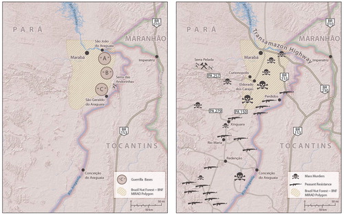
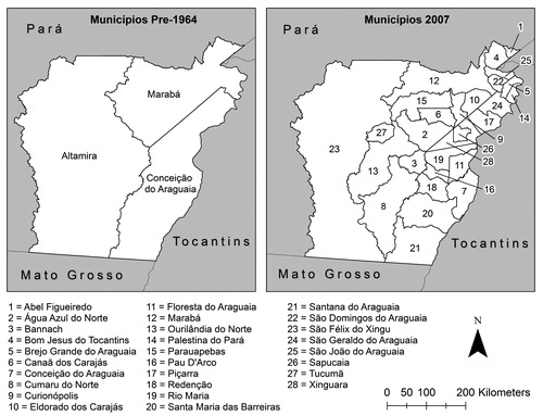
Rubber and Brazil nut extraction attracted a camponês population of several thousand to the western banks of the Araguaia River in the vicinity of Marabá. Then, developmental programs advanced by Presidents Vargas (1930–1945, 1951–1954) and Kubitschek (1956–1961) brought 2 million to just east of the region, mostly from the northeast (Cardoso and Muller Citation1977; Hebette and Marin Citation2004).14 Sulistas, agroindustrial takers from São Paulo and other southern states, streamed north, exciting Amazônia’s ancien regime, which granted them forest tracts with populations of camponês already long settled (Almeida Citation1991, Citation1994). A tidal wave of taking built along the margins of the BNF, in the borderlands between Pará State and Mato Grosso; this began in the early 1960s and grew exponentially after the Brazilian Armed Forces took power from President Goulart in 1964. Camponês resistance to taking arose in this period, stimulated by the serendipitous arrival of Maoists from the Communist Party of Brazil (PC do B), who selected the BNF as their Shaanxi province for a “people’s war” that would arc across the north (Studart Citation2006). About seventy militants infiltrated by the late 1960s, setting up three bases of operation between Marabá and the Araguaia River, a region at that time far from roads and concealed by dense BNF canopy (see , left panel, adapted from Morais and Silva Citation2005; Morais Citation2008). The military government declared the area a national security zone and authorized an assault on the revolutionaries and their camponês sympathizers, in what has become known as the Guerrilha do Araguaia (1972–1974), or the Araguaia Guerrilla War (A. U. Oliveira Citation1988; Morais and Silva Citation2005).
Figure 1 Brazil nut forest in the lower Amazon Basin.
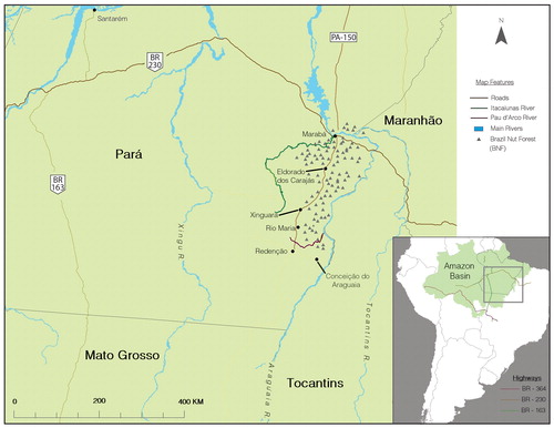
Figure 2 Conflicts in Brazil nut forest. Note: The left panel reproduces the locations of the three Communist Party of Brazil commands (Morais and Silva 2005). The right panel gives sites of armed resistance by camponeses as well as locations of mass murders (1981–1990). Sites of armed resistance are reproduced from R. Pereira (2006). Mass murders are taken from newspaper archive in possession of authors (Opinião! and O Correio do Tocantins), containing 4,139 pages, with one to ten reports of land conflict violence per page. MIRAD = Ministry of Agrarian Reform and Development.
1974–2000: Luta Posseira and Direct Action Land Reform
The Brazilian army quickly defeated the Maoist insurgents. This did not pacify the region, though, as the Guerrilha initiated the Luta Posseira (Peasant Struggle), two decades of conflict intensified by in-migrations following the (1) discovery of gold at Serra Pelada in 1979 and (2) initiation of iron-ore export from the Carajás mine starting in 1985 (A. Hall Citation1987; Schmink and Wood Citation1992; Simmons Citation2005). As the militarists left power in the mid-1980s, the BNF became a battleground for the second time in ten years with the Guerra dos Castanhais (the War of the Brazil Nut Groves), a conflict between the camponês and the Brazil nut oligarchy over control of the castanhais (Bentes, Marín, and Emmi Citation1988; Emmi Citation1988; Barata Citation1995). (right panel) shows that violence engulfed the entire southeastern region of Pará; it was most extreme in the BNF, where mass murders tended to concentrate (Kotscho Citation1981; Americas Watch Citation1991; Barata Citation1995; Veja Citation1996; Simmons Citation2004).
Although the Brazil nut oligarchs mainly defeated the camponês, they grew fearful of losing their extractive economy to agroindustrial Sulistas even though most Sulista holdings were south of the BNF.15 Consequently, Brazil nut interests articulated a conservation rhetoric and helped craft environmental legislation to protect the BNF (Emmi Citation1988).16 In a last-ditch effort to secure their resource claims, the oligarchs asserted political influence on the state of Pará to (1) establish the Brazil Nut Polygon (BNP), an ∼6,800-km planning region near the city of Marabá, and (2) transition aforamentos into private property. Behind the smokescreen of the conservation discourse, the oligarchs hastened their own transformation into fazendeiros (ranchers) with the aid of government development subsidies, blaming the failure of environmental protection on the necessity of their own submission to the discipline of location rents from ranching (Kitamura and Muller Citation1984). Although the land statute on aforamentos limited holding size to 3,600 ha, they concentrated over time to an average of 4,500 ha, with the largest at 56,000 ha (Emmi Citation1988).
With democratization in 1985, the Luta Posseira closed, as organized resistance led by rural syndicates (STRs) and landless movements, such as the Movement of the Landless Rural Workers (MST), undertook a program of direct action land reform (DALR) that mobilized mass occupations of the castanhais deemed to violate the social function mandate of the 1988 constitutional land statute (Simmons Citation2004). This ushered in a phase of contentious land change, pitting the mercantile capitalists (in transition to ranchers) against social movement organizations (SMOs) and their mobilized cadres. The outcome by 2010 was land creation across most of the former BNF, with extensive deforestation.
Discipline and Develop
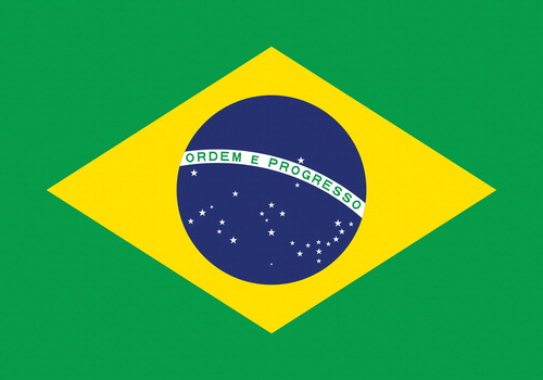
The Brazilian flag heralds orden e progresso, or order and progress, as the nation’s foundational slogan (). By a substitution of synonyms, the slogan might also be rendered as discipline and development, a verbal conjunction that privileges discipline over development, an order suggesting its primacy as the action that achieves the developmental outcomes. This constitutes our foundational understanding of developmental processes. Specifically, development requires the application of successive modes of discipline to realize a spatially efficient investment pattern and to ensure that social and economic outcomes are consistent with the objectives of those who deploy discipline in the first place. We now consider such deployments for Amazonia and the BNF.
Figure 3 Discipline and Develop, slogan of Brazilian flag (translation by authors).
Cartographic Discipline
Spatial actions by governmental agents begin with the implementation of an upper-tier federal road system and its sparse rectangular network spanning the basin, the most vaunted of early developmental efforts meant to link the Amazonian periphery to the rest of Brazil. The land route connecting Belém to the new capital, Brasília, or Belém–Brasília, opened under the administration of President Kubitschek in 1960, a key marker in the reconfiguration of twentieth-century Brazil, particularly for the state of Pará and the BNF, given that it passes less than fifty miles east of the Araguaia River. This spatial watershed set in motion successive investment waves and migrations. The sudden onset of cartographic relation began to pull Amazonia into the Brazilian nation as a fully fledged region (Mahar Citation1979; Bunker Citation1982). The military government (1964–1984) followed Kubitschek’s initiative with its own infrastructure program (Moran Citation1981a; Smith Citation1982). It proceeded methodically in the late 1960s and early 1970s, first submitting the entire basin to radar surveillance in search of natural resources via the RADAM project (Arima et al. Citation2008).
In the flush of the Brazilian “economic miracle” (1968–1973), the militarists made their first incision with the Transamazon Highway (BR 230), ultimately spending $700 million, much of it sourced from foreign lenders (Moran Citation1981b; Browder Citation1988). Construction began in 1970 on the eastern edge of the basin passing west through the BNF to Marabá. Beyond Marabá, the highway continued to Lábrea in Amazonas State, reached in 1974 (Cardoso and Muller Citation1977). The military government opened two additional development fronts with construction of a north–south axis, BR-163, in 1976 and the paving of BR-364 in 1983, a northwest track from the central plains of Brazil to western Amazonia (Araujo et al. Citation2008). To create opportunities for land creation, the military government condemned (in 1970) state holdings within 100 km to each side of newly constructed federal highways.17 Fiscal incentives provided strong inducements to capital mobility, attracting more than $1 billion of private investment to the lower Amazon Basin (Hecht Citation1985; Browder Citation1988; Schmink and Wood Citation1992; Simmons Citation2004).
The geometric partitioning of Amazonia induced by federal highway construction yielded a basin-scale grid compressing time and space by eliminating the friction of the river routes (Harvey Citation2001). As depicted in , it continued at the subbasin scale with construction projects undertaken by individual states, especially Pará, which built PA-150 (now BR-222) linking Marabá and Rendenção to Brasilia via the Belém-Brasília highway by 1970 and liberating local economies from dependence on the Tocantins River for transport. By the late 1970s, PA-150 had deepened the north–south connectivity of the lower basin and enabled the emergence of urban nodes at Eldorado dos Carajás, Xinguara, Rio Maria, and Redenção (Homma et al. Citation2000). The state network expanded to connect Conceição do Araguaia to BR-010; Eldorado dos Carajás to the Carajás region (PA-257); and São Felix do Xingu to the Xingu River (PA-279). In 1986, the Carajás rail line to Maranhão opened for passenger travel (Homma et al. Citation2000; Homma Citation2001). The initial extension of the federal and state network took about ten years (Homma Citation2001), in the immediate aftermath of the Guerrilha. The PC do B selected the BNF as a base of operations partly because it lacked highways, which the Army proceeded to build quickly to facilitate combat operations (Homma et al. Citation2000; Morais and Silva Citation2005). One of these roads, rechristened Federal Highway BR-153, now links with the Belém–Brasília Highway (BR-010), providing Marabá direct access north to Belem and south to Brasilia.
Figure 4 Fractal downscaling of transportation grid.
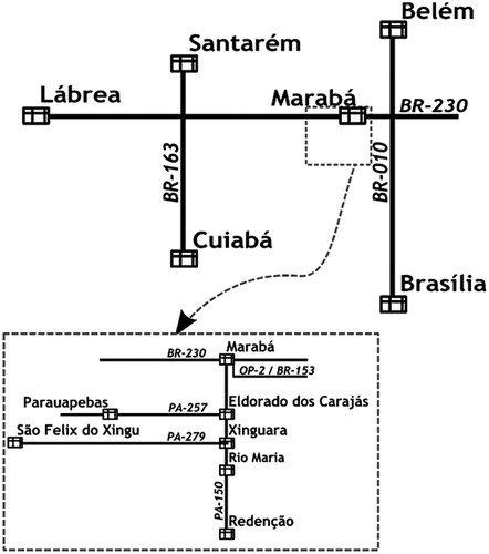
Spreading out from the one-dimensional graph of the highway system is the Cartesian template of space at ground level, the arena of land creation and the corporeal disciplines necessary to ensure that taking proceeds, that land be rendered to economy. The precipitate skeleton of the road network is imposed on two giant counties that occupy nearly the whole of southeastern Pará, namely, Marabá and Conceição do Araguaia, ruled by a handful of wealthy families from the region, including the long-resident oligarchs of the castanhais (; Emmi Citation1988; Schmink and Wood Citation1992). The municipal structure began to change with the completion of PA-150 and its necklace of urban nodes, many of which came under the control of newly arrived takers, typically ranchers from the south. The decentralization of local power intensified with Brazil’s 1988 Constitution, which promoted political devolution and the funneling of tax revenues from states directly to counties (Simmons Citation2004). As depicted in , Marabá and Conceição do Araguaia separated into twenty-eight counties by 2002, a spatial circumstance that fortified resident takers in their engagement with the camponês.
Figure 5 Cartographic discipline–power devolution.
Corporeal Discipline
Cartographic discipline involves the imposition of geometry to build a basin-scale grid, together with nested road networks and decentralized local government. It is an artifact of technology and engineering. In contrast, corporeal discipline consists mostly of violent performances deployed by takers in over a century of conflict involving the expansion of Brazil’s agricultural frontier (Foweraker Citation1981; Martins Citation1981). For the BNF, a notable instance arose when the PC do B infiltrated the region, sparking a military response and the Guerrilla War of Araguaia (). Suppression and extirpation of incipient revolution complied with President/General Medici’s order that none of the PC do B insurgents leave alive.18 The order manifested with decapitations and the public display of corpses, torture, internment in concentration camps, and burning of expired Maoist bodies, with concealment of their charred remains in secret graves (Cabral Citation1993; Inter-American Commission on Human Rights Citation1998; Portela and Neto Citation2002; Morais and Silva Citation2005; Studart Citation2006; Morais Citation2008). The military also subjected camponês sympathizers to the same murderous treatment. That 10,000 to 20,000 Brazilian soldiers were mobilized to hunt down about seventy insurgents reflects a discipline intent on spreading terror (Martins Citation1981) but terror meant to further the interests of the state and taker by producing camponês docility in the form of absence, either voluntary (outmigration, property abandonment) or involuntary (death, significant bodily harm).
Table 1. Military corporeal discipline
As the Army withdrew in the mid-1980s, the takers had to forge their own devices, rediscovering that land creation requires an indulgence of the body of the camponês (Foweraker Citation1981). The central task was to precipitate camponês absence, either by voluntary exit or otherwise. Although camponês insurgents can make takers fearful, casualty counts show takers to be more successful in their violent quest (Simmons Citation2004). As shows, the lion’s share of deaths accrued to the camponês, with 309 fatalities. This compares to only seven for takers, although their ranch hands were caught in the crossfire (sixty-four fatalities). Hired gunmen and gold miners also suffer corporeal consequences of conflict in the 1980s.
Table 2. Victims of corporeal discipline by takers, Pará State, 1980–1992
To further develop the docility of the camponês, takers sought to stymie inspirational displays that stimulate resistance, best achieved by the dissipation of camponês leadership through assassination. Targeted killings require both preparation and luck, as would-be victims know the risks they run in fronting the hungers of the poor. Nevertheless, these became sufficiently common that contract prices, by importance of target, were generally known to both gunmen and the public. reproduces a price list from the Brazilian magazine ISTOÉ (1993), in which killing a camponês is seen to be much cheaper than killing a bishop or politician. The publication of lists of individuals marked for death (e.g., Xinguara List) provides another tactic, one with significant economy given that fear might do a bullet’s work, creating the absence of death at little to no cost as camponês leaders grow fearful and silence their own vocal provocations (Inter-American Commission on Human Rights Citation1998).
Table 3. Price list for assassinations in U.S. dollars, 2006
Assassinations removed many camponês leaders. They began with the military regime in efforts to suppress the formation of rural syndicates in Conceição do Araguaia. They spread with the rebirth of democracy as takers organized a cadre of professional pistoleiros (hitmen) and created their own organization, the Uniaõ Democratica Ruralista (UDR), to defend private property rights against the aggressive pursuits of DALR (Foucault Citation1977; Schmink and Wood Citation1992; Fernandes Citation1999; Medeiros Citation2002). Killing the leadership did not always achieve limpeza, the “cleaning away” of camponês bodies, once no longer needed for land creation or labor power. Such bodies might remain “in place” given remoteness of location or immobility due to lack of labor-market opportunities and migration costs. If their immediate absence proves crucial to the taker, the disciplinary mode of choice becomes mass murder, the killing of family units or proximate collections of like-minded individuals (Andrade Citation1997; Sauer Citation2005). Such a response produces not only localized absence but spillover effects that spread by the propaganda of the deed. The tally of mass murders was high in the BNF and hinterland; indicates ten separate incidents between 1981 and 1986 in the BNP region, with a tally of 100 deaths. Although generally committed in secretive settings, this need not be. The gunning down of nineteen land reform activists in Eldorado dos Carajás, on 17 April 1996, took place in broad daylight on a well-traveled road (PA-150), with 2,000 onlookers and media presence (Simmons et al. Citation2007).
Table 4. Mass murders in the Brazil Nut Polygon
Corporeal Blandishment
Although violence represents the dominant mode of corporeal discipline deployed by takers in the BNF and other conflict areas of the lower basin, the state has offered corporeal blandishments, perhaps recognizing that economies function most efficiently when agents outside the reward circuits of the economic system nevertheless have reason to believe in its benign intent (Foucault Citation1977; Schmink and Wood Citation1992). A prime source of blandishment came in 1970 when the militarists created the Instituto Nacional de Colonização e Reforma Agrária (National Institute for Colonization and Agrarian Reform [INCRA] n.d.), tasked with colonization and agrarian reform throughout the country.
During the military era, state-led colonization in Amazonia served the dual purposes of populating the nation’s insecure borders to the north and alleviating populist demands for politically complicated land reform in other parts of the country. INCRA soon focused on Pará state, given the conflict between camponês and taker throughout the lower basin. In addition, President Médici (1969–1973) strengthened the Fundo de Assistência e Previdência ao Trabalhador Rural (Fund for Rural Worker Assistance and Welfare; FUNRURAL), a support system for elderly camponês depreciated by years spent unwittingly creating land for takers. The rural syndicates, created under Vargas as a partial answer to the threat of long-simmering peasant unrest, were also resuscitated to dilute radical discourses and provide medical investment in healthy bodies essential to labor-market participation. As the Brazilian Army decimated the PC do B, INCRA bureaucrats attempted to provide lands for those who were dispossessed by the takers.
In deeming that more needed to be done to dampen the continuing insurrectionary disposition of the camponês in the wake of the Guerrilha, the military government also created a supplemental organization, the Grupo Executivo de Trabalho do Araguaia-Tocantins (Executive Workgroup for the Araguaia-Tocantins; GETAT), tasked in 1980 with distributing land. Five years later, once the transition to democracy was underway, the new regime signaled it would pursue vigorous land reform, in effect declaring itself against the takers (Almeida Citation1991). To complete this volte-face, the government abolished INCRA, compromised by its close relationship with Brazilian armed forces during the Guerrhilha. In its place rose the Ministério da Reforma e do Desenvolvimento Agrário (Ministry of Agrarian Reform and Development; MIRAD), which initiated a wave of expropriations that stopped almost immediately with amendments to the 1988 Constitution and a generalized retrenchment of takers (Almeida Citation1991). The colluding interests of the state and corporate capital comforted takers by disciplining MIRAD and its radical approach into extinction, leaving the camponês with no vestige of institutional support.
The Emergence of Market Discipline and Demise of the BNF
As the millennium opened, neoliberal reforms spearheaded by President Cardoso in the early 1990s altered the economic landscape of Amazonia. The reduction of trade barriers, together with burgeoning demand for soybeans and beef and favorable exchange rates, stimulated agricultural development (Richards et al. Citation2016). Mato Grosso became Brazil’s prime soybean region, and the lower basin started exporting beef to domestic and global markets, particularly as the control of foot and mouth disease grew effective (Walker, Defries, et al. Citation2009). Market-based inducements to agriculture were enhanced by infrastructure investments meant to reengineer Amazonia with waterways (∼20,000 km) and an integrated road (∼100,000 km) and railway (∼10,000 km) network and to power it up with expanding hydropower capacity (i.e., Tucuruí, Belo-Monte, Rio Madeira, and Tapajós dam complexes). Simultaneously, the modalities of land creation and appropriation underwent a dramatic change via DALR and the creation of projetos de assentamento (PAs; settlement projects) for the camponês and their children. As land creation paved the way for ranching in the BNP, the forest retracted to but a mere fraction of its original extent. We now consider these interwoven processes, with a focus on the camponês, and transformations in the disciplinary regime that accompanies engagement in production chains subject to market forces.
Existential Transformations and Discipline
A critical ground-level transformation affecting social and economic processes in the BNF involves the metamorphosis of the subsistence-oriented camponês. INCRA, resurrected in 1989, plays an important role in this regard by providing institutional support for creating PAs on contested properties, following expropriations subsequent to prolonged confrontation between SMOs and takers (i.e., local oligarchs) who have remained in physical possession of the land and remnant castanhais. Such expropriations appear as state-led grabs of takers’ land, with redistribution in the interest of social welfare. Takers, however, are compensated and suffer little; in fact, they gain much. Given that they have acquired property via primitive accumulation, indemnification represents a payout on an extremely cheap investment. Instead of expropriating the properties in accordance with the 1985 National Agrarian Reform Plan (Law 91.766), MIRAD signs deeds of purchase for fifty-three properties held as aforamentos (404,613 ha), in effect paying the oligarchs for public land that they originally leased from the state for next to nothing (Bentes, Marín, and Emmi Citation1988).
The regifting of land via PAs to the camponês enables the emergence of a new social category, the small producer, formed of the camponês, now disappearing through the biological disciplines of age, and their children, newly molded agents with a foothold in the world economy (Simmons et al. Citation2010). Violent conflict between the camponês and taker subsides as the number of PAs climbs (). For the BNP, more than two thirds of the former castanhais have been surrendered to eighty-six PAs, which accommodate about 12,700 households on more than 5,700 km2.19 This accounts for 68 percent of the original land area. Evidently, the initial land grab by the takers in the BNP underwent a secondary one, this time by the state in the name of agrarian reform designed to support a New Rural World of family farmers tied to the global economy (R. Pereira, Simmons, and Walker Citation2016).20
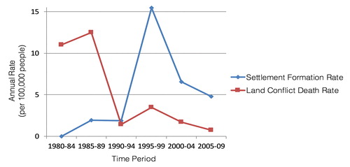
Figure 6 Land conflict mortality and settlement project formation in southeastern Pará, Brazil. Note: Settlement counts were taken from INCRA (http://www.incra.gov.br). Land conflict mortality is taken from a newspaper archive in possession of the authors (Opinião! and O Correio do Tocantins), containing 4,139 pages, with one to ten reports of land conflict violence per page. Key informants report three to fifty deaths for every one reported, in which case rates in the 1980s probably exceed 50 per 100,000 by a wide margin. No data are available for the period of the Guerrilla War of Araguaia. INCRA = National Institute for Colonization and Agrarian Reform.
The camponês, now embodied as a small producer, becomes a fully fledged participant in Amazonia’s agricultural sector (Hebette and Moreira Citation1997). This new identity enabled by the gift of land, however, is subject to a form of discipline arising from its functional role in global production networks. In particular, these newly minted small producers initiate the lower basin’s beef production chain as small-scale ranchers, who provide calves to their former existential foes, the takers. , based on a survey of PA households in the BNP, shows that more than 75 percent identify cattle as their main productive activity, and almost all of them profit from selling calves to local ranchers (Simmons et al. Citation2010; R. Pereira, Simmons, and Walker Citation2016). In fact, on the PA known as 17 de Abril formed from the expropriated lands of Fazenda Macaxeira—conflict over which led to the Eldorado dos Carajas massacre in 1996—more than two thirds of the residents now engage in market exchanges with former takers.
Table 5. Camponês households and the global meat production chain
In turn, the takers of the BNF have also undergone transformation, from mercantile capitalists to independently minded fazendeiros and finally to owners of specialized operations that buy calves, fatten them, and sell finished animals to meat-packing plants. The position of small producers at the point of origin of the source materials exposes them to climatic risk, and their numbers relative to those of the former takers mean that they face monopsonistic pricing for their calves. Further, the former takers impose contract arrangements (formal and informal) and exploit opportunities for debt peonage by advancing resources to calf suppliers, both in-kind and financial. This is not the freedom dream articulated by Padre Cicero that inspired in-migration to the region in the early twentieth century. Rather, it is the invocation of new discipline shaped by market forces and supply chain regulation that conceals the imposition of a meat grab in the region (Schneider Citation2014). Land appropriation based on force in the early phases of Amazonian development has given way to new modes of exploitation based on markets.
The Cattle Economy
At the opening of the lower Amazon Basin by the military regime, when land creation began in earnest, the cattle herd numbered about 100,000 (Silva Citation2007). This has expanded to 8.6 million animals (Walker, Browder, et al. Citation2009), reflecting explosive growth spurred by policies correcting for the military government’s mismanagement of the Brazilian economy (Barnett Citation2005; Mollo and Saad-Filho Citation2006; Weyland Citation2008).21 Macroeconomic reforms under the discursive banner of neoliberalism and the convenient disaster of “mad-cow” disease in Europe opened the floodgates for Brazilian and Amazonian export (Walker, Browder, et al. Citation2009), bringing global market forces to bear on the Amazonian forest (Walker Citation2014). The lower basin’s comparative advantage based on nearness to the raw material (cattle)—together with the weight-reducing nature of beef production—stimulated the influx of private investment. Ten highly capitalized slaughterhouses now operate in the BNF and its hinterland, sending protein from the former BNF to Asia, the Middle East, and Europe (Arima, Barreto, and Brito Citation2006; Walker, Browder, et al. Citation2009).22 Global capital is heavily committed to the BNF region and southeastern Pará State, and the Brazilian Company JBS, the world’s largest meat-processing corporation, headquartered in Sao Paulo, possesses five of the region’s slaughterhouses.23
The Disappearance of the BNF
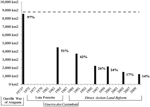
The lower basin’s cattle economy has necessitated widespread forest loss, the logical consequence of land creation, which in the BNF involves both agronomic decisions about land use and contentious acts aimed at land possession. Such acts include taker aggression and camponês resistance, including the use of fire as a weapon, preemptive liquidation of hardwoods, and excessive claims-staking by deforestation (Schmink Citation1984; Homma et al. Citation2000; Simmons et al. Citation2007; Aldrich et al. Citation2012). As the opening of the lower basin gathered momentum through the 1980s, the world capitalist system voiced a “Save the Rainforest” discourse that harmonized with calls by Brazil nut takers to protect their renewable resources (Simmons Citation2002). The military government tried to decelerate their destruction with bans on the sale of Brazil nut wood, inadvertently burned in the excitement of land creation and during battles for control of the castanhais. These measures were meant to strengthen a forestry code already requiring that proportions of all Amazonian properties be conserved under native cover. Nothing, however, stopped the material consequences of land creation, land grabbing, and land conflict, intensified by the flood of subsidies and capital that washed across the region. As shown by , much of the forest remained until the early 1970s. This changed dramatically after the defeat of the PC do B, when nearly half of the BNF vanished over the ten-year run-up to the democratic transition in 1984–1985. It was during this time that the BNF’s mercantile capitalists, benefiting from the Army’s campaign against the PC do B and sympathetic camponês, accelerated their transformation into fazendeiros, preparing themselves for the emergent cattle economy with extensive land creation in the interest of pasture formation. When democracy opened political space to camponês SMOs after 1985, contentious processes associated with DALR diminished the forest further, so that by 2009 only 14 percent of the BNF remained, nearly all the rest covered by pasture grasses ().
Figure 7 Change in total forest area, Brazil Nut Polygon. Note: Percentages are totals summed over all properties. The 1973 percentage is an estimate based on 108 (of 180) properties not obscured by clouds. Sources: Instituto Nacional de Pesquisas Espacias (Citation2011), Superintendency of Development for the Amazon (Citation1990), Tropical Rain Forest Information Center, Basic Science and Remote Sensing Initiative (Citation2007).
Conclusion
The destruction of the BNF presents a poignant ecological tragedy foreseen by all, one transpiring despite vocal and persuasive conservation rhetoric. It is thus alarming that the market economy has succeeded in two additional penetrations of Amazonia beyond the incision of BR-230 through the former BNF. One cuts northwest along the path of Rondôn’s telegraph line, itself a consolidation of trails that Portuguese and mestizo adventurers, the Bandeirantes, blazed in their eighteenth-century quest for gold and indigenous slaves through the Guaporé Valley. The telegraph line at the beginning of the twentieth century became a highway by its end, BR-364, linking Cuiabá with Porto Velho and Rio Branco, a conduit for accumulation based on 8.2 million cattle grazing where once stood forest in the states of Rondônia and Acre (Walker, Defries, et al. Citation2009). At Porto Velho, soybeans from Rondônia and Mato Grosso descend the Madeira River on barges for Itacoatiara on the main stem of the Amazon River, where they load onto deep-draft freighters serving markets overseas. Beyond Porto Velho and Rio Branco in Acre, BR-364 pivots west and continues to Peru, providing a new and critical link in the IIRSA plan to promote continental connectivity and accelerate South American–Asian trade (Killeen Citation2007; Dourojeanni, Barandiarán, and Dourojeanni Citation2009).
The second rupture follows the track of BR-163, also from Cuiabá but this time north. Completed in the 1970s but only now being paved, BR-163 reproduces a colonial trade route—from the Brazilian heartland to the Amazon stream course—through the Tapajós Valley and the region once known as Mundurukania for the tribe that still inhabits it, the Munduruku (Murphy Citation1960). Intersecting the east–west corridor of the Transamazon Highway at Ruropolis Presidente Médici, named for the man who ordered the extermination of the PC do B insurgents (Morais Citation2008), BR-163 forms the trunk of the fractal slash that quarters the basin with a giant cross, a north–south axis that connects the central plains with a second outlet, Santarém, once a sleepy fishing village built on the ashes of an ancient indigenous civilization but now Amazônia’s most dynamic internal node (Sweet Citation1974; Becker Citation1982); its $20 million Cargill port dispatching soybeans to the far corners of the world; its agglomerative energies releasing deforestation impulses close to town; and in waves of backwash south through central Pará into northern Mato Grosso (Consultoria, Planejamento e Estudos Ambientais [CPEA] Citation2010).
Capitalist interests have penetrated the basin via each of three entry points provided by spatio-history, thereby enabling a pincher movement of the agents of profit maximization in search of fungible margins of all of the vagabond beneficiaries of land creation (Becker Citation1982). The arc of deforestation—a spatial metaphor for Amazonian forest loss as it presently manifests in a crescent of fields and pastures along the basin to the south and east—is in fact a noose, given the cartographic discipline of the IIRSA plan, which calls for waterways and hydropower on every right bank tributary of the Amazon River and a string of ports servicing deep-water trade between Belém and Manaus. Although deforestation and the land creation impulse that propels it might be mitigated in the short run for any number of reasons, demand projections for Amazonian commodities forecast a significant upsurge in pressure to clear a large part of the remaining forest (Walker, Defries, et al. Citation2009; Lapola et al. Citation2010).
It is on this stage that Brazil now flexes its production might and pursues efforts aimed at the agricultural and industrial development of Amazonia. These efforts, however, carry seeds of destruction given Amazonia’s native ecosystems sustain a hydrologic cycle whose disruption—possible if deforestation exceeds an amount referred to as its “tipping point”—would desiccate much of South America and bring telecoupled impacts to the Mississippi Valley in the United States (Oyama and Nobre Citation2003; Avissar and Werth Citation2005).24 Should the infrastructure initiatives presently prosecuted under the Council of Infrastructure and Planning (COSIPLAN) and its member states set in motion the forces of land creation again, a dry Amazonia will undo the best laid plans and profits of those who sought to modernize the region, once and for all.
Global initiatives like the United Nations Program on Reducing Emissions from Deforestation and Forest Degradation (UN-REDD) and the Paris Accord have revitalized the rhetoric of sustainable development and conservation, both in Brazil and in the global community.25 It is difficult to see how such rhetoric squares with the reality of COSIPLAN’s high modernist design for Amazonia and erosion of key elements of environmental policy, particularly in Brazil. Should we believe the rhetoric or brace for the reality of what lies ahead should the IIRSA vision be fully implemented? Fortunately, we need not answer the question to draw a definitive conclusion, which is that the potential for a tipping-point catastrophe illuminates what rhetoric cannot conceal, that land creation unleashed on the forests of the middle and upper Amazon basin will destroy the agricultural economy it was meant to enable, a poignant ecological farce.
Acknowledgments
The authors acknowledge the helpful suggestions of the reviewers and editor and thank them for their assistance. They are especially indebted to Pedro Mourão for providing the cadastral map for the Brazil Nut Polygon. They are also grateful to colleagues at Embrapa-CPATU who participated in field excursions to the region in 1991 and to the many campônes households, more than 1,000, who gave generously of their time over the years to help us understand land conflict, agrarian reform, and livelihood systems in the development frontier of Amazonia.
Additional information
Funding
Notes on contributors
Cynthia S. Simmons
CYNTHIA S. SIMMONS is an Associate Professor in the Department of Geography at the University of Florida, Gainesville, FL, 32611. E-mail: [email protected]. Her research focuses on development and environment policy contradictions, including agrarian reform and land conflict, large-scale infrastructure development, and conservation in Amazonia.
Robert Walker
ROBERT WALKER is a Professor of Geography in the Center for Latin American Studies and Department of Geography at the University of Florida, Gainesville, FL 32611. E-mail: [email protected]. His research integrates remote sensing, spatial statistics, and ethnographic field data into studies of land cover change processes.
Stephen Aldrich
STEPHEN ALDRICH is an Associate Professor in the Department of Earth and Environmental Systems at Indiana State University, Terre Haute, IN 47809. E-mail: [email protected]. His research interests include conflict and environmental change, spatial techniques, and land change.
Eugenio Arima
EUGENIO ARIMA is an Associate Professor in the Department of Geography and the Environment at the University of Texas at Austin, TX 78712. E-mail: [email protected]. He is interested in understanding the drivers of tropical and Andean landscape change and how that manifests spatially in terms of patterns.
Ritaumaria Pereira
RITAUMARIA PEREIRA is an Environmental Analyst at the Amazon Institute of People and the Environment (IMAZON), Belém, Pará 66055-200, Brazil. E-mail: [email protected]. Her research examines deforestation, livestock, settlements, and regional development in the Brazilian Amazon.
Edna Maria Ramos de Castro
EDNA MARIA RAMOS DE CASTRO is a Professor in the Núcleo de Altos Estudos Amazônicos (Center for Advanced Studies of Amazonia) at the Federal University of Pará, Belém, Pará 66075-750, Brazil. E-mail: [email protected]. Her research interest is in economic development policies in Amazonia, environmental implications, and impacts on traditional populations and family farmers.
Fernando Michelotti
FERNANDO MICHELLOTTI is a Professor in the Instituto de Estudos em Desenvolvimento Agrário e Regional (Institute for Studies on Agrarian and Regional Development) at the Federal University of South and Southeast Pará, Marabá, Pará 68500-000, Brazil. E-mail: [email protected]. His research interest is in agrarian and natural resource economics with a focus on the political economy of agrarian development.
Michael Waylen
MICHAEL WAYLEN is a Doctoral Student in the Department of Geography at the University of Florida, Gainesville, FL 32611. E-mail: [email protected]. His research interests include the political ecology of resource use and development and environment contradictions.
Aghane Antunes
AGHANE ANTUNES is a Graduate Student in the Department of Geography at the University of Florida, Gainesville, FL 32611. E-mail: [email protected]. Her research interests include nature–society interactions with a focus on economic development and environmental policy in the Brazilian Amazon.
Notes
1 Brazil has not had an Agricultural Census since 2006; therefore, the official numbers are from that period.
2 Given Amazonia’s heterogeneity and complex history, we spatially and temporally bound our analysis to the BNF, the forested portion of eastern Amazonia, and to a time period starting with the military government (1964) and ending near the present time. Our frame enables us to explicate the drivers, processes, and agents of forest loss and clarifies the populations of relevance to our discussion, specifically the camponês, taker, and state.
3 Data on deforestation rates between 2004 and 2017 are from Instituto Nacional de Pesquisas Espacias/Projeto De Estimativa De Desflorestamento Da Amazônia (INPE Citation2012).
4 Although Brazilian policy has been credited with deforestation declines (Nepstad et al. 2013), key elements of the environmental policy portfolio have eroded in recent years, specifically the maintenance of protected areas, some of which are being downsized (Laue and Arima Citation2016).
5 The infrastructure program includes both (1) IIRSA, adopted in 2000 and later subsumed within COSIPLAN of the United Nations of South America (UNASUR) in 2009 (COSIPLAN 2009), and (2) independent projects of the Amazonian nations meant to complement IIRSA. The primary IIRSA objective is to transform Amazonia into a transportation hub by implementing seventy projects to create a basin-wide logistical system with 20,000 km of navigable waterways, a system of ports (about fifty new projects), a transcontinental railway with 15,000 km of rail line, and an upgrade of the ∼2 million-km road system (COSIPLAN n.d.). National hydropower projects complement IIRSA by transforming wild rivers into navigable waterways. Overall, 177 hydroelectric plants have been built or are under construction, 241 are planned, and 220 sites have been inventoried (International Rivers Citationn.d.). Although Argentina, Brazil, Chile, Colombia, Paraguay, and Peru have recently suspended their UNASUR membership for a year due to political disagreement, there is no reason to believe that the IIRSA vision will be affected because the majority of projects are national in scope and financed by public and public–private funds sourced primarily from these six nations (Burges Citation2018).
6 We draw a distinction between a contested frontier (Schmink and Wood Citation1992) and a conjoined process interleaving social conflict and deforestation in a specific place. See Simmons et al. (Citation2007) and Aldrich et al. (2012).
7 The Brazilian Communist Party (PCB) must be distinguished from the Communist Party of Brazil (PC do B) that we discuss later in reference to the Guerrilla War of Araguaia. The PCB was a member of the Comintern (Communist International) organized by the USSR under Lenin. The PC do B broke away from the PCB and gravitated toward Maoism, and the Maoist concept of people’s war that led them to the Araguaia Valley.
8 Brazilian agrarian scholarship distinguishes a myriad of sociological labels for the rural poor, including agregados, arrendarios, bois frias, caboclos, posseiros, colonos, meeiros, foreiros, parceiros, moradores, ocupantes, sitiantes, and camponês, just a few of the terms used descriptively and analytically (Simmons Citation2004). Although camponês can be translated as peasant, we opt to retain the word camponês, given its inclusiveness of many of the labels just given.
9 We accommodate the fact that diverse bodies occupied and continue to occupy the BNF by noting that individuals possess a combinatory characteristic allowing them to form aggregations dedicated to specific interests (Foucault Citation1977, 192). We consider two aggregations, which we refer to as camponês and taker.
10 Indigenous peoples long inhabited the BNF; in fact, the BNF is an anthropogenic forest (Balée Citation1989, 1994). By the 1960s, these populations had largely disappeared due to disease and prior conflicts and to migration, particularly into the Xingu River basin. Indigenous territories continue to be invaded in other parts of the basin but not in the BNF.
11 Our use of discipline is not intended to be an application of Foucault, strictly speaking. Instead, we use Foucault as a springboard for conceptual adaptation, not to force the empirics of what we observe into a Foucauldian analog.
12 From an ecological perspective, nature is not homogenous. By contrast, the gaze of the development planner construes it as such, excepting extreme features of the landscape such as mountain ranges. The point here is that cartographic discipline imposes a figurative grid (Blomley Citation2003) where none existed.
13 Corporeal violence is not an important mode of power application in the modern state. It remains, however, a potential weapon, hidden and bureaucratized, that can be deployed in the name of progress and security (Evans Citation2010).
14 The Amazonian development quest has deep historical roots in Brazil early in the twentieth century (e.g., the March to the West of President Vargas in the 1940s).
15 Only two of the 180 properties in the BNP in 1990 were owned by external corporate interests from the south, whereas the vast majority remained in the possession of the original Brazil nut oligarchs (authors’ unpublished data).
16 Brazil’s forest code outlaws the cutting, burning, and selling of Brazil nut wood (Codigo Forestal, Lei 4.771, 15/9/1965; Portaria 2.570 de IBDF [Forest Code, Law 4.771, 15 September 1965, Ordinance 2.570 of the Brazilian Institute of Forestry Development]; Machado Citation1995).
17 This action is reminiscent of primitive accumulation in England during the reformation, when church lands were in effect “nationalized.”
18 Early accounts of the Guerrilla War of Araguaia come from biographies of ex-military officers, many cited in this article. In 2012 Brazil established a National Truth Commission (CNV), which released a final report in 2014 accusing 377 individuals of state-sanctioned human rights violations between 1961 and 1988, all shielded from prosecution by the 1979 Amnesty Law. Nevertheless, official reports, videos, and documents publicly available on the CNV Web site detail military strategy and involvement at the highest level of command (President Medici), the location of torture chambers and methods, as well as names of those murdered and disappeared, with victims among the camponês (hundreds of fatalities) and the PC do B militants (CNV 2014).
19 This material is from the authors’ unpublished data.
20 In 1997, in response to growing DALR and violent land conflict, INCRA under President F. H. Cardoso announced Novo Mundo Rural (New Rural World), which was intended to provide land and to help small farmers engage with market-oriented production in accordance with the neoliberal development paradigm.
21 The herd for the entire Brazilian Amazon region now stands at 75 million.
22 The expansion of meat-processing capacity in southeastern Pará has come quickly, from next to nothing in 2000 to fourteen modern facilities by 2014, capable of processing from 500 to 1,200 animals per day (authors’ unpublished data).
23 The Brazilian Company JBS is the world’s largest meat-processing corporation. Its record of corporate buyouts includes Swift & Company in 2007, Smithfield Foods in 2008, Pilgrim’s Pride in 2009, and Plumrose in 2017. These were all formerly U.S. companies.
24 Climatologists suggest that 40 percent clearance could induce systemic changes in the vegetation (Salazar, Nobre, and Oyama 2007; Nobre and Borma 2009).
25 A prime example is the new Global Assessment on Biodiversity and Ecosystem Services, commissioned by the Intergovernmental Science-Policy Platform on Biodiversity and Ecosystem Services (IPBES), which comprises a three-year multidisciplinary collaboration of international experts. The IPBES mandate is to measure progress toward implementing the (1) Strategic Plan for Biodiversity of the United Nations Convention on Biological Diversity (the Aichi Biodiversity Targets, 2011–2020) and (2) UN’s Sustainable Development Goals, as agreed to by 193 United Nations member nations in September 2015 (IPBES Citation2016).
References
- Aldrich, S., R. Walker, C. Simmons, M. Caldas, and S. Perz. 2012. Contentious land change in the Amazon’s arc of deforestation. Annals of the Association of American Geographers 102 (1):103–28.
- Almeida, A. W. B. D. 1991. O intransitive da transição: O estado, os conflitos agrários e a violência na Amazónia (1965–1989) [The intransitivity of transition: State, agrarian conflicts and violence in Amazonia (1965–1989)]. In Amazónia: A fronteira agrícola 20 anos depois, 259–90. Belém, Brazil: Museu Paraense Emílio Goeldi.
- Almeida, A. W. B. D. 1994. Carajás: A guerra dos mapas [Carajas: A war of the maps]. Belém, Brazil: Falangolia.
- Americas Watch. 1991. Rural violence in Brazil. New York: Human Rights Watch.
- Andrade, M. P. 1997. Chacinas e massacres no campo [Slaughters and massacres in the countryside]. Master’s thesis, Federal University of Maranhao.
- Araujo, R., E. Castro, G. Rocha, M. Sa, A. Mathis, M. Monteiro, C. Puty, R. Monteiro, O. Canto, and J. Bennatti. 2008. Estado e sociedade na BR 163: desmatamento, conflitos e processos de ordenamento territorial [State and society in BR 163: Deforestation, conflicts and territorial planning processes]. In Sociedade, território e conflitos: BR-163 em questão, 13–83. Belém, Brazil: NAEA.
- Arima, E., P. Barreto, and M. Brito. 2006. Cattle ranching in the Amazon: Trends and implications for environmental conservation. Belém, Brazil: Imazon.
- Arima, E. Y., R. T. Walker, M. Sales, C. Souza, Jr., and S. G. Perz. 2008. The fragmentation of space in the Amazon basin: Emergent road networks. Photogrammetric Engineering & Remote Sensing 74 (6):699–709.
- Arima, E. Y., R. T. Walker, C. Souza, R. Pereira, and O. do Canto. 2013. Spontaneous colonization and Forest fragmentation in the Central Amazon basin. Annals of the Association of American Geographers 103 (6):1485–1501.
- Avissar, R., and D. Werth. 2005. Global climatological teleconnections resulting from tropical deforestation. Journal of Hydrometeorology 6 (2):134–45.
- Baglioni, E., and P. Gibbon. 2013. Land grabbing, large- and small-scale farming: What can evidence and policy from 20th century Africa contribute to the debate? Third World Quarterly 34 (9):1558–81.
- Balée, W. 1989. The culture of Amazonian forests. Advances in Economic Botany 7 (1):E21.
- Balée, W. 1994. Footprints of the forest: Ka’apor ethnobotany—The historical ecology of plant utilization by an Amazonian people. New York: Columbia University Press.
- Barata, R. 1995. Inventario da violência: Crime e impunidade no campo Paraense [Inventory of violence: Crime and impunity in the Paraense countryside]. Belém, Brazil: Cejup.
- Barnett, C. 2005. The consolations of neoliberalism. Geoforum 36 (1):7–12.
- Becker, B. 1982. Geopolítica da Amazónia: A nova fronteira de recursos [Amazonian geopolitics: A new resource frontier]. Rio de Janeiro, Brazil: Zahar Editores.
- Belyea, B. 1992. Images of power: Derrida/Foucault/Harley. Cartographica: The International Journal for Geographic Information and Geovisualization 29 (2):1. Accessed April 12, 2018. https://www.utpjournals.press/doi/abs/10.3138/81V4-7552-8P01-83Q1.
- Bentes, R. D. S., R. A. Marín, and M. F. Emmi. 1988. Os cemitérios das castanheiras do Tocantins [The cemeteries of the Brazil nut trees of Tocantins]. Pará Desenvolvimento 23 (1):18–23.
- Blomley, N. 2003. Law, property, and the geography of violence: The frontier, the survey, the grid. Annals of the Association of American Geographers 93 (1):121–41.
- Borras, S. M., J. C. Franco, S. Gómez, C. Kay, and M. Spoor. 2012. Land grabbing in Latin America and the Caribbean. The Journal of Peasant Studies 39 (3–4):845–72.
- Brazilian Institute of Geography and Economy (IBGE). 2006. Agricultural census. Brasilia: IBGE.
- Brondızio, E., S. McCracken, E. F. Moran, A. D. Siqueira, D. Nelson, and C. Rodriguez-Pedraza. 2002. The colonist footprint: Towards a conceptual framework of deforestation trajectories among small farmers in frontier Amazonia. Deforestation and land use in the Amazon. Gainesville: University of Florida Press.
- Browder, J. 1988. Public policies and deforestation in the Brazilian Amazon. In Public policies and the misuse of Forest resources, ed. R. Repetto and M. Gillis, 247–98. Cambridge, UK: Cambridge University Press.
- Browder, J. O., M. A. Pedlowski, R. Walker, R. H. Wynne, P. M. Summers, A. Abad, N. Becerra-Cordoba, and J. Mil-Homens. 2008. Revisiting theories of frontier expansion in the Brazilian Amazon: A survey of the colonist farming population in Rondônia’s post-Frontier, 1992–2002. World Development 36 (8):1469–92.
- Bunker, S. G. 1982. The cost of modernity: Inappropriate bureaucracy, inequality, and development program failure in the Brazilian Amazon. The Journal of Developing Areas 16 (4):573–96.
- Burges, S. 2018. UNASUR’s dangerous decline: The risks of a growing left–right split in South America. Accessed May 14, 2018. http://www.americasquarterly.org/content/unasurs-dangerous-decline-risks-growing-left-right-split-south-america#.Wu8EPSYzCSA.twitter.
- Cabral, P. 1993. Xambioá: Guerrilha no Araguaia (novela baseada em fatos reais) [Xambioá: Guerrilla war in the Araguaia]. Belém, Brazil: Graphitte Editores.
- Caldas, M., R. Walker, E. Arima, S. Perz, S. Aldrich, and C. Simmons. 2007. Theorizing land cover and land use change: The peasant economy of Amazonian deforestation. Annals of the Association of American Geographers 97 (1):86–110.
- Cardoso, F. H., and G. Muller. 1977. Amazônia: Expansão do capitalismo [Amazonia: Expansion of capitalism]. Sao Paulo, Brazil: Editora Basiliense.
- CNV (Brazil’s National Truth Commission). 2014. Final Report: Documents on Guerrilla War of Araguaia. Center of Memories Revealed at the National Archive in Brazil. Accessed September 5, 2017. http://www.cnv.gov.br/todos-volume-1/658-documentos-sobre-a-guerrilha-do-araguaia.html.
- Consultoria, Planejamento e Estudos Ambientais (CPEA). 2010. RIMA: Environmental impact report. Sao Paulo, Brazil: Grafica NEOBAND.
- Cotula, L. 2012. The international political economy of the global land rush: A critical appraisal of trends, scale, geography and drivers. The Journal of Peasant Studies 39 (3–4):649–80.
- Council of Infrastructure and Planning (COSIPLAN). 2009. Estatuto Consejo de Infraestructura y Planeamiento [Council on Infrastructure and Planning Statute]. Accessed May 14, 2018. http://www.unasursg.org/images/descargas/ESTATUTOS%20CONSEJOS%20MINISTERIALES%20SECTORIALES/ESTATUTO%20CONSEJO%20DE%20INFRAESTRUCTURA%20Y%20PLANEAMIENTO.pdf.
- COSIPLAN. n.d. Amazonas infographic. Accessed May 14, 2018. http://www.iirsa.org/infographic#ama.
- Crampton, J. W. 2003. Cartographic rationality and the politics of geosurveillance and security. Cartography and Geographic Information Science 30 (2):135–48.
- Crouzeilles, R., R. Feltran-Barbieri, M. S. Ferreira, and B. B. N. Strassburg. 2017. Hard times for the Brazilian environment. Nature Ecology & Evolution 1 (9):1213.
- Dourojeanni, M., A. Barandiarán, and D. Dourojeanni. 2009. Amazonía peruana en 2021: Explotación de recursos naturales e infraestructuras:? Qué está pasando? Qué es lo que significan para el futuro? [Peruvian Amazon in 2021: Exploitation of natural resources and infrastructures: What is happening? What do they mean for the future?]. Fundación Peruana para la Conservación de la Naturaleza. La Paz, Bolivia: La Plataforma Energetica, promoted by the Center for Studies on Labor and Agrarian Development. Accessed March 10, 2018. http://www.plataformaenergetica.org/sites/default/files/Amazoniaperuanaen2021.pdf.
- Edelman, M., and A. León. 2013. Cycles of land grabbing in Central America: An argument for history and a case study in the Bajo Aguán, Honduras. Third World Quarterly 34 (9):1697–1722.
- Edelman, M., C. Oya, and S. M. Borras. 2013. Global land grabs: Historical processes, theoretical and methodological implications and current trajectories. Third World Quarterly 34 (9):1517–31.
- Emmi, M. F. 1988. A oligarquia do Tocantins e o domínio dos castanhais [The oligarchy of Tocantins and the domain of the Brazil nuts]. Belem, Brazil: Federal University of Pará and Núcleo de Altos Estudos Amazônicos.
- Evans, B. 2010. Foucault’s legacy: Security, war and violence in the 21st century. Security Dialogue 41 (4):413–33.
- Fernandes, M. 1999. Donos de terras: Trajetórias da União Democrática Ruralistas (UDR) [Land owners: Trajectory of the Rural Democratic Union]. Belém, Brazil: UFPA/NAEA.
- Foresta, R. A. 1991. Amazon conservation in the age of development: The limits of providence. Gainesville: University of Florida Press.
- Foresta, R. A. 1992. Amazonia and the politics of geopolitics. Geographical Review 82 (2):128–42.
- Foucault, M. 1977. Discipline and punish: The birth of the prison. New York: Vintage.
- Foweraker, J. 1981. The struggle for land: A political economy of the pioneer frontier in Brazil. Cambridge, UK: Cambridge University Press.
- García-Barrios, L., Y. M. Galván-Miyoshi, I. A. Valsieso-Pérez, O. R. Masera, G. Bocco, and J. Vandermeer. 2009. Neotropical forest conservation, agricultural intensification, and rural out-migration: The Mexican experience. BioScience 59 (10):863–73.
- Gomes, C. V. A., J. M. Vadjunec, and S. G. Perz. 2012. Rubber tapper identities: Political–economic dynamics, livelihood shifts, and environmental implications in a changing Amazon. Geoforum 43 (2):260–71.
- Hall, A. 1987. Agrarian crisis in Brazilian Amazonia: The Grande Carajas programme. Journal of Development Studies 23 (4):522–52.
- Hall, R., M. Edelman, S. M. Borras, Jr., I. Scoones, B. White, and W. Wolford. 2015. Resistance, acquiescence or incorporation? An introduction to land grabbing and political reactions from below. Journal of Peasant Studies 42 (3–4):467–88.
- Harley, J. B. 1988. Silences and secrecy: The hidden agenda of cartography in early modern Europe. Imago Mundi 40 (1):57–76.
- Harvey, D. 2001. Globalization and the spatial fix. Geographische Revue 2:23–30.
- Hebette, J., and R. E. Marin. 2004. A Ligação Rodoviária Norte-Sul: Sonhos e Realidade [The North–South road link: Dreams and reality]. In Cruzando e fronteira: 30 ano de estudo campesinato na amazônia, 36–38. Belem, Brazil: UFPA.
- Hebette, J., and E. Moreira. 1997. A marcha do trabalhador do campo rumo a cidadania: Dominio da terra e estrutura social no Para [The march of the rural worker towards citizenship: Land domination and social structure in Para]. São Paulo Em Perspetiva 11 (2):119–27.
- Hecht, S. B. 1985. Environment, development and politics: Capital accumulation and the livestock sector in eastern Amazonia. World Development 13 (6):663–84.
- Hecht, S. B. 2013. The scramble for the Amazon and the “lost paradise” of Euclides da Cunha. Chicago: University of Chicago Press.
- Hecht, S. B. 2014. Forests lost and found in tropical Latin America: The woodland “green revolution.” The Journal of Peasant Studies 41 (5):877–909.
- Hecht, S. B., and A. Cockburn. 1989. The fate of the forest: Developers, destroyers, and defenders of the Amazon. Chicago: University of Chicago Press.
- Homma, A. K. O. 2001. As políticas públicas como indutora da “morte anunciada” dos castanhais no Sudeste Paraense [Public policies as an inducer of the “announced death” of Brazilnut trees in southeast Pará]. In Embrapa Amazônia Oriental-Artigo em anais de congresso (ALICE), 4. Belém, PA, Brazil: Sociedade Brasileira de Economia Ecológica.
- Homma, A. K. O., R. Carvalho, C. A. Ferreia, and J. D. N. Nascimento. 2000. A destruição de recursos naturais: O caso da castanha-do-para no Sudeste Paraense [The destruction of natural resources: The case of Brazil nut in the southeast of Para. Documentos (INFOTECA-E) 32, Embrapa Amazônia Oriental, Belém, Brasil.
- Ianni, O. 1979. Colonização e contra-reforma na Amazónia [Colonization and contra-agrarian reform in Amazonia]. Petrópolis, RJ, Brazil: Vozes.
- Instituto Nacional de Pesquisas Espacias (INPE). 2011. Projeto PRODES—Monitoramento da Floresta Amazônica Brasileira por Satélite [PRODES Project—Monitoring the Brazilian Amazon forest by satellite]. Accessed June 19, 2012. http://www.obt.inpe.br/prodes/.
- INPE. 2012. Projeto PRODES—Monitoramento da floresta Amazónica Brasileira por satélite [Satellite monitoring of the Brazilian Amazon forest]. Accessed April 1, 2018. http://www.obt.inpe.br/OBT/assuntos/programas/amazonia/prodes.
- Inter-American Commission on Human Rights. 1998. Report No. 33/97, CASE11.405, Brazil. Accessed March 24, 2011. http://www.cidh.org/annualrep/97eng/Brazil11405.htm.
- Intergovernmental Science-Policy Platform on Biodiversity and Ecosystem Services (IPBES). 2016. Press release: IPBES launches new assessment of biodiversity and ecosystem services. Accessed February 15, 2018. https://www.ipbes.net/article/press-release-ipbes-launches-new-assessment-biodiversity-and-ecosystem-services.
- International Rivers. n.d. The state of the world’s rivers. Accessed October 5, 2017. http://tryse.net/googleearth/irivers-dev3/.
- Jackson, J. 2008. The thief at the end of the world: Rubber, power, and the seeds of empire. London: Penguin.
- Jessop, B. 2006. Spatial fixes, temporal fixes, and spatio-temporal fixes. In David Harvey: A critical reader, ed. N. Castree and D. Gregory, 142–66. Malden, MA: Blackwell.
- Killeen, T. J. 2007. A perfect storm in the Amazon wilderness: Development and conservation in the context of the Initiative for the Integration of the Regional Infrastructure of South America (IIRSA). Arlington, VA: Conservation International.
- Kitamura, P. C., and C. Muller. 1984. Castanhais nativos de Marabá, PA: Fatores de depredação e bases Para a sua preservação [Native Brazil nut trees of Maraba, Pa: Depredation factors and basis for their preservation]. Belém, Brazil: EMBRAPA.
- Kotscho, R. 1981. O massacre dos posseiros: Conflitos de terras no Araguaia-Tocantins [The massacre of squatters: Land conflicts in Araguaia-Tocantins]. São Paulo, Brazil: Editora Brasiliense.
- Lapola, D. M., R. Schaldach, J. Alcamo, A. Bondeau, J. Koch, C. Koelking, and J. A. Priess. 2010. Indirect land-use changes can overcome carbon saving from biofuels in Brazil. Proceedings of the National Academy of Sciences 107 (8):3388–93.
- Laue, J. E., and E. Arima. 2016. What drives downsizing of protected areas? A case study of Amazon National Park. Journal of Latin American Geography 15 (2):7–31.
- Machado, P. A. L. 1995. Direito Ambiental Brasileiro. [Brazilian environmental laws]. 5th ed. São Paulo, Brazil: Malheiros Editores Ltda.
- Mahar, D. J. 1979. Frontier development policy in Brazil: A study of Amazonia. New York: Praeger.
- Marques, M., C. Paes, and F. Cristini. 2018. Memorando da CIA reforça que imagem de “moderado” de Geisel era falsa, dizem historiadores [CIA Memorandum reinforces that Geisel’s “moderate” image was false, say historians]. G1. Accessed May 15, 2018. https://g1.globo.com/politica/noticia/memorando-da-cia-reforca-que-imagem-de-moderado-de-geisel-era-falsa-dizem-historiadores.ghtml.
- Martins, J. S. 1981. Os camponeses e a politica no Brasil: As lutas sociais no campo e seu lugar no processo politico [The peasants and politics in Brazil: The social struggles in the countryside and their place in the political process]. Petropolis, Brazil: Vozes.
- McMichael, P. 2005. Global development and the corporate food regime. Research in Rural Sociology and Development 11:269–303.
- McMichael, P. 2012. The land grab and corporate food regime restructuring. The Journal of Peasant Studies 39 (3–4):681–701.
- Medeiros, L. S. 2002. Movimentos sociais, disputas políticas e reforma agrária de mercado no Brasil [Social movements, political disputes and agrarian market reform in Brazil]. Rio de Janeiro, RJ: Federal Rural University of Rio de Janeiro/ Social Science in Agricultural and Social Development.
- Mollo, M. D. L. R., and A. Saad-Filho. 2006. Neoliberal economic policies in Brazil (1994–2005): Cardoso, Lula and the need for a democratic alternative. New Political Economy 11 (1):99–123.
- Morais, T. 2008. Sem vestígios: Revelações de um agente secreto da ditadura militares Brasileira [Without trace: Revelations of a secret agent of the Brazilian military dictatorship]. São Paulo, Brazil: Geração Editorial.
- Morais, T., and E. Silva. 2005. Operação Araguaia: Os arquivos secretas da guerrilha [Operation Araguaia: The secret files of the guerrilla war]. São Paulo, Brazil: Geração Editorial.
- Moran, E. 1981. Developing the Amazon. Bloomington: Indiana University Press.
- Murphy, R. F. 1960. Headhunter’s heritage: Social and economic change among the Mundurucu Indians. Berkeley: University of California Press.
- Nally, D. 2015. Governing precarious lives: Land grabs, geopolitics, and food security. The Geographical Journal 181 (4):340–49.
- National Institute of Colonization and Agrarian Reform (INCRA). n.d. O Novo INCRA. Accessed January 11, 2008. http://www.incra.gov.br/sites/default/files/uploads/servicos/publicacoes/outras-publicacoes/o_novo_incra.pdf.
- Nepstad, D. C., W. Boyd, C. Stickler, T. Bezerra, and A. A. Azevedo. 2013. Responding to climate change and the global land crisis: REDD, market tranformations and low-emissions rural development. Philosophical Transactions of the Royal Society B: Biological Sciences 368:20120167.
- Nepstad, D., McGrath, D. C. Stickler, A. Alencar, A. Azevedo, B. Swette, T. Bezerra, et al. 2014. Slowing Amazon deforestation through public policy and interventions in beef and soy supply chains. Science 344 (6188):1118–23.
- Nobre, C. A., and L. D. S. Borma. 2009. Tipping points for the Amazon Forest. Current Opinion in Environmental Sustainability 1 (1):28–36.
- Oksala, J. 2010. Violence and the biopolitics of modernity. Foucault Studies 10:23–43.
- Oliveira, A. U. 1988. A geografia das lutas sociais no campo [The geography of social struggles in the countryside]. São Paulo, Brazil: Contexto.
- Oliveira, G. 2013. Land regularization in Brazil and the global land grab. Development and Change 44 (2):261–83.
- Overbeck, G. E., H. G. Bergallo, C. E. V. Grelle, A. Akama, F. Bravo, G. R. Colli, W. E. Magnusson, W. M. Tomas, and G. W. Fernandes. 2018. Global biodiversity threatened by science budget cuts in Brazil. BioScience 68 (1):11–12.
- Oyama, M. D., and C. A. Nobre. 2003. A new climate-vegetation equilibrium state for tropical South America. Geophysical Research Letters 30 (23).
- Peluso, N. L., and C. Lund. 2011. New frontiers of land control: Introduction. Journal of Peasant Studies 38 (4):667–81.
- Pereira, L. C. O. 2006. Terra e Natureza: Assentamentos Rurais de Rio Maria (1974–2004) [Land and nature: The rural settlements of Rio Maria (1974–2004)]. MA Thesis, Belém, Brazil, UFPA.
- Pereira, R., C. S. Simmons, and R. Walker. 2016. Smallholders, agrarian reform, and globalization in the Brazilian Amazon: Cattle versus the environment. Land 5 (3):24.
- Pereira, S. L., and S. Sauer. 2011. Expansión de agronegocios, mercado de tierras y extranjerización de la propiedad rural en Brasil: Notas críticas sobre la dinámica reciente [Expansion of agribusiness, land market and foreign land exploitation in Brazil: Critical notes on recent dynamics]. Revista del CIECAS-IPN 8 (26):43–63.
- Pfaff, A., J. Robalino, R. Walker, S. Aldrich, M. Caldas, E. Reis, S. Perz, et al. 2007. Road investments, spatial spillovers, and deforestation in the Brazilian Amazon. Journal of Regional Science 47 (1):109–23.
- Portela, F., and J. G. Neto. 2002. Guerra de guerrilhas no Brasil: A saga do Araguaia [Guerrilla war in Brazil: The Araguaia saga]. São Paulo, Brazil: Editora Terceiro Nome.
- Richards, P., T. Reardon, D. Tschirley, T. Jayne, J. Oehmke, and D. Atwood. 2016. Cities and the future of agriculture and food security: A policy and programmatic roundtable. Food Security 8 (4):871–77.
- Rockwell, C. A., M. R. Guariguata, M. Menton, E. A. Quispe, J. Quaedvlieg, E. Warren-Thomas, H. F. Silva, et al. 2015. Nut production in Bertholletia excelsa across a logged forest mosaic: Implications for multiple forest use. Plos ONE 10 (8):e0135464.
- Salazar, L. F., C. A. Nobre, and M. D. Oyama. 2007. Climate change consequences on the biome distribution in tropical South America. Geophysical Research Letters 34 (9):L09708.
- Santana, A. C., J. L. Dávila, M. I. Alencar, P. N. Mattar, R. F. Souza, and R. M. Queiroz da Costa. 1997. Reestruturação produtiva e desenvolvimento na amazônia: Condicionantes e perspectivas [Productive restructuring and development in the Amazon: Constraints and perspectives]. Belém, Brazil: Banco da Amazônia.
- Sauer, S., ed. 2005. Violação dos direitos humanos na Amazônia: Conflito e violencia na fronteira paraense [Violation of human rights in the Amazon: Conflict and violence on the border of Para]. Accessed September 9, 2017. http://www.global.org.br/wp-content/uploads/2015/09/2005-Viola—-o-de-DH-na-Amazonia.pdf.
- Sawyer, D. R. 1984. Frontier expansion and retraction in Brazil. I. In Frontier expansion in Amazonia, ed. M. Schmink and C. Wood, 180–203. Gainesville: University of Florida Press.
- Schmink, M. 1984. Frontier expansion in Amazonia. Gainesville: University Press of Florida.
- Schmink, M., and C. H. Wood. 1992. Contested frontiers in Amazonia. New York: Columbia University Press.
- Schneider, M. 2014. Developing the meat grab. The Journal of Peasant Studies 41 (4):613–33.
- Scott, J. C. 1998. Seeing like a state: How certain schemes to improve the human condition have failed. New Haven, CT: Yale University Press.
- Selwyn, B. 2015. Commodity chains, creative destruction and global inequality: A class analysis. Journal of Economic Geography 15 (2):253–74.
- Shepard, G. H., and H. Ramirez. 2011. Made in Brazil: Human dispersal of the Brazil nut (Bertholletia excelsa, Lecythidaceae) in ancient Amazonia. Economic Botany 65 (1):44–65.
- Silva, F. 2007. A economia pastoril e os primórdios do capitalismo na região do araguaia paraense (1890–1960) [The pastoral economy and the primordia of the capitalism in the Araguaia region of Paraense (1890–1960)]. Novos Cadernos NAEA 10 (1):5–22.
- Simmons, C. S. 2002. The local articulation of policy conflict: Land use, environment, and Amerindian rights in Eastern Amazonia. The Professional Geographer 54 (3):241–58.
- Simmons, C. S. 2004. The political economy of land conflict in the Eastern Brazilian Amazon. Annals of the Association of American Geographers 94 (1):183–206.
- Simmons, C. S. 2005. Territorializing land conflict: Space, place, and contentious politics in the Brazilian Amazon. GeoJournal 64 (4):307–17.
- Simmons, C. S., R. T. Walker, E. Y. Arima, S. P. Aldrich, and M. M. Caldas. 2007. The Amazon land war in the south of Pará. Annals of the Association of American Geographers 97 (3):567–92.
- Simmons, C., R. Walker, S. Perz, S. Aldrich, M. Caldas, R. Pereira, F. Leite, L. C. Fernandes, and E. Arima. 2010. Doing it for themselves: Direct action land reform in the Brazilian Amazon. World Development 38 (3):429–44.
- Smalley, R., and E. Corbera. 2012. Large-scale land deals from the inside out: Findings from Kenya’s Tana Delta. The Journal of Peasant Studies 39 (3–4):1039–75.
- Smith, N. J. 1982. Rainforest corridors: The Transamazon colonization scheme. Berkeley: University of California Press.
- Smith, N. J. 1992. History and philosophy of geography: Real wars, theory wars. Progress in Human Geography 16 (2):257–71.
- Studart, H. 2006. A lei da selva: Estratégias, imaginário e discurso dos militares sobre a Guerrilha do Araguaia [The law of the jungle: Strategies, imaginary and military discourse on the Araguaia Guerrilla]. São Paulo, Brazil: Geração Editorial.
- Superintendency of Development for the Amazon (SUDAM). 1990. Perfil da ocupação do solo e subsolo Paraenses [Profile of the occupation of the soil and subsurface claims of the state of Pará]. Brasília, Brazil: Superintendency of Development for the Amazon.
- Sweet, D. G. 1974. A rich realm of nature destroyed: The Middle Amazon valley, 1640–1750. Madison: University of Wisconsin.
- Tropical Rain Forest Information Center, Basic Science and Remote Sensing Initiative, Michigan State University (TRFIC). 2007. LBA-ECO LC-10 Orthorectified Landsat ETM + data for Legal Amazon, 1999-2001 data set. Oak Ridge, TN: Oak Ridge National Laboratory Distributed Active Archive Center. http://www.daac.ornl.gov
- Veja. 1996. Brasil–Sangue em Carajás [Brazil—Blood in Carajas]. São Paulo: Editora Abril.
- Vieira, M. A. D. C. 2001. Á procura das Bandeira Verdes: Viagem, missão e romaria—Movimentos socio-religiosos na Amazônia Oriental [In search of the green flags: Voyage, mission, and pilgrimage—Socio-religious movements in the Eastern Amazon]. PhD dissertation, Universidade Estadual de Campinas, Instituto de Filosofia e Ciências Humanas.
- Virgilio, N. 2009. Noel Kempff Mercado climate action project: A case study in reducing emissions from deforestation and degradation. Washington, DC: The Nature Conservancy.
- Walker, R. 1993. Deforestation and economic development. Canadian Journal of Regional Science 16 (3):481–97.
- Walker, R. 2003. Mapping process to pattern in the landscape change of the Amazonian frontier. Annals of the Association of American Geographers 93 (2):376–98.
- Walker, R. 2014. Sparing land for nature in the Brazilian Amazon: Implications from location rent theory. Geographical Analysis 46 (1):18–36.
- Walker, R., J. Browder, E. Arima, C. Simmons, R. Pereira, M. Caldas, R. Shirota, and S. de Zen. 2009. Ranching and the new global range: Amazônia in the 21st century. Geoforum 40 (5):732–45.
- Walker, R., R. Defries, M. Del Carmen Vera-Diaz, Y. Shimabukuro, and A. Venturieri. 2009. The expansion of intensive agriculture and ranching in Brazilian Amazonia. Amazonia and Global Change 186:61–81.
- Walker, R., E. Moran, and L. Anselin. 2000. Deforestation and cattle ranching in the Brazilian Amazon: External capital and household processes. World Development 28 (4):683–99.
- Walker, R., and C. Simmons. 2018. Endangered Amazon: An indigenous tribe fights back against hydropower development in the Tapajós Valley. Environment: Science and Policy for Sustainable Development 60 (2):4–15.
- Weyland, K. 2008. Toward a new theory of institutional change. World Politics 60 (2):281–314.
- Wolford, W., S. M. Borras, R. Hall, I. Scoones, and B. White. 2013. Governing global land deals: The role of the state in the rush for land. Development and Change 44 (2):189–210.