
Abstract
This article synthesizes contributions of a growing body of geographic scholarship on marronage and presents a framework of maroon geographies to guide scholarship and political organizing centered on Black place- making and racial justice. I situate marronage-focused geographic scholarship within Black geographies literature that highlights the reverberations of transatlantic slavery in our current world order and historical and ongoing Black spatial acts of struggle and survival. Based on this scholarship and my own empirical research in Montgomery County, Maryland, I construct a framework of maroon geographies that encompasses physical sites of past flight from slavery as well as spaces produced through contemporary Black struggles. This framework comprises four main features: reworking geographic refuse, Black cooperative place- making, fugitive infrastructure, and a spatial strategy of entanglement. Maroon geographies offer a framework to explicitly address legacies of Black spatial epistemologies and practices that made possible freedom from slavery and that continue to shape sites of radical transformation and possibility. I conclude with a discussion of how the framework can inform scholarship and Black organizing.
通过综合越来越多的奴隶解放地理学研究, 本文提出了奴隶地理框架, 用于指导建立黑人领地和种族正义的学术研究和政治组织。我把奴隶解放的地理研究, 置于黑人地理文献中。这些文献, 突出了跨大西洋奴隶制在当今世界秩序中的回响、以及历史的和当今的黑人斗争和生存的空间行为。基于文献和我在美国马里兰州蒙哥马利县的实证研究, 我构建了一个奴隶地理框架, 包括历史逃离奴隶制的地点、当代黑人斗争产生的空间。这个框架包括四个主要特点:改造地理反抗、黑人合作场所、逃逸基础设施和牵连空间策略。奴隶地理提供了这样一个框架:明确讨论了黑人空间认识论和实践的影响, 包括实现从奴隶到自由的转变、持续塑造巨大转变和可能性的地点。最后讨论了该框架如何帮助学术研究和黑人组织。
Este artículo sintetiza las contribuciones de un creciente cuerpo de conocimiento geográfico sobre fuga de esclavos y presenta un marco relacionado con las geografías de esclavos fugitivos, o cimarronaje, para orientar la erudición y la organización política centrado en la construcción de lugar por el negro fugitivo y justicia racial. Yo sitúo la erudición geográfica enfocada en el cimarronaje dentro de la literatura de las geografías negras que destacan las reverberaciones de la esclavitud transatlántica en nuestro orden del mundo actual y los actos espaciales históricos y corrientes de lucha y supervivencia. Con base en esta erudición y en mi propia investigación empírica en el Condado de Montgomery, Maryland, construyo una infraestructura de las geografías del negro cimarrón que incluye los sitios físicos asociados con la fuga pasada desde la esclavitud lo mismo que los espacios producidos en las luchas negras contemporáneas. Esta estructura comprende cuatro rasgos principales: reelaboración del rechazo geográfico, construcción de lugar por acción negra cooperativa, infraestructura del fugitivo y la estrategia espacial del enredo. Las geografías del cimarrón ofrecen un marco para abocar explícitamente los legados de epistemologías y prácticas espaciales negras con las que aquél consiguió librarse de la esclavitud y que siguen configurando sitios de transformación y posibilidad radicales. Concluyo con una discusión sobre cómo aquella infraestructura o marco de referencia puede informar la erudición y la organización negras.
Palabras clave:
This article discusses the importance of geographic scholarship on the history and continued significance of marronage. Marronage—the practices of flight from enslavement and placemaking beyond slavery—took place during the sixteenth through nineteenth centuries across the Americas. Through marronage, enslaved Black people asserted their freedom, evaded slave catchers, and created communities that were physically removed from the dominant slave society. Maroon communities varied in form, ranging from small groups to large societies and from “hinterland” to “borderland” groups who respectively settled deep in the wilderness or, conversely, near farms, plantations, and cities (Diouf Citation2014). Communities of maroons also became known by names such as palenques (e.g., in Cuba and Colombia), cumbes (e.g., in Venezuela), and mocambos and quilombos in Brazil. Those who settled in maroon communities included Black people as well as Indigenous and poor White people who sought protection from White- and capitalist-dominated slave societies.
Since the abolition of transatlantic slavery, marronage has persisted at the center of place-based communal struggles against state and extralegal racial violence. As racial conditions of slavery resonate in anti-Black violence today within “the context of persistent labor exploitation, hyper-surveillance, and unending incarceration,” marronage continues to manifest in myriad forms, including “border crossing, bench-warrant avoidance, and prison abolition” (Quan Citation2017, 184). I use the term maroon geographies to name historical and ongoing spatial praxes of Black flight from and placemaking beyond racial violence that emerged during transatlantic slavery.
In this article, I discuss the growing body of geographic scholarship on marronage, outline a framework of maroon geographies that can guide future scholarship on marronage, and explain how this framework can help critical scholars and scholar activists struggle toward alternative futures centered on transformative racial justice. Building from Gilmore’s (Citation2007) definition of racism as “the state-sanctioned or extralegal production and exploitation of group-differentiated vulnerability to premature death” (28), I define transformative racial justice as the structural transformation and eradication of conditions that systematically expend and devalue some people’s lives over other racial groups. Transformative racial justice requires deep understandings of racial history alongside avowals of the alternative definitions and practices of humanity and placemaking based in Black, Indigenous, and other communities of color. Thus, my discussion of maroon geographies draws on my own empirical work in historically Black communities in Montgomery County, Maryland. Throughout the article, I offer historical examples of marronage in Montgomery County and conclude with a contemporary example to illustrate how the maroon geographies framework can be applied.
Marronage in Geography
Histories and spaces of marronage have been understudied in geography. For almost a century, scholarship on marronage has been principally concentrated amongst historians, anthropologists, and archeologists (e.g., Aptheker Citation1939, Citation1947; Price Citation1973, Citation1975, Citation1976; Leaming Citation1979; Agorsah Citation1994; Mulroy Citation2003; Leone, LaRoche, and Babiarz Citation2005; Thompson Citation2006; Diouf Citation2014; LaRoche Citation2014; Sayers Citation2014). This body of work highlights the historical significance and past cultures of maroon communities and societies. Other noteworthy scholarly contributions focus on the politics and enduring legacies of marronage, situating it within extensive and ongoing histories of Black freedom struggles (e.g., Robinson Citation2000; N. Roberts Citation2015). Following Neil Roberts’ (Citation2015) call for scholars to “reorient our epistemology of freedom around marronage” (173), marronage has gained attention in recent scholarship on, for example, queer Black placemaking (Joyce Citation2017), world building confronting the institutional order of “Euromodernity” (Lebrón Ortiz Citation2019), and “epistemological fugitivity” (Krueger-Henney and Ruglis Citation2020, 5). In this new focus, geographers have a distinct opportunity to trace marronage’s enduring impacts on and iterations in the present landscape.
Situated within theoretical advances made in the field of Black geographies, geographers increasingly examine the reverberations of transatlantic slavery in our current world order. Black geographies scholarship contends that the slave ship, the auction block, the plantation, and other slavery-era geographies are ongoing loci of anti-Black violence and death in the Americas—reproduced in the present day through policing, imprisonment, immigrant detention, uneven development, environmental racism, and other systematic racial violence (C. Woods Citation1998; McKittrick Citation2011, Citation2013; Bledsoe Citation2017; C. Woods et al. Citation2017; Wright Citation2018; Davis et al. Citation2019; Vasudevan Citation2019; A. R. Roberts Citation2020). Black geographies scholarship also acknowledges the important spatial acts of struggle and survival that exist alongside and against “historically present” geographies of Black dispossession (McKittrick Citation2006, 7). As a primary form of Black struggle against dominant geographies, Black geographies scholars point to marronage as a survival tactic enacted against “conditions of bondage … [comprising] alternative mapping practices during and after transatlantic slavery” (McKittrick Citation2011, 949). The alternative placemaking, ethics, and social visions animating marronage “became the pillars of a parallel social order” operating outside of the laws of the formal political economy both during and after slavery (C. Woods et al. Citation2017, 13).
Continuing the work of Black geographies, a growing body of geographic scholarship stretches the concept of marronage to understand racial liberation struggles both within and beyond the spatial and temporal spaces of chattel slavery in the Americas (Bledsoe Citation2016, Citation2017; Malm Citation2018; Ferretti Citation2019; Winston Citation2019; Wright Citation2019; Thomas Citation2020). Some of the contributions of this work include the delineation of a spatial politics of marronage linking historical and contemporary Black liberation struggles across urban and rural places spanning the Western hemisphere (Bledsoe Citation2017) and a grounded approach to connecting past and present Black fugitive placemaking that resists capitalism and neoliberal governance (Malm Citation2018; Thomas Citation2020). Geographic scholarship on marronage also offers an analytical lens and language for considering the inherently spatial praxes of escape from and world-building beyond racial subjugation, enclosure, and bondage. In other words, marronage must be understood not just as a fleeting practice of flight but also as a significant method of producing place. As Wright (Citation2019) contended, the conversion of difficult, unruly terrains such as swamps and mountains deemed “undesirable and inaccessible” (1138) for governance and capital accumulation made possible maroons’ “alternative social and political worlds” (1142). Underscoring the “revolutionary maroon ecology” (Malm Citation2018, 24) through which self-emancipated Black people transformed their physical worlds to create zones of liberation provides insight into long-standing Black spatial life forms and epistemologies.
Geographers’ expanding focus on marronage is especially critical in countering the presumed aspatial nature of Blackness that Black geographies scholars aim to challenge (McKittrick and Woods Citation2007; Hawthorne Citation2019). If, as Gilmore (Citation2017) contended, “freedom is a place,” then how have oppressed people produced “liberated life-ways” through the combination of “people, land, other resources, [and] social capacity” (227–28) that is placemaking? Moreover, how can contemporary liberation struggles build on the spatial artifacts and surviving geographic knowledge and practices that comprise the sediment of unfinished “freedom dreams” (Kelley Citation2002)?
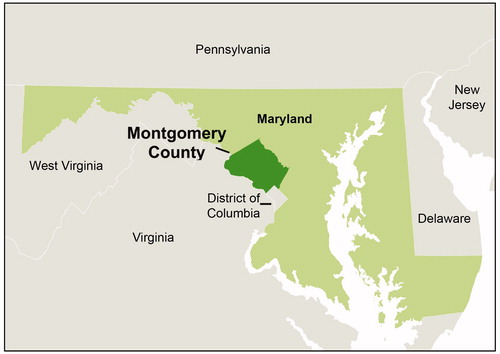
My own archival and ethnographic research (Winston Citation2019) in Black communities in Montgomery County, Maryland (), offers a response to these questions by connecting slavery-era geographies of marronage to a broader geographic praxis of fugitivity sustained through the twenty-first century. Located within a border state between the Confederacy to its south and the free states of the Union to its north, Montgomery County served as an important site of the Underground Railroad during the U.S. Civil War (1861–1865). Maryland itself also became a final destination in many Black people’s flights to freedom when the state abolished slavery on 1 November 1864, more than a year before the Thirteenth Amendment to the Constitution was ratified to officially abolish slavery across the United States. In Montgomery County, some of the marshland, densely forested areas, and isolated places that offered temporary cover and long-term homes to maroons fleeing enslavement became Black communities where residents reject the logics of racial violence that structure the world around them. Across generations, residents of these communities have sustained their own spatial traditions and epistemologies that refuse, disrupt, and elude dominant geographic arrangements.
Figure 1 Montgomery County, Maryland, and surrounding states.
Taken together, the existing geographic scholarship on marronage makes evident that marronage is an ongoing, expansive, and fundamentally spatial practice of building alternative worlds in service of liberation. I contend that postslavery Black freedom struggles should be understood as spatial projects that echo the imperatives of slavery-era fugitivity and the placemaking of maroon geographies. In the following section, I outline a four-part framework of maroon geographies that can guide future geographic scholarship on marronage, Black geographies, and freedom struggles. Throughout, I also apply the framework to examples in Montgomery County, Maryland, to demonstrate how maroon geographies take place across the era of slavery through the present day.
Maroon Geographies
Maroon geographies comprise the physical sites where past flight from slavery occurred—the various rural, urban, and suburban secret hideaways and enclaves that were first established by freed and escaped Black people and either abandoned or sustained as multigenerational Black communities. Maroon geographies also include spaces produced through continued Black struggles around policing, incarceration, housing insecurity, unequal food access, environmental racism, and other overlapping forms of racial violence. Maroon geographies advance alternative ways of understanding and producing space against and outside of these structures of racial violence rooted in the history and legacies of slavery.
Maroon geographies are bound into the fabric of what Gilmore (Citation2018) termed “abolition geography … [the already extant] fragments and pieces, experiments and possibilities” of our future world. As a Black radical tradition, abolition geography emerged from the work of Black people to “quite literally … change places: to destroy the geography of slavery by mixing their labor with the external world to change the world and thereby themselves” (Gilmore Citation2017, 231). The framework of maroon geographies helps to locate the ongoing processes of Black liberation and abolition within a long legacy of Black spatial projects beginning in flight from slavery. In the places where marronage and racial autonomy defined the early parameters of Black life and placemaking, the practice of holding ground outside of racial violence continues to shape the organization of community. Framing contemporary Black placemaking in this way allows scholarship and organizing to start from a place of recognition and reclamation so that the path toward building a racially just world does not simply have to be imagined or discussed abstractly. Black people are already practicing an everyday life of abolition.
Maroon geographies constitute part of a tradition of Black placemaking shaped by subversions and rejections of dominant spatial imaginaries, along with assertions of life-affirming community forms and relationships with the earth. In the following sections, I outline a framework of maroon geographies that centers four main components: (1) reworking geographic refuse, (2) Black cooperative placemaking, (3) fugitive infrastructure, and (4) a spatial strategy of entanglement. These four features characterize maroon geographies spanning from the sixteenth century to the present day.
Reworking Geographic Refuse
Maroon geographies take form through the reworking of geographic refuse—spaces that have been refused incorporation into dominant geographies and development and sites where the people, land uses, and material environment are cast as marginal to the workings of racial capitalism’s ecologies. As mentioned earlier, maroon geographies have historically manifested in the spaces of swamps, mountains, forests, tall grasslands, and other “geographically difficult terrain” (Scott Citation2009, 6). The spatial features characterizing the so-called wilderness, such as “geographical inaccessibility, environmental detriment, [and] economic inefficiency” (Thomas Citation2020, 23) made such areas difficult for transformation by slave labor and, thus, untenable for inclusion in the plantation economy. Whereas land that was “not yet … subjugated to the rule of exchange-value” was considered “worthless waste” according to the logics of capitalism during slavery (Malm Citation2018, 11), it had long been invaluable to Indigenous groups inhabiting and caring for the land. Likewise, carrying their own maroon ecology, Black people escaping slavery used this land as a critical basis for their flight to freedom from racial capitalism and the organized landscape of slavery. In Dominica, for example, the untamable forests beyond the coastlines became a “vast interior realm of maroon power where the whites dared not tread” (Malm Citation2018, 15). In the United States, the Great Dismal Swamp extending between Virginia and North Carolina was another site of geographic difficulty that enabled maroons to establish permanent homes beyond the confines of plantations. All throughout the Americas where slavery took hold, land subsumed into Western notions of wilderness became a premise, or necessary precondition, of freedom for maroons.
Applied to the postslavery era, a framework of maroon geographies invites a consideration of the ways in which Black people transform capital’s refuse into what Malm (Citation2018) called “the cipher of a possible future freedom” (28). Today, most land previously considered to comprise the complicated category of “wilderness” has been tamed, occupied, or otherwise enclosed through colonization and racial capitalism, and transformed into a “controlled, managed garden” (Merchant Citation2003, 389). Nevertheless, the conceptualization of capital’s waste land—and its potential to kindle freedom dreams beyond racial capitalism—can be extended to include sites such as poor, urban and rural “forgotten places” (Gilmore Citation2008). In these forgotten places, “industries of last resort” like incarceration, oil refining, and waste management take hold while “real resolutions of economic, social, and technological problems” are “defer[red] to other places and times” (Gilmore Citation2008, 50). Such places that are principally legible to capitalists through the register of abandonment, however, hold a capacity to generate new ways of life that push up against the constrictions of racial capitalism. The forgotten places of today are conventionally referred to as sites of White flight, deindustrialization, and environmental hazards without considering what else takes place there: the ciphers of freedom that are created. I use examples from Montgomery County, Maryland, to evidence this capacity.
In Montgomery County, Maryland, early Black residents took advantage of land neglected and abandoned by White society to create maroon geographies. More than forty Black communities developed in the county between the late eighteenth century and the late nineteenth century. By 1861, there were fifty-one Black landowners in the county who owned, collectively, a total of 17,142 acres (Afro-American Institute for Historic Preservation and Community Development Citation1978). These communities were often built on land deemed by White people as unworkable for living and farming due to its marshy or rocky conditions (Fly and Fly Citation1983). Those communities formed during slavery offered temporary and, at times, permanent safe havens for maroons. Likewise, Black people who established local communities in the aftermath of slavery continued building whole worlds from sites declared unfit for human life. These communities were, to a large extent, self-sufficient. Residents developed and maintained their own businesses and community institutions—generally churches, schools, and lodges or benefit societies. Their “impulse toward separatism … is rooted in maroonage and the desire to leave the place of oppression for either a new land or some kind of peaceful coexistence” (Kelley Citation2002, 17). Local maroon geographies have withstood time as a result of Black residents’ continuous need to flee and build refuge from racial violence.
Over time, however, many historically Black communities in Montgomery County have disintegrated as a consequence of various social and economic pressures. Real estate developers, in concert with the local and federal government, have bought up much of the land comprising Black communities (Porter Citation1988). A major wave of encroachment came during the 1950s and 1960s with real estate developers buying land to build White suburban neighborhoods and parks (Wraga Citation2001). Another surge in displacement resulted from urban renewal projects in the 1960s and 1970s, whereby many lifelong homes of Black residents were replaced with a reduced number of housing units. With increased property values and the building of townhouses and single-family homes surrounding Black communities during the 1980s, real estate speculators pressured Black residents to sell their homes by repeatedly calling and visiting with inquiries and offers to buy properties (Porter Citation1988; Rathner Citation2005). Industries have also contributed to displacement by building in historically Black communities. In the midst of industry encroachment and real estate development, older residents have passed away and much of the younger population has left for better access to employment opportunities and more affordable housing elsewhere. Other residents have been forced to move as a result of struggles to pay rising property taxes or due to zoning laws that prohibit any further subdivision of family property among descendants (Porter Citation1988). Once numbering more than forty, the Black communities established in Montgomery County between the late eighteenth century and the late nineteenth century have been gradually displaced and erased with this complex set of forces.
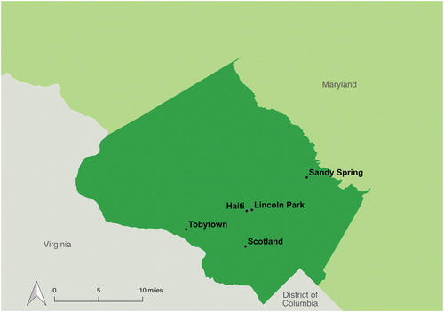
Despite social and economic pressures and shifts, several historically Black communities in Montgomery County still survive as enclaves of Black life. Sustained Black land ownership in county neighborhoods such as Lincoln Park, Haiti (pronounced “Hay-Tie”), Sandy Spring, Scotland, and Tobytown—all of which I discuss in the following sections—has enabled some residents to maintain a world of freedom for themselves (). Successful efforts by residents to hold on to their land through waves of urban renewal and industry and real estate encroachment demonstrate the liberatory possibilities that come to be when Black people have a place of their own. In the following section, I explain the process of Black cooperative placemaking that shapes these communities.
Figure 2 Black communities within Montgomery County study site.
Black Cooperative Placemaking
The transformations of geographic refuse characterizing maroon geographies are made possible by noncapitalist geographic arrangements and cooperative community building. In escaping and building life beyond slavery, historical maroons developed relationships with the earth beyond the conquest and continuous extraction that undergirded slavery. Land, for historical maroons, was not a means for individual ownership and profit; rather, they cared for the earth so that it could provide sustenance to them and serve as a haven for themselves and other fugitives from slavery. In a discussion of enslaved Africans’ relationship to land in the New World, Wynter (Citation1970) called this grounded care ethic a “provision ground ideology,” which opposed the planation ideology by centering the earth as “the base of the community, and … the common good” (37). In multigenerational maroon settlements in the Great Dismal Swamp, for example, groups of maroons isolated themselves from the political economy of slavery and worked collectively to create gardens, build shelters, and produce stone tools and ceramics from locally available swamp materials (Sayers Citation2014).
Following the abolition of slavery, noncapitalist relationships with the earth and cooperative community forms continued to shape maroon geographies. After slavery was abolished in Dominica in 1834, for example, Black Dominicans who were formerly enslaved moved inland from coastal plantations to join maroons in subsistence farming and small-scale trade (Malm Citation2018). After visiting Dominica in 1860, English novelist Anthony Trollope criticized the absence of capitalism’s influence: “There are no shops that can properly so be called. The people wander about, idle, chattering, listless; there is no sign of money made or of money making” (cited in Malm Citation2018, 15). Likewise, in the United States, a “Black community ethos” of “freedom, education, self-determination, racial solidarity, survival and resistance” (Organ Citation1995, 1–2) that originated in maroon geographies was distilled in later stages of Black settlement including free Black communities situated along the Underground Railroad (LaRoche Citation2014), freedman villages and freedom colonies formed during and after the U.S. Civil War (A. R. Roberts Citation2018b), and Black enclaves in contemporary suburban and urban landscapes (Thomas Citation2020). Throughout the Americas, “the Black commons” that maroons created to refuse and renegotiate the spatial and economic conditions of slavery survived in ongoing “practices of alternative earth stewardship … [and in] the novel social infrastructures and institutions they created in slavery’s aftermath, despite their experiences with segregation, isolation, and enmity” (Roane Citation2018, 256).
In Montgomery County, Maryland, until the late twentieth century, maroon geographies were shaped by cooperative living strategies rooted in a “place-based ethics of care” (Till Citation2012, 8). For example, a number of Black communities were organized around collective, community-defined land tenure instead of private, individual land ownership. This collective tenure allowed land to be used as a material basis for care. Residents often shared parcels of land, building their own homes and subdividing their properties between family members and neighbors (Porter Citation1988). The physical environments that residents built reinforced their shared, community-based understandings of land. In the county’s Black community of Haiti, for example, “fences, alleys, and other natural boundaries did not defensively proclaim individual ownership”; instead, property lines were unclear and land appeared as “community property” (Maryland Historical Trust n.d., 4). In addition, because Black residents were skeptical of the government, they did not always follow official procedures for recording and transferring property ownership. For example, Black residents living in the community of Sandy Spring systematically refused to file deeds to their properties because they were afraid to attract the attention of the government (Porter Citation1988). Likewise, Scotland community residents did not often designate land to particular descendants in their wills and, consequently, the community did not have clear land titles (Siegel Citation1973). In this way, residents engaged in structural flight from the state and from the restrictions of the capitalist land market.
The place-based care ethic in Montgomery County’s maroon geographies also encompassed subsistence strategies that were passed down generationally.
From the founding of local Black communities, residents cultivated gardens and raised livestock: By working their land, they provided the basic foodstuffs from garden produce, orchards, and animals so that their families could survive and perhaps come out a little ahead by bartering their surplus. As they had during slavery, the founders depended upon one another and upon themselves. They helped neighbors to build their own houses, clear their land, butcher animals, and preserve the meat. (McDaniel Citation1979, 155)
Such place-based acts of subsistence and care enabled local Black communities to establish relative autonomy from an economy that profited from the labor, servitude, and consumption needs of workers ranging from enslaved people on plantations to postslavery wage laborers.
The cultivation of Black worlds of care in Montgomery County, and across the globe, is indebted to the historical and ongoing efforts of Black women to construct “homeplaces,” defined by hooks (Citation2001) as “spaces of care and nurturance [created] in the face of the brutal harsh reality of racist oppression … [and] sexist domination” (384). The Black homeplace forms a site of struggle and resistance that affirms Black people and sustains Black life. In our contemporary context, the homeplace remains a central site of Black “aspiration, cultural continuity, and survival” against white surveillance (A. R. Roberts Citation2019, 74). As a testament to the endurance of the homeplace, a resident still living in Sandy Spring in 2018 described her childhood to me, saying, “It was like we were in our own little kingdom kind of thing,” where everyone took on a specific role for the community so that all needs were met. Across historically Black communities in Montgomery County, residents still maintain strong social ties and support networks.
In many ways, local Black communities’ abandonment and suppression by the state required Black residents to develop livelihoods and epistemologies of care outside the register of violently restrictive governance. Although state neglect is not celebratory, Black freedom struggles are epistemically incomplete without attending to the entire worlds created within abandonment. Referencing the Black community of Scotland, for example, a 1975 Montgomery County Human Relations memorandum concluded with the following observation: “That community is more determined to do for itself than any community I know of. All the county could and should do is stand by and be available” (Montgomery County Human Relations Commission Citation1975). A focus on the radical acts and structure of care—rather than simply a focus on the shared oppressions—shaping maroon geographies draws attention to the critical ways that Black communities “can themselves be a site of redress” and world building away from oppression and domination (Nash Citation2013, 15).
Even as certain cooperative arrangements have come to an end or have significantly transformed within maroon geographies, marronage continues to be a useful frame for understanding the possibilities of placemaking beyond racial capitalism. The ongoing abandonment of Black communities by government and private capital necessitates that Black people organize cooperative, noncapitalist geographic and social arrangements—albeit often entangled with practices of land ownership, wage labor, and other activities that do not allow for complete extrication from racial capitalism. Maroon geographies provide a framework for interrogating this ongoing abandonment and entanglement while emphasizing the social worlds that Black people build within it. In addition, maroon geographies help underscore how the marginality resulting from this abandonment can inspire and incubate fugitive infrastructure, which I turn to in the following section.
Fugitive Infrastructure
Infrastructures are material systems that organize and sustain everyday life. Dominating our past and present world are infrastructures like railways, oil pipelines, damns, borders, and policing systems that foster life and connectivity for some by engineering dispossession and containment for others (Cowen Citation2017). Maroon geographies defy these infrastructures of domination. They constitute a form of what Cowen (Citation2017) called “fugitive infrastructures”: material arrangements produced through cumulative efforts by everyday people to organize and sustain life when possibilities for survival seem foreclosed. Emerging in opposition to auction blocks, plantations, slave patrols, and other infrastructures of chattel slavery, maroon geographies have always operated as a “furtive and tenuous infrastructure” encompassing the material conditions of Black refusal (Roane Citation2018, 256). In the postslavery world, the fugitive infrastructure animating maroon geographies systematically pushes back against the power and ongoing violence of anti-Black infrastructure.
The language of fugitivity, in relation to infrastructure, illuminates how everyday survival acts often deemed unlawful can combine into a material basis for struggle. In maroon geographies, fugitive infrastructure forms through Black people’s creative work—often bordering on the “extralegal” or “criminal”—to “sustain living in the context of intermittent wages, controlled depletion, economic exclusion, coercion, and antiblack violence” (Hartman Citation2019, 237). The disregarding of such work as aberrant and criminal has facilitated systematic disavowals of a robust fugitive infrastructure undergirding Black geographies. Across the history of marronage in North America, this has occurred through White efforts to deny the existence of marronage and to atomize Black flight from slavery with terminology such as “runaways,” “outliers,” and “banditti” (Diouf Citation2014, 3). Far from disconnected, however, the acts of Black flight and survival that shape maroon geographies consolidate into an entire infrastructure.
Fugitive infrastructure delineates an organizing framework through which to comprehend people’s adaptability and reactions to oppressive structures not as isolated and individual but as equally structural as the structures they resist. In formulating abolition geography, Gilmore (Citation2017) asserted that “feeling and agency … [are] constitutive of, no less than constrained by, structure” (238). In other words, although dominant structural forces like urban development, policing, and incarceration certainly constrain human life and agency, everyday people also systematically build fugitive infrastructure against and outside of the “space, time and legality” (Cowen Citation2017) of these dominant infrastructural projects. This is not to say that people’s daily decision making might be predetermined by the fugitive infrastructures that might organize their lives. Rather, fugitive infrastructure lends coherence to the unbounded ways in which “ordinary people and communities assert their own renderings of life and living rather than those of the state, capital and other dominions’ terms of order” (Quan Citation2017, 178).
Fugitive infrastructure in Montgomery County’s maroon geographies manifests through creative efforts by Black residents to make life more bearable in the face of state abandonment and concentrated poverty. Black communities in Montgomery County, like those throughout the United States, developed with a deliberate lack of investment from public and private capital. The local community of Tobytown, for example, lacked a trash collection service until around 1965 (Douglas Citation1965). Up until 1972, just one dirt street ran through the neighborhood (Bonner Citation1974) and most homes in the community lacked plumbing and electricity (Wraga Citation2003). The neighborhood was also isolated from public transit access to other parts of the county. In fact, just in 2016, after decades of residents pressing the county for better transit service, the Montgomery County Council approved a bus route that would service Tobytown (Shaver Citation2016). Prior to this, Tobytown’s closest bus stop was “three miles away on a narrow country road with no sidewalks or paved shoulders to separate pedestrians from vehicles whizzing past” (Shaver Citation2016). This lack of transportation access made it difficult for residents to secure stable employment with livable wages (Bonner Citation1974). During the 1970s, Tobytown was known as “an isolated, poor community of blacks living in drafty, overcrowded shacks on a single dirt street, within sight of rich horse farms and rolling estates in Potomac, one of the wealthiest sections of Montgomery County” (Bonner Citation1974).
Tobytown residents, like members of other Black communities in Montgomery County, however, transformed this geography of public and private capital abandonment into a usable fugitive infrastructure. Early Tobytown residents constructed illegal affordable dwellings made of cinderblocks, wooden packing crates, corrugated iron, and other materials (Douglas Citation1965). Residents continued living in their homes despite twenty-three out of the neighborhood’s thirty-five homes being condemned by 1964 (Wraga Citation2001). In addition, in the absence of heat and plumbing, residents heated their homes using wood stoves in the winter and they created a community privy. They also raised livestock, hunted small game, and grew their own produce in communal gardens. They created a haven for themselves that, although situated on the losing side of uneven capitalist development, allowed them to win the struggle to define and practice community on their own terms.
The fugitive infrastructure of Montgomery County’s maroon geographies is built not only through Black residents’ systematic will to survive by defying dominant terms of social order but also through the consolidation of radically alternative norms and ethics to govern their lives. For example, Black residents of Montgomery County developed their own fire response team, which was the first and only volunteer fire department in the county up until 1921 (Pathik Citation1975). In Tobytown, the community was kept secure not by police but by community members themselves. A former resident of the community Haiti, Annie Rhodes, remembers an old Black man who lived in Tobytown who used to sit on an overturned bucket at the entrance to his community to prevent intruders from entering. On Annie’s first visit to Tobytown, the man got up from his bucket, and walked up to the side of her car, and she had to explain to him her purpose for visiting and who invited her to visit. Reflecting on the encounter, Annie told me, “He was like their policeman.” Annie explained that, after she provided sufficient justification for her visit, the man said “Go on by, lady,” and she was told which house to go to. Every time Annie visited Tobytown after that, she said, the old man was there, keeping guard. Tobytown’s community-based security system is reminiscent of the Bear Creek maroon community, established in Georgia during the 1780s. This seventeen-acre settlement of approximately 100 people was protected by a four-foot-tall breastwork that had a small opening to admit one person at a time (Diouf Citation2014). In addition, Bear Creek maroons created a barrier of large trees to prevent boats from passing through the nearby creek, and they placed a sentry outside of the settlement’s borders (Diouf Citation2014). Such defense measures were designed for the maroon community to protect themselves when attacked by militia troops. In Tobytown, the use of a similar system indicates the persistence of maroon epistemologies of safety and security across time and space. Maroon geographies are characterized by an ongoing rejection of state authority in favor of alternative methods to secure residents’ well-being.
When, in 1972, the Housing Authority of Montgomery County was awarded funds by the U.S. Department of Housing and Urban Development for an urban renewal project in Tobytown, the community held ground against this vision of development. Federal urban renewal programs were designed, in part, to sanitize cities of places built on fugitive infrastructure. Tobytown’s urban renewal project—which included the tearing down of old houses and the construction of twenty-six “modern brick and wood homes” in the community along with a community center and plans for a recreational park (Bonner Citation1974)—required residents to sell and then rent (on the government’s terms) the land that their families had been living on for about 100 years. Residents were afforded the option to buy the new homes only after abiding by the Montgomery County Housing Opportunities Commission’s (HOC) requirements for tenants to be “models of upward mobility” who met the “strict criteria” of having “jobs, their own transportation, and stable family relationships” (Wiener Citation1977).
Whereas urban renewal programs identified spreading “crime and public disorder” as detrimental conditions of urban blight (President’s Task Force on Urban Renewal Citation1970), Tobytown residents refused to reduce their community’s fugitivity to a problem. Residents were upset about having to rent from the county HOC and follow its terms of order. Many complained about the HOC’s attacks on forms of community leisure and bonding activities and expressed dismay with the increased governance in Tobytown. For example, James Chambers noted disdainfully, “Nobody’s causing problems here. We stand around, we drink sometimes, but we’re not bothering anybody” (Wiener Citation1977). Likewise, Tobytown resident Lord Martin, who was about sixty years old at the time, complained about the changes. He explained, although the houses “back then” were falling apart, he liked his community much better: “I would much rather go back to living the way it was before. Then I could raise my hogs. Now I can’t raise anything. They [officials] won’t allow it” (Singh Citation1981). Many residents also worried about evictions and even refrained from sharing their experiences with news reporters due to fear of retaliation from the HOC (Singh Citation1981). Rufus Ragin, HOC tenant counsel, explained the discomfort that Tobytowners had with adjusting to the changes in their neighborhood: “It’s like asking a fish to live on land” (Singh Citation1981). For Tobytown residents, their unboundedness from dominant terms of order played an important role in sustaining their livelihoods and sense of place.
Nonconforming land uses comprised one example of fugitive infrastructure that survived urban renewal in Tobytown. For example, in 1974, only three residents had planted in the designated communal garden plot set aside during the previous year by the housing agency. Instead, residents like Henson Davis continued to use their existing gardens. After his home was replaced with an HOC-owned townhouse, Davis continued to maintain his backyard garden just some steps from his new back door, where he planted onion, cabbage, and tomato plants (Bonner Citation1974). Similarly, Tobytowner Lord Martin continued to “hunt rabbits and stuff” (Singh Citation1981). Perhaps seemingly insignificant, such responses by Tobytown residents to the urban renewal project in their neighborhood show how alternative relationships with land can take place within the constraints of state power and unfulfilled struggles for Black land.
Even Tobytowners’ visions of land ownership underscore ongoing fugitivity as a bedrock of the community’s infrastructure. For example, almost a decade after urban renewal in Tobytown, community resident Melvin Martin proclaimed, “Ain’t no way I am going to give up my house. For this I will fight it out, even if it means going to jail. I am not going to rest until I own the house” (Singh Citation1981). Melvin Martin’s proclamation speaks to what A. R. Roberts (Citation2018a) called “unkempt notions of … land ownership” through which “seemingly errant people or places” have been integral to historical Black communities and settlements across the United States (68). In the context of state-sanctioned racial dispossession, Black land and community can themselves be errant, or fugitive, acts. Although Black land ownership that “appeals to the settler colonial state” should not be exempt from interrogation in ongoing structures of colonialism and capitalism (Pulido and De Lara Citation2018, 78), fugitive infrastructure is a framework for understanding Black land as capable of sustaining life outside of the registers of dispossession, domination, and profit.
The fugitive infrastructure of Tobytown and other local Black communities speaks to a long tradition of marronage. For generations, over the course of over 200 years, residents of Black communities in Montgomery County have been fleeing and building community life outside of the oppressions of state-making projects—including slavery, policing, and urban renewal. The work of Black people to construct and maintain fugitive infrastructure in the face of unremitting state and state-sanctioned violence is both a painful indictment of and a radical departure from the racial capitalist state’s terms of order.
A Spatial Strategy of Entanglement
It is important to emphasize that the characteristics of maroon geographies are not unconsciously and automatically reproduced in the space of relatively autonomous Black communities. Rather, maroon geographies are continuously reinforced and, at times, also contradicted. As liminal sites between bondage and the complete abolition of slavery, maroon geographies hold countless histories of complicated entanglements with structures of unfreedom. At times, maroons had to leave behind or turn in other freedom seekers in exchange for their own freedom. Even some of the most formidable maroon settlements in Jamaica and Suriname, for example, compromised with state authorities by turning over runaways in exchange for official recognition of their independence (Diouf Citation2014). Moreover, a majority of those left behind by maroons were enslaved children and the women who bore and raised them. Although women did contribute to marronage by harboring and caring for maroons and by becoming maroons themselves—the quintessential example being Queen Nanny of the Windward Maroons of Jamaica—their reproductive labor responsibilities posed additional challenges to escaping from slavery (Diouf Citation2014). By contrast, enslaved men often had more knowledge of the outside world and invited fewer suspicions compared to women, children, and other groups because they were afforded some limited mobility to travel outside the plantation for errands and other tasks (Diouf Citation2014). Maroon geographies thus echoed structures of racial, sexual, and gender domination even as maroons escaped from the center of those oppressions.
Due to the compromises that maroons deliberately made, Bonilla (Citation2015) explained that marronage itself “represents a form of strategic entanglement: a way of crafting and enacting autonomy within a system from which one is unable to fully disentangle” (43). Building from Bonilla, I delineate spatial strategies of entanglement as encompassing the generative use of the physical and built environments of structurally abandoned places to adapt to systemic constraints and simultaneously maintain spaces of Black freedom. These strategies shape the geographic contexts of historical and ongoing marronage.
The strategic entanglements of maroon geographies provide lessons for how to grapple with freedom struggles when the path to liberation is not clear cut. In Montgomery County, for example, maroon geographies are characterized by negotiations with state actors that, while replicating existing power relations in some ways, still support residents’ resistance to state and state-sanctioned racial violence. Simply put, while maroon geographies extend beyond racial capitalism and its systems of racial, sexual, gender, and class governance, they remain in conflict and relation with dominant actors and structures.
As an example of a strategic entanglement, I turn to the Black community of Lincoln Park in Rockville City, Montgomery County. In 2012, Lincoln Park residents converted a police substation into a community-run tutoring and mentoring space for community youth. The conversion was led by the Lincoln Park Community Center director, a Black woman who asked the local Rockville City Police Department that the substation be turned over for use as a community space because she saw no need for physical police infrastructure in the community. In fact, the police substation had been slowly transforming into a community space over the years since its use by police had significantly declined by the early 2000s. Residents told me they very rarely called the police, and the neighborhood was generally quiet according to the neighborhood civic association. Given the lack of need for dedicated police space, the community center staff used part of the substation for storage and even had a key to the substation while it was still in use by police. Wanting to fully take advantage of the opportunity to have more space of their own, the Lincoln Park Community Center director had the usage officially changed. In its new role as a tutoring and mentoring space funded by the local government, the former police substation has been filled with educational materials for neighborhood children and desk space for volunteer tutors and mentors. There are books donated from the Montgomery County Public School system, and the space has been used for Lincoln Park youth programs as well as a summer mentorship program run by the City of Rockville’s Community Services Department.
In their conversion of their neighborhood’s police substation, Lincoln Park residents mobilized a spatial strategy of entanglement predicated on a paradoxical expansion of local police infrastructure. The same year that Lincoln Park residents were able to take over the police substation for themselves, a new police headquarters opened in downtown Rockville as the culmination of a $6.4 million project designed to accommodate the current police force and allow for ten percent growth (City of Rockville Planning Commission Citation2013). With the opening of the new police headquarters, Lincoln Park residents were able to convince the police department that it no longer needed the space in their community. This development in police infrastructure thus allowed local residents to combat the intimate policing of their neighborhood by physically transforming the existing police substation.
Lincoln Park residents’ strategic entanglements with the state suggest how state resources can be appropriated without replicating state violence. Although police are still present, residents have reworked state resources in their neighborhood so that they are no longer in service of a violent form of state governance. At the same time, the substation conversion highlights how the constraints of state power can remain intact—albeit in a new geographic configuration enabled in this case by a new police headquarters. Acknowledging the ways in which maroon geographies articulate with modes of state governance and racial capitalism “in dialectical, or contradictory, and transformational ways” (Sayers Citation2014, 8) creates space for interrogating and addressing the limitations of present negotiations with power while still centering radical imaginations.
Conclusion: The Work of Maroon Geographies
This article has argued for a unified framework of maroon geographies that can contribute to critical scholarship and freedom struggles. Historical and contemporary maroon geographies evidence existing and emerging methods for challenging and transforming dominant geographic arrangements to build worlds of freedom. In scholarship and organizing, a framework of maroon geographies can allow us to frame issues differently, ask different questions, and imagine different futures.
The tradition of Black placemaking evident in maroon geographies offers four critical guideposts for future work examining and contributing to Black freedom struggles. First, the framework of maroon geographies helps to locate sites of radical transformation in the margins and wastelands of dominant spatial projects. Second, maroon geographies illustrate ongoing ways in which Black people reject the geographic arrangements of racial capitalism and build forms of community centered on cooperation and racial solidarity. Third, geographies of marronage show how Black refusals could consolidate into an entire infrastructure of fugitivity that organizes and sustains life beyond racial violence. Finally, this framework contributes a way of understanding the strategic entanglements that make possible advances in Black freedom struggles within contexts of seeming impossibility.
Building from existing scholarship on marronage and the work of Black geographies, a framework of maroon geographies can strengthen analyses of the legacies of slavery-era violence alongside the spatial inheritances of Black resistance and struggle. Just as the work of Black geographies does not simply end at the identification of places that Black people inhabit, maroon geographies do not only draw attention to the physical sites where flight from slavery occurred. As Black geographies encompass the dynamic and continuous ways in which Black productions of space demand and model possibilities for a more just world, maroon geographies underscore the indelible impacts of marronage in a Black radical project of producing space.
Moreover, the global scale of maroon geographies helps to illuminate long-term, interconnected spatial praxes of Black struggle across the world. Although this article has focused on a small case study based in the Americas, maroon geographies extend beyond the Western hemisphere. Marronage has also influenced the settlement of Liberia (T. P. Woods Citation2019) and past flight from and rebellion against slavery in coastal West Africa (Rashid Citation2000; Mouser Citation2007) and the Indian Ocean region (Alpers Citation2003; Allen Citation2004). In the postslavery era, marronage has continued to inform movement building among far-ranging groups including Black transgender and gender-nonconforming prison abolitionists in the United States and Canada (Sudbury Citation2009); Afro-Brazilians struggling for rural land redistribution and environmental justice (Bledsoe Citation2017; Shore Citation2017); and the decolonial feminist collective, Marronage, based in Copenhagen, Denmark, which draws connections between the history of marronage and present-day international countermovements against neocolonialism, racial capitalism, and patriarchy (Marronage Citation2017). The scalar reach of maroon geographies can serve as a scaffolding to identify sites of global solidarity and consciousness building that are attentive to the legacies of “colonialism, slavery, capitalism, and empire” that intimately intertwine Europe, Africa, Asia, and the Americas (Lowe Citation2015, 2).
The ongoing geographic histories of marronage offer a blueprint for transformative racial justice. In many ways, the legacies of marronage and slavery abolition already inform struggles against policing and incarceration and for racial liberation more broadly. The maroon geographies framework formulated in this article can help structure future scholarship and organizing around those enduring legacies. For example, although beyond the scope of this article, my research in Montgomery County, Maryland, identifies a wealth of lessons for police abolition embedded in local maroon geographies. The reworking of geographic refuse, Black cooperative placemaking, infrastructural fugitivity, and spatial strategies of entanglement animating maroon geographies there demonstrate how to practice safety, security, and community beyond policing in places where police have developed from and persisted since slave patrols. Just as slavery’s inheritances continue to shape police and other contemporary structures of racial violence, maroon geographies persist as sites for fleeing and producing space beyond those violences. Marronage is a continuously expansive, radical geography full of lessons for building a racially just world.
Acknowledgments
I would like to express gratitude to Ruth Wilson Gilmore, Katherine McKittrick, Marianna Pavlovskaya, and Robyn Spencer for their encouraging feedback on the research that led to this article. This research was also made possible by the archivists and present-day maroons in Montgomery County, Maryland. The article was improved by feedback from the anonymous reviewers and my colleagues Ajima Olaghere and Danya Pilgrim in Temple University’s Junior Faculty Writing Collective. Finally, I owe tremendous thanks to my partner Jalil Mustaffa Bishop for thoughtful feedback on this article and the research leading up to it.
Additional information
Notes on contributors
Celeste Winston
CELESTE WINSTON is an Assistant Professor in the Department of Geography and Urban Studies, Temple University, Philadelphia, PA 19122. E-mail: [email protected]. Her research interests include the intersections between Black and carceral geographies, and police and prison abolition.
References
- Afro-American Institute for Historic Preservation and Community Development. 1978. A study of historic sites in the Metropolitan Washington regions of Northern Virginia and Southern Maryland importantly related to the history of Afro-Americans Part III. Lincoln Park Folder I, Year 2003 Folder, Peerless Rockville, Afro-American Institute for Historic Preservation and Community Development, Washington, DC.
- Agorsah, E. K. 1994. Maroon heritage: Archaeological, ethnographic, and historical perspectives. Barbados: Canoe Press.
- Allen, R. B. 2004. A serious and alarming daily evil: Marronage and its legacy in Mauritius and the colonial plantation world. Slavery & Abolition 25 (2):1–17. doi: https://doi.org/10.1080/0144039042000293009.
- Alpers, E. A. 2003. Flight to freedom: Escape from slavery among bonded Africans in the Indian Ocean world, c.1750–1962. Slavery & Abolition 24 (2):51–68. doi: https://doi.org/10.1080/01440390308559155.
- Aptheker, H. 1939. Maroons within the present limits of the United States. The Journal of Negro History 24 (2):167–84. doi: https://doi.org/10.2307/2714447.
- Aptheker, H. 1947. Additional data on American maroons. The Journal of Negro History 32 (4):452–60. doi: https://doi.org/10.2307/2714927.
- Bledsoe, A. 2016. Defender Nosso Pedaço de Chão: Quilombola Struggles in Bahia. PhD diss., The University of North Carolina at Chapel Hill.
- Bledsoe, A. 2017. Marronage as a past and present geography in the Americas. Southeastern Geographer 57 (1):30–50. doi: https://doi.org/10.1353/sgo.2017.0004.
- Bonilla, Y. 2015. Non-sovereign futures: French Caribbean politics in the wake of disenchantment. Chicago: University of Chicago Press.
- Bonner, A. 1974. Tobytown: New housing, old problems. Washington Post, July 5.
- City of Rockville Planning Commission. 2013. Annual report 2012. https://www.rockvillemd.gov/DocumentCenter/View/5107/Planning-Commission-Annual-Report-2012?bidId.
- Cowen, D. 2017. Infrastructures of empire and resistance. https://www.versobooks.com/blogs/3067-infrastructures-of-empire-and-resistance.
- Davis, J., A. A. Moulton, L. Van Sant, and B. Williams. 2019. Anthropocene, Capitalocene, … Plantationocene? A manifesto for ecological justice in an age of global crises. Geography Compass 13 (5):e12438. doi: https://doi.org/10.1111/gec3.12438.
- Diouf, S. A. 2014. Slavery’s exiles: The story of the American maroons. New York: New York University Press.
- Douglas, W. B. 1965. A house is not a home in Toby Town: It’s a crate. Washington Post, November 14.
- Ferretti, F. 2019. Decolonizing the Northeast: Brazilian subalterns, non-European heritages, and radical geography in Pernambuco. Annals of the American Association of Geographers 109 (5):1632–50. doi: https://doi.org/10.1080/24694452.2018.1554423.
- Fly, E. L., and L. B. W. Fly. 1983. Northeastern Montgomery County Black oral history study. Montgomery County, MD: Entourage, Inc.
- Gilmore, R. W. 2007. Golden gulag: Prisons, surplus, crisis, and opposition in globalizing California. Berkeley: University of California Press.
- Gilmore, R. W. 2008. Forgotten places and the seeds of grassroots planning. In Engaging contradictions, ed. C. R. Hale, 31–61. Berkeley: University of California Press.
- Gilmore, R. W. 2017. Abolition geography and the problem of innocence. In Futures of Black radicalism, ed. G. T. Johnson and A. Lubin, 225–40. New York: Verso.
- Gilmore, R. W. 2018. Making abolition geography in California’s Central Valley. https://thefunambulist.net/making-abolition-geography-in-californias-central-valley-with-ruth-wilson-gilmore.
- Hartman, S. 2019. Wayward lives, beautiful experiments: Intimate histories of social upheaval. New York: Norton.
- Hawthorne, C. 2019. Black matters are spatial matters: Black geographies for the twenty-first century. Geography Compass 13 (11):e12468. doi: https://doi.org/10.1111/gec3.12468.
- hooks, b. 2001. Homeplace (a site of resistance) (1990). In Available means: An anthology of women’s rhetoric(s), ed. J. Ritchie and K. Ronald, 383–90. Pittsburgh, PA: University of Pittsburgh Press.
- Joyce, R. 2017. “Bitch out of hell”: The queer urban marronage of Assotto Saint. Women & Performance: A Journal of Feminist Theory 27 (2):176–93. doi: https://doi.org/10.1080/0740770X.2017.1315230.
- Kelley, R. D. G. 2002. Freedom dreams: The Black radical imagination. Boston: Beacon Press.
- Krueger-Henney, P., and J. Ruglis. 2020. PAR is a way of life: Participatory action research as core re-training for fugitive research praxis. Educational Philosophy and Theory 52 (9):961–72. doi: https://doi.org/10.1080/00131857.2020.1762569.
- LaRoche, C. J. 2014. Free Black communities and the Underground Railroad: The geography of resistance. Urbana: University of Illinois Press.
- Leaming, H. P. 1979. Hidden Americans: Maroons of Virginia and the Carolinas. Chicago: University of Illinois.
- Lebrón Ortiz, P. 2019. Maroon logics as flight from the Euromodern. TRANSMODERNITY: Journal of Peripheral Cultural Production of the Luso-Hispanic World 9 (2):1–20.
- Leone, M. P., C. J. LaRoche, and J. J. Babiarz. 2005. The archaeology of Black Americans in recent times. Annual Review of Anthropology 34 (1):575–98. doi: https://doi.org/10.1146/annurev.anthro.34.081804.120417.
- Lowe, L. 2015. The intimacies of four continents. Durham, NC: Duke University Press.
- Malm, A. 2018. In wildness is the liberation of the world: On maroon ecology and partisan nature. Historical Materialism 26 (3):3–37. doi: https://doi.org/10.1163/1569206X-26031610.
- Marronage. 2017. Marronage (English). https://marronage.dk/english/.
- Maryland Historical Trust. n.d. Haiti/Martin’s Lane Survey District—Maryland Historical Trust State Historic Sites Inventory Form, Section 7. Communities—Haiti Folder, Jane C. Sween Library, Rockville, MD.
- McDaniel, G. W. 1979. Reflections of Black heritage: An architectural and social history of Black communities in Montgomery County, Maryland. Barnesville, MD: Sugarloaf Regional Trails.
- McKittrick, K. 2006. Demonic grounds: Black women and the cartographies of struggle. Minneapolis: University of Minnesota Press.
- McKittrick, K. 2011. On plantations, prisons, and a Black sense of place. Social & Cultural Geography 12 (8):947–63. doi: https://doi.org/10.1080/14649365.2011.624280.
- McKittrick, K. 2013. Plantation futures. Small Axe: A Caribbean Journal of Criticism 17 (3):1–15. doi: https://doi.org/10.1215/07990537-2378892.
- McKittrick, K., and C. Woods. 2007. No one knows the mysteries at the bottom of the ocean. In Black geographies and the politics of place, ed. K. McKittrick and C. Woods, 1–13. Cambridge, MA: South End Press.
- Merchant, C. 2003. Shades of darkness: Race and environmental history. Environmental History 8 (3):380–94. doi: https://doi.org/10.2307/3986200.
- Montgomery County Human Relations Commission. 1975. Memorandum: Reported unrest in the Scotland community. Human Relations Commission 1957–1996, Record Group 15: Boards and Commissions, Series VI: Justice Committee, 1967–1976, Compliance Complaints (restricted folder), Montgomery County Archives, Gaithersburg, MD.
- Mouser, B. 2007. Rebellion, marronage and jihād: Strategies of resistance to slavery on the Sierra Leone Coast, c. 1783–1796. The Journal of African History 48 (1):27–44. doi: https://doi.org/10.1017/S0021853706002490.
- Mulroy, K. 2003. Freedom on the border: The Seminole maroons in Florida, the Indian territory, Coahuila, and Texas. Lubbock: Texas Tech University Press.
- Nash, J. C. 2013. Practicing love: Black feminism, love-politics, and post-intersectionality. Meridians 11 (2):1–24. doi: https://doi.org/10.2979/meridians.11.2.1.
- Organ, D. J. 1995. The historical geography of African-American frontier settlement. PhD diss., University of California, Berkeley.
- Pathik, C. 1975. County Blacks: They came a long way. Montgomery Journal, April 17.
- Porter, P. 1988. Blacks try to preserve their land, heritage. Montgomery Journal, November 15.
- President’s Task Force on Urban Renewal. 1970. Urban renewal: One tool among many. The report of the President’s Task Force on Urban Renewal. Washington, DC: U.S. Government Printing Office. https://hdl.handle.net/2027/mdp.39015028082124.
- Price, R., ed. 1973. Maroon societies: Rebel slave communities in the Americas. Garden City, NY: Anchor.
- Price, R. 1975. Saramaka social structure: Analysis of a maroon society in Surinam. Río Piedras: Institute of Caribbean Studies, University of Puerto Rico.
- Price, R. 1976. The Guiana maroons: A historical and bibliographical introduction. Baltimore, MD: Johns Hopkins University Press.
- Pulido, L., and J. De Lara. 2018. Reimagining “justice” in environmental justice: Radical ecologies, decolonial thought, and the Black radical tradition. Environment and Planning E: Nature and Space 1 (1–2):76–98. doi: https://doi.org/10.1177/2514848618770363.
- Quan, H. L. T. 2017. “It’s hard to stop rebels that time travel”: Democratic living and the radical reimagining of old worlds. In Futures of Black radicalism, ed. G. T. Johnson and A. Lubin, 173–93. New York: Verso.
- Rashid, I. 2000. Escape, revolt, and marronage in eighteenth and nineteenth century Sierra Leone hinterland. Canadian Journal of African Studies/Revue Canadienne Des Études Africaines 34 (3):656–83. doi: https://doi.org/10.1080/00083968.2000.10751210.
- Rathner, J. L. 2005. Generations of residents settle down in Scotland. Washington Post, June 18.
- Roane, J. T. 2018. Plotting the Black commons. Souls 20 (3):239–66. doi: https://doi.org/10.1080/10999949.2018.1532757.
- Roberts, A. R. 2018a. Count the outside children! Kinkeeping as preservation practice among descendants of Texas’ freedom colonies. Forum Journal 32 (4):64–74. doi: https://doi.org/10.1353/fmj.2018.0022.
- Roberts, A. R. 2018b. Performance as place preservation: The role of storytelling in the formation of Shankleville community’s Black counterpublics. Journal of Community Archaeology & Heritage 5 (3):146–65. doi: https://doi.org/10.1080/20518196.2018.1480002.
- Roberts, A. R. 2019. Until the Lord come get me, it burn down, or the next storm blow it away. Buildings & Landscapes 26 (2):73–97. doi: https://doi.org/10.5749/buildland.26.2.0073..
- Roberts, A. R. 2020. Haunting as agency. ACME: An International Journal for Critical Geographies 19 (1):210–44.
- Roberts, N. 2015. Freedom as marronage. Chicago: The University of Chicago Press.
- Robinson, C. J. 2000. Black Marxism: The making of the Black radical tradition. Chapel Hill: University of North Carolina Press.
- Sayers, D. O. 2014. A desolate place for a defiant people: The archaeology of maroons, Indigenous Americans, and enslaved laborers in the Great Dismal Swamp. Gainesville: University Press of Florida.
- Scott, J. C. 2009. The art of not being governed: An anarchist history of upland Southeast Asia. New Haven, CT: Yale University Press.
- Shaver, K. 2016. Tobytown finally gets a bus. Washington Post, May 27. https://www.washingtonpost.com/news/dr-gridlock/wp/2016/05/27/tobytown-finally-gets-a-bus/?utm_term=.229b67e77ddc.
- Shore, E. 2017. Geographies of resistance: Quilombos, Afro-descendants, and the struggle for land and environmental justice in Brazil’s Atlantic forest. Afro-Hispanic Review 36 (1):58–78.
- Siegel, J. B. 1973. Oral history of Joyce B. Siegel transcript. Montgomery County Archives, Gaithersburg, MD.
- Singh, J. 1981. Tobytown: A decade later. Montgomery Journal, February 13.
- Sudbury, J. 2009. Maroon abolitionists: Black gender-oppressed activists in the anti-prison movement in the U.S. and Canada. Meridians 9 (1):1–29. doi: https://doi.org/10.2979/MER.2008.9.1.1.
- Thomas, L. L. 2020. Maroon colonies and New Orleans neutral grounds: From a protosuburban past to a postsuburban future. Urban Geography 41 (1):21–26. doi: https://doi.org/10.1080/02723638.2019.1614370.
- Thompson, A. O. 2006. Flight to freedom: African runaways and maroons in the Americas. Kingston, Jamaica: University of West Indies Press.
- Till, K. E. 2012. Wounded cities: Memory-work and a place-based ethics of care. Political Geography 31 (1):3–14. doi: https://doi.org/10.1016/j.polgeo.2011.10.008.
- Vasudevan, P. 2019. An intimate inventory of race and waste. Antipode. doi: https://doi.org/10.1111/anti.12501.
- Wiener, E. 1977. Tobytown: Massive infusions of money, and liberal good will have failed to correct problems in this small enclave of slave descendents. Sentinel, November 10.
- Winston, C. 2019. “How to lose the hounds”: Tracing the relevance of marronage for contemporary anti-police struggles. PhD diss., The City University of New York.
- Woods, C. 1998. Development arrested: The blues and plantation power in the Mississippi Delta. New York: Verso.
- Woods, C., L. Pulido, J. T. Camp, M. Coleman, S. Doshi, and N. Heynen. 2017. Development drowned and reborn: The blues and bourbon restorations in post-Katrina New Orleans. Athens: University of Georgia Press.
- Woods, T. P. 2019. Marronage, here and there: Liberia, enslavement’s conversion, and the settler-not. International Labor and Working-Class History 96:38–59. doi: https://doi.org/10.1017/S0147547919000206.
- Wraga, M. P. 2001. Potomac’s Black communities celebrate history. Gazette, January 31.
- Wraga, M. P. 2003. Housing Commission, Tobytown community agree. Gazette, January 8.
- Wright, W. J. 2018. As above, so below: Anti-Black violence as environmental racism. Antipode 110 (4):1134–49. https://doi.org/https://doi.org/10.1111/anti.12425.
- Wright, W. J. 2019. The morphology of marronage. Annals of the American Association of Geographers 110 (4):1134–49.
- Wynter, S. 1970. Jonkonnu in Jamaica: Towards the interpretation of folk dance as a cultural process. Jamaica Journal 4 (2):34–48.