
ABSTRACT
Banghan field shows growth fault structures with dips ranging from 32° to 71° at the top and it decreases towards the base of the fault. The syn-depositional growth fault throw is 10 m to 91 m. The synthetic growth faults trend NW-SE while antithetic and other subsidiary faults trend NE-SW. Fault assisted closures correspond to the crest of rollover structures that are possible trapping mechanism for hydrocarbon. The lithologic units are Burdigalian to Tortonian in age. The lithofacies include bioturbated heteroliths, shale’s, and laminated sandstones. The field had undergone at least six cycles of deposition. The sequence of deposition and various chrono surfaces identified using well logs, biofacies, seismic and core data shows that the sediments deposited obey Walther’s law.
Introduction
The Niger Delta Petroleum Basin is ranked among the world’s prolific petroleum producing Tertiary delta. The Tertiary Niger Delta is divided into three diachronous formations, namely, Benin Formation (Continental sands), Agbada Formation (Paralic siliciclastics) and Akata Formation (Marine shales) according to their order of sedimentation. These formations are differentiated on the basis of Sand to Shale ratio.
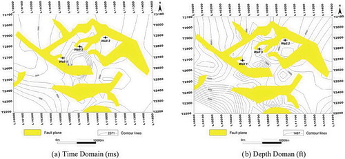
Figure 3. Isopach map on time (ms) and depth (ft) domain.
The Akata Formation (Miocene to Recent) is estimated to be 7000 m thick (Doust & Omatsola, Citation1990; Oladotun, Olugbenga, Chukwudike, & Olatunji, Citation2016). They Akata, Agbada, and Benin Formations are inter-fingering lithofacies equivalent which represent prodelta, deltaic front and delta top environment, respectively. Doust and Omatsola (Citation1990) suggested that the distribution of petroleum is likely related to heterogeneity of source rock type. Petroleum in the Niger Delta is produced from sandstone and unconsolidated sands predominantly in the Agbada Formation. The Tertiary Niger Delta development was a function of subsidence and sedimentation rate which alternates based on sea level rise and fall that results in progradation, retrogradation and aggradation deposition.
The Agbada Formation (Eocene to Recent) is the major petroleum-bearing unit that is estimated to be 3700 m thick and it is the deltaic portion of the Niger Delta stratigraphic sequence. These siliciclastic sediments are deposited in deltaic front, delta top-set, and fluvio-deltaic environment. Generally, the sand to shale ratio decreases with increase in depth. The structures identified within the Niger Delta Petroleum Province are found below the Benin Formation (Over 2000 m thick) and they include Shale diapirs, roll-over anticlines, growth fault, back to back and steep dipping closely spaced flanks faults (Evamy et al., Citation1978; Xiao & Suppe, Citation1992).The growth faults present had been described by Shell-BP and Gulf Nigeria geologist, Short and Stauble (Citation1967), Avuru, Adeleke, and Gbadamosi (Citation2011), Merki (Citation1972), Weber and Daukoru (Citation1975) and Evamy et al. (Citation1978). The characteristics of the reservoirs in the Agbada Formation are controlled by depositional environment and the depth of burial.
The stratigraphic evolution of the Tertiary Niger Delta was described by Evamy et al. (Citation1978), and Doust and Omatsola (Citation1990) further described its stratigraphic column while Avbovbo (Citation1978) produced the structural map of the Niger Delta formations. Petters (Citation1991) described the sequence stratigraphic building blocks of the Niger Delta Basin succession to have 11 third-order sequences which are mainly Transgressive System tracts (TST) and Highstand System tracts (HST). The planktonic foraminifera that were recovered from some regional marker shale suggest that the third-order transgressive pulses occurred during Late Paleocene, Early Eocene, Late Eocene, Late Oligocene to Early Miocene, Late to Early Miocene, Middle Miocene, Late Miocene, and Pliocene. The Transgressive System Tract (TST) was followed by fluviomarine laminated silt, sand and clays which graded into lower to upper shoreface sand and coastal plain deposits (Oresajo, Adekeye, & Haruna, Citation2015; Petters, Citation1991; Ukpong & Anyanwu, Citation2018).
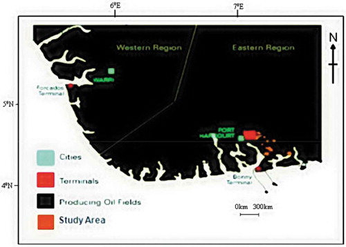
The study area is located in onshore Niger Delta Petroleum Basin (). The Niger Delta is situated in the Gulf of Guinea in equatorial West Africa between Latitudes 3°N and 6°N and Longitudes 5°E and 8°E. The sedimentary basin of the Niger Delta occupies a larger region than the geographical extent of the modern delta constructed by the River Niger to River Benue drainage systems.
Figure 1. Location map of Niger Delta showing study area.
The aim of this study is to make use of wireline logs, seismic, sidewall core description and biofacies data to determine the structure and stratigraphy of Banghan field. The understanding of the structural and stratigraphic framework by this study provides insights to the structural and stratigraphic evolution on retention or non-retention of hydrocarbons which is vital in hydrocarbon exploration and exploitation decision-making for this study area.
Materials and methods
The data set analyzed in this research includes seismic, well logs, core description, and biofacies data. Seismic data () were analyzed to produce structural map and it was tied to well data, core interpretations, and biofacies data to identify depositional sequences.
Figure 2. (2a) Seismic Base Map of Banghan Field (2b) Seismic section along with in-line 10920.
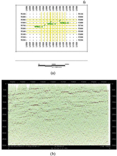
Horizons with good lateral reflection continuity and faults were picked and mapped manually on each line and transverse profile of the entire 2D seismic reflection survey sections of the study area. The horizons picked correspond to depositional sequence boundaries and seismic sequences. Seismic checkshot data were analyzed to provide time-depth match (time in milliseconds and depths in feet) which aided production of 3D isopach maps. The biofacies data were used in dating chrono-surfaces within the study area and lithologic units were delineated using gamma ray logs (Schlumberger, Citation1972). Chrono units were inferred base on retrogradational, aggradational and progradational stacking patterns of gamma-ray logs (Bertram et al., Citation1996).
Results and discussion
The field is intensely faulted and its fault assisted closures are revealed dominantly in the Northern area of the field. These closures correspond to the crest of the rollover structures which serve as possible trapping mechanism of the reservoir.
The lateral transmissibility of the growth faults may be controlled by the extent and nature of clay smear, cataclastic shear zone, hydrodynamics and the relative position of fault to hydrocarbon kitchen. The growth fault () dip ranges from 32° to 71° and it decreases towards the base of the fault. The growth fault presence decreases towards the surface. The growth faults throw ranges from 10 to 91 m with dominant synthetic growth fault trending NW-SE while the subsidiary and antithetic growth faults trends NE-SW. These faults will result in the compartmentalization of hydrocarbon reservoirs within this study area.
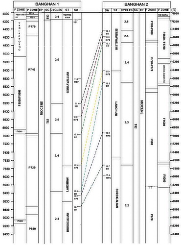
The biofacies analysis of well data shows that the lithologic units found within Banghan field are Miocene in age (). The ages range from Burdigalian to Tortonian and the study area had undergone at least six cycles of deposition within two super cycles (). The maximum flooding surfaces are defined based on marker shales () identified and when tied to the Niger Delta Chrono Stratigraphic chart, their ages were inferred.
Table 1. The ages of marker shale identified within Banghan Field.
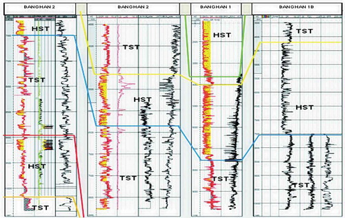
Figure 4. Biofacies Analysis, Chronosurface Dating, and Correlation of Banghan 1 and Banghan 2 Well Data (EP = Epoch; SC = Super Cycles; ST = Stages; SA = Surface Age).
The lithofacies found within this field are bioturbated heteroliths, shales and laminated sandstones. The heteroliths and laminated sandstones are the dominant hydrocarbon reservoir within the study area. The chrono units () are inferred from gamma-ray logs based on retrogradational, aggradational and progradational stacking pattern. The transgressive sequences show increasing shales which are very good hydrocarbon seal because of their permeability and lateral extent. These seals are fundamental and their characteristics control the presence, distribution, absence, and movement of hydrocarbons. Generally, hydrocarbon continuously migrates until it encounters a seal which may be characterized by drainage area, differential geospatial integrity and capacity. The sandstones in the study area are mud supported, laminated with well sorted, fine to medium grey or milky colored grains. The shales were dark grey, silty, slightly calcareous and frangible based on core descriptions.
Figure 5. Banghan 1, Banghan 2 And Banghan 3 Log Correlation Based on Identification of Chrono Units (HST – Highstand System Tract; TST – Transgressive System Tract).
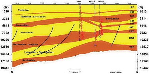
Subsequently, by integrating the results from well logs, biofacies, core description and seismic analysis, a cross-section of the study area showing lithology and stratigraphic sequences at a depth less than 19442 ft (5925.2 m) is generated (). The identified depositional sequences are results of sea level rise and fall and these sediments were deposited in accordance with Walther’s law of facies succession.
Figure 6. Cross Section of Banghan Field Obtained from Sequence Stratigraphic Analysis by Integration of Data Available.
Conclusion
The Banghan field is attributed with syn-depositional growth faults that are common within the Niger Delta Petroleum Province. The growth faults throw ranges from 10 to 90m. The synthetic growth faults trend NW-SE while antithetic and other subsidiary faults trend NE-SW. The field structures show a high tendency to trap hydrocarbon along fault assisted closures which corresponds to rollover crest. The lithologic units in the study area are Miocene in age and the lithofacies found are bioturbated heteroliths, shales, and laminated sandstones. The various maximum flooding surfaces and sequence boundaries identified reveal that the field had undergone at least six cycles of deposition within two super cycles.
Disclosure statement
No potential conflict of interest was reported by the authors.
References
- Avbovbo, A. A. (1978). Tertiary lithostratigraphy of the Niger Delta. American Association of Petroleum Geologist Bulletin, 62, 295–300.
- Avuru, A., Adeleke, V., & Gbadamosi, T. (2011). Unraveling the structural complexity of a marginal field—The Asuokpu/Umutu study. Niger Assoc Pet Explor, 23, 1–4.
- Bertram, G., Emery, D., Griffiths, C., Myers, K., Reynolds, T., Richards, M., & Sturrock, S. (1996). Sequence stratigraphy (pp. 17–41). Oxford: Blackwell Science Ltd.
- Doust, H., & Omatsola, E. (1990). Niger Delta. In J. D. Edwards & P. A. Santogrossi AAPG Memoir 48 Eds., Divergent/passive margin basins (pp. 239–248). Tulsa: AAPG.
- Evamy, B. D., Haremboure, J., Kamerling, P., Knaap, W. A., Molloy, F. A., & Rowlands, P. H. (1978). Hydrocarbon habitat of tertiary Niger Delta. AAPG Bulletin, 62, 1–39.
- Merki, J. P. (1972). Structural geology of the cenozoic Niger Delta, in African geology (pp. 635–646). Ibadan Nigeria: Ibadan University Press.
- Oladotun, A. O., Olugbenga, A. E., Chukwudike, G. O., & Olatunji, A. (2016). Modeling hydrocarbon generation potentials of Eocene source rocks in the Agbada Formation, Northern Delta Depobelt, Niger Delta Basin, Nigeria. Journal of Petroleum Exploration Production Technology, 7, 379–388.
- Oresajo, B. S., Adekeye, A. O., & Haruna, K. A. (2015). Sequence stratigraphy and structural analysis of the emi field,offshore depobelt, Eastern Niger Delta Basin, Nigeria. Ife Journal of Science, 17(2), 395–407.
- Petters, S. W. (1991). Regional geology of Africa. Lecture Notes in Earth Science, Vol.40 Heidelberg: Springer-verlap, p. 156–497.
- Schlumberger. (1972). log interpretation charts. Houston: Author.
- Short, F. C., & Stauble, A. J. (1967). Outline of geology of the Niger Delta. AAPG Bulletin, 51, 761–779.
- Ukpong, A. J., & Anyanwu, T. C. (2018). Sequence stratigraphic implication to hydrocarbon exploration in “beta field”, northern depobelt of the Niger Delta Basin. International Journal of Recent Trends in Engineering and Research, 4, 405–419.
- Weber, K. J., & Daukoru, E. (1975). Petroleum geology of the Niger Delta. 9th World Petroleum Congress Proceeding, 2, 209–221.
- Xiao, H., & Suppe, J. (1992). Origin of rollovers. American Association of Petroleum Geologist Bulletin, 76, 509–629.