
ABSTRACT
The present study has been carried out in Kashmir Basin (KB), NW Himalaya, to determine the relative tectonic activity using morphotectonic analysis, drainage patterns, lineament analysis and geomorphological field observations. Geomorphic signatures in KB indicate that intrabasinal faults have been quite active during the Quaternary time and have played a dominant role in kinematic and structural evolution of the basin. The manifestation of this activity has been recorded by terrain morphology, uplifted river terraces, warped fluvial surfaces, strath surfaces, fault scarps, offset of Holocene sedimentary successions, braided, and offsetted drainage patterns and recent seismic activity in the region. Presence of active mountain fronts; concave, convex, and concavo-convex hypsometric curves; ambiguous stream gradient index and drainage basin asymmetry, elongated sub-basins clearly manifest tectonic influences in sculpting the basin geometry. The presence of NW-SE to NNE-SSW lineaments that generally strike parallel with the major regional tectonic structures (faults) clearly suggest intense deformation zones produced by ongoing regional tectonism. We propose that the techniques employed, the data obtained and the technical interpretations, are potentially useful and may also be extrapolated to similar tectonically active regions.
1. Introduction
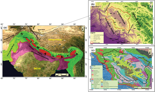
Several Himalayan intermontane basins were formed throughout the Tertiary Period due to hybrid tectonism, where both compressional and extensional tectonic activities controlled their shape and structure (; Burbank & Johnson, Citation1983; Yin, Citation2006). These intermountain basins are filled with sediments derived from adjacent uplifted regions since the Last Glacial Maximum (Kuhle, Citation2005). Throughout the evolution of these basins, changing climatic conditions, differential tectonic processes, varied rate of erosion and deposition significantly influenced and controlled their evolution (Goswami & Pant, Citation2007; Menier et al., Citation2017; Nakata, Citation1972; Starke et al., Citation2017). The study of these basins provides information about the mode of formation, tectonic history as well as geomorphologic processes that controlled their evolution. Several studies (e.g., Ahmad et al., Citation2015; Ali et al., Citation2021; Hooper et al., Citation2003; Kaya et al., Citation2004; Nakata, Citation1989; Philip et al., Citation2006) have applied remote-sensing techniques in geomorphologic analyses to understand the kinematics and active tectonics of different regions. The use of high-resolution satellite imageries and digital elevation models have proven significant for large-scale field investigation within less time and high precision. Besides remote-sensing techniques, geomorphic signatures like active fault scarps, beheaded and offset drainage patterns, several levels of quaternary river terraces and frequent small magnitude earthquakes act as key evidences of Quaternary deformation. The recognition of Quaternary deformation structures is therefore helpful in deciphering ongoing tectonism for understanding the regional landscape evolution. In tectonically active regions like Himalaya, presence of linear geomorphic structures (lineaments/faults) provides significant information regarding the pattern and behavior of landscape evolution (Novak & Soulakellis, Citation2000; Salehi et al., Citation2015; Srivastava et al., Citation2017). The fault-controlled drainage patterns as well as topography in tectonically active regions are important evidences of active tectonics (Hallet & Molnar, Citation2001; Malik & Mohanty, Citation2007; Marple & Talwani, Citation1993) and the shape and pattern of basin drainage suggests relative rate of deformation. The Kashmir Basin (KB), a Neogene-Quaternary synformal intermontane basin, situated ~100 km north of active deformation front presents an ideal tectonic setting for understanding the active tectonics of Himalayan orogenic system (). It preserves past 4 Ma record of Himalayan orogeny, including the sedimentation, tectonics viz-a-viz basin evolution in an actively deforming wedge system.
Figure 1. (a) Map of the Himalaya showing the location the Himalayan accretionary wedge (green), active Himalayan foreland basin (pink), piggyback basins (red). (b) Tectonic map of the Kashmir Himalaya, solid red line indicates Kashmir Basin (KB). (c) Regional geological map of the Kashmir basin and adjoining areas.
In this context, in present study, a detailed investigation of geomorphic indices, drainage patterns, structural features (faults and lineament), and lithostratigraphic analysis have been incorporated to evaluate the tectonic and geomorphic evolution as well as relative tectonic activity of the Kashmir Basin. Integrating these methods together will provide a comprehensive knowledge about the temporal geomorphic evolution of the basin. Hence, the present work has been carried out with an integrated approach using geological, geomorphological, remote-sensing and GIS and extensive field observations to understand the basin evolution as well as relative tectonic activity of this region.
The present work is important in understanding how surface deformation induced by slip on internal wedge faults controls the regional tectonics. The KB is situated nearly ~100 km north of active deformation front, but possess rejuvenated terrain morphology, uplifted river terraces, warped fluvial surfaces, strath surfaces, fault scarps, offset of Holocene sedimentary successions, active mountain fronts, deeply incised valleys, offsetted drainage patterns which reflects higher tectonic activity in this region. Due to lack of comprehensive active tectonics studies in this region, present study is very vital for understanding the active tectonics, and role of internal wedge structures in basin evolution.
2. Geology and tectonic setup of Kashmir Basin
Kashmir Basin (KB), an intermontane piggy back basin evolved in Neogene-Quaternary time, displays major tectonostratigraphic features striking almost parallel to the regional orientation of arcuate fold and thrust belt of NW Himalaya. Regionally known as Kashmir-Hazara Syntaxis, where the Himalayan fold-thrust belt takes a hairpin bend in NS direction. Towards east of the Kashmir-Hazara Syntaxial bend the Himalayan mountain range bifurcates into two mountain ranges running parallel to each other for nearly >100 kms sculpting the oval shape of KB. The KB is a classic example of orogen-parallel compressional zone with synclinal architecture composed of crustal scale fold and thrust zones with recurrent seismicity. The basin is spread over an area of 13,605 km2, characterized by typical nappe type structure bounded on the south and north by steeply dipping Panjal Thrust and gently dipping Zanskar Thrust, respectively (Bhat, Citation1982; Jaiswal et al., Citation2009). This region is marked by vast relief variation, complex geological setting with rock formation of Precambrian to Cenozoic in age (Thakur & Rawat, Citation1992; ). The basin comprises well-developed stratigraphic successions of Palaeozoic, Mesozoic and Cenozoic rock formations scattered throughout the basin and its peripheries. The KB is filled by ~1300-m-thick unconsolidated sediments comprising clays, sands, silts, gravels, and conglomerates with occasional lignite beds known as Karewas. These sediments provide substantial evidences of the formation and evolution KB (Bhatt, Citation1975; Burbank & Johnson, Citation1983), where differential and sporadic tectonic events directed the sedimentation pattern (Agarwal & Agrawal, Citation2005; Burbank & Reynolds, Citation1984).
3. Materials and methods
In present study using morphotectonic analysis, different geomorphic indices (mountain front sinuosity (Smf), hypsometric curve and integral (Hi), stream gradient index (SL), drainage basin asymmetry (AF) topographic asymmetry (T), drainage basin shape such as elongation ratio (Eb), bifurcation ratio (Rb)) were evaluated at sub-basin level to depict the role of tectonics at large-scale in landscape evolution and understand the local as well regional structures that control the evolution of the basin. Mountain front sinuosity is computed by: Smf = Lmf/Ls, where Lmf is mountain front length at piedmont and Ls is straight length of front. The hypsometric integral (Hi) was calculated as: Hi = (HMean – Hminimum)/(Hmaximum – Hminimum) where the maximum and minimum elevation was directly taken and mean elevation was computed by averaging more than 50 elevation values uniformly distributed in the sub-watersheds. Stream length gradient index (SL) was computed by: SL = (ΔH/ΔL)/L, where ΔH and ΔL are the difference in height and length between two points and L is the total length, measured from the divide to middle of that two points. In the study area, the SL index was calculated in all 14 sub-watersheds along the main stream. The asymmetry factor (Af) is calculated as: Af = 100 (Ar/At), where Af is the asymmetry index, At is total drainage basin area and Ar is drainage basin area to the right side of master stream (looking downstream). The Transverse topography symmetry (T) is calculated as: T = Da/Dd, where Da = distance from the midline of the drainage basin to the midline of active meander belt, and Dd = distance from midline of the basin to the drainage divide. The Basin elongation ratio (Eb) is calculated as: Eb = 2√((Ab⁄π)/lb), where Ab = diameter of a circle of the same area as that of the basin, and lb = length of the basin measured from its mouth to most distant point on the watershed. The Bifurcation ratio (Rb) is calculated as: Rb = Nu/Nu+1, where Nu = sum of streams of given order and Nu+1 = sum of streams of subsequent higher order. The Form factor (Ff) is calculated as: Ff = A/L2, where A = the total area of the basin and L2 is square of the basin length. Toposheets in digital format at 1: 50,000 scale and Digital Elevation Model (DEM 30 m) were used to extract geomorphic indices. These toposheets were georeferenced in Arc GIS 10.3 to calculate different geomorphic indices for morphometric analysis and morphological characterization. The calculated geomorphic indices were then used in accessing the active tectonics of the study area.
The drainage map of KB was prepared manually (from toposheets) as well as from ASTER DEM in Arc GIS 10.3 software so that missing links in manual digitization were filled. Then, stream ordering was performed following (A. N. Strahler, Citation1969) approach. Different patterns of drainage were analyzed to determine the role of active tectonics in configuration of shape, orientation, and geometry of different drainage systems across the KB and distinguish between lithologically and structurally controlled drainage patterns.
In present study, we implemented lineament extraction algorithm (after Han et al., Citation2018) for delineation and extraction of lineaments from satellite imageries (Landsat ETM (2001) with 30 m resolution, Landsat ETM+PAN (2010) 15 m resolution and Landsat 8 OLI (2013) with 15 m resolution) and Digital Elevation Model (CARTOSET-1 DEM; 2.5 m resolution). These imageries were first pre-processed and geometrically rectified. Using Principal Component Analysis (PCA), the suitable band combination of images was chosen for extraction of lineaments. Also False Colour Composite (FCC) image was carried out for different bands of Landsat ETM, and it was found that green (band 2), red (band 3) NIR (band 4) were most suitable for lineament extraction/mapping. To refine edges in the DEM and Landsat OLI high-pass Gaussian filtering was applied. This filtering for edge enhancement techniques supports for preservation of high frequency elements in the satellite imageries. This process helped in creating linear boundaries on the basis of noticeable vector sum superposition features of the edge points using tensor voting. The lineaments were differentiated from both linear features like mountain ridges, rivers as well as manmade features like roads, field boundaries, railway tracks. This leads to determination of possible structurally oriented and tectonically evolved lineaments. The orientation of the possible lineaments was calculated for statistical analysis and for plotting on Rose diagram. The subsequent lineament map was correlated with the existing lineament map of Kashmir valley (Ganju & Khar, Citation1984). In the end, Hough Transform (HT; Wang & Howarth, Citation1990) filtering technique was used to examine the edges and map/extract the lineaments. Arc-GIS 10.3 and MATLAB 2016 software were utilized for lineament mapping, determine their orientation, distribution and concentration as well as their role in regional tectonics and geomorphology.
Detailed field investigation was carried around and across the basin to document the regional geomorphological character of the basin. Different sites were chosen which were demarcated by remote-sensing techniques which were the locus of quaternary deformation. Both hard rocks and soft rock structures were observed to document the influence of ongoing tectonism in and around the basin. Different structures were observed which include highly deformed and folded rock sequences around the basin. The Quaternary Karewa sediments were intensively mapped and presence of different structures like deeply entrenched valleys, paleo-channels, strath terraces, unpaired river terraces small-scale thrust and normal faults, soft sediment deformation structures, offset drainage patterns etc. were observed at different locations. These evidences support the influence of recent tectonic deformation in landscape evolution and high rate of quaternary seismicity.
4. Result and discussion
4.1. Morphotectonic analysis
Morphometric techniques, based on mathematical assessment and measurement of the structure and form of existing landscapes of any region, provide clues of diverse physiognomies of basins, like, nature of erosion and deposition, uplift rates and subsequently trend of landscape evolution (Bull, Citation2008; Keller & Pinter, Citation2002; Pike & Wilson, Citation1971; AN Strahler, Citation1952). This study therefore provides significant evidences about the role of the particular tectonic structure responsible for landscape evolution.
4.1.1. Mountain front sinuosity (Smf)
In present study, the Smf values were calculated for 114 mountain front segments (; ) along the different sections of the KB (sub-basin wise) and these values were validated by ground truth during field investigations. The average Smf values from each sub-basin were taken into consideration while inferring the dominant factor responsible for the evolution of sub-basin. The results suggest that the deposition of Quaternary to Recent sediments along the mountain fronts infer recent active tectonism in the form of distorted alluvial fans, intensely incised rivers and rejuvenated drainage pattern. Most of the mountain fronts, show dendritic to sub-dendritic (North and southern portions) and trellis (southern portion) drainage patterns along different sections with distinctive deeply incised V-and U-shaped valleys. On the southern margin of the basin different geomorphic features are present in the form of strath terraces, offset drainage and deformed alluvial fans. The Northern or Greater Himalayan side of the basin, displays relatively moderate mountain fronts with an average Smf 1.4. The mountain fronts on the NE and SW portions of the KB show tectonically active mountain fronts (average Smf = 1.19) as compared to less active northwest mountain fronts (average Smf = 2.25). The interaction among the several landforms further highlight the overall moderate-to-high rate of tectonic activities, with higher glacial deposits and subsequent erosion in sculpting the geometry the mountain front.
Figure 2. Mountain front Sinuosity (Smf) of different mountain front segments in Kashmir Basin.
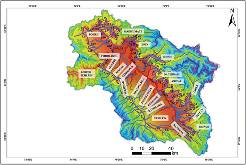
Table 1. Calculated geomorphic indices for different sub basins of Kashmir basin.
4.1.2. Hypsometric integral (Hi)
The calculated Hi values vary between 0.51 and 0.64 for all the sub-basins (). The trend of the determines the tectonic influence on the basin. The different categories of Hypsometric curve (concave, convex and concavo-convex) describe the rate of tectonic influence (concave: tectonically active region, convex: moderately active with excessive erosion and concavo-convex: hybrid character). Pohru, Dachigam, Aripal, Bringi, and Sandran rivers display convex type of Hi profile, whereas Sindh Madhumati, and Erin rivers display concave nature. Conversely, Doodhganga-Shaliganga, Kuthar, Ningal-Gundar, Rambiara, Sukhnag-Ferozpur, Veshaw, and Romushi rivers display hybrid character with convex in lower portions and concave in upper portions, while Lidder River displays mixed character of convex-concave-convex Hi curve. The Hi of northeast flowing, namely, Doodhganga, Sukhnag-Ferozpur, Shaliganga, and Ningal-Gundar originating in Pir-Panjal range is > 0.60, inferring probable simultaneous evolution of these rivers and largely dominated by similar tectonic forces responsible for evolution of these basins (, ).
Figure 3. Hypsometric integral curves of the basins (Where A = total surface of the basin, a = surface area within the basin above a given elevation h and H = highest elevation of the basin).
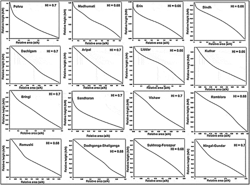
Figure 4. Continued.
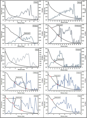
4.1.3. Stream Gradient Index (SL)
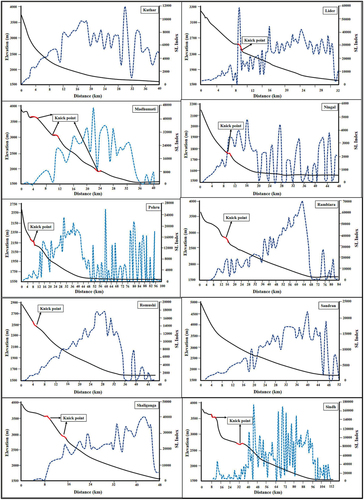
The higher SL values show convex profiles and are observed in areas where rivers pass over the hard rocks indicating higher tectonic activity. Similarly, low SL value shows convex profiles and is observed in areas where rivers pass over softer and less-resistant rocks indicating relatively low tectonic activity (Hack, Citation1973; Keller & Pinter, Citation2002). High values of SL ratio in terrain with underlying soft rocks are also an indication of recent tectonic activity. Usually in homogenous lithological surfaces, the SL values decrease downstream. In present study, the SL values increase downstream indicating control by recent tectonic activity (, ). The NE flowing streams originating in Pir Panjal range (southern side of basin) show very irregular SL plots, indicating highly deformed river course. This can be due to the presence of numerous faults in this region (2Citation015; Ahmad & Bhat, Citation2012, Citation2013; Ahmad et al., Citation2014; Madden et al., Citation2011, Citation2010; Shah, Citation2013, Citation2015) controlling the overall river morphology. SL curves of the observed sub-basins show presence of Knick-points at different locations along their river course suggesting possible structural disturbances due to presence of faults cutting across their course. These anomalies can be attributed to rivers along the southern front of basin passing across Balapur fault (Ahmad et al., Citation2015).
Figure 4. Longitudinal profiles and SL of Aripal, Bringi, Dachigam, Doodhganga, Erin, Ferozpor, Gondar, Kuthar, Lider, Madhumati, Ningal, Rambiara, Romushi, Pohru, Sindh, Sandran, Veshaw, Shaliganga, Sukhnag, Vijay-Dhakil rivers.
4.1.4. Drainage basin asymmetry (AF)
Comprehensive differences were observed in AF values for most of the sub-basins. In present study, the obtained AF values vary between 79.33% (Bringi) and 21.40% (Erin; ). The results suggest that seven basins (Bringi, Sindh, Ningal, Veshaw, Vijay-Dhakil, Sukhnag, Ferozpor) are tilted towards right side, while seven basins (Pohru, Aripal, Erin, Kuthar, Lidder, Rambiara, Sandran) are tilted toward left side and three basins (Doodhganga, Madhumati, Romushi) are slightly tilted towards right. Sub-basins that are highly tilted show gentle to-strong asymmetrical character, while as some sub-basins are symmetric in nature. The characteristic feature of all asymmetrical basins is represented by deformed unpaired river terraces. These interpretations are well supported by the field investigations like development of unpaired river terraces, the presence of longer tributaries to the tilted side of the basin and modified/shifted trunk streams opposite to the uplifted part of the basin. Rivers right-side tilted with AF>50 show shorter length tributaries on right side while as left tributaries are greater in length. Similar pattern is observed in left tilted rivers with left tributaries greater in length than right. While as in symmetrical basins the tributary lengths don’t vary much. Also the shifting of the Jhelum River toward north further justifies the north side tilting of KB because of uplift of PPR along with greater length of streams originating on this side.
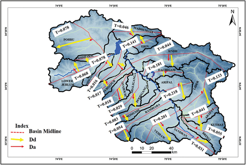
4.1.5. Transverse topography symmetry (T)
The T values were calculated for 19 sub-basins (; ). The T value varies from 0.016 to 0.218. The highest T value was found for Aripal basin (0.218) and lowest for Ningal basin (0.016). The overall results show low tilting of the basins indicating low tectonic influence. However, the regional tilt of the Kashmir basin is toward north due to constant uplift of Pir Panjal range which is indicated by nearly 40 dip of Karewa sediments, that indicates regional tilting rather than local tilting.
Figure 5. Topographic symmetry factor (T) (where Dd = is the distance between the mid-line and the main river and Da = is the distance between the mid-line and the boundary of the drainage basin).
4.1.6. Basin elongation ratio (Eb)
In present study, Eb ranges from 0.10 to 0.19 (). The results specify that all of the sub-basins are elongate and largely influenced by recent tectonics. Some basins (Pohru, Erin, Aripal and Kuthar) show higher Eb values suggesting that these basins are moderately impacted by tectonic activity. Sub-basins mostly on the Pir Panjal side are highly elongated suggesting higher tectonic disturbances. While as on northern side of sub-basin Sind shows very low Eb values inferring higher tectonic disturbances, this is supported by the presence of numerous tectonic structures (faults, triangular facets, deeply incised channels, uplifted terraces) in this sub-basin parallel as well as cutting the main river.
4.1.7. Bifurcation ratio (Rb)
Based on bifurcation ration the sub-basin Sandran sub-basin shows tectonically active nature with Rb = 4.5 while as the Pohru sub-basin with Rb = 2.15 shows less tonic influence (). The higher values of Rb toward the south and the low values toward the north of the Jhelum River indicate that sub basins toward the south are more active than the sub basins toward northern side of the basin. This can be attributed to presence of Balapur fault and associated structures, along the southern margin of the basin. The sub-basins toward north are devoid of such important structures and are therefore relatively less active.
4.1.8. Form factor (Ff)
The Ff values vary from 0.18 to 0.69 for the different sub-basins (). The Pohru and Erin sub-basins with high Ff with circular shape possess low tectonic activity, whereas elongated basins with low Ff values possess high tectonic activity (R Bali et al., Citation2012; BS Bali et al., Citation2016). The lowest values of the Ff of the sub-basins from the Pir Panjal side indicate the basins are highly elongate and tectonically more active than the sub-basins from the Great Himalayan side. The Pohru sub-basin possess highest Ff (0.69) with almost circular in shape shows low tectonic activity while as the Rambaria sub-basin possess low Ff (0.18) is highly elongated in shape and possess high tectonic activity.
4.2. Drainage characteristics
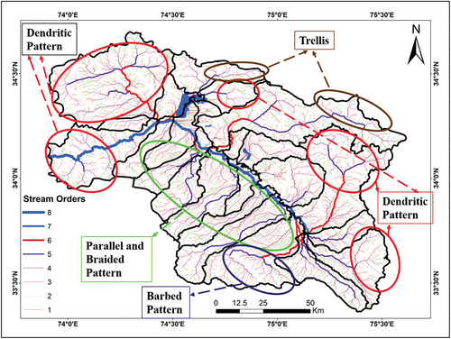
The drainage pattern of KB is highly elusive. The KB is a geologically young with high of tectonic influence and activity due to continuous Himalayan uplift. This rapid uplift has modified the drainage pattern in the past (Basavaiah et al., Citation2010; Burbank, Citation1983) and is currently controlling their shape, structure and pattern. Hard rocks mainly dominate the headwater/source region while as after entering the basin they pass over homogenous and soft rock lithologies, i.e., Karewas and recent flood plains. The KB is drained by a by single major river, the Jhelum River. It traverses through the center of the basin and is fed on both sides by several tributaries along its course and drains the basin through narrow gorge at Baramulla. The river is fed on north by Bringi, Kuthar, Aripat, Lider, Aripal, Dachigam, Sind, Erin, and Madhumati, while as on south it’s fed by Sandran, Veshaw, Rambiara, Romushi, Doodhganga, Shaliganga, Sukhnag, Ferozpor, Ningal, Garzan, and Vijay-Dhakil. The Pohru and Mawar joins the it from east. The Jhelum river is more shifted toward north, closer to Greater Himalayan side due to continuous uplift of PPR side. The river flows mostly on soft rocks and is characterized by considerable meandering along its course. This is due to very gentle slope of river course in the valley and the presence of unconsolidated sediments along the river course. On northern side (Greater Himalayan side), the streams flow towards south and pass mainly through hard rocks for most of their river course before merging with Jhelum River. These rivers are mainly lithologically controlled. Among these Lider and Sind rivers show upto sixth-order streams. These rivers are perennial in nature with high gradient. Smaller rivers (Madhumati, Erin, Dachigam, Aripal, Aripat, Kuthar, Bringi and Sandran) show upto fifth-order streams. Most of these rivers show much entrenched narrower river course with highly incised steep valleys and gorges ().
Figure 6. Observed different types of drainage patterns in the Kashmir basin.
Much of the difference and evolution is found on the north flowing river systems. The river basins on this side are elongated and with distinctive drainage divides in higher reaches and anomalous in lower portions due to inter-basin crossover of rivers. These rivers mostly pass over soft rock terrains (Karewa and river Alluvium) for most of their river course. These originate in the higher elevations of PPR and flow toward north. Their river course is very different than the south flowing rivers. They have steep to gentle slopes and presence of various Knick points along their river course (Ahmad et al., Citation2015). Except Veshaw (seventh-order streams) most of these rivers show upto fifth-order streams. However, these rivers show deflection and abrupt meandering at different locations, which can be attributed to structural control (presence of faults).
4.2.1. Drainage patterns
In KB, various styles of drainage patterns are present like dendritic, trellis, radial, parallel, rectangular, and barbed patterns (). Dendritic drainage pattern is widely present with most low-order tributaries meeting the higher at less than 90°. This type of drainage is observed where lithology is homogenous and where lithology controls the drainage pattern with less structural control. Both antecedent as well as superimposed dendritic patterns are found in less resistant rocks as well as flat lying horizontal sedimentary, massive igneous, and metamorphic rocks at different locations of the basin. This type of drainage is also found in folded and tilted rocks that can be attributed for superimposition of the drainage post folding and tilting of beds. The Pohru, Erin, Lider basins as well as higher elevated regions shows this type of drainage pattern indicating less structurally controlled drainage patterns. Sub-trellis to trellis pattern is observed in Madhumati and Sind basins. In these basins, a system of parallel-sub-parallel streams flow along the elevated linear ridges. In these areas the major streams are found abruptly bending at 90° while crossing the structural obstructions and low-order streams (first order) flow perpendicular with respect to main stream, however middle-order (second and third order) streams are mostly parallel to sub-parallel with respect to each other. These drainage patterns suggest noticeable structural control of most stream courses. The trellis pattern is mostly fault-controlled where by segmented and layered fault splays produce alternating bands of resistant and weak rocks. In KB, the trellis drainage patterns are found closely associated along Himalayan thrust sheets. The thrust sheets are folded and refolded producing alternate layers or bands of rocks suitable for the formation of trellis drainage. In the upper reaches of Sindh and Madhumati sub-basins, the presence of offset and linear drainage lines also suggest structural control.
Most of the southern basins on Pir Panjal side show parallel drainage pattern. The basins are highly elongated with deeply incised valleys both in hard rocks as well as in Karewa sediments. The rivers flow irregularly with broad and braided pattern with tributaries mostly showing cross-over trend in lower portions of the basin. In the Veshaw basin, the Kandai Kol tributary show barbed pattern flowing in opposite direction and take a hair pin bend before joining the main Veshaw river. The presence of paleo-channel, strath terraces and unpaired river terraces in Veshaw river near the Tangmarg village suggest that the basin has been uplifted and structurally controlled. The same features are observed in Rambiara, Doodhganga, Romushi sub-basins indicating regional/local uplift and structural controls.
The Rambiara basin shows considerable amount of rejuvenated streams with braided bar deposits. Three fault splays representing surficial expressions of Balapur fault has produced beheaded streams (). The Rambiara river near Balapur village has laid down ~500 m wide braided bar in the middle of the channel due to dissection of this river by Balapur fault uplifting the northern segment causing damping and deposition of river sediments. The Balapur fault extends through most of the southern sub basins showing significant geomorphic expressions (Ahmad et al., Citation2015). In Doodhganga and Shaliganga sub-basins, the Balapur fault branches into two sections one moving towards the east while (Balapur fault) as the other one (Raithan fault) traverses towards northeast (Yousuf and Bukhari. Citation2020b). The presence of uplifted strath terraces, dissected scarps and emergence of new streams suggests that these splays are tectonically young and active.
Figure 7. (a, b) Showing drainage modifications by Balapur fault and Raithan Fault along the southern portion of Kashmir basin. Beheaded streams, offset drainage and emergence of new streams are observed along the strike of the faults. (c) Showing traces of Baramulla-Loridor fault (Ahmad et al., Citation2014) or Hayatpor-vatnu fault (Ahmad et al., Citation2015) and deflection in drainage produced by the fault.
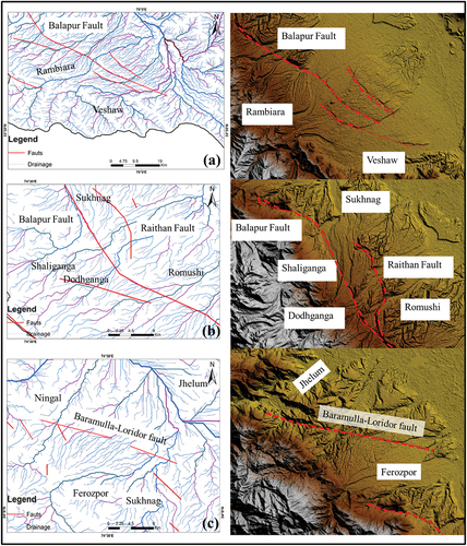
The Ferozpor, Ningal, and Sukhnag sub-basins are dissected by Baramulla-Loridor fault (Ahmad et al., Citation2014) or Hayatpor-vatnu fault (Ahmad et al., Citation2015). This fault has been considered as source fault of 1885 earthquake (6.8 Mw; Ahmad et al., Citation2014; Shah, Citation2015) and has produced a nearly 3 m scarp (Bilham, Citation2019) during 1885 earthquake. The drainage pattern in this region clearly exhibits structural control with most parallel tributaries (). The streams follow the observed fault creating an offset drainage patterns.
4.3. Lineament mapping of Kashmir Basin
The lineaments from different satellite imageries are mostly oriented along NW-SE to NNW-SSE direction (). The extracted lineaments are dense and short showing very low lateral continuity might be due to disparity in the pixel values in satellite imageries as well surface modification by anthropogenic activities. Most lineaments are clustered in regions dominated by large topographic variation, along the boundaries of linear ridges and valleys. However, in the plain regions (central part of basin), the lineaments density decreases which is the result of low topographic variations with plainer topography covered by thick river and alluvial deposits. Most of the lineaments are parallel to the major thrusts present in NW Himalaya. The regularity in orientation of the observed lineaments towards the regional structures suggest that these structures are controlled and formed by ongoing NS directed compressional stress regimes. The concentration and distribution of lineaments suggest that past tectonic activities have substantially deformed this region forming these linear structures. Most of the extracted lineaments are concentrated along southern part of the basin. Furthermore, some NS trending linear features were also extracted. These long and sporadic features were mainly observed in the northern part of the KB along the boundaries of river valleys and mountain ridges. Although variation in image resolution caused overlapping of the lineaments but the direction, concentration and orientation of the observed lineaments fit well with the orientation of regional fault systems.
Figure 8. (a) Lineament map of Kashmir Basin. Inset shows that the orientation of the lineaments using rose diagram analysis. (b) Showing the relation between actual fault traces with the determined lineament map of Kashmir basin. The lineaments mostly follow the trend and orientation of the faults present within this region.
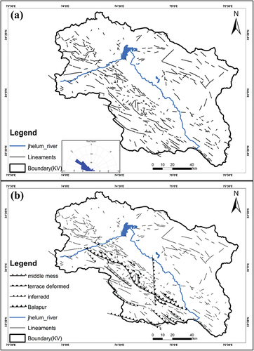
We analyzed the azimuth and distance of extracted lineaments in order to correlate these features with existing geomorphological features to understand whether there is any link and correlation between the lineaments (identified in this study) and the faults present in this region delineated and validated by previous studies (Ahmad et al., Citation2015; Ali et al., Citation2021; Ganju & Khar, Citation1984). We found a good correlation with most of the existing faults (). The present study was also useful in determining various other possible faults in this region validated by ground truth. These are the E-W, NW-SE, and NE-SW fault systems present in southern side of KB. This part of the basin is supposed to be subjected to severe tectonic activity that caused formation of numerous faults as well as linear structures (Ahmad et al., Citation2015; Madden et al., Citation2011, Citation2010; Nakata, Citation1972). During field investigation, a large fault scarp at Yusmarg was identified that displace the river courses and cut across the Quaternary terraces indicating that the observed fault has recently slipped after the last glacial maximum (22–17 ka).
4.4. Geomorphological observations
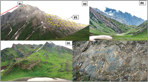
The Kashmir basin occupies an oval-shaped depression in the NW Himalayan segment. It is surrounded on all sides by lofty mountain ranges with Greater Himalayan range towards north and PPR towards south. These ranges consist of south propagating thrust sheets. The Zanskar thrust on the north consists of highly deformed zone known as Zanskar Shear Zone (ZSZ). This zone is believed to be seismically inactive with no significant slip along the faults in Quaternary times. This zone consists of numerous large folded structures both anticlines and synclines (). These large folded structures are resultant of Indo-Eurasian collusion, where NS oriented compressional stresses has resulted in the thickening of the crust in the form of these large-scale folded structures. Such intensive folding suggests poly-phased deformation. Most of the folds are oriented in an EW direction, parallel to the Himalayan arc and represent primary folds (F1) or phase I folding of Himalayan system, representing first phase of Himalayan deformation. However, these folds are refolded or superimposed by secondary set of folds (F2). This suggests complex convergence with varied paleo-stress directions caused refolding of the already folded rocks. The secondary folds are oriented in NS direction lying perpendicular to the primary folds. The secondary folds (F2) have refolded the primary folds (F1) limbs as well as their axial surfaces representing second phase of Himalayan deformation (). These folded structures are key evidences to the overall Himalayan convergence and hold key evidences of crustal shortening. Small microfolds (3–10 cm) are widely present all over this region suggesting intensive deformation phases and over all absorbance of regional shortening in the form of folding ().
Figure 9. Different folded structures observed on the Greater Himalayan side of the basin. (a) represent the large primary folded (F1) with superimposed secondary folded structures, (b) large scale folded limbs formed of alternating beds of Triassic limestone, Phyllites, Siltstone etc., (c) Intensively folded rock formations branching as Y shaped folded, and (d) small scale folds formed in phyletic rocks consisting small quartz veins representing folding at microscopic level.
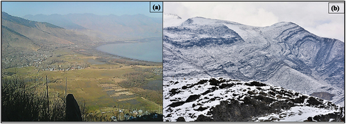
The northern front of the basin bordering the Greater Himalayan side, inside the basin, has intensively folded rock sequences. These EW trending folds lie all along the foot hills forming numerous smaller valleys as synclines and mountain ridges as anticlines. One such example is Wular syncline () that forms the depression or bowel-shaped syncline occupied by Wular lake. Adjacent to this syncline lies the Wular vintage anticline, a south plunging anticline in the form of a small ridge between the Wular and Mansbal lake. A large anticline lies almost next to the Mansbal lake comprising folded Triassic-Jurassic Limestones (). These continuous anticline and syncline structures continues along the whole northern front of the basin and terminate along the Lider anticline at the southern extremes of the basin. All these folds depict secondary folding in an EW direction representing complex stress regimes with complex tectonic evolution. The basin is narrowed at both the extremes by tightly folded rock sequences (Yousuf & Bukhari, Citation2019).
Figure 10. The folded rock sequences along the northern front of the Kashmir Basin. (a) Wular syncline (b) Intensively folded rock sequences at Mansbal area.
On the south of PPR lies an imbricate zone of crustal scale thrusts propagating toward south. Immediate south to the basin lies the seismically inactive MCT that has uplifted the Panjal traps and overthrusted them over Lesser Himalayan sequence. This sequence in turn is thrusted over Miocene rocks, the Shiwaliks, along MBT, that is also seismically inactive. However, south of MBT lies segmented Medlicott-Wadia thrust (MWT), that is seismically active and deforming quaternary deposits and uplifting Shiwalik molasse and thrusted them over quaternary deposits of Indo-Gangetic plains (Gavillot et al., Citation2016). Both MCT and MBT show no quaternary slip although has severely distorted and deformed the older rock sequences ().
Figure 11. Intensively deformed rock formations on the southern front of Kashmir basin. (a) MCT exposure in Uri Kashmir, contact between green schist and marble (b) tightly folded and refolded Limestones, (c and d) large scale folded interbedded red sandstone and limestone at Uri Baramulla close to MCT.
Regions comprising uniform, unconsolidated sedimentary deposits with higher erosion rates hardly preserve fault surface expressions and pose difficulty in identification of active faults (Jaiswal et al., Citation2009). However, in such regions, investigation of geomorphological features provides important clues and markers related to role of ongoing tectonism and presence of buried faults. KB is filled with unconsolidated Quaternary sedimentary deposits (Karewas) that are overlain by recent and younger alluvium deposits. The region consists uniform lithological setup with rapid erosion due to humid and arid climatic conditions that have greatly altered the surficial expressions of active faults. Recent geological investigations in this region has provided some clues of surficial expression of active faults across the different parts of the basin (Ahmad et al., Citation2015; Bilham, Citation2019; Madden et al., Citation2011, Citation2010; Shah, Citation2013, Citation2015). The attendance of tilted fluvio-lacustrine Karewa deposits and several fault segments that vertically offset these quaternary deposits suggest that faults present have been quite active during the Quaternary and recent times in the region (Ahmad & Bhat, Citation2012, Citation2013; Yousuf and Bukhari, Citation2020a). One of the major studied out of sequence fault inside KB is Balapur Fault (BF), a ~ 110 km long fault segment traversing along the southern part of basin with prominent surficial expressions (Ahmad et al., Citation2015; Madden et al., Citation2011, Citation2010). The geomorphic expressions of the fault are largely visible with development of ~30 m scarp along the strike of this fault. BF has distorted numerous strath terraces of north flowing rivers in southern side of KB and triggering significant tilting of the KB. Paleoseismological evidences of BF has shown that BF has slipped four times in past 40 ka (Madden et al., Citation2011) with most recent slip around 1 ka ago (Madden et al., Citation2011, Citation2010). South of the Raithan, the Doodhganga river section traverses another fault, the Kolbug Fault (reverse fault), causative of 1963 (5.3 Mw) Budgam earthquake (Ahmad et al., Citation2015; Yousuf et al., Citation2020). Haiyatpur-Watnu fault system represents another major structure inside the basin. The location and the length (~54kms) of this structure exactly matches the 1885 Mw 6.8 earthquake (Ahmad et al., Citation2014, Yousuf and Bukhari, Citation2020b). Bhat (Citation1982) proposed a deep-seated blind fault with in the basin passing in an EW direction along the Jhelum river.
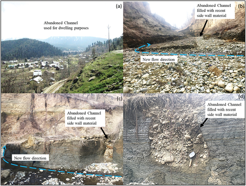
Continuous uplift and tectonism not only reshapes the lithological and structural setup but also severely deforms and distorts the drainage patterns of any region. One such example is the change of the river course producing abandoned channels or paleo-channels. Palaeochannels are important evidences in understanding fault movements, paleo flow directions, response of river systems to climatic changes etc. causing deviation in river courses as well as resulting in formation of abandoned channels. Such paleo-channels provide important clues for ongoing tectonism and regional tilting of the basin tectonics on drainage and landscape evolution (McCalpin, Citation2009). Most palaeochannels form due to significant changes in tectonics, climate and even sea level fluctuations. In Himalayan region, the presence of such palaeochannels reflect large tectonic deformation and active fault movements in Quaternary time causing major shift and deflection of the river courses (Seeber & Gornitz, Citation1983). The KB has numerous such abandoned channels inferring Quaternary tectonic disturbances (). Most of the tributaries of the Jhelum river have shifted their river course abandoning their initial flow directions formed new river courses. Such features can be attributed to structural control due to presence of faults cutting across and damming the original course. The rivers start eroding to less resistant rocks and generate their new course. Most of these abandoned channels have been utilized for construction purposes that has increased the hazard level that might be triggered by abrupt floods like 2014 Kashmir floods and cloud bursts like Kedarnath and Leh disasters.
Figure 12. Shows abandoned river channels. (a) Abandoned river bed utilized for residential purposes, (b) Original channel filled with sidewall material and new river course cut across less resistant rocks, (c) Abandoned channel filled with boulders and new stream flowing direction and (d) shows a paleo-channel filled with river bed deposits.
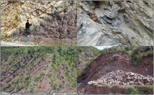
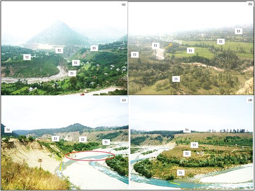
Rapid tectonic uplift in any region changes the equilibrium state and longitudinal profile of the major river systems triggering rapid incision and formation of river terraces. The river terraces are assumed to develop in response to pulses of tectonic uplift. Such tectonic pulses greatly control the development of different levels of terraces and control the morphology of fluvial systems (Valdiya, Citation1993, Citation1998, Citation2003). Repetitive and alternate pulses of vertical incision and lateral erosion produce paired river terraces on both sides of rivers. However, lateral shifting of river course due to active tectonics and uplift produce unpaired terraces. Formation of such unpaired terraces are key evidences of higher tectonic control on river course in any region. Recent tectonic activity in KB is demonstrated by the formation of numerous levels of unpaired terraces in most river sections. The different terrace levels represent multiple tectonic upheavals in the past. The absence of same age and same lithological terraces on either side of river banks suggest basin tilting due to tectonic activity causing erosion of same age terraces on one side of the river while deposition of terraces on other side. The level of terraces varies from one river system to other (). At most places in deformed and uplifted sections or blocks, the terrace material is mixed with debris flow representative of high erosion conditions. Usually most of the rivers in KB have three level of terraces but some rivers even have upto five level of terraces. These terraces are composed of river eroded material comprising sand, silt, clay, gravels and conglomerates.
Figure 13. Presence of different unpaired terraces (a) Jhelum river Uri (b) Erin at Bandipora (c) Shaliganga river Budgam and (d) Rambiara river Shopian. The absence of equivalent paired terraces suggest basin tilting and higher structural control.
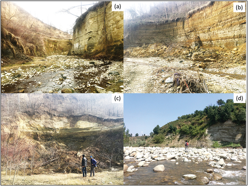
The rate of river incision provides important clues about the regional uplift of any area (Burbank et al., Citation1996; Lavé & Avouac, Citation2000). Rapid and continuous uplift in mountainous regions increase the threshold capacity of rivers and trigger a higher vertical incision (Bull, Citation1979). Although such incision rates are also climate dependent (Bull, Citation1990; Schumm et al., Citation2002). The continuous uplift of Himalayan belt as well as of KB floor has prompted an accelerated vertical incision in most rivers leading to formation of deeply incised and entrenched river valleys (). The presence very steep and >100 m deep river valleys within Quaternary sediments suggest rapid uplift of this region triggering higher vertical incision conditions. Such valleys are mostly observed along the southern portion of the basin where thick piles of Karewa sediments have been considerably uplifted acting as suitable sites for vertical incision. Such incised valleys are continuously eroded at the base causing land sliding and damping of rivers prompting frequent flood conditions in these river valleys.
Figure 14. Deeply incised valleys formed due to higher vertical erosion in planar areas. Note the occurrence of landslides along these steep cliffs due to basal erosion of river banks.
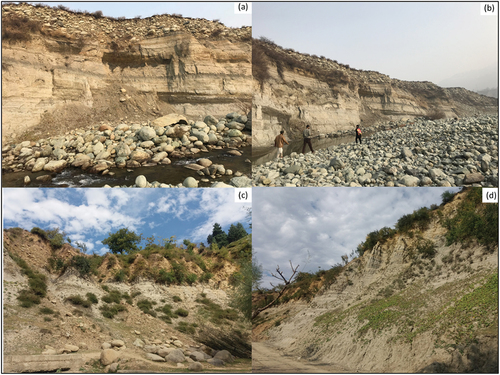
Strath terraces provide information about incision of bedrock by rivers and planation activities as well as rate of valley narrowing and widening (Bull, Citation1991). They echo landscape evolution in uplifted regions either due to climate, tectonics, rock type or other forces. When river valleys with a thin cover of alluvium shift and abandon original course due to humid climate with greater suspended sediments (Wegmann & Pazzaglia, Citation2002) or change in base level either due to sea level change of regional tectonics causing uplift (Merritts et al., Citation1994), vertical incision of bedrock increases leading to formation of planar strath surfaces of terraces. Theses terraces have a nearly horizontal contact with the underlying bedrock usually mantled by a thin (<2 m) alluvium cover (Pazzaglia, Citation2013). The higher rate of ongoing tectonism and subsequent rapid uplift has prompted the formation of strath terraces along the banks of all rivers in KB. The shifting of river courses due to Quaternary slip along intra-basinal faults as well regional crustal scale faults have greatly affected the rate of formation of these strath terraces. Most of the strath terraces are found along steep cliffs very close to the active faults. Such terraces are mostly composed of river bed material (intermixed sand, clay, gravels and boulders; ). Their lithology suggests higher pulses of uplift and rapid erosion of uplifted regions mainly the Pir Panjal ranges. (Madden et al., Citation2011, Citation2010) suggested that BF has uplifted and distorted five strath terraces in Sasara River and two in Rambiara River. Presence of such numerous Quaternary strath terraces indicate higher rate of ongoing tectonism in KB.
Figure 15. Strath terraces (a) and (b)Rambiara river Shopian (c) Doodhganga river Budgam and (d) Shaliganga river Budgam.
Conclusion
In present study, a detailed investigation of geomorphic indices, drainage patterns, structural features (faults and lineament), and tectonically induced geomorphological features was carried out to evaluate the tectonic and geomorphic evolution as well as relative tectonic activity of the Kashmir Basin. Our investigation led to following points.
The morphometric and morphotectonic analysis at sub-basin level suggests the dominant role of active tectonics in kinematics and structural evolution of KB.
The basin has developed rejuvenated terrain morphology, fault scarps, offset of Holocene sedimentary successions, active mountain fronts, offsetted drainage patterns reflecting Quaternary tectonic deformation in this region.
The drainage pattern of KB is highly elusive. Most of the river courses have been modified by ongoing tectonism resulting in formation of deflected and beheaded streams showing higher structural control by subsurface tectonic structures.
The lineament analysis shows that the southern part of the basin contain numerous and dense linear geomorphic features oriented in NW-SE to NNW-SSE direction, parallel to the regional mega deformational features. This indicates that the basin floor is responding to regional stress conditions and deforming continuously, however, rapid erosion continuously modifies the deformational structures.
Geomorphological field investigation suggest that the basin is relatively active and rapid uplift has led to formation of deeply incised valleys, strath surfaces, uplifted river terraces, warped fluvial surfaces, abandoned river channels indicating that the intrabasinal faults as well as regional structures collectively are responsible for sculpting basin geometry.
Disclosure statement
No potential conflict of interest was reported by the author(s).
References
- Agarwal, K. K., & Agrawal, G. K. (2005). A genetic model of thrust-bounded intermontane basin using scaled sandbox analogue models: An example from the Karewa Basin, Kashmir Himalayas, India. International Journal of Earth Sciences, 94(1), 47–52. https://doi.org/10.1007/s00531-004-0438-z
- Ahmad, S., Alam, A., Ahmad, B., Bhat, M. I., & Bhat, M. S. (2015). Geomorphic evidence of unrecognized Balapur fault segment in the southwest Kashmir basin of northwest Himalayas. Geomorphology, 250, 159–172. https://doi.org/10.1016/j.geomorph.2015.09.006
- Ahmad, S., Bhat, M. I., Madden, C., & Bali, B. S. (2014). Geomorphic analysis reveals active tectonic deformation on the eastern flank of the Pir Panjal Range, Kashmir Valley, India. Arabian Journal of Geosciences, 7(6), 2225–2235. https://doi.org/10.1007/s12517-013-0900-y
- Ahmad, S., & Bhat, M. I. (2012). Tectonic geomorphology of the Rambiara basin, SW Kashmir Valley reveals emergent out-of-sequence active fault system. Himalayan Geology, 33(2), 162–172.
- Ahmad, S., & Bhat, M. I. (2013). Investigating drainage response to the Balapur fault interaction on the northeastern Pir Panjal flank, Kashmir valley. Journal of Himalayan Ecology and Sustainable Development, 8, 121–137.
- Ali, U., Ali, S. A., Yousuf, M., Rasool, Q. A., Ahmad, M., & Ahmad, I. (2021). Consideration of geomorphic indices in assessment of relative active tectonics in a part of seismogenic compressional Kashmir Basin. Arabian Journal of Geosciences, 14(13), 1–15. https://doi.org/10.1007/s12517-021-07523-3
- Bali, B. S., Wani, A. A., Khan, R. A., & Ahmed, S. (2016). Morphotectonic analysis of the Madhumati watershed, Northeast Kashmir Valley. Arabian Journal of Geosciences, 9(5), 1–17. https://doi.org/10.1007/s12517-016-2395-9
- Bali, R., Agarwal, K. K., Ali, S. N., Rastogi, S. K., & Krishna, K. (2012). Drainage morphometry of Himalayan Glacio-fluvial basin, India: Hydrologic and neotectonic implication. Environmental Earth Sciences, 66(4), 1163–1174. https://doi.org/10.1007/s12665-011-1324-1
- Basavaiah, N., Appel, E., Lakshmi, B. V., Deenadayalan, K., Satyanarayana, K. V. V., Misra, S., Juyal, N., & Malik, M. A. (2010). Revised magnetostratigraphy and characteristics of the fluviolacustrine sedimentation of the Kashmir basin, India, during Pliocene‐Pleistocene. Journal of Geophysical Research: Solid Earth, 115(B8), 1–17.https://doi.org/10.1029/2009JB006858
- Bhat, M. I. (1982). Thermal and tectonic evolution of the Kashmir basin vis-a-vis petroleum prospects. Tectonophysics, 88(1–2), 117–132. https://doi.org/10.1016/0040-1951(82)90205-0
- Bhatt, D. K. (1975). On the quaternary geology of the Kashmir valley with special reference to stratigraphy and sedimentation. Geological Survey of India Miscellaneous Publication, 24(1), 188–203.
- Bilham, R. (2019). Himalayan earthquakes: A review of historical seismicity and early 21st century slip potential. Geological Society, London, Special Publications, 483(1), 423–482. https://doi.org/10.1144/SP483.16
- Bull, W. B. (1990). Stream-terrace genesis: implications for soil development. Geomorphology, 3(3–4), 351–367.
- Bull, W. B. (1991) Geomorphic responses to climatic change. osti.gov. https://www.osti.gov/biblio/5603696
- Bull, W. B. (1979). Threshold of critical power in streams. Geological Society of America Bulletin, 90(5), 453–464. h ttps://d oi.org/1 0.1130/0016-7606(1979)90<453:TOCPIS>2.0.CO;2
- Bull, W. B. (2008). Tectonic geomorphology of mountains: A new approach to paleoseismology. John Wiley & Sons.
- Burbank, D. W., & Johnson, G. D. (1983). The late Cenozoic chronologic and stratigraphic development of the Kashmir intermontane basin, northwestern Himalaya. Palaeogeography, Palaeoclimatology, Palaeoecology, 43(3–4), 205–235. https://doi.org/10.1016/0031-0182(83)90012-3
- Burbank, D. W., Leland, J., Fielding, E., Anderson, R. S., Brozovic, N., Reid, M. R., & Duncan, C. (1996). Bedrock incision, rock uplift and threshold hillslopes in the northwestern Himalayas. Nature, 379(6565), 505–510. https://doi.org/10.1038/379505a0
- Burbank, D. W., & Reynolds, R. G. (1984). Sequential late Cenozoic structural disruption of the northern Himalayan Foredeep. Nature, 311(5982), 114–118. https://doi.org/10.1038/311114a0
- Burbank, D. W. (1983). The chronology of intermontane-basin development in the northwestern Himalaya and the evolution of the Northwest Syntaxis. Earth and Planetary Science Letters, 64(1), 77–92. https://doi.org/10.1016/0012-821X(83)90054-7
- Ganju, J. L., & Khar, B. M. (1984). Tectonics and hydrocarbon prospects of Kashmir valley-possible exploration targets. Petroleum Asia Journal, 7(1), 207–217.
- Gavillot, Y., Meigs, A., Yule, D., Heermance, R., Rittenour, T., Madugo, C., & Malik, M. (2016). Shortening rate and Holocene surface rupture on the Riasi fault system in the Kashmir Himalaya: Active thrusting within the Northwest Himalayan orogenic wedge. Geological Society of America Bulletin, 128(7–8), 1070–1094. https://doi.org/10.1130/B31281.1
- Goswami, P. K., & Pant, C. C. (2007). Geomorphology and tectonics of Kota–Pawalgarh Duns, Central Kumaun Sub-Himalaya. Current Science, 92(5), 685–690. https://www.jstor.org/stable/24097861
- Hack, J. T. (1973). Stream-profile analysis and stream-gradient index. Journal of Research of the US Geological Survey, 1(4), 421–429. https://pubs.usgs.gov/journal/1973/vol1issue4/report.pdf#page=49
- Hallet, B., & Molnar, P. (2001). Distorted drainage basins as markers of crustal strain east of the Himalaya. Journal of Geophysical Research: Solid Earth, 106(B7), 13697–13709. https://doi.org/10.1029/2000JB900335
- Han, L., Liu, Z., Ning, Y., & Zhao, Z. (2018). Extraction and analysis of geological lineaments combining a DEM and remote sensing images from the northern Baoji loess area. Advances in Space Research, 62(9), 2480–2493. https://doi.org/10.1016/j.asr.2018.07.030
- Hooper, D. M., Bursik, M. I., & Webb, F. H. (2003). Application of high resolution, interferometric DEMs to geomorphic studies of fault scarps, Fish Lake Valley, Nevada-California, USA. Remote Sensing of Environment, 84(2), 255–267. https://doi.org/10.1016/S0034-4257(02)00110-4
- Jaiswal, M. K., Bhat, M. I., Bali, B. S., Ahmad, S., & Chen, Y. G. (2009). Luminescence characteristics of quartz and feldspar from tectonically uplifted terraces in Kashmir Basin, Jammu and Kashmir, India. Radiation Measurements, 44(5–6), 523–528. https://doi.org/10.1016/j.radmeas.2009.04.008
- Kaya, Ş., Müftüog˘ Lu, O., & Tüysüz, O. (2004). Tracing the geometry of an active fault using remote sensing and digital elevation model: Ganos segment, North Anatolian Fault zone, Turkey. International Journal of Remote Sensing, 25(19), 3843–3855. https://doi.org/10.1080/01431160310001652394
- Keller, E. A., & Pinter, N. (2002). Earthquakes, uplift, and landscape. Prentice Hall.
- Kuhle, M. (2005). Glacial geomorphology and ice ages in Tibet and the surrounding mountains. Island Arc, 14(4), 346–367. https://doi.org/10.1111/j.1440-1738.2005.00501.x
- Lavé, J., & Avouac, J. P. (2000). Active folding of fluvial terraces across the Siwaliks Hills, Himalayas of central Nepal. Journal of Geophysical Research: Solid Earth, 105(B3), 5735–5770. https://doi.org/10.1029/1999JB900292
- Madden, C., Ahmad, S., & Meigs, A. (2011, December) Geomorphic and paleoseismic evidence for late Quaternary deformation in the southwest Kashmir Valley, India: Out-of-sequence thrusting, or deformation above a structural ramp? In AGU Fall Meeting abstracts (American Geophysical Union).
- Madden, C., Trench, D., Meigs, A., Ahmad, S., Bhat, M. I., & Yule, J. D. (2010). Late quaternary shortening and earthquake chronology of an active fault in the Kashmir Basin, Northwest Himalaya. Seismological Research Letters, 81(2), 346. https://doi.org/10.1785/gssrl.81.2.284
- Malik, J. N., & Mohanty, C. (2007). Active tectonic influence on the evolution of drainage and landscape: Geomorphic signatures from frontal and hinterland areas along the Northwestern Himalaya, India. Journal of Asian Earth Sciences, 29(5–6), 604–618. https://doi.org/10.1016/j.jseaes.2006.03.010
- Marple, R. T., & Talwani, P. (1993). Evidence of possible tectonic upwarping along the South Carolina coastal plain from an examination of river morphology and elevation data. Geology, 21(7), 651–654. h ttps://d oi.org/1 0.1130/0091-7613(1993)021<0651:EOPTUA>2.3.CO;2
- McCalpin, J. P. (2009). Application of paleoseismic data to seismic hazard assessment and neotectonic research. International Geophysics, 95, 1–106. https://doi.org/10.1016/S0074-6142(09)95009-4
- Menier, D., Mathew, M., Pubellier, M., Sapin, F., Delcaillau, B., Siddiqui, N., Ramkumar, M., & Santosh, M. (2017). Landscape response to progressive tectonic and climatic forcing in NW Borneo: Implications for geological and geomorphic controls on flood hazard. Scientific Reports, 7(1), 1–18. https://doi.org/10.1038/s41598-017-00620-y
- Merritts, D. J., Vincen, K. R., & Wohl, E. E. (1994). Long river profiles, tectonism, and eustasy: A guide to interpreting fluvial terraces. Journal of Geophysical Research: Solid Earth, 99(B7), 14031–14050. https://doi.org/10.1029/94JB00857
- Nakata, T. (1972). Geomorphic history and crustal movement of the foot-hills of the Himalayas. Science Report Tohoku Univ 7th series (Geography), Tohoku University,22, 39–177.
- Nakata, T. (1989). Active faults of the Himalaya of India and Nepal. In Tectonics of the Western Himalayas. 232, 243–264. https://books.google.co.in/books?hl=en&lr=&id=_GJ_ekVuJRgC&oi=fnd&pg=PA243&dq=Nakata,+T.+(1989).+Active+faults+of+the+Himalaya+of+India+and+Nepal.+In+Tectonics+of+the+Western+Himalayas.+232,+243%E2%80%93264.&ots=_aPvdpp6z9&sig=qpVW_AtNUAwdUbdU2C_0bjqY2Sc&redir_esc=y#v=onepage&q&f=false
- Novak, I. D., & Soulakellis, N. (2000). Identifying geomorphic features using LANDSAT-5/TM data processing techniques on Lesvos, Greece. Geomorphology, 34(1–2), 101–109. https://doi.org/10.1016/S0169-555X(00)00003-9
- Pazzaglia, F. J. (2013). 922 Fluvial Terraces. Treatise on Geomorphology, 379–412. https://doi.org/10.1016/B978-0-12-374739-6.00248-7 https://www.sciencedirect.com/topics/earth-and-planetary-sciences/river-terrace
- Philip, G., Sah, M. P., & Virdi, N. S. (2006). Morpho-structural signatures of active tectonics in parts of Kangra valley, NW Himalaya, India. Himalayan Geology, 27(1), 15–30.
- Pike, R. J., & Wilson, S. E. (1971). Elevation-relief ratio, hypsometric integral, and geomorphic area-altitude analysis. Geological Society of America Bulletin, 82(4), 1079–1084. h ttps://d oi.org/1 0.1130/0016-7606(1971)82[1079:ERHIAG]2.0.CO;2
- Salehi, R., Saadi, N. M., Khalil, A., & Watanabe, K. (2015). Integrating remote sensing and magnetic data for structural geology investigation in pegmatite areas in eastern Afghanistan. Journal of Applied Remote Sensing, 9(1), 096097. https://doi.org/10.1117/1.JRS.9.096097
- Schumm, S. A., Schumm, S. A., Dumont, J. F., & Holbrook, J. M. (2002). Active tectonics and alluvial rivers. Cambridge University Press.
- Seeber, L., & Gornitz, V. M. (1983). River profiles along the Himalayan arc as indicators of active tectonics. Tectonophysics, 92(4), 335–367. https://doi.org/10.1016/0040-1951(83)90201-9
- Shah, A. A. (2013). Earthquake geology of Kashmir Basin and its implications for future large earthquakes. International Journal of Earth Sciences, 102(7), 1957–1966. https://doi.org/10.1007/s00531-013-0874-8
- Shah, A. A. (2015). Kashmir basin fault and its tectonic significance in NW Himalaya, Jammu and Kashmir, India. International Journal of Earth Sciences, 104(7), 1901–1906. https://doi.org/10.1007/s00531-015-1183-1
- Srivastava, V., Mukul, M., & Mukul, M. (2017). Quaternary deformation in the Gorubathan recess: Insights on the structural and landscape evolution in the frontal Darjiling Himalaya. Quaternary International, 462(Special Issue), 138–161. https://doi.org/10.1016/j.quaint.2017.05.004
- Starke, J., Ehlers, T. A., & Schaller, M. (2017). Tectonic and climatic controls on the spatial distribution of denudation rates in Northern Chile (18 S to 23 S) determined from cosmogenic nuclides. Journal of Geophysical Research: Earth Surface, 122(10), 1949–1971. https://doi.org/10.1002/2016JF004153
- Strahler, A. N. (1952). Hypsometric (area-altitude) analysis of erosional topography. Geological Society of America Bulletin, 63(11), 1117–1142. h ttps://d oi.org/1 0.1130/0016-7606(1952)63[1117:HAAOET]2.0.CO;2
- Strahler, A. N. (1969). Physical Geography. John Willey and Sons. Inc.
- Thakur, V. C., & Rawat, B. S. (1992). Geologic map of Western Himalaya: Dehra Dun India. Wadia Institute of Himalayan Geology, Scale, 1(1,000,000).
- Valdiya, K. S. (1993). Uplift and geomorphic rejuvenation of the Himalaya in the Quaternary period. Current Science, 64(11/12), 873–885. https://www.jstor.org/stable/24096201
- Valdiya, K. S. (1998). Dynamic Himalaya. Universities press.
- Valdiya, K. S. (2003). Reactivation of Himalayan frontal fault: Implications. Current Science, 85(7), 1031–1040. https://www.jstor.org/stable/24108786
- Wang, J., & Howarth, P. J. (1990). Use of the Hough Transform in automated lineament. IEEE Transactions on Geoscience and Remote Sensing, 28(4), 561–567. https://doi.org/10.1109/TGRS.1990.572949
- Wegmann, K. W., & Pazzaglia, F. J. (2002). Holocene strath terraces, climate change, and active tectonics: The Clearwater River basin, Olympic Peninsula, Washington State. Geological Society of America Bulletin, 114(6), 731–744. h ttps://d oi.org/1 0.1130/0016-7606(2002)114<0731:HSTCCA>2.0.CO;2
- Yin, A. (2006). Cenozoic tectonic evolution of the Himalayan orogen as constrained by along-strike variation of structural geometry, exhumation history, and foreland sedimentation. Earth-Science Reviews, 76(1–2), 1–131. https://doi.org/10.1016/j.earscirev.2005.05.004
- Yousuf, M., & Bukhari, K. S. (2019). Impact of geological and environmental complexities over infrastructure development in Kashmir Himalaya. Disaster Advances, 12(4), 29–40.
- Yousuf, M., & Bukhari, K. (2020). Hazard estimation of Kashmir Basin, NW Himalaya using probabilistic seismic hazard assessment. Acta Geophysica, 68 (5), 1295–1316. https://doi.org/10.1007/s11600-020-00485-2 (b).
- Yousuf, M., Bukhari, S. K., Bhat, G. R., & Ali, A. (2020). Understanding and managing earthquake hazard visa viz disaster mitigation strategies in Kashmir valley, NW Himalaya. Progress in Disaster Science, 5, 100064. https://doi.org/10.1016/j.pdisas.2020.100064
- Yousuf, M., & Bukhari, S. K. (2020). Evaluation of seismically induced Soft Sediment deformation structures vis-a-vis their probable earthquake sources in Kashmir basin, NW Himalaya. Journal of Earthquake and Tsunami, 15 (1), 2150003. https://doi.org/10.1142/S1793431121500032 (a).