
ABSTRACT
Since 1970, the Masan Bay and its vicinity have long been the center of national economic growth for Korea. However, the bay and its estuary got drastically polluted due to rapid industrialization and urbanization. The Bongam tidal flat, as a brackish estuary of Masan Bay, is located in the center of Changwon city, and situated near the Changwon industrial complex zone. The Community Advisory Council (CAC) for Masan Bay established since 2005 as a legal organization of local governance for ecosystem recovery. The loading of COD to the tidal flat of Bay mouth through streams gradually was reduced from 2,090 kg/d in 2006 to 432 kg/d in 2016 by the holistic efforts of local governance. The experience of local governance shows the procedure of how they recovered an urban tidal flat, as well as Masan Bay, and how stakeholders participated and worked together. The lessons learned include the relevance and impacts of coordination mechanisms in conflict resolution even though there was rivalry, competition, and different constituency expectations among stakeholders. In this case study, we also illustrate how the CAC could facilitate stronger cooperation and coordination with relevant agencies at the national and local levels.
Introduction
A variety of coastal activities between 1970 and 1980 had caused damages to the fishing, aquaculture and tourism industries in the Masan Bay, Changwon, South Korea. A significant amount of sewage was discharged through streams and tributaries into the Bay without proper treatment leading to the closure of recreational beaches and prohibition of shellfish harvesting in 1979. Park (Citation1987) reported the first large-scale red tide outbreak at Masan Bay in 1981. Masan Bay is a typically enclosed bay surrounded by land and islands. The reclamation of Masan Bay has induced sharp declines in its natural coastlines and decrease in depth due to sedimentation. The Masan Bay was designated as one of the Special Management Area (SMA). A large sewage treatment plant was constructed; started operation in 1994 and further upgraded in 2007. Sediment dredging to the bay bottom was undertaken as a decontamination process from 1990 to 1994. The amended Marine Pollution Prevention Act in 1999 provides legal framework for the watershed-based approach for marine environmental management in Korea. In this study, we focused on the critical lessons learned from the local governance initiatives describing the following:
It is possible to restore coastal ecosystem even located in urban centers and center of industrial activities
The need to take a holistic bay-wide approach (Masan Bay) including the implementation of Total Pollutant Load Management (TPLM), thus in line the ICM approach
The effectiveness of the coordinating functions of the Community Advisory Council (CAC)
Chronological incoming loading data from 2005 to 2016, as well as sediment data from 2006 to 2012 relating to local governance explained the environmental changes of Bongam tidal flat.
Location, materials, and methods
Location of Masan Bay
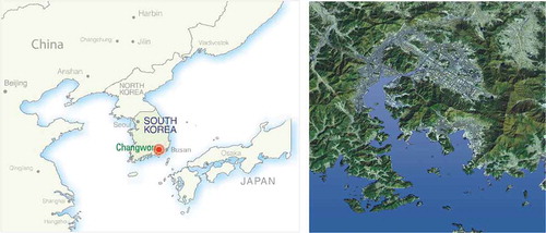
Masan Bay is located on the southeast coast of the Korean peninsula, acting as a gateway to other countries like Japan, Russia, and China (). The location provides the city with abundant opportunities to be a center of trade as a port city. Masan has become famous for its trade capacity among other towns in Korea due to its strategic location as a collecting center of agricultural and fisheries products.
Figure 1. Location map of Masan Bay.
Sampling of stream water and sediment
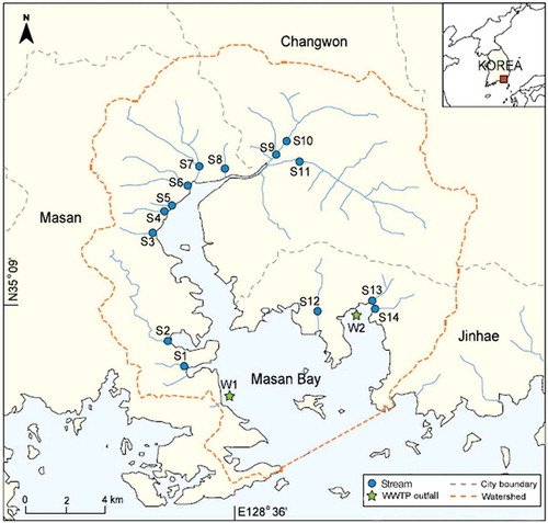
Based on the Total Pollutant Load Management System (TPLMS), water quality at 14 streams (S1 to S14 in ) and two wastewater treatment plants (WWTP; W1 and W2) are monitored every month. In the summer season, 14 streams are monitored every 10 days. At each site, we obtained water samples from the lowest position of each stream using a bucket sampler. Various water quality variables measured with key parameters of COD, suspended sediment (SS), total nitrogen (TN), and total phosphorus (TP). We collected water quality data of their influent and effluent from the local WWTP management agency to trace and monitor effluent water quality of two WWTPs (inland point sources). The two target WWTPs are located in the southern part of Masan Bay, one serving Masan and Changwon (W1) and the other one Jinhae (W2). Daily load for COD, biological oxygen demand (BOD), SS, TN, TP, and flow rate during the same period as stream sampling (i.e., June 2005 to December 2016) were collectively used to calculate land-based pollution loads. In this study, we analyzed and showed the data from three streams (S9, S10, and S11) affecting the ecosystem of Bongam tidal flat in the results.
Figure 2. Map showing the sampling locations in Masan Bay area.
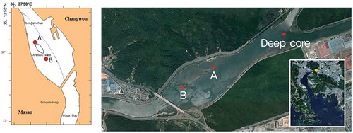
The sediment sampling area is the estuary waterway (), which is an essential pathway from the city area to Masan Bay. Companies in the Changwon Machinery Industrial Complex dealing with heavy metals are also located in the watershed of Bongam tidal flat. The Korea Engineering Consultant Corp obtained a single sediment core sample and donated it to our laboratory for research purposes. Sub-sediment samples were obtained from various depths of the boring, ranging from 0 to 17 m in depth. These deep core samples represent background samples for the estuaries of Masan Bay. shows the location of the deep core site. Sediment samples were collected from site A and B by grab sampling from August 2006 to August 2012.
Figure 3. Locations of deep core and sediments sampling site in the Bongam tidal flat.
Stream water and heavy metal analysis
All the water samples from the watershed streams were immediately transferred to the laboratory, and water parameters analyzed according to the Korean water quality test guideline (MOE Citation2008). For analysis of the metals, we dried the sediment increments at 105°Cfor five hours and passed through a 32-mesh nylon sieve. One gram of sample was digested with a mixture of 5 mL of sulfuric acid and 5 mL of nitric acid in a Kjeldahl flask (200 mL volume).
The resultant solutions were diluted to 100 mL with deionized-distilled water. The concentrations of Fe, Mn, and Zn were measured by a flame atomic absorption spectrophotometer (Model Shimazu AA-670). For the determination of Cu, Pb, and Cd, extraction with methyl isobutyl ketone (MIBK) was performed after sodium-diethyl dithiocarbamate (DDTC) treatment, and final measurement by flame atomic absorption spectrophotometry (Honda et al. Citation1982). Corrections for the background interference were made by running appropriate blanks. The accuracy of this method was determined in the laboratory by spiking the standard materials with known amounts of Fe, Mn, Zn, Cu, Pb, and Cd with recoveries of 90.0–99.9% according to APHA (Citation1992), methods 302 and 303.
Results and discussion
Historical and social context of local governance in Masan Bay and Bongam tidal flat
Masan Bay in Changwon, Gyeongnam province, has been a historical harbor from which high quality iron was transported to neighboring countries 2000 years ago. Cultural remains throughout the history show us that Changwon has been abundantly blessed with a natural environment, especially in the marine resources. A new structured harbor in Masan Bay was opened in 1899. The Bongam tidal flat, the only tidal flat in the nation located within a trade port bay, is a coastal wetland along the brackish water zone where the fresh water and sea water merge from the point where Changwon stream and Nam stream meet to the area of Bongam Bridge in Masan Bay. In other words, the urban (Bongam) tidal flat is located at an inlet of Masan Bay and in the front of several factories at the entrance of Changwon Machinery National Complex.
The Masan Bay, in which our regional growth took place since the beginning of 1970, was drastically polluted due to the industrialization and population growth. In 1979, the Fisheries Agency announced the prohibition of collecting fish and shellfish in Masan Bay.
The government set out large-scale reclamation projects around Masan Bay area in the 1960s to secure lands for industrial complexes. At that time, there were no environmental impact assessment policies or regulations. Thus, these developments and reclamation were conducted without considering the environmental capacity of the Bay, which negatively affects the water quality significantly. Accordingly, the sea area in the Masan Bay reduced from 19.5 km2 in 1964 to 14.3 km2 in 2011.
Masan Bay was designated as a SMA in 1982. The SMA of Masan Bay has enabled concerned government agencies to implement projects, mitigate pollution, rehabilitate already polluted areas, and to take preventive and remedial actions. The amended Marine Pollution Prevention Act in 1999 provides legal framework for the watershed-based approach to be applied to marine environmental management in Korea.
Bongam tidal flat could no longer support life. A businessman announced that he would reclaim the Bongam tidal flat and build a RMC (ready-mixed concrete) factory in 1999 because it was neglected since it was a small piece of tidal flat considered to be useless under reclamation pressure. However, it was protected when an NGO rejected the reclamation and GO accepted the suggestion from NGO. An NGO alliance for Masan Bay restoration was launched in 2000 to begin governance activities for cooperation with the government. This was a starting point of local governance with the community’s participation. Despite the efforts, however, a significant gap in the ecosystem recovery still existed. Recognizing that the coastal zone of Masan Bay is a complex system, integrated coastal management (ICM) can move beyond traditional approaches to employ a holistic perspective system that understands the interconnections between the coastal system and coastal utilization. The Korean government had been planning to introduce a TPLM system into the coastal environment management regime of the Masan Bay as the first model case in Korea as a modified ICM. The CAC for Masan Bay was started in 2005 as a legal organization for Masan Bay’s ecosystem recovery by the systematic approach of Korea Maritime Institute (KMI) assistance. Based on the newly formulated mechanisms, central government, local government, three Cities, Navy, Academies, business sectors, and NGOs established a CAC at that time. Restoration efforts were given to the Bongam tidal flat since then.
This tidal flat was assigned as an official visit site during the COP10 Ramsar Convention in 2008 to raise the public awareness of the importance of the ecosystem. The CAC for Masan Bay established an eco-tour program that provides citizens with an opportunity to witness the restoration of the ecosystem and the mudflat ecosystem service.
Eco-education Center of the Bongam tidal flat was created in 2001. It is a highly valued tidal flat being used as an in-situ education site with the cooperation of governance to educate the local community on the importance of the environment and to preserve the ecological condition of Masan Bay and Bongam tidal flat as well.
The pollutant load originating in Changwon’s watershed is either delivered to the WWTP through sewer line or enters the Masan bay after passing through the Bongam tidal flat. The Bongam tidal flat is 10,285m2 in size which is comparably small. However, it acts as a natural purifier for pollutants entering the Masan Bay and forms a natural ecological system that can be hardly seen nearby the industrial complex. Moreover, this is a home to all kinds of salt marshes and about 50 types of migratory birds, crabs, and mud worms.
Changwon, Masan, and Jinhae, are three cities which shared the same sphere of living, and were merged into “Changwon,” the first integrated city in Korea with a population of 1.08 million people in 2010. Changwon is now taking on the appearance as an international city leading in a changing lifestyle in this climate change era. Changwon has been making efforts to form an eco-transportation system as an action for low carbon emissions under its long-term program of becoming the world’s environmental capital in 2020.
Ecosystem recovery of Masan and Bongam urban tidal flat
In most countries with a marine coast, development-oriented national policies have historically led to the concentration of populations and industrial activities in areas adjacent coastal zones. For many developing countries, shipping, fishing, aquaculture, and coastal tourism are vitally essential to their economies. Notwithstanding this importance, coastal resources are often developed with a land-oriented perspective that fails to consider the unique physical and ecological characteristics of the coast. The Masan Free Trade complex was set up in 1970, and the Changwon Machinery National Complex was developed in 1974.
During the last 44 years, urban, industrial, and port developments have dramatically modified the natural features of the bay, with its tidal wetlands reclaimed to accommodate the expansion of a large population and an ever-growing industry. Thus, the problems of pollution have steadily increased and become a matter of public concern. The water quality of Masan Bay has quickly deteriorated because Masan Bay is an enclosed bay and has a narrow opening to the sea. The chemical oxygen demand (COD) load of 38,185 kg/day estimated to be because of discharges from Masan city and Changwon city in 1988 (Lee and Min Citation1990).
As a result, wastes, including untreated municipal sewage and industrial wastewater, which led to harmful algal blooms (HAB), sharp oxygen depletion, loss of aquatic life, and aesthetic problems quickly and heavily polluted the bay. Additionally, due to significant bacteriological pollution, Gapo Beach finally closed in 1975. Masan Bay has identified as a coastal area that is becoming one of the most polluted estuaries in Korea.
According to the National Water Quality Assessment, the mean value of COD from 1997 to 2006 in Masan Bay was 2.4 mg/L, which was two times more than the national average (1.15 mg/L). This quality was a Level III, not suitable for fisheries or recreational activities but suitable for industrial use. In 1994, COD level reached to 5.8 mg/L, and HAB event occurred in Masan Bay covering 15% of the national occurrence, demonstrating the frequent occurrence of red tide. The physical parameters of Masan Bay result in pollutants being flushed slowly and eventually accumulated. The maximum flood and ebb currents during spring tide (on 15–30 July 1988) were observed at 13–27 cm/s and 11–21 cm/s, respectively. The maximum flood and ebb currents during neap tide in the same period were 6–9 cm/s and 5–8 cm/s (Lee and Min Citation1990). The water depth at Masan Bay ranges between 5 m (in the inner bay) and 25 m (in the central part). The continuous influx of sewage and other wastes rich in nutrients like nitrogen and phosphorous to the coastal waters of Masan Bay have induced a severe and frequent red-tide problem, which resulted in a significant damage of shellfish and fish. Nitrogen and phosphorus rapidly increased in 1985 and maintained 1.0 mg/L as TN and 0.03 mg/L as PO4 – P, respectively.
Kim et al. (Citation2012) investigated the annual variation of seawater quality in nutrients, COD, and dissolved oxygen (DO) at three stations in Masan Bay from 1995 to 2005. The dissolved inorganic nitrogen (DIN) concentration decreased significantly at all stations after 2001, whereas the dissolved inorganic phosphorus (DIP) concentration showed no distinct annual variation. The DIN/DIP molar ratio also decreased tremendously at all stations after 2001. Chang et al. (Citation2012) reported the water quality recovery at Masan Bay that both the bay COD and SS significantly decreased from 2005 to 2010, with a noticeably dramatic decrease in 2007, immediately following the implementation of the TPLMS. Regression analysis showed a significant decreasing trend for both the surface and bottom water layers (p < 0.001); however, the bottom waters showed less variation, indicating a relative lack of flushing in the semi-closed bay system.
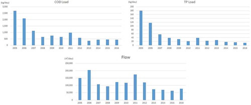
When comparing loads of COD and Total Phosphate (TP) coming into Boangam tidal flat between 2005 and 2016, we can find that the amount of loads has decreased throughout the monitoring period as shown in . The improvement of sewer lines, expansion of POTW, eco-stream projects, and the continuous attempts by the local governance decreased the pollutant loads. Finally, on 15 December 2011, MLTM designated “Masan Bay’s Bongam tidal flat” in Changwon as a Wetlands Protection Area. It has become the 11th National Coastal Wetlands Protection Area joining the Muan tidal flat, Sooncheon tidal flat, and others.
Figure 4. Temporal variation of COD, TP load and flow rate coming through Bongam tidal flat, showing: (a) Annual mean COD loads (kg/d) from the inland streams. (b) Annual mean TP loads (kg/d). (c) Flow rate (m3/d) coming through three streams from Changwon watershed to Masan Bay over the 12-year period (2005–2016).
Thus, Bongam Tidal Flat in Masan Bay is a rare tidal flat located close to the city downtown. It is a representative example of ecosystem restored by the cooperation of citizens after being confirmed 37 species of macrozoobenthos, government-designated endangered species red feet crabs, natural monument kestrel and four endangered species (level 2) including osprey, buteo, long-billed plover, and larus saundersi inhabited the area.
One problem confronted in determining sediment contamination is that sediments with different particle sizes will have different heavy metal adsorption potentials. The relative atomic variation (RAV) method (Allan and Brunskill Citation1976), which can be used to reduce the grain size effects on heavy metal accumulations in sediments by correlating element pairs. The initial step in determining RAV is to construct a plot of “element A” concentration (x-axis) versus “element B” concentration (y-axis) from several sampled depths of a single sediment core. The RAV is a numerical value of the slope of the best-fitting straight line through the plotted points by the linear regression technique. Thus, we can regard the RAV as the “average ratio” of one element to another. By this correlation procedure, geochemical imbalances in sediments can be detected. The similarity in the RAV implies a similarity or eventual homogeneity in a large number of processes in the geochemical cycle, including weathering, transport, deposition, and biological perturbation. By using the RAV and background level, Lee et al. (Citation1990) revealed that zinc, copper, cadmium, lead, and chromium were the main contaminated metals in the sediments from Masan Bay and its estuary.
Heavy metal concentrations of sediments, including Bongam deep core, are listed in and . All the metals investigated show considerable variation from sediment to sediment, and in many cases, even within a single core. A higher concentration of zinc, copper, lead, and chromium was detected in the upper layer.
Table 1. Heavy metal content in the deep core of Bongam estuary (Unit: ppm on dry weight).
Table 2. Contamination evaluation of Bongam tidal flat sediments by Korea SQG for clean-up.
The zinc (Zn), copper (Cu), cadmium (Cd), lead (Pb), and chromium (Cr) concentrations of sediments from the Bongam estuary of Masan Bay in 1988 ranged from 84 to 540, 22 to 85, 0.18 to 3.64, 24 to 108, and 15 to 70 ppm, respectively (Lee et al. Citation1990). The upper layer of the deep core was eliminated as a background since it had been disturbed or mixed up with other soils during the construction of a bank. The Bongam deep core and its various average metal concentrations were representatives of a natural background because of the consistency of metal concentrations with great depth indicating natural weathering and deposition. The background zinc concentration was established to be 170.4 ppm, while the lead background was 28.4. The background concentrations of manganese, copper, cadmium, and chromium were 393.6, 28.6, 1.3, and 28.1 ppm, respectively.
We found some differences and similarities of sediments in the average values of metal concentration in . For lead of sediments from Bongam tidal flat, the results show that contamination level moved from “heavily polluted” in 2006 and 2009 to “not polluted” in 2010~2012. There was no polluted sediment found after 2010 except copper. For copper, there was still “intermediate polluted” showing the values between level 1 and level 2, but the trend decreased annually. The content of heavy metals in site A was higher than that of site B especially when sediments were contaminated in 2006 and 2009.
Governance progress for the participation of stakeholders in the coordinating mechanism
Since the 1980s, there have been public and regulatory concerns about pollution issues. For example, the central government works intensively towards reducing land-based pollution. A large sewage treatment plant started operations in November 1993 with 280,000 m3/d of treatment capacity, extended up to 500,000 m3/d, and upgraded an advanced wastewater treatment process (A2O process with filtration and UV disinfection) until 2007. Sediment dredging applied to the bay as a decontamination process from 1990 to 1994.
A TPLM system launched for Masan Bay in 2007, targeting a level of water quality that is suitable for “swimming and fishing” by 2020 (MLTM*, 2008).
The TPLMS project comprises of a total of 800 km of combined sewer networks that convey sewage to two central WWTPs that have been upgraded with an advanced biological treatment facility.
The main purpose of the TPLMS divided into two stages as follows:
The reduction of organic matter (targeting COD loads) from point sources in the watershed during 2007–2011.
The reduction of nutrients like nitrogen and phosphorus in the bay through regulating diffuse sources across the watershed during 2012–2016 and 2017–2021.
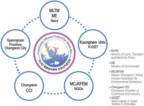
A NGO alliance for Masan Bay restoration launched in 2000 to start governance activity for the cooperation with GO. However, there should be political support and funds available to implement and enforce it in an integrated manner. In 2005, through consultation with private sectors in the Bay area, the stakeholders of the Bay came to an agreement to formulate the Comprehensive Management Plan for the Masan Bay, which includes the introduction of the TPLMS. The Plan envisioned restoring the water quality of Masan Bay to Level Ⅱ (COD range of 1–2 mg/L) through the implementation of our rigorous and science-based management tool, the TPLMS as one of ICM. During preparations for the TPLMS, the CAC for Masan Bay was established in 2005. At that time, the council composed of the stakeholders including the central government, local government, three Cities, Navy, Academies, Business sectors, and NGOs. shows the structure of the CAC because of the merging of three cities to one integrated city “Changwon.”
Figure 5. Organizational chart of CAC for Masan Bay.
*MLTM: Ministry of Land, Transport, and Maritime Affairs.
The drainage area of TPLM designated, as a SMA, is 737 km2. TPLM has been initiated since 2005 to monitor total pollution loads into Masan Bay and Bay carrying capacity, and allocated reduction load to each city (Masan City, Jinhae City, and Changwon City).
The CAC for Masan Bay had 34 regular meetings from 2006 to 2017 and 31 TFT (Task Force Team) meetings answering various issues, such as the aimed water quality, allocation of load reduction, coastal area reclamation, communication and education, public participation, the involvement of citizen science monitoring, and so on. Primary activities of the local governance include the regulation of polluted runoff by formulation of natural streams and the repair of sewer lines, bay clean up activity, TV broadcasting, and drawing contests.
NGO (MCJKFEM) has carried out the citizen science monitoring with the support from Masan Harbor Branch of MLTM, which is an excellent case of governance mechanism. The sediments and bio-species have also been monitored since 1988 up to now by local governance.
Many of the measures implemented serve as successful demonstration projects that we can extend throughout the City’s organization to benefit the ecosystem on a wider scale.
As one of the core activities, the Council sets out public awareness program, which include TPLMS education program, citizen’s monitoring, publications, international collaboration with PEMSEA, NOAA, and NGO support among others. These activities proved to be successful in the provision of information relating to environmental restoration and implementing the TPLM.
In 2012, Changwon successfully hosted the “EAS Congress” which created and excellent scene of the maritime harmony of East Asian countries. CAC for Masan Bay seeks integrated networking of social values, as well as international cooperation through PNLG and EAS Congress to build up the capacity for making necessary changes to sustainability.
Typical activities of local governance for ecosystem recovery are as follows;
Public Campaign
Through the implementation of the TPLMS, the Council envisions to make Masan Bay suitable for swimming and fishing by 2020. The Council urged its citizens to participate in the voluntary reduction of pollutants, for example, recycling of waste cooking oil and reduction of wastewater from washing machines to achieve this goal. Campaign materials were produced and broadcasted on public TV.
(b) Eco-tour program
As an effort to protect and restore the environment of the Bay, the government made the Bongam mudflat a protected area. The Council established an eco-tour program, which provides citizens with an opportunity to witness the restoration of the ecosystem and the services that the ecosystem offers, to raise the public awareness of the importance of the ecosystem.
(c) Drawing and UCC contests
The Council organizes drawings and User Created Contents contests whose theme is “Happy Bay: living Sea and Mudflat” to enlighten the young generations on the importance of the environment. The activity significantly increased the awareness of the environment among the youth.
(d) International Cooperation
The first Twinning Workshop as a PEMSEA initiative was held in Masan in June 2005 where experts and officials at various Twinning sites gathered to discuss the development of the system and share the experiences of their respective Twinning sites. The Council is actively involved in subsequent PNLG activities.
(e) Washing Machine relocation campaign for reducing pollution loads in streams
(f) Fishing waste collection campaign
(g) Coastal clean-up activities
(h) Public Participation and Education Program
(i) Governance Workshop for governmental officials
(j) Activities of International Coastal Clean-up Day
The citizens around the Masan Bay were concerned about their coastal environment and wished to return the Bay to the state it was once famous for, that is, its beautiful scenery. The coastal pollution at Masan Bay has been well controlled in a TPLM for the first time in Korea, leading to the recovery of fish and shellfish and a variety of species of birds are coming back.
This kind of restored area as a place where citizens enjoy fishing and recreation should be extended along the coast of Masan Bay. There are some problems in protecting and managing the habitat. However, there are some hopeful signs. Many students and citizens visit the Protected Wetland Area of Bongam tidal flat, contributing to the public awareness program. As a local coordinating and facilitating framework, the Community Advisory Committee played a significant role in agreeing on the water quality targets and facilitating conflicts in the load allocation process. There are many stakeholders’ participation activities, such as citizen science monitoring, the Masan Bay boat tour, public awareness and education program, marine litter cleanup and classification, joint operations with local agenda 21 and business sector, and other international cooperation.
The primary roles of the Council are to approve reduction scheme and targets, build local capacity within the system and plan implementation, and increase public awareness on TPLMS. It was proven that public awareness is the core success factor for the ecosystem recovery, because citizens’ understanding, support, and voluntary compliance are crucial. Hence, the Council sets out its comprehensive outreach program to promote the value and consequences of restoring the bay ecosystem. The Council sets a vision to transform the Masan Bay into a clean city with scenic beauty (a so-called “Coastopia”) and do away with the polluted waters. With the efforts of its citizens, the Council is hoping Masan Bay will become an exemplary case for restoring its environment glory as a beautiful Bay with clean seawater. It is clear that a close collaboration of stakeholders to achieve this objective is recovering and preserving the bay ecosystem. The governance of CAC and Local Agenda 21 has been calling for actions for a better city life and response to climate change. It is expected that the recognition of governance during CAC meetings and activities might be increased among stakeholders for more active participation.
Conclusion and recommendation
The contamination level of sediments in the tidal flat changed from high pollution to a low pollution level as evident from data collected between 2006 and 2012. The COD load coming to the tidal flat of Bay mouth through three streams gradually reduced from 2,090 kg/d in 2006 to 432 kg/d in 2016. The ecological restoration was also observed in the urban tidal flat as a habitat of otter, birds, fishes, shellfishes, and benthic organisms with the recovery of tidal flat sediments. Members of CAC found out that encouraging the participation and collaboration was a platform for building capacity, resolving conflicts among them and implementing TPLM in Masan Bay. It is relevant that there should be institutional mechanism applicable on a local base in making decisions, such as water quality targets and reclamation in the coastal seas. Good governance is characterized with openness, participation, accountability, predictability, and transparency giving stakeholders the capacity to participate in the decisions that affect their lives. There are still conflicts that need to be resolved in Masan Bay under reclamation pressure even though we learned that stakeholders’ voluntary participation is a primary success factor in achieving an ecosystem recovery. The main impacts of governance on the ecosystem recovery occur through stakeholders’ collaboration and maturity. The experience in Changwon shows the procedure on how an urban tidal flat, as well as Masan Bay, was restored and how the stakeholders have participated and worked together. Governance for the long will help reduce costs of ecosystem recovery in the long-run. Importantly, the governance requires to stay positive and to have a sense of humor and patience. It will be a long and sometimes frustrating process.
There are some recommendations as follows:
Community involvement is essential in raising awareness, training and educating the public and government officials, facilitating local government work, and encouraging responsibility and stewardship for coastal resources.
The opportunity for communications between Go and NGO to hear more voices should be provided and guaranteed at the planning stage of the local development.
Decision making within the local government should give priority to well-functioning habitats. More concerns and actions from the city are still required to preserve urban tidal flats, to create eco-friendly waterfront spaces, and to keep the coastal line intact.
Acknowledgments
This study has been supported by the Ministry of Oceans and Fisheries within the framework of TPLM Project. This work was also supported by Kyungnam University with providing CAC office and facilities.
Disclosure statement
No potential conflict of interest was reported by the authors.
References
- Allan, R. J., and G. J. Brunskill. 1976. Interactions between Sediments and Freshwater. The Hague: Junk.
- APHA (American Public Health Association). 1992. Standard Methods for the Examination of Water and Wastewater. 15th ed. New York: Water Pollution Control Federation.
- Chang, W. K., J. Ryu, Y. Yi, W. C. Lee, C. W. Lee, D. Kang, C. H. Lee, S. Hong, J. Nam, and J. S. Khim. 2012. “Improved Water Quality in Response to Pollution Control Measures at Masan Bay, Korea.” Marine Pollution Bulletin 64 (2): 427–435. doi:10.1016/j.marpolbul.2011.11.011.
- Honda, K., R. Tatsukawa, K. Itano, and T. Fujiyama. 1982. “Distribution Characteristics of Heavy Metals in the Organ and Tissues of Stripped Dolphin.” Agricultural and Biological Chemistry 46: 3011–3021.
- Kim, D., C.-W. Lee, S.-H. Choi, and Y. O. Kim. 2012. “Long-Term Changes in Water Quality of Masan Bay, Korea.” Journal of Coastal Research 28 (4): 923–929. doi:10.2112/JCOASTRES-D-11-00165.1.
- Lee, C. W., and B. Y. Min. 1990. “Pollution in Masan Bay, a Matter of Concern in South Korea.” Marine Pollution Bulletin 21: 226–229. doi:10.1016/0025-326X(90)90338-9.
- Lee, C. W., W. J. Yang, Y. T. Kwon, B. Y. Min, and K. Honda. 1990. “Metal Distribution and Contamination in Sediments from Estuaries of Masan Bay as a Potential Source of Groundwater Quality Deterioration.” Ocean Research 12 (2): 97–104.
- Ministry of Environment (MOE, South Korea). 2008. Korean Water Quality Test Guideline, Republic of Korea.
- Park, J. S. 1987. “Changes in Red Tide Occurrences and Composition of Red Tide Organisms in Coastal Area.” In Proceedings, Symposium on Red Tides and Conservation of the Coastal Environment, 7–17. Pusan, Korea.