
ABSTRACT
Weather station observations reveal that the Tibetan Plateau climate has been becoming warmer and wetter since the 1950s. However, the weather stations are dominantly located in the eastern plateau. The widespread and dense distribution of lakes over the Tibetan Plateau with negligible direct human influence can act as sentinels of climate change. The warmer climate can be sensed from higher lake surface water temperature, thinner lake ice, and shorter periods of lake ice duration. The wetter climate is clearly revealed by increasing land surface runoff, rising lake levels, and expanding lake areas. Qinghai Lake, the largest lake in the region with the longest record of gauge measurements, is used as a case study to reveal these changes. Remote sensing observations combined with field surveys and model simulations will further improve our understanding of the lakes’ state, fate, and effect.
Lakes are effective sentinels of climate change as they respond sensitively and rapidly to climate and catchment hydrological changes (Adrian et al., Citation2009). The natural alpine lakes of the Tibetan Plateau (TP) exemplify this behaviour with their sensitive response to climate change. There are ~1400 lakes (larger than 1 km2 in area) with a total area of ~50,000 km2 distributed across the TP (Figure S1), an area of three million square kilometres and average elevation of more than 4000 m a.s.l. Weather station observations from the past four decades reveal a mean warming rate for the TP of around 0.4 °C/decade, double the global average (~0.19 °C/decade) (Zhang et al., Citation2020). The station observations also show the climate becoming wetter, especially since the mid-1990s (Yang et al., Citation2011). There are ~100 weather stations in the region, but they are dominantly located in the eastern plateau at relative low altitudes (<4800 m a.s.l.), whereas the lakes are mainly found on the western plateau, especially the inner plateau (which only has about five weather stations). This sparse weather station distribution greatly limits understanding of the causes and mechanisms of lake evolution. The lakes are relatively evenly distributed across the plateau, and changes in their physical and hydrological characteristics can be used to indirectly determine climate changes in the area.
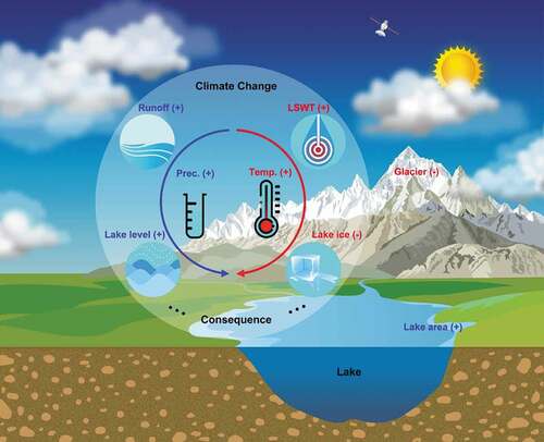
In this Rapid Communication, we present two ways in which lakes act as sentinels of climate change on the TP (). Firstly, changes in properties such as lake surface water temperature (LSWT) and lake ice phenology reflecting higher air temperature. Secondly, rising lake levels, expanding lake boundaries, and increases in lake volume, indicating a wetter climate driving increased land surface runoff and further consequences. We use Qinghai Lake, the largest lake (>4000 km2) on the TP, and the only one with a long-term record of hydrological observations, as a case study to demonstrate the changes that are occurring. We also point out the current gaps in studies of alpine lakes and how such gaps could be overcome using contemporary science.
Figure 1. Schematic illustrating climate change effects on lake variations over the Tibetan Plateau
One consequence of warmer air temperatures is an increase in LSWT. Some lakes have had a high warming rate due to increasing air and land surface temperatures, but others have cooled due to an increased glacier/snow meltwater supply (Wan et al., Citation2018; Zhang et al., Citation2014). Both warming and cooling LSWT can be the result of increasing air temperature (Zhang et al., Citation2014). The central-northern plateau lakes show an overall warming trend in contrast to the cooling trend of lakes in the south (Zhang et al., Citation2020). The air temperature record from the station closest to Qinghai Lake shows a warming rate of 0.03 ± 0.003 °C/yr (P < 0.001) between 1958 and 2019 (), while the surface water temperature for Qinghai Lake increased at a rate of 0.02 ± 0.005 °C/yr (P < 0.001) between 1967 and 2020. Warm extremes have been occurring with increasing frequency on the TP (Yin et al., Citation2019), and the resultant changes in LSWT could affect aquatic species and alter lake ecosystems (Woolway et al., Citation2021).
Figure 2. Warmer and wetter climate driving lake change, with Qinghai Lake as a case study, from 1956 to 2020. a) Air temperature (T) observed at Gangcha station from 1958 to 2019. b) Lake surface water temperature (LSWT) at Xiashe station from 1967 to 2020. c) Lake ice depth and lake ice duration at Xiashe station from 1994 to 2020. d) Precipitation (P) at Gangcha station from 1958 to 2019. e) Runoff at Buha station from 1956 to 2020. f) Lake level at Xiashe station from 1956 to 2020. g) Lake area from 1956 to 2020 estimated from the correlation constructed between lake area derived from Landsat images and lake level from gauge measurements in 2001 − 2020. The locations of stations are shown in Figure S2 in the supporting information. The correlation between lake area and level is shown in Figure S3
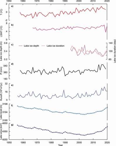
Lake ice can modulate climate and plays an important role in maintaining aquatic ecosystem health, but another result of increasing LSWT is a reduction in lake ice thickness and a shortening of lake ice duration (freeze-up end date to break-up start date). Changes in lake-ice duration over the TP were found to be heterogeneous, with ice-cover duration longer for lakes in the central-north plateau, compared to the southern lakes (Cai et al., Citation2019). Model simulations of different climate scenarios show that the plateau lake-ice duration will further shorten within the 21st century (Ruan et al., Citation2020). In-situ measurements of Qinghai Lake ice thickness reveal a thinning rate of 0.003 ± 0.0016 m/yr (P < 0.05) between 1994 and 2020, while the lake-ice duration shortened at a rate of 1.02 ± 0.23 days/yr (P < 0.005). This shorter lake-ice duration and the spatial heterogeneity in duration are dominantly driven by the rising temperatures of air, land and lake water (Zhang et al., Citation2020).
Precipitation over the TP in the last four decades also has an increasing trend, especially after 1998 (Zhang et al., Citation2020). The precipitation input to a lake consists of both the direct precipitation falling onto the lake surface and precipitation runoff from within the lake basin. During 1984 − 2006, simulated runoff at weather stations increased in the plateau interior (Yang et al., Citation2011). For example, the runoff at Buha station, in the largest catchment of Qinghai Lake basin, and the only hydrological station within endorheic lake basin on the TP with a long-term in situ measurement record available, shows an increasing trend from 1956 to 2020 (0.1 ± 0.03 × 10⁸ m3/yr, P < 0.05), which is generally consistent with the positive precipitation trend (3.5 ± 0.2 mm/yr, P < 0.001). This increased basin precipitation runoff implies more precipitation input into lakes and that basin size, or basin/lake size ratio, are also important factors associated with lake variation.
Changes in lake area, level, and volume can effectively indicate climate change over the TP as there are few direct human impacts on lake water balance in the region. There has been an expansion of ~25% in the area of the lakes, corresponding to a mean lake level rise of ~4 m, and a water storage gain of ~170 Gt over the past five decades (1970s−2020) (Zhang et al., Citation2021, Citation2020). Generally, the area, level and volume of lakes in the central-north plateau (>32°N) show increases, in contrast to the southern lakes (<32°N) which show decreases. The detailed evolution of lake levels is expected to be variable, due to the lakes being located in different climate zones and the variations in shoreline terrain control (Zhang et al., Citation2020). For example, annual observations of the water level of Qinghai Lake showed a decrease followed by an increase from 1956 to 2020. The lake level recovery, and subsequent increase, continued after 2004 (+3.47 m from 2004 to 2020 at a rate of 0.19 m/yr) and was robust in the last decade (0.26 m/yr during 2010 − 2020) Accordingly, the lake area underwent a contraction followed by expansion during 1956 − 2020. By 2020 the lake area (4522.7 km2) had recovered its early 1960s value (). The transitions of lake level and area, i.e. the increase before 2004 and decrease after that, are dominantly controlled by increased precipitation and river runoff, followed by decreased evaporation (Cui & Li, Citation2016; Dong et al., Citation2018; Fang et al., Citation2019; Tang et al., Citation2018).
The lake water balance over the TP has been evaluated both qualitatively and quantitatively (Zhang et al., Citation2020), revealing that it is increased precipitation, rather than glacier/snow melt, that contributes the largest component (>70%) of the lake water storage increase (Zhang et al., Citation2017). This finding is supported by satellite data from NASA’s Gravity Recovery and Climate Experiment (GRACE), which shows a terrestrial water storage increase of 6.4 ± 0.4 Gt/yr, P < 0.001) between 2003 and 2016 (Zhang et al., Citation2020). The lake variations can be used to indirectly imply and project the spatial patterns and trends of precipitation change, especially for the Inner TP, an endorheic basin. There is an expectation of continuous expansion of lake area over the TP until the end of this century with the increasing precipitation predicted for different scenarios (Chen et al., Citation2015). The expansion of lake area and the increase in water volume will have significant impacts on the surrounding ecological environment. The lakes over the TP store an important water resource, with a current volume of more than 1000 km3 (Messager et al., Citation2016; Zhang et al., Citation2021). The extensive lake area, and the associated large lake volume, could alter local and regional climate, and even produce extreme weather events in the surrounding areas.
The wide-ranging applications of multi-spectral/optical remote sensing data, laser/radar altimeters, and spaceborne gravimetry data have greatly increased our knowledge of lake changes, but there are still several important directions for future alpine lake studies to take: 1) lake heatwaves (periods of extreme high LSWT) (Woolway et al., Citation2021) for understanding the influence of climate extremes on vulnerable lake ecosystems. 2) reduced lake ice for under-ice ecosystem disturbance (Hampton et al., Citation2016). 3) estimating groundwater storage variations related to lake water changes. 4) lake water balance, especially the quantitative contribution from lake surface evaporation. 5) effects of lake changes on climate and the ecological environment. Remote sensing observations combined with field surveys and model simulations, and especially the ongoing Second TP Scientific Expedition and Research Plan will further promote our understanding of the lakes’ past state, future fate and effect.
Supplemental Material
Download MS Word (1.5 MB)Acknowledgments
The hydrology (lake surface water temperature, lake ice depth, lake ice duration, runoff, lake level, lake area) and climate (air temperature, precipitation) data of Qinghai Lake used in this study is available at Zenodo (https://zenodo.org/record/5762640) and TPDC (https://data.tpdc.ac.cn/en/data/12cb9320-e6ba-4938-a9ac-5b0ebb656825).
Disclosure statement
No potential conflict of interest was reported by the author.
Supplementary material
Supplemental data for this article can be accessed here.
Additional information
Funding
References
- Adrian, R., O’Reilly, C. M., Zagarese, H., Baines, S. B., Hessen, D. O., Keller, W., Livingstone, D. M., Sommaruga, R., Straile, D., Van Donk, E., Weyhenmeyer, G. A., & Winder, M. (2009). Lakes as sentinels of climate change. Limnology and Oceanography, 54(6), 2283–2297. https://doi.org/https://doi.org/10.4319/lo.2009.54.6_part_2.2283
- Cai, Y., Ke, C., Li, X., Zhang, G., Duan, Z., & Lee, H. (2019). Variations of lake ice phenology on the Tibetan Plateau from 2001 to 2017 based on MODIS data. Journal of Geophysical Research: Atmospheres, 124(2), 825–843. https://doi.org/https://doi.org/10.1029/2018JD028993
- Chen, D., Xu, B., Yao, T., Guo, Z., Cui, P, Chen, F., Zhang, R., Zhang, X., Zhang, Y., Fan, J., Hou, Z., & Zhang, T. (2015). Assessment of past, present and future environmental changes on the Tibetan Plateau. Chinese Science Bulletin, 60(32), 3025–3035. https://doi.org/https://doi.org/10.1360/N972014-01370
- Cui, B.-L., & Li, X.-Y. (2016). The impact of climate changes on water level of Qinghai Lake in China over the past 50 years. Hydrology Research, 47(2), 532–542. https://doi.org/https://doi.org/10.2166/nh.2015.237
- Dong, H., Song, Y., & Zhang, M. (2018). Hydrological trend of Qinghai Lake over the last 60 years: Driven by climate variations or human activities? Journal of Water and Climate Change, 10(3), 524–534. https://doi.org/https://doi.org/10.2166/wcc.2018.033
- Fang, J., Li, G., Rubinato, M., Ma, G., Zhou, J., Jia, G., Yu, X., & Wang, H. (2019). Analysis of long-term water level variations in Qinghai Lake in China. Water, 11(10), 2136. https://doi.org/https://doi.org/10.3390/w11102136
- Hampton, S. E., Galloway, A. W. E., Powers, S. M., Ozersky, T., Woo, K. H., Batt, R. D., Labou, S. G., O’Reilly, C. M., Sharma, S., Lottig, N. R., Stanley, E. H., North, R. L., Stockwell, J. D., Adrian, R., Weyhenmeyer, G. A., Arvola, L., Baulch, H. M., Bertani, I., Bowman, L. L., Carey, C. C., & Grover, J. (2016). Ecology under lake ice. Ecology Letters, 20(1), 98–111. https://doi.org/https://doi.org/10.1111/ele.12699
- Messager, M. L., Lehner, B., Grill, G., Nedeva, I., & Schmitt, O. (2016). Estimating the volume and age of water stored in global lakes using a geo-statistical approach. Nature Communications, 7, 13603. https://doi.org/https://doi.org/10.1038/ncomms13603
- Ruan, Y., Zhang, X., Xin, Q., Qiu, Y., & Sun, Y. (2020). Prediction and analysis of lake ice phenology dynamics under future climate scenarios across the inner Tibetan Plateau. Journal of Geophysical Research: Atmospheres, 125(23) : e2020JD033082). https://doi.org/https://doi.org/10.1029/2020jd033082
- Tang, L., Duan, X., Kong, F., Zhang, F., Zheng, Y., Li, Z., Mei, Y., Zhao, Y., & Hu, S. (2018). Influences of climate change on area variation of Qinghai Lake on Qinghai-Tibetan Plateau since 1980s. Scientific Reports, 8(1), 7331. https://doi.org/https://doi.org/10.1038/s41598-018-25683-3
- Wan, W., Zhao, L., Xie, H., Liu, B., Li, H., Cui, Y., Ma, Y., & Hong, Y. (2018). Lake surface water temperature change over the Tibetan Plateau from 2001 to 2015: A sensitive indicator of the warming climate. Geophysical Research Letters, 45(20), 11177–11186. https://doi.org/https://doi.org/10.1029/2018gl078601
- Woolway, R. I., Jennings, E., Shatwell, T., Golub, M., Pierson, D. C., & Maberly, S. C. (2021). Lake heatwaves under climate change. Nature, 589(7842), 402–407. https://doi.org/https://doi.org/10.1038/s41586-020-03119-1
- Yang, K., Ye, B., Zhou, D., Wu, B., Foken, T., Qin, J., & Zhou, Z. (2011). Response of hydrological cycle to recent climate changes in the Tibetan Plateau. Climatic Change, 109(3), 517–534. https://doi.org/https://doi.org/10.1007/s10584-011-0099-4
- Yin, H., Sun, Y., & Donat, M. G. (2019). Changes in temperature extremes on the Tibetan Plateau and their attribution. Environmental Research Letters, 14(12), 124015. https://doi.org/https://doi.org/10.1088/1748-9326/ab503c
- Zhang, G., Bolch, T., Chen, W., & Crétaux, J. F. (2021). Comprehensive estimation of lake volume changes on the Tibetan Plateau during 1976–2019 and basin-wide glacier contribution. Science of the Total Environment, 772, 145463. https://doi.org/https://doi.org/10.1016/j.scitotenv.2021.145463
- Zhang, G., Yao, T., Shum, C. K., Yi, S., Yang, K., Xie, H., Feng, W., Bolch, T., Wang, L., Behrangi, A., Zhang, H., Wang, W., Xiang, Y., & Yu, J. (2017). Lake volume and groundwater storage variations in Tibetan Plateau’s endorheic basin. Geophysical Research Letters, 44(11), 5550–5560. https://doi.org/https://doi.org/10.1002/2017GL073773
- Zhang, G., Yao, T., Xie, H., Qin, J., Ye, Q., Dai, Y., & Guo, R. (2014). Estimating surface temperature changes of lakes in the Tibetan Plateau using MODIS LST data. Journal of Geophysical Research: Atmospheres, 119(14), 8552–8567. https://doi.org/https://doi.org/10.1002/2014JD021615
- Zhang, G., Yao, T., Xie, H., Yang, K., Zhu, L., Shum, C. K., Bolch, T., Yi, S., Allen, S., Jiang, L., Chen, W., & Ke, C. (2020). Response of Tibetan Plateau lakes to climate change: Trends, patterns, and mechanisms. Earth-Science Reviews, 208, 103269. https://doi.org/https://doi.org/10.1016/j.earscirev.2020.103269