Abstract
Feitsui reservoir, the major water supply of Taipei city, has shown declining water quality in recent years. The reservoir is located in an area famous for tea cultivation, and the question arises as to whether the hillside tea plantations have contributed to increased sediment and nutrient discharge into the reservoir. In this study, soil and phosphorus redistribution were examined along a steep tea plantation in the reservoir's catchment and the provenance of reservoir sediment was assessed. Fallout radionuclides were used as soil erosion/deposition tracers and as markers of sediment sources. Continuous fertilizer application has raised (inorganic) phosphorus levels in the studied tea plantation. The plantation's narrow bench terraces trap eroded material and slow down soil and nutrient translocation. Nevertheless, eroded soil and phosphorus have accumulated on a vegetated toeslope below the tea plantation. The reservoir sediment contained significant amounts of inorganic phosphorus and cesium-137, and application of a mixing model resulted in a surface soil contribution of approximately 30%. This points towards tea plantations as possible sediment and pollutant sources and underlines the necessity of soil conservation strategies, such as the maintenance of vegetated riparian buffer zones. However, other sources, such as landslide debris and urban wastewaters, cannot be entirely ruled out. Further research is needed to better characterize the catchment's soils and sediments and to improve sediment fingerprinting efforts. Potential point and non-point pollution sources need to be examined in detail to better understand how phosphorus enters the reservoir.
Key words:
INTRODUCTION
Soil erosion and associated downstream water pollution can pose severe threats to aquatic ecosystems. In Taiwan, water for the densely populated coastal plains is primarily supplied by upland reservoirs. However, many of these reservoirs have suffered from eutrophication in recent years (CitationChang and Chuang 2001), and rapid reservoir siltation has repeatedly attracted media attention (e.g. Taipei Times, 10 September 2004, p. 2). In addition to natural factors favoring high erosion rates, such as steep topography, frequent earthquakes and intense rainfalls, human disturbances have increasingly impacted on Taiwan's water reservoirs. Agricultural activities and urban development in upstream areas have increased soil erosion and impaired downstream water quality (CitationLin and Hsieh 2003; CitationLu et al. 2001). In many reservoirs of Taiwan, phosphorus (P) is the primary limiting nutrient (CitationChang and Chuang 2001), and anoxic release of sediment-bound P has been identified as the cause of recent water-quality deterioration (CitationChen and Wu 2003). Because of the strong association of P with the solid soil phase (CitationLogan 2000), the primary pathway of its movement in the landscape is through particulate transport. Thus, soil erosion and sedimentation are a likely cause of P input into water reservoirs.
Fallout radionuclides have been extensively used in soil erosion and sedimentation research over the past decades, as reviewed by CitationRitchie and McHenry (1990) and CitationZapata (2003). The combined use of cesium-137 (137Cs, half-life: 30.2 years) and excess lead-210 (210Pbex, half-life: 22.3 years) offers the opportunity of tracing soil erosion and sedimentation over different time scales (∼40 and ∼100 years, respectively), as demonstrated for example by CitationOwens and Walling (2002) and CitationMizugaki et al. (2006). In recent years, radionuclides have received increasing attention as indicators of soil erosion processes and as sediment source tracers (e.g. CitationLi et al. 2003; CitationZhang and Walling 2005). Because fallout radionuclides accumulate close to the soil surface, their concentrations in sediment samples can provide information on the relative importance of surface versus subsoil sources.
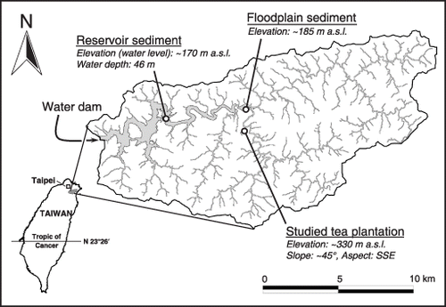
Figure 1 Catchment of the Feitsui reservoir showing the three sampling locations.
The Feitsui reservoir, which supplies water to the Taipei metropolitan area, has come under increased scrutiny in recent years because of deteriorating water quality (CitationChen and Wu 2003; CitationKuo et al. 2003). The reservoir's catchment area is famous for its tea production, and the question arises whether the steep hillside tea plantations cause increased sediment and nutrient discharge into the reservoir. Unfortunately, information about soil erosion under tea cultivation is very scarce. The objective of this study was, therefore, to investigate soil and P redistribution along a representative tea plantation in the Feitsui reservoir's catchment and to assess the provenance of reservoir sediment using fallout radionuclides as tracers.
MATERIALS AND METHODS
Study area
The Feitsui reservoir is located on Peishi creek, in the upstream part of the Tamsui catchment in northern Taiwan (). The reservoir was completed in 1987 with a gross initial storage capacity of 406 × 106 m3. Its main purpose is the supply of domestic water to over 5 million people in the Taipei metropolitan area. The reservoir has a surface area of 10.2 km2, and its normal high-water level is at 170 m a.s.l.; the reservoir's catchment extends to approximately 900 m a.s.l. covering an area of 303 km2. The topography is steep, with 91, 63 and 25% of the land surface exceeding slope gradients of 10°, 20° and 30°, respectively. The mean annual precipitation in the catchment is in excess of 3,700 mm. The underlying geology is dominated by argillite and slate with sandstone interbeds, and the soils are Entisols and Inceptisols (CitationSoil Survey Staff 2006) with high silt contents. Montane forest covers approximately 93% of the catchment land area, 5% is under agricultural land use and < 1% is residential areas and roads.
Soil and sediment sampling
Soil samples were collected in the Pinglin area, close to the confluence of the main tributary streams, where many slopes are under tea cultivation. A representative tea plantation located on a terraced 45° slope was selected for this study (). In addition, a densely vegetated, level reference site, located less than 100 m from the studied plantation, was analyzed. On the terraced tea slope, an approximately 5-m wide transect was studied from the top, along the narrow bench terraces, down to a vegetated toeslope (). Soil samples were taken in the middle of the bench terraces. Three types of soil samples were collected. (1) Composite topsoil samples: 10 samples were taken from the 0–10 cm layer with a trowel and mixed to obtain one composite sample for each site. (2) Depth profile soil cores: a manually operated stainless steel probe that was lined with a polyethylene tube inside (34 cm length; 3.4 cm internal diameter) was used to take soil cores to a depth of approximately 30 cm or until further penetration was restricted by the rocky soil parent material. Duplicate cores were taken 1 m apart, sliced at 3-cm intervals and combined to yield one sample for each 3-cm increment. (3) Total inventory soil cores: between 5 and 15 cores were taken using the same sampling technique without slicing into depth increments.
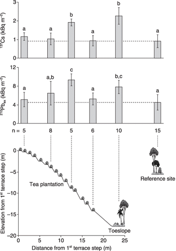
Figure 2 Cross-section of the studied tea plantation and total radionuclide inventories along the slope (n, number of replicate soil cores). Error bars represent standard deviation and the letters a, b and c indicate statistically significant differences (anova, Duncan's test, α = 0.05).
Sediment cores were taken on a floodplain immediately upstream of the reservoir lake () using the soil-coring device described above. Reservoir bottom sediment was collected roughly in the middle of the reservoir () at a water depth of 46 m, using a coring tube with a 6 cm internal diameter. All samples were oven-dried at 80°C and sieved to 2 mm prior to laboratory analyses.
Laboratory analyses
Electrical conductivity (EC) and pH were measured in H2O at a 1:2.5 solid : solution ratio after 12 h of equilibration (CitationBlum et al. 1996). Particle size distribution was determined with a combined sieve and pipette method after removal of organic matter with hydrogen peroxide and dispersion by reciprocal shaking with sodium metaphosphate solution for 12 h (CitationSoil Survey Staff 2004). The amount of water vapor adsorbed on soil and sediment samples at 19% relative humidity ([RH] maintained by a saturated CaBr2 solution at 20°C) was determined and used as an indicator of the samples’ surface extent (CitationQuirk and Murray 1999). Total carbon (C) and nitrogen (N) were determined by dry combustion (CitationTabatabai and Bremner 1991); the obtained C values were assumed to correspond to organic C because the studied soils and sediments did not contain carbonate minerals. Exchangeable potassium (K) was extracted with unbuffered 0.1 mol L−1 BaCl2 at a solid : solution ratio of 1:20 (CitationBlum et al. 1996). Phosphorus (P) was extracted with 0.5 mol L−1 H2SO4 (solid : solution ratio of 1:25) before and after ignition at 550°C (CitationKuo 1996). Inorganic P was assumed to correspond to P extracted from the unignited samples, and organic P was calculated as the difference between P extracted from the ignited and unignited samples. Extracted P and K were measured using inductively coupled plasma-mass spectrometry (ICP-MS).
Three HPGe detectors (ORTEC GMX-100230), each interfaced to a stand-alone digital gamma-ray spectrometer (DSPec Plus), were used to measure radionuclide activities. The detectors have an efficiency of 100% relative to a 3 × 3 NaI detector. Absolute counting efficiencies of the detectors were calibrated using NIST SRM 4353 (Rocky Flat soil) and IAEA standard soils 327 and 375. 210Pb (46.52 keV), 137Cs (661.62 keV) and 214Pb (351.99 keV) were measured. 214Pb was used to obtain supported 210Pb resulting from 238U decay in the soil. Supported 210Pb was subtracted from total 210Pb to obtain excess 210Pb (210Pbex) from atmospheric deposition.
Calculations
Enrichment/depletion factors arising from size-selective erosion, transport and deposition processes were calculated following the relationship described by CitationHe and Walling (1996):
where Ren is the enrichment/depletion ratio, Ssp is the specific surface area of the sediment and S is the average specific surface area of the source material. The ratio Ssp/S was estimated by the ratio of H2O adsorbed at 19% RH on the sediment relative to the source material (CitationQuirk and Murray 1999).
The relative contributions of surface and channel/subsoil sources, respectively, to the reservoir sediment were calculated using a simple mixing model described by CitationZhang and Walling (2005):
where Cdn is the 137Cs activity of the reservoir sediment, Ps and Pb are the relative contributions from surface and channel/subsoil sources, respectively, and Cs and Cb are the 137Cs activities associated with sediment inputs to the reservoir derived from surface and channel/subsoil sources in the catchment, respectively.
RESULTS AND DISCUSSION
Soil redistribution: Evidence from fallout radionuclides
The fallout radionuclides 137Cs and 210Pbex have a strong affinity for the solid soil phase, especially for the surfaces of fine-grained particles (CitationHe and Walling 1996). As a consequence, their redistribution in the landscape is largely controlled by soil erosion and deposition processes. Because of their decadal-scale half lives, both radionuclides allow for retrospective estimation of medium-term erosion and deposition rates. Assuming equal radionuclide fallout within a small study area, any deviation from the inventory of an undisturbed and level reference site may be interpreted in terms of erosional loss or depositional gain. These processes also manifest themselves in characteristic depth distributions of the radionuclides within soil profiles.
and show the depth distributions of 137Cs and 210Pbex, respectively, at the reference site, on a terrace in the tea plantation and on the toeslope (). The reference site had a sharp sub-surface peak of 137Cs followed by an exponential decrease with depth, and an exponential decrease of 210Pbex from the surface downwards. The different depth distributions of 137Cs and 210Pbex are likely to result from different fallout patterns. 137Cs had its fallout maximum in 1963 and has since migrated downwards in the soil profile, while 210Pbex has continuously been deposited onto the soil surface. In both cases, most of the radionuclide activity was confined to the upper 10 cm of the soil profile (, ). The observed patterns are typical of an undisturbed site and an indication that the selected location qualifies as a reference site.
In the tea plantation, the radionuclide depth distributions were different. 137Cs showed a deeper and broader maximum, whereas 210Pbex showed a distinct surface maximum followed by a more uniform subsurface distribution. Both radionuclides extended to greater depths (, ). High rock content restricted coring at this location; however, we have evidence that 137Cs activities sharply decrease below 25 cm (data not shown). The deeper maximum in the 137Cs profile may reflect a buried soil surface, thus, indicating deposition of eroded material at this site. The more uniform profile shape may be the result of deep mixing, possibly during the replanting of the tea bushes, which is done every 5–10 years. The distinct 210Pbex surface maximum is likely to result from continuous fallout of this natural radionuclide onto the soil surface since the last replanting, which had homogenized its depth distribution, as well as from deposition of eroded topsoil material with high 210Pbex (and moderate 137Cs) activities.
Figure 3 Depth distribution of 137Cs at different landscape positions, and 137Cs activity in the sediments. Error bars represent the standard deviation of three subsamples.
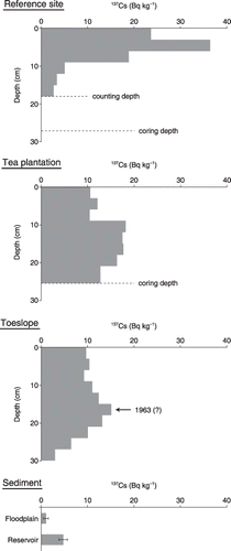
Figure 4 Depth distribution of 210Pbex at different landscape positions, and 210Pbex activity in the sediments. Error bars represent the standard deviation of three subsamples.
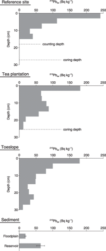
The toeslope immediately below the terraced plantation is an obvious accumulation area because of its landscape position and dense vegetation (). The radionuclide depth distributions clearly reflect this situation. 137Cs showed a well-defined peak 15–18 cm from the surface, which could be associated with the 137Cs fallout maximum in 1963, and 210Pbex showed an exponential decline from the surface. Both radionuclides were detected, albeit at low activities, down to 30 cm (, ).
For a more quantitative understanding, total 137Cs and 210Pbex inventories along the studied tea slope were compared to those at the reference site. The results are presented in . The examined tea terraces had total inventories equal to or higher than the reference site, which indicates a tendency towards a net gain of material. This shows that despite the steepness of the overall slope, the terrace steps act as small deposition sites that trap eroded soil originating from the above terrace steps and terrace walls. On the toeslope, the total inventories were significantly elevated, indicating deposition of eroded material. This is likely to result from the combined effects of an abruptly flattening slope and dense vegetation cover. The mean 137Cs inventory at the reference site was approximately 40% of that on the toeslope (); and approximately 40% of the 137Cs in the toeslope profile was found below the peak (), which, therefore, seems to be a marker of the soil surface during the 1963 fallout maximum of 137Cs. From this, an average deposition rate of 3.6 mm year−1 can be calculated for the toeslope area below the tea plantation, which is in the same order of magnitude as the average soil erosion rates in the catchment (2–3 mm year−1; estimated by CitationDadson (2004) from reservoir-fill data).
Very little information is available on soil erosion in tea plantations. Early studies by CitationOthieno (1975) and CitationOthieno and Laycock (1977) showed that while fields of young tea were susceptible to soil erosion, increasing canopy cover markedly reduced the erosion risk over time. CitationZhang et al. (2003) reported high soil erosion rates in a tea plantation in China. In contrast, CitationPoudel et al. (2000) used tea plants in contour hedgerows to effectively reduce steepland erosion in the Philippines. Whether or not soil erosion under tea cultivation reaches critical levels is likely to depend on the specific situation. In the area under study, many tea plantations are on steep slopes and rains can be torrential, which would favor soil erosion. However, the plantations are usually terraced similar to the studied example (), which creates a number of potential traps for material in active transport. However, soil erosion may be exacerbated by agricultural operations that cause disturbance to the soil surface, such as the replanting of tea bushes. Vegetated toeslope areas can trap eroded soil, as observed in the present study, and can act as barriers for sediment transport to tributary streams.
Table 1 Chemical and physical properties of the studied soils and sediments
Soil and sediment properties and phosphorus redistribution
The chemical and physical characteristics of the studied soils and sediments are shown in . Soil pH values were very low, which is common under tea cultivation. The EC was elevated in the tea plantation relative to the forested reference and toeslope sites (). This likely reflects the addition of soluble salts through fertilizer application on the tea terraces (farmers generally topdress inorganic fertilizers three times per year). The remarkably high EC of the reservoir sediment () might result from an accumulation of soluble salts in the reservoir, which represents an artificial sink in the landscape. The studied soils had high silt contents and fall into the “clay loam” and “silty clay loam” textural classes (CitationSoil Survey Staff 2006). In the floodplain sediment, the sand fraction dominated, and in the reservoir sediment, the silt fraction was enriched (). This is likely to be the result of size-selective transport and sedimentation processes: the coarser fractions are deposited in upstream areas, where flow velocities are higher, whereas the finer fractions are flushed farther into the reservoir lake (). Organic C and total N contents were highest at the reference site, showed relatively high levels in the tea plantation, but were considerably lower in the floodplain and reservoir sediment samples (). The surface extent of the studied samples, expressed as the amount of H2O adsorbed at 19% RH (CitationQuirk and Murray 1999), increased with increasing clay and organic matter contents (). Exchangeable K was higher in the tea plantation compared to the reference and toeslope areas (), which is likely to result from fertilizer-K application.
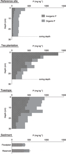
shows the depth distributions of inorganic and organic P at the reference site, on a terrace in the tea plantation and on the toeslope (), and compares these to the levels found in the floodplain and reservoir sediment samples. At the reference site, P contents were comparatively low and dominated by organic forms (; ). Phosphorus decreased logarithmically from the soil surface to near constant levels below a depth of approximately 10 cm (). In the tea plantation, continuous fertilization (35–50 kg P ha−1 year−1 applied as calcium phosphate) has led to a build-up of P with a clear dominance of inorganic forms (; ). The P levels showed a logarithmic decrease from the soil surface and were, relative to the reference site, elevated throughout the profile (). On the toeslope, P seemed to have accumulated from the upslope tea plantation, resulting in clearly elevated levels relative to the reference site (; ). Phosphorus contents showed a linear decrease with depth and were comprised of substantial quantities of both inorganic and organic forms (). Evidently, the dense vegetation of the toeslope readily converts deposited inorganic P into organic forms. It is interesting to note that in the upper half of the profile inorganic P > organic P, whereas in the lower half organic P > inorganic P (). This might be the result of increasing application rates of inorganic fertilizers during the past decades. Both the floodplain and reservoir sediment samples showed considerable and predominantly inorganic P levels (; ). The sediment-P might originate from upstream tea plantations, especially where downslope/riparian buffer areas are insufficient or missing. However, P could also have entered the tributary streams with urban wastewaters and subsequently been sorbed onto suspended sediment particles.
Figure 5 Depth distribution of inorganic and organic phosphorus (P) at different landscape positions, and P concentration in the sediments. Error bars represent the standard deviation of three subsamples.
Reservoir sediment sources
Where do the sediments and associated pollutants that enter the Feitsui reservoir come from? While this is a rather complex issue, fallout radionuclides may give some clues as to the contribution of surface versus subsoil sources. 137Cs and 210Pbex have been used to estimate the relative importance of sheet and rill erosion versus gully and channel erosion (e.g. CitationLi et al. 2003; CitationZhang and Walling 2005). However, fallout radionuclides in lacustrine sediments are composed of a portion that enters the lake with sediment from the catchment and a portion that is deposited directly onto the lake surface and scavenged by particulate matter in the water column. The mean atmospheric flux of 210Pb in the Taipei area amounted to 2.5 ± 0.8 d.p.m. cm−2 year−1 between 1996 and 2005 (CitationHuh et al. 2006), but no fallout of 137Cs has been detected in recent years (CitationHuh and Su 2004). This is consistent with the modeled 137Cs fallout history in eastern China (CitationLu and Higgitt 2000) and with measured 137Cs fallout in Japan (CitationMizugaki et al. 2006), where negligible 137Cs fluxes were reported after the Chernobyl fallout of 1986. Since the Feitsui reservoir was completed in 1987, it appears safe to assume that 137Cs encountered in the reservoir sediment originated from surface soils in the reservoir's catchment.
shows that 137Cs could clearly be detected in the reservoir sediment. For a quantitative comparison with the soils, changes in 137Cs activity resulting from particle size selectivity of erosion, transport and deposition processes have to be accounted for. Enrichment/depletion ratios were estimated according to Eq. Equation1 and indicated a 137Cs depletion of the reservoir sediment relative to the soils, with ratios of between 0.59 and 0.77 (). Multiplication of the 137Cs activity in the reservoir sediment (4.8 Bq kg−1) by the inverse of these ratios yields values of between 6.2 and 8.1 Bq kg−1, which places the sediment samples closer to the studied surface soils (). This indicates that a significant portion of the reservoir sediment originates from surface sources. The application of a simple mixing model (Eqs Equation2, Equation3) resulted in a surface source contribution of 31% if the upper 9 cm of the reference profile (mean 137Cs activity: 26.2 Bq kg−1) was considered to be surface source materials and sediment originating from channel or subsoil sources was assumed to be devoid of 137Cs. Although this provides a first estimate of the contribution of surface soils to sediment discharge into the Feitsui reservoir, it needs to be interpreted with caution in light of the still limited characterization of the catchment's soils and sediments.
Despite the effectiveness of bench terraces in trapping eroded soil, tea plantations are potential source areas, especially where they are located close to the reservoir or to tributary streams, with insufficient downslope/riparian buffer zones. We have encountered signs of slope-parallel sheet erosion on slightly inclined tea terraces, with sediments delivered out to footpaths, and from there downslope towards the reservoir. However, landslides and debris flows, often triggered by earthquakes and typhoons, are naturally occurring phenomena in the Taiwan mountain belt (e.g. CitationDadson et al. 2004; CitationLin et al. 2003; CitationWang et al. 2003), and reservoir sediment with significant 137Cs activities could conceivably also originate from shallow landslides.
CONCLUSIONS
In the studied hillside tea plantation, continuous fertilizer application has built-up (inorganic) P levels. The plantation's narrow bench terraces trap eroded material and impede downward translocation of soil and nutrients. However, over time, eroded soil and P have accumulated on the toeslope area below the tea plantation. Soil erosion is likely aggravated episodically by invasive agricultural operations, such as the replanting of tea bushes. The vegetated toeslope is an important barrier for sediment and P transport into tributary streams.
The reservoir sediment had relatively high and predominantly inorganic P levels and significant 137Cs activities, the latter indicating surface provenance. This directs attention to the many tea plantations in the catchment area as possible sediment and pollutant sources, and underlines the necessity of soil conservations strategies, especially in proximity to the reservoir and tributary streams. However, surface material could also have been delivered to the reservoir by shallow landslides, and inorganic P could also have entered the tributary streams with urban wastewaters.
This study provides preliminary information on soil and P redistribution in a catchment of top priority to decision makers in Taiwan. Further research is needed to better characterize the catchment's soils and sediments, covering its various altitudinal zones, slope gradients and land-use types. The combined use of several diagnostic sediment/source properties (composite fingerprinting; e.g. CitationCollins et al. 1997) could then yield improved estimates of sediment provenance. Finally, additional investigations that consider point and non-point source pollution are needed to better understand how P enters the reservoir.
ACKNOWLEDGMENTS
This study was initiated during the first author's stay at the Institute of Earth Sciences, Academia Sinica, Taipei. The first author would like to cordially thank the institute's director, Professor Bor-Ming Jahn, for his help, support and understanding. The collaborative efforts were promoted through support granted by the Taipei Economic and Cultural Office in Vienna.
Related Research Data
References
- Blum , WEH , Spiegel , H and Wenzel , WW . 1996 . Bodenzustandsinventur , 2nd edn , Vienna : Bundesministerium für Land und Forstwirtschaft, Bundesministerium für Wissenschaft, Verkehr und Kunst .
- Chang , SP and Chuang , SM . 2001 . "Eutrophication study of twenty reservoirs in Taiwan . Water Sci. Technol. , 44 : 19 – 26 .
- Chen , YJ and Wu , SC . 2003 . "Effects of sediment phosphorus release associated with the density current on water quality of a subtropical and deep reservoir in Taiwan . Water Sci. Technol. , 48 : 151 – 158 .
- Collins , AL , Walling , DE and Leeks , GJL . 1997 . "Source type ascription for fluvial suspended sediment based on a quantitative composite fingerprinting technique . Catena , 29 : 1 – 27 .
- Dadson , SJ . 2004 . "Erosion of an Active Mountain Belt ” . Cambridge, UK : The University of Cambridge . (PhD dissertation)
- Dadson , SJ , Hovius , N Chen , H . 2004 . "Earthquake-triggered increase in sediment delivery from an active mountain belt . Geology , 32 : 733 – 736 .
- He , Q and Walling , DE . 1996 . "Interpreting particle size effects in the adsorption of 137Cs and unsupported 210Pb by mineral soils and sediments . J. Environ. Radioact. , 30 : 117 – 137 .
- Huh , CA and Su , CC . 2004 . "Distribution of fallout radionuclides (7Be, 137Cs, 210Pb and 239,240Pu) in soils of Taiwan . J. Environ. Radioact. , 77 : 87 – 100 .
- Huh , CA , Su , CC and Shiau , LJ . 2006 . "Factors controlling temporal and spatial variations of atmospheric deposition of 7Be and 210Pb in northern Taiwan . J. Geophys. Res. , 111 : D16304 doi: 10.1029/2006JD007180
- Kuo , JT , Liu , WC Lin , RT . 2003 . "Water quality modeling for the Feitsui reservoir in northern Taiwan . J. Am. Water Resour. Assoc. , 39 : 671 – 687 .
- Kuo , S . 1996 . "Phosphorus ” . In Methods of Soil Analysis. Part 3–Chemical Methods , SSSA Book Series 5 Edited by: Sparks , DL . 869 – 919 . Madison : Soil Science Society of America-American Society of Agronomy .
- Li , Y , Poesen , J , Yang , JC , Fu , B and Zhang , JH . 2003 . "Evaluating gully erosion using 137Cs and 210Pb/137Cs ratio in a reservoir catchment . Soil Tillage Res. , 69 : 107 – 115 .
- Lin , CW , Shieh , CL , Yuan , BD , Shieh , YC , Liu , SH and Lee , SY . 2003 . "Impact of Chi-Chi earthquake on the occurrence of landslides and debris flows: example from the Chenyulan River watershed, Nantou, Taiwan . Eng. Geol. , 71 : 49 – 61 .
- Lin , JY and Hsieh , CD . 2003 . "A strategy for implementing BMPs for controlling nonpoint source pollution: the case of the Fei-tsui reservoir watershed in Taiwan . J. Am. Water Resour. Assoc. , 39 : 401 – 412 .
- Logan , TJ . 2000 . "Soils and environmental quality ” . In Handbook of Soil Science , Edited by: Sumner , ME . G155 – G169 . Boca Raton : CRC Press .
- Lu , SY , Cheng , JD and Brooks , KN . 2001 . "Managing forests for watershed protection in Taiwan . For. Ecol. Manage. , 143 : 77 – 85 .
- Lu , XX and Higgitt , DL . 2000 . "Estimating erosion rates on sloping agricultural land in the Yangtze Three Gorges, China, from caesium-137 measurements . Catena , 39 : 33 – 51 .
- Mizugaki , S , Nakamura , F and Araya , T . 2006 . "Using dendrogeomorphology and 137Cs and 210Pb radiochronology to estimate recent changes in sedimentation rates in Kushiro Mire, Northern Japan, resulting from land use change and river channelization . Catena , 68 : 25 – 40 .
- Othieno , CO . 1975 . "Surface run-off and soil erosion on fields of young tea . Trop. Agric. , 52 : 299 – 308 .
- Othieno , CO and Laycock , DH . 1977 . "Factors affecting soil erosion within tea fields . Trop. Agric. , 54 : 323 – 330 .
- Owens , PN and Walling , DE . 2002 . "Changes in sediment sources and floodplain deposition rates in the catchment of the river Tweed, Scotland, over the last 100 years: the impact of climate and land use change . Earth Surf. Process. Landforms , 27 : 403 – 423 .
- Poudel , DD , Midmore , DJ and West , LT . 2000 . "Farmer participatory research to minimize soil erosion on steepland vegetable systems in the Philippines . Agric. Ecosyst. Environ. , 79 : 113 – 127 .
- Quirk , JP and Murray , RS . 1999 . "Appraisal of the ethylene glycol monoethyl ether method for measuring hydratable surface area of clays and soils . Soil Sci. Soc. Am. J. , 63 : 839 – 849 .
- Ritchie , JC and McHenry , JR . 1990 . "Application of radioactive fallout cesium-137 for measuring soil erosion and sediment accumulation rates and patterns: a review . J. Environ. Qual. , 19 : 215 – 233 .
- Soil Survey Staff . 2004 . Soil Survey Laboratory Methods Manual , Soil Survey Investigations Rep. 42 Washington : United States Department of Agriculture-Natural Resources Conservation Science .
- Soil Survey Staff . 2006 . Keys to Soil Taxonomy, , 10th edn , Washington : United States Department of Agriculture-Natural Resources Conservation Science .
- Tabatabai , MA and Bremner , JM . 1991 . "Automated instruments for determination of total carbon, nitrogen, and sulfur in soils by combustion techniques ” . In Soil Analysis , Edited by: Smith , KA . 261 – 286 . New York : Marcel Dekker .
- Wang , WN , Wu , HL , Nakamura , H , Wu , SC , Ouyang , S and Yu , MF . 2003 . "Mass movements caused by recent tectonic activity: the 1999 Chi-chi earthquake in central Taiwan . Isl. Arc. , 12 : 325 – 334 .
- Zapata , F . 2003 . "The use of environmental radionuclides as tracers in soil erosion and sedimentation investigations: recent advances and future developments . Soil Tillage Res. , 69 : 3 – 13 .
- Zhang , X and Walling , DE . 2005 . "Characterizing land surface erosion from cesium-137 profiles in lake and reservoir sediments . J. Environ. Qual. , 34 : 514 – 523 .
- Zhang , Y , Yang , H , Du , MY , Tang , XY , Zhang , H and Peng , BZ . 2003 . "Soil erosion study on hillside in southern Jiangsu Province using the cesium-137 tracer technique . Soil Sci. Plant Nutr. , 49 : 85 – 92 .