Abstract
Planning has traditionally taught 3D visualisation as one of a number of technical tools that help equip students for the workplace. The aim of this paper is to explore how the learning possibilities of 3D visualisation can be extended through virtual worlds. In particular we detail the background and results of a study that examines how a unit on Sustainable Urban Regions used Second Life to teach students about urban accessibility through the framework of Crime Prevention through Environmental Design in 2009. Second Life was found to be useful to teach an aspect of planning that would normally not be accessible in a classroom. We propose that Second Life can be useful to help students question their assumptions about planning. The results also highlight some of the pitfalls that educators can avoid when teaching planning using virtual worlds and technology more generally.
Introduction
Planning as an activity concerned with the future is partially based on the communication of a virtual world. Planners are taught different skills to communicate this virtual world, such as design and map-making. Map-making is generally taught through classes in Geographic Information Systems (GIS), a computer system for analysing and displaying cartographic information. Proficiency in GIS skills has become an important element in most planning curricula as well as a selection criteria for most planning jobs. As the most technological component of a planning course, GIS classes have been a natural home for the teaching of three-dimensional (3D) visualisation, the visual representation of the three dimensions of the urban form on a screen.
However, the possibilities of teaching using 3D visualisation have been hampered by an instrumental vision of its pedagogical role as well as a limited take-up of the technology by educators. 3D visualisation has been mainly taught as one of a number of specific tools that students could cite knowledge of to increase their marketability in the workplace, despite 3D visualisation skills remaining in potential rather than actual demand. In a limited number of cases, students have also been taught to use 3D visualisation for a specific subject, for example, to provide an assessment in an urban design class (CitationYin, 2010). The possibilities of 3D visualisation have been limited by the need to purchase costly software and the technical nature of the activity (CitationYin, 2010).
In a range of disciplines, the confinement of 3D visualisation to teaching that already relies heavily on computing has been disrupted by the possibilities of freely available online virtual worlds such as Second Life. The comparative ease of use and cheapness of Second Life has encouraged pedagogical experiments in disciplines that would normally have ignored 3D visualisation as a useful contribution to a programme. These include disciplines such as law and cultural studies (CitationBayne, 2008), where the previous use of 3D visualisation would have been confined to a few courageous early adopters at most. A large amount of research has been written about these experiments in virtual worlds, with the prominent journals ALT-J (Vol 16 (3) 2008) and the British Journal of Education Technology (Vol 40 (3) 2009) for example, recently featuring special issues on Second Life.
Despite some similar recent experiments in planning education (e.g. CitationHollander and Thomas, 2009) and debate about the possibilities of teaching using virtual worlds (CitationSteins, 2007; CitationHorne and Thompson, 2008) the contribution that virtual worlds can make to education across geographical and design disciplines remains under-researched. We would conjecture that this is because the 3D visualisation within virtual worlds is too easily associated with existing technologies in planning education such as GIS and is seen as mainly applicable to a studio course. The aim of this paper is to argue for and explore other applications of virtual worlds in planning education that go beyond using it in a planning methods or a design studio context. In particular we argue that virtual worlds can provide affordances in planning which are not in the context of studio teaching.
In the following we briefly describe the history of planning and virtual worlds. We then use a literature search of journals, books and internet sources and participation in a virtual world to develop examples of the affordances of our chosen virtual world. For this exercise we chose Second Life and our work also draws on participation in Second Life-based discussion groups. We then propose ways in which Second Life can be used for teaching planning that go beyond studio teaching. In particular, we detail how Second Life was used in a postgraduate teaching unit in Sustainable Urban Regions to help students understand Crime Prevention Through Environmental Design (CPTED). Finally, we reflect on the outcomes of this pilot study and propose a specific, cheap and effective use of virtual worlds in teaching planning.
Our approach is deliberately exploratory and heuristic, paralleling the educators that CitationMinocha and Reeves (2010) identify, who try to reach an understanding of the affordances of a virtual world before designing a learning activity. This is in contrast to the more conventional approach of having pedagogy drive the design of learning spaces (CitationGibbs and Gosper, 2006).
Planning and virtual worlds
During the last 40 years there has been a combined development in mapping and visualisation using computers. Since the 1970s the use of GIS has expanded in line with the availability of data and the speed of computers (CitationBishop, 2000, p.111; CitationPeters, 2008). The revolution in computing has allowed most local government in the US for example, to acquire GIS and the production of the maps from these systems has developed into its own specialist sub-discipline (CitationO'Looney, 2000).
In parallel with the development of GIS, researchers have explored visualisations to portray the contours of landforms and the built environment in three dimensions. Researchers have strived to develop more accurate and ‘lifelike’ models in this area to inform stakeholders. They have used techniques developed in virtual reality research, which involve a complete sensorial immersion in a computer-generated space, to inform stakeholders, assuming that this will empower stakeholders as part of the decision-making process (CitationLange, 1994; CitationKoll-Schretzenmayr et al., 2004; CitationKrygier, 1999; CitationKingston et. al., 2000; CitationGonzalez et al., 2008). CitationWissen et al. (2008) for example, provide evidence that visualising indicators of landscape change can help stakeholders understand processes of change in the environment, animating them ‘to set up cause-and-effect chains’ (p. 194).
In teaching using early virtual world technology, the discovery of previously unnoticed cause and effect chains has also been noted. CitationIshii et al. (2002) for example, describe the development of a ‘luminous table’, a design tool for allowing the seamless manipulation of physical objects, drawings and computer images. While this tool afforded students the ability to recognise problems that had been previously overlooked, its applicability was limited because it required a dedicated set-up.
Despite some vaunted examples of 3D visualisation, the expense and difficulty of using them has meant that their take up has been limited. A number of works have argued that the advent of virtual worlds such as Second Life will change this take-up rate (CitationSteins, 2007; CitationHorne and Thompson, 2008; CitationGordon and Koo, 2008; CitationFoth et al., 2009). In the following we describe why Second Life could have an application in teaching planning.
Contextualising virtual worlds in planning education
In her review of planning education, CitationFrank (2006) outlines the role of different approaches in teaching planning over three decades. CitationFrank (2006) divides planning pedagogy into workshops and studios; work-based learning; role play and simulations; multimedia; online e-learning and other approaches such as field visits. We would argue that virtual worlds can be used with some of these approaches, and that in each case the application is quite specific. Workshops or studios are mainly used to teach practical, project-oriented skills. Therefore the function of a virtual world would be to teach practical virtual world building skills. This in fact may not represent a practical use of virtual worlds as, at present, skills in virtual world building are not relevant for much day to day planning activity. While 3D visualisation skills may be needed in some cases, these can be taught as an extension to an existing GIS course. Should a general primer or introduction to 3D building skills become necessary, training in the use of a cheap and easily accessible software such as Google sketchup makes more sense than a virtual world.
Virtual worlds could be used to provide some context and appropriate setting for role play, e.g. Citationde Freitas (2006), where students can develop and practice skills for transfer to real life situations (CitationNew Media Consortium, 2007). As CitationFrank (2006) points out, role plays are used to bring an element of realism into the classroom and are used to simulate negotiation and dispute resolution for example. Virtual worlds could be used to simulate rich context for the role playing activity, such as areas of the city which would not be accessible to students in real life. As CitationFrank (2006) notes, some educators have started using multimedia (especially films) to teach planning. Virtual worlds offer students the ability to create and edit films, which could provide an innovative approach to assessing graduate capabilities such as evaluation, synthesis, critical and creative thinking within a course on films and planning. Finally, the online and networked characteristic of virtual worlds makes them available for e-learning, in particular providing a 3D setting for distance learners ().
Table 1 Suggested uses of virtual worlds (VWs) in planning educationTable Footnote
Second Life and planning
In order to explore the affordances of virtual worlds, Second Life was chosen as an example to be trialled in a planning education context. Second Life is a computer generated physical space that can be experienced by several people at once. It combines the accessibility of the internet with the graphics of 3D visualisation, allowing participants to move and interact with each other in a fictional landscape using a character called an avatar. Avatars can purchase land for Linden dollars (L$). They can place textured shapes or objects on the land and connect them together to build a variety of objects from skyscrapers to jewellery. The ability to purchase land and build on it distinguishes Second Life from a number of existing virtual worlds such as Neopets, IMVU or Habbo Hotel. Unlike older text-based virtual worlds such as Hunt the Wumpus, newer 2D simulators such as Simcity and games that use 3D graphics such as Doom, Second Life is highly visual, its aims are open-ended and it is without rules (CitationBoellsdorff, 2008).
Although there are no ‘game-rules’ in Second Life, there are ‘rules of behaviour’ which are a mixture of rules that are transferred from the real world and those that are generated inworld, (i.e. as part of Second Life). Since building is possible in Second Life, a clear example of the transfer of real to virtual world rules is seen in the development of a nascent planning system. In Second Life, subdivision and building types and styles are only limited by the number of ‘prims’ or building blocks and shapes that a single piece of land can sustain. Some of the house styles and regions imitate real-world locations, others are elaborate advertisements or fantasy lands.
The chaotic nature of development in Second Life has meant that between 2005 and 2007 a number of inworld developers discovered the added value of building on islands where covenants exist (CitationSteins, 2007). Frequently used covenants concerned limitations on the area of land that could be subdivided, or controls on the construction of advertising hoardings known as ‘ad-farms’. Ad-farms were used not only to advertise, but also to force residents to purchase the land on which the hoarding was situated in order to remove the visual intrusion. Such was the spread of these ad-farms that a ‘no ad-farms’ protest group was formed. In October 2008, Linden Labs announced that they were moving to ban ad-farms in certain places, effectively imposing Second Life's first zoning control (CitationLinden, 2008; CitationAu, 2008).
The existence of a nascent planning system in Second Life points to two important differences between 3D visualisation in virtual worlds and 3D visualisation in virtual reality, the latter involving complete sensorial immersion in a computer generated space. While research in 3D visualisation as virtual reality has the subject's reality determined, in Second Life and virtual worlds generally, subjects are able to create their own reality, albeit under strict terms. For example, owning land confers a broader range of options to control that reality, as does knowledge of computer programming. As the planning example shows, they can borrow societal rules and normative ideas from the ‘real’ world and also generate new ones that are better adapted to their needs.
The second difference between virtual reality and virtual worlds is in the ease with which the boundary between the real and virtual is crossed. Whereas virtual reality tries to prevent users from being aware of their real surroundings and immerse them totally in the 3D visualisation, in virtual worlds crossing the boundary between the real and virtual is easy (e.g. by looking up from the computer screen). This has implications for teaching and practice as we argue in the discussion.
The differences between virtual worlds and virtual reality have been explored in research on planning practice. CitationGordon and Koo (2008) for example, examine how Second Life can act as a testing ground for planning decisions. They argue that Second Life offers a way to facilitate the development of a ‘language of space’ (p. 205) to forge community aspirations for public places. They extend this further to argue that virtual worlds facilitate the development of Habermasian ‘placeworlds’ (p. 206) as a subset of lifeworlds fitting closely with the idea that virtual worlds can help individuals shape their reality. In a study to show how Second Life can be used to generate narratives around planning decisions, CitationFoth et al. (2009) argue that Second Life can be a useful adjunct to real-world decision-making, arguing that crossing the boundary between the virtual and real world is useful and important.
In teaching through Second Life the ability for subjects to create their own rules and for them to explore the boundary between the virtual and the real opens up numerous possibilities in teaching, however there are significant challenges in teaching with technologies and in particular, virtual worlds, as summarised in the next section.
Some caveats on the use of virtual worlds and technology in planning
Before describing the case study it is important to highlight some caveats that exist around using technology in the classroom. The media spotlight on virtual worlds has lead some educators to explore their potential in higher education contexts (CitationNew Media Consortium, 2007) however, a number of important problems exist when introducing a technology in teaching. The following details how these apply in the case of planning.
Firstly, the divorce of Second Life from bricks and mortar issues in a teaching environment may be liberating, but the extent to which skills and understandings learnt in Second Life can be translated into the actual world is unknown. The Second Life software limits the transferability of constructions to the actual world, since there is not a facility to translate Second Life buildings to real world blueprints, as there is with other programmes (cf. CitationYin, 2010).
Secondly, academics are often ill-equipped and under resourced to recognise the potential of technologies for use in their teaching and then integrate them into an aligned curriculum package (CitationBiggs and Tang, 2007). The balance between the relationship of educational opportunity, technical capability and organisational supports (CitationGosper et al., 2007) can be lost when a new technology, such as virtual worlds, is launched into an often inflexible system. In order for technologies such as Second Life to be used effectively in the curriculum, learning activities and assessment tasks need to be adapted accordingly.
Thirdly, while uses of technologies such as Second Life in teaching were often based on assumptions about student interest and competence in using technologies in general (CitationPrensky, 2001), recent research has cautioned against basing educational technology decisions on these stereotypes (CitationBennet et al., 2008; CitationKennedy et al., 2008). In a study exploring student perspectives in using Second Life for educational contexts, CitationPappa et al. (2010) found that the aspects students most disliked about using Second Life were designing an avatar and moving about inworld. In order to overcome these limitations, Pappa et al. advocated that students need time allocated in the curriculum to become familiar with the Second Life and engage with learning. Conscious of these limitations, the next section explains the teaching context in which Second Life was used and the methods used to evaluate its effectiveness.
Piloting the Use of Second Life for Teaching Planning
In the following, we detail a study of how Second Life was used for teaching planning in a unit titled ‘Sustainable Urban Regions’. The study was conducted as a case study, in order to develop a rich description of a complex environment (CitationPhillips et al., 2012). It is typically difficult to generalise case study results beyond the specific context, (CitationCreswell and Plano Clark, 2007) therefore we adopted a pragmatic paradigm of enquiry to enable judgements to be made about the learning environment and obtain greater understanding of the issues to inform improvements (CitationPhillips et al., 2012). The unit involved in the pilot comprised an annual post-graduate offering as a core and compulsory component of the Master of Environmental Planning. Classes are run as a mixture of lectures and workshops in a three hour block in the evening. This is to facilitate attendance by students who are working in planning practice. The classes also comprise a significant number (approximately 33%) of international students from a non-English speaking background.
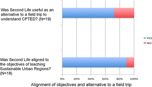
The aim of the unit is to teach students from backgrounds in environmental science, management and planning about strategic planning from a sustainability perspective. Students are asked to consider a variety of case studies of sustainable planning. One aspect of sustainability that is covered is urban accessibility and social inclusion. It was decided as part of the learning and teaching project using Second Life to ask students to use Crime Prevention Through Environmental Design (CPTED) as a lens through which to view accessibility in the city. CPTED is a well-known group of guidelines for designing spaces to minimise the fear of crime (CitationSchneider and Kitchen, 2002). While guaranteeing that spaces are crime free can be all but impossible, it is possible to create spaces that give people a sense of security so they are not deterred from accessing them. As such, CPTED can be one of a number of useful tools for planners to use when designing an area from a sustainability point of view.
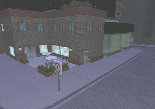
Second Life was chosen to run a simulation (). Second Life was chosen over other simulations such as a 3D GIS because it allows users to guide an avatar which, we would argue, allows students to empathise with the avatar in the simulated environment, provoking them to think more about the design of spaces. More generally, a simulated field trip was chosen for this workshop because it would be unethical to evaluate students' fear of crime during a trip at night ().
Figure 1 A dystopian street environment for teaching about CPTED in Second Life
In order to prepare students for the exercise, an introductory lecture was given the week before, to describe why Second Life is interesting from a planning point of view. The lecture was inspired, among sources, by Elizabeth Townsend-Gard of Tulane University's law school. In her exercise, first year students were asked to participate in a deliberately ‘naive’ exercise that looked into certain fundamental tenets of property law and investigated whether these had translated into the virtual world (CitationTownsend Gard and Goda, 2008). Second Life was used in a similar way to trigger student discussions on the nature of planning. The recent history of planning in Second Life was used to demonstrate how the concept of property is shaped by events, circumstances and non-material values. While the introductory lecture focused on property, students were asked to consider different ways in which Second Life could apply to planning. Overall, the lecture was designed to introduce students to Second Life as more than a 3D visualisation medium.
Using Second Life for Teaching Crime Prevention through Environmental Design
The next part of this paper describes a workshop that was designed to give the students an opportunity to explore an area that would normally be out of reach, or difficult to access, in a classroom. For this workshop we drew on the street auditing toolkit designed by CitationAzmin-Fouladi (2008), the productive possibilities of the virtual world as described by CitationBayne (2008) and the work of Graham Steventon (see CitationSteventon et al., 2008).
Using an island in Second Life, a space was designed for post-graduate planning students as part of the unit. The exercise was designed with the assumption that students had not previously encountered Second Life and or had little prior understanding of 3D visualisation.
The 19 students in the unit were all present in the room at the same time as the exercise was undertaken. Second Life was used to convey the subtleties of Crime Prevention Through Environmental Design (CPTED). Students were asked to read and reflect upon material about CPTED (e.g. CitationCozens et al., 2005). They were then asked to explore and deconstruct a dystopian environment that was designed to display elements of CPTED during a three hour class. The elements focused on were territoriality, surveillance (passive, active and mechanical), activity support, access control, target hardening and image management (see CitationCozens et al., 2005).
Students were referred to particular parts of the built environment and asked to record their feelings about how the design would promote or suggest fear of crime. At the end of the session the class discussed the sites. In order to gather the students' perspectives about their reactions to Second Life and the exercise, a survey was used. They were asked to rate the exercise in terms of how it helped their understanding of CPTED, whether definitions used in CPTED are contested and problematic and should other lectures be encouraged to use Second Life. Focus groups were also conducted to capture discussion on their views about the effectiveness of using Second Life and to explore in more detail the issues emerging in the survey.
Results and discussion
A total of 19 students participated in the study, completing the survey and then contributing to the focus group. Overall, their reactions were largely positive towards Second Life ().
Figure 2a The pre-workshop material about Second Life made me think about the role of technology in creating places and community
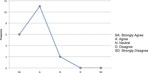
Figure 2b The workshop's use of Second Life helped me to understand what CPTED means in general
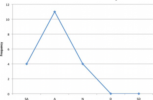
Figure 2c The use of Second Life illustrated aspects of CPTED to me (e.g. territoriality)
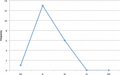
Figure 2d The use of Second Life helped me to understand that the definitions used in CPTED are not straightforward
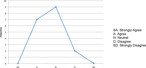
Figure 2e I would encourage other lecturers to use resources such as Second Life
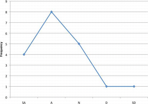
Figure 2 Student reactions to Second Life in the class ‘Sustainable Urban Regions’
Most survey respondents agreed or strongly agreed that the Second Life exercise was effective as an aid to understanding of concepts important for CPTED, such as dystopia (). This positive response was reiterated in subsequent discussions as part of the focus group, where students reported that the graphics available in the Second Life scenario helped them engage with the issues. Students generally were able to analyse successfully the dystopian environment. Their sense of bewilderment and feeling lost in the streetscape, normally a disadvantage when using a virtual world, helped them to empathise with the fear of crime. They appreciated the trouble that had been taken to design the exercise especially for this and felt that they would remember key aspects of crime prevention through environmental design because of their use of the virtual world. Of course there was no follow up to test this, but it is possible to imagine that the novelty of the experience and the technology would add to it being a memorable classroom experience.
Two students however, commented that real field trips were more useful. Another found problems with the technology and suggested giving more time to learn to walk and move around inworld. Two more students were put off with the technology, citing it as being too clunky. In the follow up focus group, it emerged that these comments came from students who already had extensive experience of computers through their work and used 3D visualisation and GIS extensively. For these students the visualisation in Second Life was seen to be quite primitive compared to the tools they used at work. This divergence in student options from a sense of being overwhelmed by the challenge of using the technology to finding it inferior to what they usually use, is a theme that emerges from the literature (CitationBennet et al., 2008; CitationKennedy et al., 2008) and is an important one to consider for educators who wish to use Second Life, or another virtual world. In planning and the built environment, students may already have access or experience with games or other 3D visualisation technologies and may regard the technology as beneath their ability. In the same cohort, there may be students with very limited experience and confidence in using technologies in their learning. Overt measures to help manage student expectations may be one means for reducing this barrier to student engagement. For example, clearly articulating the links between the learning outcomes intended in the unit and how the virtual environment experiences will contribute to the attainment of these outcomes, may help encourage students to see beyond the perceived limitations of the tools themselves. Similarly, the option of additional support, such as peer instruction in groups or online demonstration videos, may help encourage greater confidence in those students with limited experience with technologies.
The pilot could be refined in future through better training and the development of similar exercises. Building on the theme of allowing students to gain an understanding of issues that would normally be difficult to broach in class, the material developed could be adapted to help students understand mobility and accessibility in cities for the disabled, visually impaired and for children. An extension of the current method would be to ask students how these exercises informed their perception of the real world. However, it is clear that Second Life is suited to teaching of small scale design issues. Other components of the unit that require students to gain an understanding of larger scale strategic and regional planning issues would be difficult to teach using Second Life.
Conclusions
Since planning is concerned with land, buildings and their impacts, 3D visualisation is already widely understood to provide virtual studio space in planning courses. The objective of this paper was to look beyond these studies and understand how the existence of a virtual world can change teaching practice using 3D visualisation. While generalisability was not the primary aim of the case study, themes emerged that can be applicable to a wide range of curriculum contexts.
The research presented here is a pilot of an attempt to deal with a rapidly moving technology in an area that would appear on first approach to have an application in planning. However, as we have outlined above, such experiments should be undertaken with caution. Our approach was to select an application of a virtual world that resonated with an apparent demand: in this case the need to simulate a field trip in a classroom.
We would argue that Second Life can provide students with an experiential option of exploring a world that would be unavailable to them. Considering their role as professionals within the built environment, this would be particularly useful in helping them to understand the ‘other’ both as a space and a subject. As in other studies (Citationde Freitas, 2006) technology can become a barrier to learning as students grapple to learn to navigate and move around inworld. In order to overcome these challenges and integrate technologies such as Second Life into the curriculum, time and support need to be provided for students as they learn about this new world and how the virtual experience can be relevant in their practice.
We return to CitationFrank's (2006) review of planning education; in this she points out other approaches to planning education. These include problem-based learning, experiential learning and other field-based work. We would argue that a virtual world such as Second Life should be firstly introduced deliberately as a heuristic tool that provokes students to think about the real world. This would avoid the criticism that the skills being learnt to move in and manipulate the 3D word are inferior or irrelevant to 3D visualisation software. Instead, an engagement with virtual worlds can be used as a prelude to a field trip. The affordance of a virtual world, we would argue, lies in the ability to cross a boundary between what is virtual and what is real. Rather than seeking to immerse students in an alternate reality, the virtual world should be used to remove them out of their reality enough to reflect back on reality in the first place. In each of these cases the ability to cross the boundary between a virtual world should be used to explore and reflect on what is unusual about the real world, in the same way that visiting a foreign country can provoke students to think differently about what they are most familiar with.
This paper provides an example of how a given technology, such as 3D visualisation, is appended to or bolted on to a technologically rich component of a curriculum. The socially relevant aspects of Second Life and virtual worlds more generally provide an opportunity to transcend this process, which we anticipate will continue with technological progress. As software tools that employ virtual world technology with relevance to planning become more prevalent in class and practice, reflection and debate on the possibilities of these tools will continue. Tools such as Google's Sketchup allow design, 3D viewing and seamless integration into Google maps for example. As such tools become more sophisticated and migrate to smartphones and other devices, the sociological and geographical imagination of students will change (cf. CitationHarvey, 1970) and with it the possibilities of using these tools in teaching practice.
Related Research Data
References
- Au W. J. (2008). The Linden billboards regulations seem to be working, but are they enough to make the SL land appealing? URL: http://nwn.blogs.com/nwn/2008/10/as-advertised-f.html
- Azmin-Fouladi N. (2008). Accessibility and user needs in transport. In: Thwaites K., Porta S. & Romice O. (Eds.). Urban sustainability through environmental design. London: Routledge.
- Bayne S. (2008). Uncanny spaces for higher education: Teaching and learning in virtual worlds. ALT-J, 16 (3), 197–205.
- Bennett S., Maton K. & Kervin L. (2008). The ‘digital natives’ debate: A critical review of the evidence. British Journal of Educational Technology, 39 (5), 775–786.
- Biggs J. & Tang C. (2007). Teaching for quality learning at university. 3rd ed. Maidenhead: Open University Press.
- Bishop I. D. (2000). Environmental information and technology: Is it all too much? Landscape and Urban Planning, 47 (3–4), 111–114.
- Boellsdorff T. (2008). Coming of age in Second Life. Princeton: Princeton University Press.
- Butler D. (2008). Air Gondwana: Teaching basic negotiation skills using multimedia. Journal of the Australasian Law Teachers Association. Individual papers. 1-14 URL: http://www.alta.edu.au/JALTA%20Individual%20Papers.htm
- Cozens P. M., Saville G. & Hillier D. (2005). Crime prevention through environmental design (CPTED): A review and modern bibliography. Property Management, 23 (5), 328–356.
- Creswell J. & Plano Clark V. (2007). Designing and conducting mixed methods research. Thousand Oaks: Sage.
- de Freitas S. (2006). Using games and simulations for supporting learning. Learning, Media and Technology, 31 (4), 343–358.
- de Freitas S. & Neumann T. (2009). The use of ‘exploratory learning’ for supporting immersive learning in virtual environments. Computers & Education, 52 (2), 343–352.
- Foth M., Bajracharya B., Brown R. & Hearn G. (2009). The Second Life of urban planning? Using NeoGeography tools for community engagement. Journal of Location Based Services, 3 (2), 97–117.
- Frank A. I. (2006). Three decades of thought on planning education. Journal of Planning Literature, 21 (1), 15–67.
- Gibbs D. & Gosper M. (2006). The upside-down-world of e-learning. Journal of Learning Design, 1 (2), 46–54.
- Gonzalez A., Gilmer A., Foley R., Sweeney J. & Fry J. (2008). Technology-aided participative methods in environmental assessment: An international perspective. Computer, Environment and Urban Systems, 32 (4), 303–316.
- Gordon E. & Koo G. (2008). Placeworlds: Using virtual worlds to foster civic engagement. Space and Culture, 11 (3), 204–221.
- Gosper M., Woo K., Muir H., Dudley C. & Nakazawa K. (2007). Selecting ICT based solutions for quality learning and sustainable practice. Australasian Journal of Educational Technology, 23 (2), 227–247.
- Harvey D. (1970). Social process and spatial form: An analysis of the conceptual problems of urban planning. Papers in Regional Science, 25 (1), 47–69
- Hollander J. B. & Thomas D. (2009). Commentary: Virtual planning: Second Life and the online studio. Journal of Planning Education and Research, 29 (1), 108–113.
- Horne M. & Thompson E. M. (2008). The role of virtual reality in built environment education. Journal for Education in the Built Environment, 3 (1), 5–24.
- Ishii H., Underkoffler J., Chak D., Piper B., Ben-Joseph E., Yeung L. & Kanji Z. (2002). Augmented urban planning workbench: Overlaying drawings, physical models and digital simulation. Proceedings of the International Symposium on Mixed and Augmented Reality (ISMAR'02) Darmstadt, Germany, Sept. 30–October 1, 2002.
- Johnson T. & Huang W. (2008). Complex skill development for today's workforce. In: Ifenthaler D., Pirnay-Dummer P., Spector J. M. & Pirnay-Dummer P. (Eds.). Understanding models for learning and instruction. New York: Springer.
- Kennedy G., Judd T., Churchward A., Gray K. & Krause K. (2008). First year students' experiences with technology: Are they really digital natives? Australasian Journal of Educational Technology, 24 (1), 108–122.
- Kingston R., Carver S. & Turon I. (2000). Web-based public participation Geographical Information Systems: An aid to local environmental decision making. Computers, Environment and Urban Systems, 24 (2), 109–125.
- Koll-Schretzenmayr M., Keiner M. & Nussbaumer G. (2004). Editors' introduction. In: Koll-Schretzenmayr M., Keiner M. & Nussbaumer G. (Eds.). The real and virtual worlds of spatial planning. New York: Springer.
- Krygier J. (1999). Public participation visualization: Conceptual and applied research issues. URL: http://krygier.owu.edu/krygier_html/lws/lws_context.html.
- Lange E. (1994). Integration of computerized visual simulation and visual assessment in environmental planning. Landscape and Urban Planning, 30 (1–2), 99–112.
- Linden J. (2008) Second Life and Ad farms. URL: http://lindenlab.wordpress.com/2008/09/04/second-life-and-ad-farms/
- Minocha S. & Reeves A. J. (2010). Design of learning spaces in 3D virtual worlds: An empirical investigation of Second Life. Learning, Media and Technology, 35 (2), 111–137.
- New Media Consortium. (2007). The Horizon report. New Media Consortium and Educause Learning Initiative. URL: http://www.nmc.org/pdf/2007_Horizon_Report.pdf. (Accessed 2 February, 2008).
- O'Looney J. (2000). Beyond maps, GIS and decision-making in local government. Redlands, CA: ESRI.
- Pappa D., Dunwell I., Protopsaltis A., Pannese, Hetzner S., de Freitas S. & Rebolledo-Mendez G. (2010). Game-based learning for knowledge sharing and transfer: The e-VITA approach for intergenerational learning. In: Felicia P. (Ed.). Handbook of research on improving learning and motivation through educational games: Multidisciplinary approaches. Hershey: IGI Global.
- Peters A. (2008). The changing role of GIS and US planning education. In: Thompson S., Gurran N., Phibbs P. & Searle G. ANZAPS Proceedings Planning Education in a Globalised World, University of Sydney 26–28 September 2008.
- Phillips R., McNaught C. & Kennedy G. (2012). Evaluating e-learning: Guiding research and practice. New York: Routledge.
- Prensky M. (2001). Digital natives, digital immigrants. On the Horizon, 9 (5).
- Schneider R. H. & Kitchen T. (2002). Planning for crime prevention: A transatlantic perspective. London: Routledge.
- Steins C. (2007). A parallel universe: What the virtual world can do for planning. URL: http://www.urbaninsight.com/articles/2ndlife0307.html
- Steventon G., Grove P. & Childs M. (2008). Shared spaces in a ‘safe’ urban jungle: Juggling pedagogical goals and student needs and expectations. Proceedings ofAscilite 2008 Conference, Melbourne. 30 Nov–3 Dec 2008.
- Townsend Gard E. & Goda R. (2008). The fizzy experiment: Second Life, virtual property and a 1L property course. Santa Clara Computer and High Technology Journal, 24. URL: http://ssrn.com/abstract=1148280
- Wissen U., Schroth O., Lange E. & Schmid W. (2008). Approaches to integrating indicators into 3D landscape visualisations and their benefits for participative planning situations. Journal of Environmental Management, 89 (3), 184–196.
- Yin L. (2010). Integrating 3D visualization and GIS in planning education. Journal of Geography in Higher Education, 34 (3), 419–438.