
In 1963 the first British Cartographic Society Council selected an editorial committee, appointed J. S. Keates as Editor, and in November of that year bestowed the title ‘The Cartographic Journal’ to a new publication. The first issue was published in June 1964 and carried a foreword by the new Society’s Chairman, Brigadier D. E. O. Thackwell, who announced The Journal’s intention ‘to give news of all general cartographic activities, to include reports of symposia, meetings, and of their discussions, to publish articles of cartographic interest, and to review maps, atlases and books on cartography’. The past 50 years has seen hundreds of articles on all aspects of cartography published as The Journal continues to set the standard in its field. The diverse nature of cartography has been well represented throughout The Journal’s history with articles on every aspect of the subject. Far more than providing a barometer of change in cartography, together they offer a fascinating insight into the influence of maps and mapping on society and the evolution and impact of technology, particularly with respect to digital media, dynamic mapping and the upsurge in GIS.
The Journal contains numerous papers that explore specific areas of work such as computational approaches to new map projections, alternative generalization algorithms and mapping for users with specific needs, as well as papers that explore customized content, international map products and the changing landscapes of commercial and academic cartography. The broad scope of work published remains a key feature of The Journal in both its refereed and non-refereed sections that encourage high-quality academic research and general interest papers. Many eminent cartographers and cartographic scholars have chosen The Cartographic Journal as a vehicle for disseminating their work, establishing the publication’s distinguished reputation and contributing to the development of many careers as well as to cartography as a discipline.
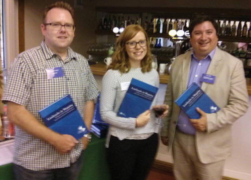
Over the course of the last year or so, Assistant Editor Alex Kent and I have been working hard to bring to bear a book celebrating the 50th Anniversary of The Cartographic Journal. We’re delighted to announce that the book, entitled Landmarks in Mapping, launched at the British Cartographic Society Annual Symposium in June. Published by Maney, the book is a celebration of the very best articles that have appeared in The Journal during its first 50 years and Alex and I were joined by Maney’s Managing Editor Laura Bradford at a special reception to celebrate the launch ().
Figure 1. Journal Editor Kenneth Field, Maney Managing Editor Laura Bradford and Journal Assistant Editor Alex Kent celebrate the launch of Landmarks in Mapping at a special reception
As the first general distribution journal of cartography to appear in English we felt it was important to mark the first 50 years with a landmark. In fact, this eventually became the title of the book which seemed appropriate both to mark the anniversary but also as a description of the papers contained within. The process of selecting the papers for inclusion was no easy task and involved countless iterations and discussions among the 30 or so members of our distinguished Editorial Board. Needless to say, everyone has their own favourite papers, perhaps that align with a certain interest and inevitably there was no best method to compile a collection that matched all tastes. We hope we’ve captured something of the flavour of The Journal’s contribution to cartographic research and thinking and initial reviews have been extremely positive. We’ve brought together papers that won the annual ‘best paper’ award, some classics that perhaps began rather more modestly and those papers that remain core to cartographic discourse. The intent was very much to provide a compendium that brings together classic and contemporary papers that reflect The Journal in a single, accessible issue. But a collection of re-printed papers doesn’t suffice so each reprinted paper is accompanied by an invited reflection article authored by one of the Editorial Board members. These original papers present the original work in a context, discuss a little of their value to cartographic discourse and share interesting stories. The book, then, provides a window into the very best work published in The Journal alongside original pieces to create a genuine landmark of the first 50 years of publication.
This issue of The Journal brings a further 8 papers to add to the collective works. First, Claudia Knust and Manfred F. Buchroithner explore the way in which the term ‘3D’ has become synonymous with a wide variety of cartographic output and used to broadly explain a range of different techniques. They bring much of this reasearch together to provide a timely point of reflection and help frame what 3D actually means for cartography. Jan D. Bláha and Zbyněk Štěrba present an interesting discussion of how Swiss expressionist painter Johannes Itten’s principles of colour might have a practical value to cartography. In so doing, they extend the palette (pun intended!) that we might use beyond the traditional colour models more formally associated with cartographic practice. I never thought I’d be introducing an article on cartographic vandalism yet Andrea Ballatore introduces us to an emerging issue relating particularly to the generation and curation of online volunteered geographic information. This data is at the mercy of intentional defacement which could very easily propagate unwittingly into other map products. The way in which this issue may be recognised, seen and addressed is the focus of Ballatore’s paper. Most cartographers will agree that a beautiful hill-shading adds value to a map, albeit perhaps in an aesthetic way that is difficult to quantify. But what of the impact of different techniques for relief representation on map use? Do they add to the map or, perhaps, in some way detract from map reading tasks. Katja Putto et al. present the findings of their study into how different relief representations affect visual search, area selection and route navigation tasks. Attention turns to historical cartography with Elri Liebenberg’s fine analysis of the struggle to survey South Africa in the early-mid 1900s and the eventual production of the first consistently surveyed topographic map at 1:500,000. Alexander Nossum tackles the widely known issues of usability of Hägerstrand’s space-time cube by employing a novel approach using eye tracking analysis. He takes two-dimensional projections of the space-time cube and then demonstrates how visualising through an XT and YT plane can improve identification of patterns in the data often obscured in the three-dimensional original. Finally, we include a two-part paper by Brian Robson who explores the life and works of the little known 19th century cartographer John Wood. Robson makes a case for a wider recognition of Wood’s contribution to British cartography by uncovering more of his work than was previously known.
While we celebrate past papers through the new book, this issue of The Journal adds to the canon with a range of diverse and fascinating papers in their own right…some of which may very well be considered for the second volume of Landmarks in Mapping slated for sometime around 2064. We look forward to the next 50 years and wonder on the fantastic changes that will shape cartography in the coming years.
Kenneth Field
July 2014
Redlands, CA
BIOGRAPHICAL NOTES
Dr Kenneth Field works in Cartographic Research and Development at Esri Inc and was formerly Principal Lecturer and GIS Course Director at Kingston University London. He holds a PhD in GIS from Leicester University and has presented and published widely on map design. He is a Fellow of the British Cartographic Society, Royal Geographic Society and a Chartered Geographer (GIS). He is also Chair of the ICA Commission on Map Design (mapdesign.icaci.org), maintains a personal blog (cartonerd.com) and tweets (@kennethfield). Don’t forget you can follow The Cartographic Journal on Twitter (@CartoJnl).