Abstract
The site of Tuzusai is located in the Tien Shan Mountains of eastern Kazakhstan; occupation at the site between 410 B.C. and a.d. 150 represents the transition between the Saka and Wusun periods (Saka: 800–200 b.c.; Wusun: 200 b.c.–a.d. 400). Iron Age people of Central Asia are often described simply as mobile pastoralists, yet at Tuzusai, we have evidence that agriculture was practiced along with pastoral transhumance. This multiresource economic system combined pastoralism and hunting with the cultivation of a variety of crops. Our new finding is significant because Tuzusai has the first clear evidence for the presence of agriculture from the Iron Age of northern Central Asia. The diversity of crops grown at Tuzusai required varying labor and time inputs and a well-planned scheduling system.
Introduction
Macrobotanical analyses of flotation samples from the Iron Age site of Tuzusai, located in the Central Asian mountain-steppe zone at the southern border of the Eurasian steppe (), show that Iron Age people cultivated crops in addition to maintaining herds. It has long been argued that the Iron Age (ca. 800 b.c.–a.d. 400) in Central Asia was a seminal period for the development of nomadic loosely allied mobile states, such as the Saka, Wusun, and Yuezhi (Anthony Citation2007; Kohl Citation2007; Koryakova and Epimakhov Citation2007). It was during this time period that most researchers discern a shift from a mixed economy toward a more mobile pastoral economy (Abetekov and Yusupov Citation1999; Ishjamts Citation1999; Koryakova and Epimakhov Citation2007). Archaeological evidence shows an increase in settlement and burial mound size, demographic shifts, and increased exchange (Kuz’mina Citation2007, Citation2008). The greater spread of material culture identified in the archaeological and historical records beginning in the Iron Age, especially in eastern Central Asia, has been attributed to exchange networks referred to as the Silk Road. Exchange through the mountainous regions of Central Asia can be traced back to the Early Bronze Age (ca. 3500–2000 b.c.) (Frachetti Citation2012; Li Citation2002; Linduff Citation2006), but systematic movement of goods through these mountains did not occur before the founding of the Han Dynasty (206 b.c.–a.d. 220). The early Iron Age is a pivotal point in the development of the Central Asian economy, and Koryakova and Epimakov (2007: 338) refer to this period as “the most dramatic moment in the prehistory of Eurasia.” Here we describe Iron Age agricultural production alongside pastoralism in the Talgar region of southeastern Kazakhstan. This contrasts with the long-held “nomadic” model of Iron Age pastoral mobility. We present the results of a new macrobotanical study conducted at Tuzusai based on flotation samples collected and analyzed by the first author (RS) over a period of three consecutive field seasons.
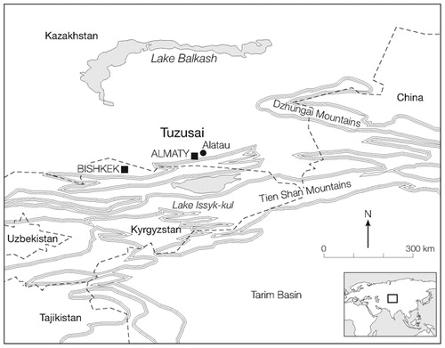
Figure 1. Map of eastern Central Asia with the Tuzusai site indicated.
Background
Tuzusai is located in the Semirech’ye region of Kazakhstan, about 15 km east of Almaty (). The site is situated 6 km north of the Tien Shan foothill zone at 723 masl. Tuzusai is located on a rich alluvial fan, which today supports irrigated agriculture. Agricultural risk due to irregular rainfall is mitigated through the use of artificial watering systems, which involves rechanneling of mountain streams (Utesheva Citation1959). Excavations at Tuzusai, Taldy Bulak 2, and Tseganka 8, all located on the Talgar alluvial fan, were conducted by Chang and colleagues (2002) as part of the Kazakh-American Talgar Archaeological Project (Chang et al. Citation2003; Rosen et al. Citation2000). These settlements were occupied during the Iron Age by people in the Saka (800–200 b.c.) and Wusun (200 b.c.–a.d. 400) confederacies. Zooarchaeological evidence demonstrates that pastoralism was a major component in the economy. The faunal assemblage is dominated by sheep and goats, typical of most highly mobile Central Asian peoples (Frachetti and Benecke Citation2009). Sheep and goats can graze on agricultural stubble and fallow while manuring fields, thus articulating well with cereal cultivation (Koster Citation1977). Cattle were also abundant; as Bendrey (Citation2011) notes, cattle are effectively pastured in riparian environments or in alpine meadows. In addition, horses, donkeys, camels, and dogs were present in small percentages, indicating that inhabitants of the region maintained a variety of domesticated animals. The presence of wild species, albeit in low frequencies, suggests that hunting was practiced and included roe and red deer, wild pigs, and foxes (Chang et al. Citation2003).
In addition to pastoralism at Tuzusai and other Iron Age settlements of Talgar, the remains of domesticated cereals indicate that farming was another important component of the economy (Chang et al. Citation2002). Palaeoethnobotanical analyses conducted in the late 1990s and early 2000s found evidence for an agricultural system on the Talgar fan and is supported by the results of the new macrobotanical study presented here. Phytolith analysis (Rosen et al. Citation2000) and a preliminary macrobotanical study (N. Miller, personal communication 2011) conducted at Tuzusai, Taldy Bulak 2, and Tseganka 8 suggest a complex agricultural system. Based on comparison with 18th- and 19th-century Kazakh households that practiced both farming and herding, Chang and colleagues (2002) suggest that some of the Tuzusai villagers remained at the site year-round to maintain crops, while other household members moved their herds in the summer months to the foothills and upland valleys (about 20 km to the south). Benecke’s analysis of faunal remains from Tuzusai (Chang et al. Citation2003: 306) supports the notion of year-round occupation, based upon his estimates of the full range of age cohorts for sheep and goat remains.
At Tuzusai, excavations uncovered extensive mudbrick architecture, semisubterranean pit houses, and a central rectangular house with a sequence of replastered floors spanning a 300-year period. In addition, over 55 settlements and 225 Iron Age burial mounds were recorded during surveys conducted in the mid-1990s across the Talgar fan (180 sq km) (Chang Citation2006). These survey data point to a relatively high population density on the Talgar alluvial fan during the Iron Age (Chang et al. Citation2002). We propose that agriculture, in tandem with mobile pastoralism, may have been responsible for population increases and the rise of social complexity in eastern Central Asia.
Here, we report the results of the analysis of 25 flotation samples from Tuzusai that confirm the importance of agriculture. Seeds are abundant in these samples compared with those at earlier agricultural village sites in southern Central Asia, such as the Middle Bronze Age sites of Sarazm and Shortughai (Willcox Citation1991), and the earlier Neolithic village of Anau, Turkmenistan (Miller Citation2003). Furthermore, cultivation of crops such as wheat and barley at Tuzusai required labor input that would not have been possible for mobile pastoralists. Harvesting and winnowing these crops was also time consuming, and probably took place annually using pooled labor.
Excavations at Tuzusai
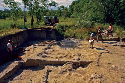
The Iron Age occupation at Tuzusai dates between 410 b.c. and a.d. 150 and is culturally represented by the Saka and Wusun. The site is located on the western bank of an old stream bed about 0·5 km north of the town of Alatau () and, based on the extent of the sherd scatter, covers an area of 5–13 ha. A small portion of the total area of the site has been excavated (most of the site is inaccessible due to active agricultural fields), where in 1992 and 1993 two large blocks were opened by a local archaeological team (totaling 20 × 6 m). In 1994–1996, the Kazakh-American Talgar Project excavated three contiguous 6 × 6 m units (Chang et al. Citation2002). The 2008–2010 excavations (a 20 × 5 m area) uncovered eight pit houses, a series of storage pits, and possible hearths (). There are at least six different cultural layers. The upper two cultural layers contain historical material dating from the Mongol period (ca. a.d. 1200) to the early 1900s and the lower stratigraphic layers are Iron Age. The site has been excavated to a depth of 1·6 m below the surface. The flotation samples, collected by RS during the 2008–2010 seasons, were taken from archaeological features at Tuzusai dating from ca. 410 to 150 b.c.
Figure 2. Photograph of the 2009 and 2010 excavation units.
The quantity of mudbrick architecture in the upper Iron Age occupation layers is important, as it indicates a major labor investment in the construction of houses and wall features. Numerous overlapping storage pits and larger semisubterranean pit houses are also present. AMS dates indicate that half a meter of sediment accumulation represents less than 300 years of occupation. This sediment is the result of accretional building and remodeling of mudbrick architecture. The thick accumulation of mudbrick and associated building debris overlying the semisubterranean pit houses found in lower occupation layers are comparable to the site formation processes described for tell sites farther south in Central Asia (Rosen Citation1986: 9– 25).
Previous botanical studies include a macrobotanical analysis done in 1996 (N. Miller, University of Pennsylvania Museum) that identified probable bread wheat (Triticum aestivum s.l., a hexaploid), barley (Hordeum vulgare) (differentiation between six- or two-row forms was not possible), millet (differentiation between broomcorn and foxtail was not possible), a few grape seed fragments (Vitis vinifera), nut shell (probably almond [Prunus sp.]), and a possible hawthorn seed (Crataegus sp.) (N. Miller, personal communication 2011).
A more thorough analysis was conducted on phytoliths extracted from samples excavated at Tuzusai and Tseganka 8 during the 2002 and 2003 field seasons (A. Rosen, personal communication 2011). Tseganka 8 has Iron Age layers contemporary with those at Tuzusai and is only a few kilometers away. At Tseganka 8, Rosen and colleagues found barley and panicoid grass phytoliths that they call “millet (Setaria sp.)” (foxtail millet [Setaria italica] in Chang et al. [2002]). At Tuzusai, Rosen and colleagues identified phytoliths of millet and rice (Oryza sativa). These microbotanical studies indicate that there was a multicropped agricultural system in use during the 1st millennium b.c. (Rosen et al. Citation2000).
Environmental Setting
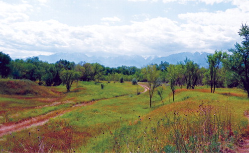
The Talgar alluvial fan is situated in the mountain/steppe interface ecotone (). Rosen and colleagues (2000: 611) characterize the region as “a richly diverse mosaic of landscapes within a relatively restricted area,” in which mountain streams fed by precipitation and glacial melt cut deep fluvial channels into the alluvium. These stream banks are covered with thick riparian vegetation. The edges of the mountains are flanked by a foothill zone composed of uplifted bedrock with loess and eroded alluvium deposits. Vegetation communities of the foothills are distinct from the shrubby-forest/steppe vegetation or riparian vegetation of the fan itself. Instead, the foothills contain a patchwork of microenvironmental zones (ecotopes), including riparian areas, grass-dominant fields, mixed-forb (herbaceous flowering plants)/grass fields, and conifer and deciduous forests.
Figure 3. View looking south from the site toward the Tien Shan Mountains.
Specific arid-land grass species include Bothriochloa ischaemum, Festuca valesiaca, Kochia prostrata, Stipa capillata, S. caucasica, and S. sareptana. The riparian areas are dominated by Populus tremula and willows (Salix spp.). The composition of the shrubby forests has been drastically altered by modern agricultural practices so that today the dominant species include feral apricots (Prunus armeniaca) and cherry (P. avium) (presumably planted during the Soviet period). The conversion of this forest ecotone into fields may extend as far back as the Iron Age. Prior to human modification of the landscape it is likely that the shrubby forests were dominated by Elaeagnus (E. angustifolia and E. oxycarpa: Russian olive), Hippophae rhamnoides (sea buckthorn), Rosa spp. (wild rose), Viburnum opulus (common viburnum), Rubus spp., and several species of wild cherry (Cerasus spp. and Prunus spp.) and hawthorn (Crataegus spp.) (Dzhangaliev et al. Citation2003).
There is a high diversity of forbs in this zone; however, much of the species composition has been altered by agriculture and invasive plants. An invasive “weed” assemblage, typical in the northern hemisphere, includes species such as Cichorium intybus, Rumex crispus, and Taraxicum officiale. However, a number of other forbs are native including Achillea millefolium, Dipsacus dipsacoides, Hypericum perforatum, Lavartera thuringiaca, Nepata pannonica, Rumex tianschanicus, Salvia deserta, and Silene venosa (Evashenko Citation2008).
Chronology
The material discussed here dates between 410 and 150 b.c. The household architecture for these phases consists of semisubterranean pit houses with plastered or packed earthen floors. Flotation samples were taken from hearth features, floors, and 11 storage pits. Chang and colleagues (2003) established a detailed chronology for Tuzusai and Tseganka 8. These two sites show continuous occupation throughout the Iron Age and successive abandonment episodes afterward (Chang et al. Citation2003). The chronology is based on 15 AMS dates from stratigraphic levels at the two sites, nine of which are from Tuzusai. Ten new AMS dates (; ) place the primary Iron Age occupation at the site during a 500-year period, from ca. 410 b.c. to a.d. 150.
Figure 4. Calibrated AMS dates for the Iron Age at Tuzusai.
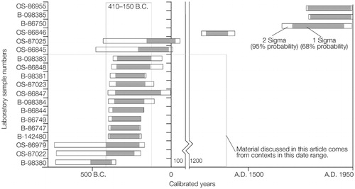
Table 1. AMS dates and phases from Tuzusai.
A historical occupation at the site (in the 1800s or early 1900s) is represented by two intrusive fire pits and dated by a Czar Nicholas II 20 kopek piece. Mongol period occupation (13th–15th centuries a.d.) is marked by a series of burials (Chang et al. Citation2003; Chang et al. Citation2002). The burial shafts penetrate Iron Age layers, but are discrete events distinguishable from the Iron Age fill. Two dates obtained from material excavated in 1996 (Chang et al. Citation2003) fall within what Chang and colleagues (2003) refer to as Stratum 5 or 6 in the chronological sequence; these dates are in the range of 150 b.c. to a.d. 100. They come from old excavation units in the western part of the site and correspond to a phase of occupation not represented in the 2008–2010 excavations. The remaining dates from 2002 (Chang et al. Citation2003) and our additional 10 AMS dates from layers where flotation samples were obtained cluster tightly around 410–150 b.c., with the possible exception of one older date ranging between 522–383 b.c. at 2σ. Still, the statistical range for this date places it well within the Phase V/IV occupation () (Chang et al. Citation2003). This earliest dated grain comes from the base of Pit house 7.
Table 2. List of flotation samples with densities (seeds per liter) and context: FS # represents the year the sample was collected (2008–2010) and the chronological/numerical sequence.
Methods
Samples were collected by RS from all significant contexts during the 2008–2010 field seasons and processed in the field using a SMAP machine (Fritz Citation2005: 780–784; Pearsall Citation2000: 29–33; Watson Citation1976: 79–80). The SMAP machine uses motorized agitation for washing sediments in order to separate carbonized seeds and plant materials from the soil matrix. The machine used at Tuzusai was built in the late 1990s and uses an overflow spout. Water is pumped into the agitation tank while organic material is caught in the overflow spout by a geological sieve with 0·355 mm mesh. The volume of each sample was measured to the nearest 0·5 L. Heavy fraction samples were collected inside the tank by a geological sieve with 1·4 mm mesh. Both the heavy and light fractions were dried before sorting.
The heavy and light fraction samples were sorted using geological sieves at the Palaeoethnobotany Laboratory at Washington University in St. Louis. Botanical material larger than 2·00 mm was sorted as one sample unit, while smaller material was subdivided into separate units on the basis of mesh sizes of 1·50 mm, 1·00 mm, 0·71 mm, 0·50 mm, and 0·355 mm. Organic material smaller than 0·355 mm was visually scanned, but not systematically analyzed.
Both carbonized and uncarbonized seeds were systematically identified from each sample unit. It was assumed that uncarbonized seeds came from undisturbed contexts and were not intrusive. Uncarbonized seeds were kept separately from carbonized seeds and are not presented in this article because it is unclear whether they are modern or ancient. Yet, Popova reported large numbers of uncarbonized Chenopodium and Amaranthus seeds at the site of Krasosomarskoe, located in the lower Volga region in Samara, Russia, dating to the Late Bronze Age (Anthony et al. Citation2005; Popova Citation2006). Shishlina and colleagues (2008: 240–241) also reported preserved uncarbonized Amaranthus albus seeds at the site of Gashun-Sala in the Yergueni Hills (on the steppe northwest of the Caspian Sea) dating to the Late Bronze Age and early Iron Age.
Flotation Samples
The flotation samples from Tuzusai are designated by the year they were collected (2008, 2009, and 2010) and a sequence within that year (). All of the samples presented in this article are from the occupation period ranging from 410 to 150 b.c.
Archaeobotanical Assemblage
The flotation samples range in volume from 2 to 16 L; the total volume of floated soil is 212·5 L. The 25 samples yielded a total of 3163 carbonized seeds (excluding uncarbonized and unidentifiable seed fragments). Unidentifiable seed fragments comprise 1309 specimens. Of the total number of carbonized seeds, 2314 (73·1%) represent domesticated plants and 849 seeds (26·9%) represent wild plants. The total density of seeds per liter of sediment is 14·85; this figure can be divided into 10·02 domesticated grains per liter and 3·99 wild seeds per liter (see Appendix).
The macrobotanical assemblage from Tuzusai includes seven crop species: hulled barley (likely all six-rowed [Hordeum vulgare var. vulgare]), naked barley (H. vulgare var. nudum), free-threshing compact wheat and free-threshing lax-eared wheat (likely hexaploid [Triticum aestivum/turgidum]), broomcorn millet (Panicum miliaceum), foxtail millet (Setaria italica), and grape seeds (Vitis vinifera). The different varieties of wheat and barley are categorized as distinct crops because they may have been selectively bred as separate landraces, rather than representing a single highly variable variety or cross-breed of varieties. For example, because there are potentially different landraces of wheat present in this assemblage, we might assume that the ancient farmers grew these crops in separate fields and spaced them apart, either intentionally or unintentionally, to maintain the genetic integrity of a specific landrace.
The category “cerealia” is used to group fragmentary grains that cannot be distinguished as either wheat or barley specifically (n = 880 cerealia fragments). The category “millet” contains fragmentary broomcorn or foxtail millet grains (n = 157 millet fragments).
Free-threshing wheats
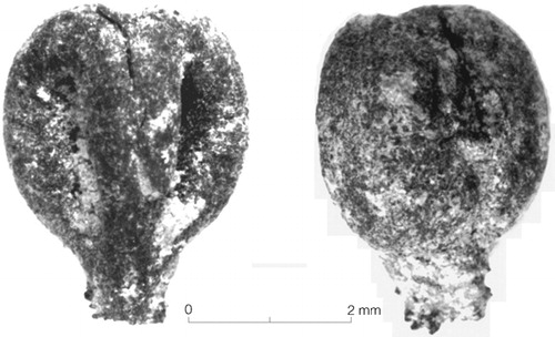
Free-threshing wheat (Triticum aestivum/turgidum) is the most abundant domesticated grain in the Tuzusai assemblage (). There is a high degree of morphological variability among these grains as well as very few rachises and spikelet parts. A single fragmentary rachis (09FS25) was identified as a hexaploid variety of wheat. Therefore, it is likely that all of the grains are from a free-threshing hexaploid wheat, although we cannot rule out the possibility that some represent a free-threshing tetraploid wheat.
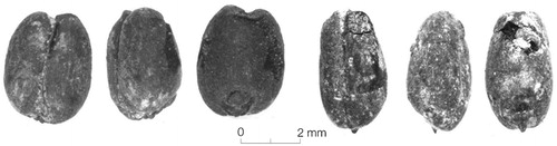
Figure 5. A free-threshing compact-eared wheat grain from 09FS11 (left) and a free-threshing lax-eared wheat grain from 09FS5 (right). Ventral, side, and dorsal views of each grain are shown.
The site of Shortughai in Turkmenistan, dating to ca. 2000 b.c., contains a diverse wheat assemblage similar to Tuzusai. Using length and width ratios, CitationWillcox identified two distinct varieties: compact-eared and lax-eared. Willcox (Citation1991) argues that these varieties were grown separately in different plots; however, he also notes that the range of variation in wheat morphology is characteristic of most landrace crops. Therefore, while it is problematic to identify varieties based on morphology alone, we argue that at both Shortughai and Tuzusai, there appear to be distinct landrace varieties of wheat. For both sites this might indicate the use of crop diversification in order to reduce agricultural risks due to drought and other climatic factors; certain landraces of wheat are more tolerant to environmental stresses than others.
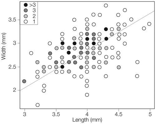
All wheats are grouped into a single category for quantification purposes; however, it appears that there are at least two varieties of wheat in the assemblage from Tuzusai, a compact-eared form and a lax-eared form (cf. Willcox Citation1991). The lax-eared form is elongated and narrow, while the compact form is short and wide. Researchers sometimes refer to these compact wheat varieties as T. compactum or T. aestivo-compactum. A 1·5 ratio of length to width is used as the arbitrary cut-off for lax-eared wheats to separate them from compact varieties (Renfrew Citation1973: 60–63). shows a cluster plot of individual measurements for 199 wheat grains from Tuzusai. The graphed line represents the division of a 1·5 length to width ratio between the two forms. Therefore, wheats falling above the line would be viewed as compact-eared, whereas those below would be lax-eared. However, since this graph actually shows a linear range of variation among the Tuzusai wheats with a lack of clear division between the two forms it is possible that there is simply a wide range of variation within a single variety of wheat, and lax- and compact-eared wheats were readily crossed and therefore are not distinct landraces.
Figure 6. Weighted cluster plot of length to width measurements from Tuzusai wheat grains (n = 199).
A total of 448 wheat grains and fragments were identified. The category of cerealia was used rather than using a Minimum Number of Individuals (MNI) estimates. A positive identification as to whether a grain was wheat or barley usually required that at least 50% of an individual grain was intact, therefore, the total count of either wheat or barley grains was the MNI. There is a density of 2·10 wheat grains per liter. Wheat ubiquity (percentage of samples containing a category) is 88%, the same ubiquity as barley and also the highest density of any grain at the site. Individual sample abundance ranged from 0 to 126 grains. Of the “whole” fully measurable wheats (n = 199) the average length was 3·94 mm and the average width was 2·85 mm.
Hulled and naked barley
The second most abundant grain identified in the assemblage was barley. Most of the barley appears to be hulled; however, some grains are of a naked form (). In many cases the naked barley grains are not clearly differentiated from the hulled form; therefore, they were not tallied separately. Very few naked barley grains were present at Tuzusai. A total of 313 barley grains were identified. The total density is 1·47 grains per liter, and the ubiquity is 88%. Individual sample abundance ranged from 0 to 75 grains.
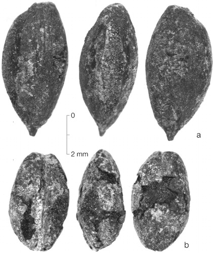
Figure 7. A) A hulled barley grain from 09FS6; B) A naked barley grain from 09FS1. Ventral, side, and dorsal views of each grain are shown.
A single barley rachis was found in 09FS9; however, it is too fragmentary to determine whether it came from a two-rowed or a six-rowed variety of barley. Many barley grains in the assemblage have a lopsided apex thus suggesting the presence of a six-rowed variety of barley. The difference in apex morphology was observed but not quantified.
Broomcorn millet
The third most abundant grain in the assemblage was broomcorn millet (). A total of 396 broomcorn millet grains have been recovered and identified. MNIs were not used. The category “millet” was assigned to most small fragments. At least 50% of the grain was required in order to differentiate between broomcorn and foxtail millet. Total density is 1·86 grains per liter, and total ubiquity is 80% for broomcorn. Individual sample abundance ranged from 0 to 68 grains.
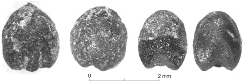
Figure 8. A foxtail millet grain (right) from 09FS25 and broomcorn millet grain (left) from 09FS6. Ventral (side) and dorsal views of each grain are shown.
Foxtail millet
Foxtail millet had the lowest abundance and ubiquity. There were 112 grains identified as foxtail millet. These were primarily differentiated from broomcorn millet by total size and the ratio of embryo notch (or scutellum) length to total seed length (). However, hilum (scar left on ventral surface from attachment to ovary wall) morphology was also loosely used as a factor in differentiating the two millets. Some morphological overlap does exist between broomcorn and foxtail millet grains. Total density of foxtail millet grains is 0·53, and the ubiquity is 64%. Individual sample abundance ranged from 0 to 23 grains.
Grapes
A few grape seeds were found at Tuzusai (). These are assumed to be cultivated and likely domesticated. N. Miller (personal communication 2011) identified fragments of grape pips at Tuzusai during the 1995 field season, and four more pips (MNI = 3) were found in samples 09FS5 and 10FS10. Morphologically the seeds of wild and early domesticated grapes are indistinguishable. Miller (Citation2008) summarizes the archaeological spread of viticulture from the Mediterranean eastward, and states that northern Central Asia lies outside the range of wild Vitis vinifera indicating that the pips probably came from domesticated grapes. These pips may represent exotic exchange goods or a locally grown horticultural product.
Figure 9. Image of a grape seed from 09FS5: ventral and dorsal views.
Discussion
Dung burning as fuel
Seeds (especially wild herbaceous seeds) found in macrobotanical assemblages may be the result of dung burning (Miller Citation1984, Citation1989, Citation1990, Citation1996; Miller and Gleason Citation1994; Miller and Smart Citation1984; Moore et al. Citation1994). In wood-scarce areas animal dung is a good fuel, both for cooking and heating. Dung often contains seeds that become incorporated into a palaeoethnobotanical assemblage when burned. There are clear environmental and economic parallels between Eurasian steppe sites and the Iranian Plateau arid-steppe sites where Miller has identified seed assemblages that are the result of dung fuel burning (Miller Citation1996). Not all the wild seeds in the assemblage are necessarily the result of dung burning (cf. Hastorf and Wright Citation1998: 222), although this could be a significant contributing factor that accounts for the abundance of wild seeds at Tuzusai.
All carbonized wood fragments (>2·00 mm) were systematically separated, and only two samples have wood weights greater than a gram—both of which are less than two grams and are each from dense hearth features. The relative lack of carbonized wood fragments in the Tuzusai samples is important, since both wood and dung are today used as fuel in Central Asia (often interchangeably), each having different heating purposes and properties. However, at Tuzusai wood does not seem to have been used regularly. By the Iron Age, the forests of the Talgar alluvial fan and foothills might have already been depleted. On the alluvial fan proper, wood fuel could have come from shrubby trees such as Russian olive (Eleaegnus), elm (Ulmus), or hawthorn (Crataegus), as well as riparian trees such as willow (Salix) and poplar (Populus). Usually wood resources in the steppe are more readily over-exploited than riparian wood sources (Hillman et al. Citation1997). This depletion of wood in the Talgar region during the Iron Age could suggest that environmental degradation took place as a result of increases in human population.
The carbonized wild herbaceous seeds identified at Tuzusai include several species of Poaceae and several of Fabaceae, as well as Chenopodium spp., Fragaria/Potentilla, Galium sp., Hyoscyamus niger, Lithospermum arvense, L. officiale, Malva (cf. sylvestris), Polygonum spp., Rosa sp., Tribulus terrestris, Vaccaria/Saponaria, and Xanthium sp. (see Appendix). All of these seeds come from plants found in the region today. Many of the genera identified are represented by species that grow directly on the site. Previous years’ excavation units were quickly colonized by Convolvulus arvensis, Onopordum acanthium, Cannabis sativa spp. ruderale, Chenopodium spp., Galium spp., and Polygonum spp. These species are typical of a grass and forb-dominant steppe. The macrobotanical data suggest that the general types of vegetation present today grew in the region over two millennia ago.
Agriculture and economy
Ethnohistorical examples of mobile pastoralists who incorporate small-scale, low-input agriculture into their economies can be found in the literature for Central Eurasia (Vainshtein Citation1980; Pashkevich Citation2003). In Central Asia proper, millets were traditionally associated with poor herders (Willcox Citation1991). Pastoralists sometimes planted small plots of drought-tolerant millets in river valleys or near naturally watered areas. These plots were often left completely unattended for most of the summer and little labor or time was required. However, such plots were usually sown with broomcorn or foxtail millet, in contrast to Iron Age Tuzusai where the most abundant grain was wheat.
The wheats, in contrast to the millets, require more labor, water, and nurturing to grow. Wheats grown historically in the northern parts of Asia are typically sown in the fall (Leonard and Martin Citation1963: 348); in the drier areas of Eurasia, such as southwest Asia, winter wheats are also cultivated. The wheats at Tuzusai could have been sown in the fall (i.e., between September and December) and harvested sometime between May and July. However, some historical examples of landraces in South Asia, such as Indian dwarf wheat, were sown in the spring (Peterson Citation1965). Wheats tend to fail or have reduced yields if there is less than 510 mm of rainfall and at least 50–80 mm of rainfall in the two months before harvest (Leonard and Martin Citation1963: 285; Peterson Citation1965: 52); optimal rainfall is between 635 and 890 mm with 100 to 150 mm before harvest. In general winter bread wheats require more than 100 frost-free days (Leonard and Martin Citation1963: 285); spring wheats can be grown in colder and shorter growing seasons. During cold winter periods (especially at night) frost damages plants; although some wheat varieties do exhibit winter hardiness.
The alluvial fan, on which Tuzusai is located, receives enough annual rainfall for dry agriculture to be practiced; however, rainfall is irregular and unpredictable, with most rainfall occurring in the early spring. Masanov (Citation1995: 22–24) notes that much of Kazakhstan is in an environmental zone where maximum rainfalls rarely exceed 200–400 mm per year and droughts, soil erosion, soil salination, lack of access to water, and open winds make agriculture a risky endeavor. Therefore, agricultural risk could have been greatly reduced at the site if labor and time were invested in water channeling or control. The Talgar River, fed by snow, glacial melt, and rainfall, is the main drainage on the fan. Today, human-made tributaries are used in irrigation. Although to date no solid archaeological evidence for irrigated agriculture during the early Iron Age in northern Central Asia has been discovered, Akishev (Citation1969) identified irrigation canals at the Wusun period site of Aktas 2 in Semirech’ye. Farther south, Lisitsina (Citation1981) argues that simple irrigation features existed in southern Central Asia as early as the Neolithic or early Eneolithic (Namazga II, mid-4th millennium b.c.), noting that no evidence of early canals has been preserved (possibly due to rapid and heavy sedimentation). A network of irrigation systems has been identified at the site of Geoksyur I dating from the later Eneolithic (Namazga III).
While free-threshing wheats require a steady supply of water, more drought-tolerant varieties do exist. At Tuzusai, the presence of drought-tolerant crops, specifically the millets and hulled barley, may have been fall-back crops during times of water shortage. These drought-tolerant crops could have been cultivated under dry or wet conditions, while those crops requiring steady sources of water (i.e., wheats) only thrived under conditions of adequate rainfall or because of irrigation or channeling systems.
Barley is a hardier crop than the wheats, but not as hardy as the millets. Pashkevich (Citation2003) notes that barley, as well as broomcorn millet, were planted by Eastern European mobile pastoralists in the past as low-input crops. Naked barley requires far less post-harvest crop processing than hulled barley, but it is more demanding of water. The hardiness of hulled barley may be the reason it (rather than naked forms) was cultivated at Tuzusai, in spite of the higher labor required to process it. Naked barley (often in combination with hulled barley, possibly mixed in the fields) was grown in the Bronze Age in southern Central Asia in the Kopet Dag Mountains and as far north as Sarazm (Moore et al. Citation1994). Growing millets in tandem with wheats provided a fallback crop when wheats failed. In addition, choosing hulled varieties of barley over naked barley suggests that farmers favored drought-tolerant varieties.
A one-to-one comparison of millet and wheat grain counts does not prove which crops were preferred. Millets are a fraction of the size of wheat and they have different culinary, sowing, and physiological properties. In addition, smaller grains have more chances to be dropped and brushed into a fire. The two millets (above) are adapted to a mobile pastoral economy for three reasons: they are more drought-tolerant, they require less seed to sow a field or plot, and they have a shorter growing season. Drought-tolerance is an advantage in agricultural systems in the steppe or arid-steppe. The relatively small number of seeds required to sow a season’s fields means fewer seeds need to be stored for next year and possibly moved with seasonal camp changes. The shorter growing season, sometimes less than 60 days for the millets, means that a plot can be sown when arriving at a summer camp and harvested before the fall move.
At Tuzusai there is a paucity of chaffing material most likely indicating that grain was processed off-site and stored at the village already cleaned. Often in examples of low-investment agriculture, grains are stored before being fully cleaned (found more commonly when hulled or glume forms of grain are grown); these stored grains are then winnowed and cleaned in small batches as they are needed throughout the winter (Fuller and Stevens Citation2009). In this type of low-investment agriculture, large amounts of chaffing material, especially rachises, are incorporated into the assemblage (Fuller and Stevens Citation2009). Repeated events of grain processing (especially daily events) are more likely to show up in the archaeological record than discrete events of grain processing that only take place once a year, unless they are associated with specialized features such as threshing floors. A single grain processing event once a year—even if it took place over several days—might explain why there is almost no chaff material (only two rachises) found in the Tuzusai assemblage. It is also likely that this event happened off site. Pooled labor from neighboring villages across the fan could have been used to process these cereals. Across Asia communal threshing and winnowing platforms and floors exist and are still in use. The large number of storage pits (over 30) found at the site may be evidence that cereals were stored for winter use at the village.
While there are grape vineyards on the Talgar fan today, the presence of a small number of grape pips does not prove viticulture occurred at Tuzusai. Grapes may have been imported from other regions in the form of raisins. If viticulture was being practiced at Tuzusai during the Iron Age, then there must have been a much higher investment in plant cultivation than posited here since grapes are secondary crops. Secondary crops are usually only introduced into an economic system after the primary staple crops, such as wheats, barleys, and millets are well established (Fall et al. Citation2002). In addition, a different concept of land tenure than that held by most pastoralists would have existed. Fruit trees and grape vines represent an extreme form of delayed return. A grape vine requires several years to mature before it produces its first fruit even when reproduced asexually. Usually viticulture requires a long-term commitment to a particular plot of land. Permanent tenure of small farming plots is more likely to be characteristic of sedentary agriculturalists than mobile pastoralists.
Agricultural diversity and diversification
With the increased number of palaeoethnobotanical studies conducted across Central Eurasia, archaeologists have been able to identify a wide range of economic systems during the Bronze and Iron Ages. Further studies may prove that the variability in both farming and herding practices are typical adaptations to the varied environments across Central Asia and over time. For example, the archaeobotanical studies at the site of Krasnosamarskoe, in the Samara River Valley near the Russian-Kazakh border, focused on the Late Bronze Age (Anthony et al. Citation2005; Popova Citation2006). Popova’s (2006) research there shows a complete lack of domesticated agricultural crops but the clear presence of a foraging component composed specifically of wild pseudo-cereals—Chenopodium, Amaranthus, and Polygonum. Honeychurch and his colleagues (Honeychurch and Amartushin Citation2007; Wright et al. Citation2009) have reconstructed a model for subsistence economy in the Egiin Gol River Valley during the period of the Xiongnu (ca. 209 b.c.–a.d. 93) and Orkhon Uighur (a.d. 744–840) Empires; change occurred over time and across the landscape. The economic strategies in the Egiin Gol River Valley included mobile pastoralism, agriculture, hunting, fishing, and gathering of wild plants (Honeychurch and Amartushin Citation2007; Wright et al. Citation2009).
At Tuzusai the diversity of domesticated cereal grains is indicative of multicropping. As different crops were added to the agricultural system, farming activities and scheduling became more complex. Different crops required different amounts of labor and also had different growing seasons as well as varying times for planting and harvesting. Crop diversification reduces risk, but it also increases the need for a tightly organized schedule of sowing, cultivating, and harvesting crops. As Salzman (Citation2004) notes, most Eurasian mobile pastoralists diversified their economy and rarely relied fully on pastoralism. Mobile pastoralism as a tactic of risk management allows the herder to shift his household away from potential stresses such as lack of pasture or water and poor localized climatic conditions. At Tuzusai agropasoralists grew both domesticated grain and kept animal herds of sheep, goats, cattle, and horses. In order to successfully adapt to an edge environment situated between the mountains and the semi-arid steppe, the Iron Age inhabitants of Talgar maximized their economic chances by practicing both agriculture and pastoralism.
This agricultural system incorporated wheats, barleys, and millets, each requiring different inputs of labor and knowledge about cultivation. Since these crops did not have the same growing seasons, nor the same requirements, Iron Age farmers engaged in careful organization and scheduling of different crops. Mobile pastoralism and high-input agriculture are often thought of as mutually exclusive because of labor requirements and scheduling of both farming and herding activities. However, as Chang and colleagues (2002) point out, there are ways in which agriculture and mobile pastoralism can be integrated, possibly by labor specialization within or between households. During the Iron Age both social complexity (specifically social hierarchy) and variability in economic practices might have been greater than previously envisioned (Kuz’mina Citation2007, Citation2008). The ability to schedule both farming and herding activities required knowledge of both intensive and extensive practices of farming and herding. For example, all Tuzusai households might have engaged both in cultivation and upland pastoral transhumance. Alternatively, social divisions of labor could have existed in which some households practiced cultivation and others spent the summer months moving herds between pastures. These economic divisions, should they have existed, could have been based on gender, age, or kinship. The agricultural productivity on the alluvial fan might have increased overall communal storage which, over time, led to increased population density across this varied landscape. If this is the case, social or community networks and exchange would have been important at Tuzusai, allowing for the utilization of large labor groups for communal farming activities, harvesting, or herd movements; possibly even leading to labor specialization and a distinction between herding and agricultural populations. The present analysis of macrobotanical remains supports the recent arguments that the dynamic changes in the early Iron Age might have been a response to the increased focus on agriculture in the region (Baipakov Citation2008; Chang et al. Citation2002; Rosen et al. Citation2000).
The previous models that posit a rapid transition from a mixed agropastoral economy (or in some regions hunter/gatherer economies) to a mobile pastoral economy across the steppe during the Iron Age (Koryakova and Epimakhov Citation2007) may not apply along the rich fertile zones of the alluvial fans found at the northern edge of the Tien Shan Mountains in the Semirech’ye region. Instead the Iron Age economy in the Talgar region should be discussed as a multiresource system as described by Salzman (Citation1971, Citation1982, Citation2004). The Iron Age populations in the Tien Shan foothills were engaged in agropastoralism for which the exact dynamics have yet to be fleshed out, although crop diversity was a key component.
Conclusions
Our palaeothnobotanical analyses from Tuzusai show that domesticated grains were found in all samples from different site contexts excavated during 2008, 2009, and 2010. Agriculture at Tuzusai appears to have played a more substantial role during the Iron Age than was previously thought (as first proposed by Rosen et al. Citation2000). The presence of seven crop varieties indicates that a multicropping system was used to counter the unpredictability of rainfall in this semiarid region and to reduce risks involved with growing crops. The Iron Age Talgar inhabitants planted millets along with wheat and barley to ensure the success of at least one crop. In addition, their apparent choice to grow hulled barley, a crop requiring more labor than naked barley, was also an attempt to minimize the risk of crop failure due to uneven rainfall.
In addition, the almost complete lack of chaff suggests that crops were processed off-site, possibly in or near the fields. Grains were most likely stored in a fully processed and clean form. Storing grain in a clean form would have required extra labor during the harvesting season, when it was necessary to reap, thresh, and winnow grains before storing them. In many low-input agricultural systems people process small amounts of grain throughout the year as needed, and as a consequence, store grains with chaff. The varying growing seasons for the different grain varieties probably extended labor needs over a longer period of time than that required for one variety. Labor might have been pooled for millet harvesting and again later for wheat and barley harvesting. Maintaining fields and possibly stream diversions or channels also required labor. Thus, the scheduling demands of both cereal cultivation and vertical pastoral transhumance combined required a flexible labor force that at times may have created scheduling conflicts within a given settlement or community. This complex agropastoral system required both detailed knowledge of seasonality and a tightly scheduled work force to manage the cultivation of cereal crops and the herding of sheep, goats, cattle, and horses. During the summer months a portion of the population could have left the Talgar alluvial fan in order to participate in pastoral transhumance at upland mountain pastures.
The range of economic activities at Tuzusai, including pastoralism, farming, hunting, and possibly foraging (although there is no indisputable evidence for foraging) indicates a versatile economic base by which ancient Iron Age people exploited a variety of local ecological pockets. The crop diversity present at Tuzusai indicates that local Iron Age occupants hedged their bets by growing different crops. By planting drought-tolerant crops such as millets along with more productive but water-demanding crops such as wheats and barley, they minimized the risk of low rainfall. Ethnohistorical accounts of pastoralists throughout the world and specifically in Central Asia attest to the extent to which so-called “nomads” were able to exercise multiple strategies in order to adapt to mountain and steppe environments. Finally, the increased social hierarchy present during the middle Iron Age when Tuzusai was occupied may also reflect the organization required for the management of both the farming and herding regimes.
Karl Baipakov, Director of the Institute of Archaeology in Almaty, supported the project by providing permits. Dyedye Kolya kept the pump running. Archaeobotanical research and AMS dating were funded by NSF (2010–2011), Grant Number 1010678 titled “Doctoral Dissertation Improvement Grant: Plant Use and Domestic Economy Among Eurasian Mobile Pastoralists: Semirech’ye, Kazakhstan, during the Bronze and Iron Age Interface;” Michael Frachetti was the Principal Investigator. Preliminary macrobotanical studies were conducted at Tuzusai by Naomi F. Miller (Citation1996, “Plant Remains from Tuzusai and Talgar City, Kazakhstan, 1994 and 1995 Seasons,” University of Pennsylvania Museum–MASCA Museum Applied Science Center for Archaeology–Ethnobotanical Laboratory Report 16). Arlene Rosen, Institute of Archaeology, University College London, provided unpublished phytolith reports on Tuzusai and Tseganka 8.
Robert N. Spengler III (M.A. 2008, Washington University in St. Louis) is a Ph.D. candidate at Washington University in St. Louis. He is using palaeoethnobotanical methods in Central Asia to understand the role of agriculture in mobile pastoral economies of the Bronze and Iron Ages.
Claudia Chang (Ph.D. 1981, State University of New York at Binghamton) is a Professor of Anthropology and Archaeology at Sweet Briar College. She and P. A. Tourtellotte have codirected the Kazakh-American Archaeological Expedition in the Talgar region since 1994. Their collaborative work with Kazakh archaeologists includes surveys and excavations of Bronze and Iron Age sites.
Perry A. Tourtellotte (M.A. 1984, State University of New York at Binghamton) is an Adjunct Instructor of Archaeology at Sweet Briar College. He has worked in contract archaeology in the Mid-Atlantic and Northeastern United States. His research interests include survey archaeology and landscape approaches in southeastern Kazakhstan.
References
- Abetekov A., and Yusupov H.. 1999. “The Development of Sedentary and Nomadic Civilizations (700 B.C. to A.D. 250),” in Harmatta J., Puri B. N., and Etemadi G. F., eds., History of Civilizations of Central Asia: Volume II. Delhi: UNESCO Publishing, 23–34.
- Akishev K. A.. 1969. “Winter Settlement and Dwelling of Ancient Wusun,” [in Russian] Izvestia: 39–46.
- Anthony D.. 2007. The Horse, the Wheel, and Language: How Bronze Age Riders from the Eurasian Steppes Shaped the Modern World. Princeton: Princeton University Press.
- Anthony D. W., Brown D., Brown E., Goodman A., Kokhlov A., Kosintsev P., Kuznetsov P., Mochalov O., Murphy E., Peterson D., Pike-Tay A., Popova L., Rosen A., Russel N., and Weisskopf A.. 2005. “The Samara Valley Project: Late Bronze Age Economy and Ritual in the Russian Steppes,” Eurasia Antiqua 11: 395–417.
- Baipakov K.. 2008. “The City and Steppe in Antiquity: Sedentism and Agriculture in the Saka and Wusun of Semirech’ye,” [in Russian] Izvestia: 3–25.
- Bendrey R.. 2011. “Some Like it Hot: Environmental Determinism and the Pastoral Economies of the Later Prehistoric Eurasian Steppe,” Pastoralism 1(8): 1–16.
- Chang C.. 2006. “The Grass is Greener on the Other Side: The Social Evolution of Eurasian Steppe Communities in Southeastern Kazakhstan,” in Sellet F. and P-L Yu, eds., The Archaeology and Ethnoarchaeology of Mobility. Orlando: The University of Florida Press, 184–200.
- Chang C., Tourtellotte P., Baipakov K. M., and Grigoriev F. P.. 2002. The Evolution of Steppe Communities from Bronze Age Through Medieval Periods in Southeastern Kazakhstan (Zhetysu). Sweet Briar, VA: Sweet Briar College.
- Chang C., Benecke N., Grigoriev F. P., Rosen A. M., and Tourtellotte P. A.. 2003. “Iron Age Society and Chronology in South-East Kazakhstan,” Antiquity 77: 298–312.
- Dzhangaliev A. D., Salova T. N., and Turekhanova P. M.. 2003. “The Wild Fruit and Nut Plants of Kazakhstan,” in Janick J., ed., Horticultural Reviews. New York: John Wiley and Sons, 305–372.
- Evashenko A.. 2008. Flowering Plants of Southeastern Kazakhstan [in Russian]. Almaty, Kazakhstan: Associates to Preserve Biodiversity of Kazakhstan.
- Fall P. L., Falconer S. E., and Lines L.. 2002. “Agricultural Intensification and the Secondary Products Revolution Along the Jordan Rift,” Human Ecology 4: 445–482.
- Frachetti M. D.. 2012. “Multi-Regional Emergence of Mobile Pastoralism and Non-Uniform Institutional Complexity Across Eurasia,” Current Anthropology 53: 2–38.
- Frachetti M. D., and Benecke N.. 2009. “From Sheep to (Some) Horses: 4500 Years of Herd Structure at the Pastoralist Settlement of Begash (Southeastern Kazakhstan),” Antiquity 83: 1023–1037.
- Fritz G.. 2005. “Palaeoethnobotanical Methodology and Applications,” in Maschner H. D. G. and Chippindale C., eds., Handbook of Archaeological Methods. Lanham, MD: Alta Mira Press, 773–834.
- Fuller D. Q., and Stevens C. J.. 2009. “Agriculture and the Development of Complex Societies,” in Fairbairn A. and Weiss E., eds., From Foragers to Farmers: Papers in Honour of Gordon C. Hillman. Oxford: Oxbow Books, 37–57.
- Hastorf C. A., and Wright M. F.. 1998. “Interpreting Wild Seeds From Archaeological Sites: A Dung Charring Experiment from the Andes,” Journal of Ethnobiology 18: 211–227.
- Hillman G. C., Legge A. J., and Rowley-Conwy P. A.. 1997. “On the Charred Seeds from Epipalaeolithic Abu Hureyra: Food of Fuel?” Current Anthropology 38: 651–655.
- Honeychurch W., and Amartushin C.. 2007. “Hinterlands, Urban Centers, and Mobile Settings: The ‘New’ Old World Archaeology from the Eurasian Steppe,” Asian Perspectives 46: 36–64.
- Ishjamts N.. 1999. “Nomads in Eastern Central Asia,” in Harmatta J., Puri B. N., and Etemadi G. F., eds., History of Civilizations of Central Asia: Volume II. Delhi: UNESCO Publishing, 151–170.
- Kohl P. L.. 2007. The Making of Bronze Age Eurasia. Cambridge World Archaeology. Cambridge: Cambridge University Press.
- Koster H. A.. 1977. The Ecology of Pastoralism in Relation to Changing Patterns of Land Use in Northeast Peloponnese. Ph.D. dissertation, University of Pennsylvania, Philadelphia. Ann Arbor: UMI Microfilms.
- Koryakova L., and Epimakhov A. V.. 2007. The Urals and Western Siberia in the Bronze and Iron Ages. Cambridge: Cambridge University Press.
- Kuz’mina E.. 2007. The Origin of the Indo-Iranians. Leiden: Brill.
- Kuz’mina E.. 2008. The Prehistory of the Silk Road: Encounters With Asia. V. H. Mair, trans. Philadelphia: University of Pennsylvania Press.
- Leonard W. H., and Martin J. H.. 1963. Cereal Crops. New York: MacMillan.
- Li S.. 2002. “Interactions Between Northwest China and Central Asia During the Second Millennium BC: An Archaeological Perspective,” in Boyle K., Renfrew C., and Levine M., eds., Ancient Interactions: East and West in Eurasia. London: McDonald Institute, 171–182.
- Linduff K. M.. 2006. “Why Have Siberian Artifacts Been Excavated Within Ancient Chinese Dynastic Borders?” in Peterson D. L., Popova L. M., and Smith A. T., eds., Beyond the Steppe and the Sown: Proceedings of the 2002 University of Chicago Conference on Eurasian Archaeology. Boston: Brill, 358–370.
- Lisitsina G. N.. 1981. “The History of Irrigation Agriculture in Southern Turkmenia,” in Kohl P. L., ed., The Bronze Age Civilization of Central Asia: Recent Soviet Discoveries. New York: M. E. Sharpe, 350–358.
- Masanov N.. 1995. “Northern Areas (Transoxania and the Steppes) Pastoral Production,” in Baipakov K. M., Moosvi S., and Burton A., eds., History of Civilizations of Central Asia: Development in Contrast: From the Sixteenth to the Mid-nineteenth Century. New Delhi: UNESCO Publishing, 373–375.
- Miller N. F.. 1984. “The Use of Dung as Fuel: An Ethnographic Example and an Archaeological Application,” Paleorient 10: 71–79.
- Miller N. F.. 1989. “What Mean These Seeds: A Comparative Approach to Archaeological Seed Analysis,” Historical Archaeology 23: 50–59.
- Miller N. F.. 1990. Economic Settlement in the Near East: Analysis of Ancient Sites and Materials. Philadelphia: University of Pennsylvania Press.
- Miller N. F.. 1996. “Seed Eaters of the Ancient Near East: Human or Herbivore?” Current Anthropology 37: 521–528.
- Miller N. F.. 2003. “The Use of Plants at Anau North,” in Hiebert F. T. and Kurdansakhatov K., eds., A Central Asian Village at the Dawn of Civilization: Excavations at Anau, Turkmenistan. Philadelphia: University of Pennsylvania Museum.
- Miller N. F.. 2008. “Sweeter Than Wine? The Use of the Grape in Early Western Asia,” Antiquity 82: 937–946.
- Miller N. F., and Gleason K. L.. 1994. “Fertilizer in the Identification and Analysis of Cultivated Soil,” in Miller F. N. and Gleason K. L., eds., The Archaeology of Garden and Field. Philadelphia: University of Pennsylvania Press, 25–43.
- Miller N. F., and Smart T. L.. 1984. “Intentional Burning of Dung as Fuel: A Mechanism for the Incorporation of Charred Seeds into the Archaeological Record,” Journal of Ethnobiology 4: 15–28.
- Moore K., Miller N. F., Heibert F. T., and Meadow R. H.. 1994. “Agriculture and Herding in Early Oasis Settlements of the Oxus Civilization,” Antiquity 68: 418–427.
- Pashkevich G.. 2003. “Paleoethnobotanical Evidence of Agriculture in the Steppe and Forest-Steppe of East Europe in the Late Neolithic and Bronze Age,” in Levine M., Renfrew C., and Boyle K., eds., Prehistoric Steppe Adaptation and the Horse. London: McDonald Institute, 287–297.
- Pearsall D. M.. 2000. Paleoethnobotany: A Handbook of Procedures. San Diego, CA: Academic Press.
- Peterson R. F.. 1965. Wheat, Botany, Cultivation and Utilization. New York: Interscience Publishers.
- Popova L. M.. 2006. “Political Pastures: Navigating the Steppe in the Middle Volga Region (Russia) During the Bronze Age,” unpublished Ph.D. dissertation, University of Chicago, Chicago.
- Renfrew J. M.. 1973. Palaeoethnobotany: The Prehistoric Food Plant of the Near East and Europe. New York: Columbia University Press.
- Rosen A.. 1986. Cities of Clay: The Geoarchaeology of Tells. Chicago: University of Chicago Press.
- Rosen A. M., Chang C., and Grigoriev F. P.. 2000. “Paleoenvironments and Economy of Iron Age Saka-Wusun Agro-Pastoralists in Southeastern Kazakhstan,” Antiquity 74: 611–623.
- Salzman P. C.. 1971. “Movement and Resource Extraction Among Pastoral Nomads: The Case of the Shah Nawazi Baluch,” Anthropological Quarterly 44: 185–197.
- Salzman P. C.. 1982. Contemporary Nomadic and Pastoral Peoples: Asia and the North. Studies in Third World Societies, No. 18. Williamsburg, VA: College of William and Mary.
- Salzman P. C.. 2004. Pastoralist: Equality, Hierarchy, and the State. Boulder, CO: Westview Press.
- Shishlina N. I., Gak E. I., and Borisov A. V.. 2008. “Nomadic Sites of the South Yergueni Hills on the Eurasian Steppe: Models of Seasonal Occupation and Production,” in Barnard H. and Wendrich W., eds., The Archaeology of Mobility: Old World and New World Nomadism. Los Angeles: Cotsen Institute of Archaeology, University of California, 230–249.
- Utesheva A. S.. 1959. The Climate of Kazakhstan [in Russian]. Leningrad: Gidrometeorologicheskoe Izd.
- Vainshtein S.. 1980. Nomads of South Siberia: the Pastoral Economies of Tuva. M. Colenso, trans. Cambridge: Cambridge University Press.
- Watson P. J.. 1976. “In Pursuit of Prehistoric Subsistence: A Comparative Account of Some Contemporary Flotation Techniques,” Mid-Continental Journal of Archaeology 1: 77–100.
- Wright J., Honeychurch W., and Amartuvshin C.. 2009. “The Xiongnu Settlements of Egiin Gol, Mongolia,” Antiquity 83: 372–387.
- Willcox G.. 1991. “Carbonized Plant Remains from Shortughai, Afghanistan,” in Renfrew J. M., ed., New Light on Early Farming: Recent Developments in Palaeoethnobotany. Edinburgh: Edinburgh University Press, 139–153.