ABSTRACT
We provide a map of lower and central Taylor Valley, Antarctica, that shows deposits from Taylor Glacier, local alpine glaciers, and grounded ice in the Ross Embayment. From our electronic database, which includes 153 sites from the coast 50 km upvalley to Pearse Valley, we show the distribution of permafrost type and soil subgroups according to Soil Taxonomy. Soils in eastern Taylor Valley are of late Pleistocene age, cryoturbated due to the presence of ground ice or ice-cemented permafrost within 70 cm of the surface, and classified as Glacic and Typic Haploturbels. In central Taylor Valley, soils are dominantly Typic Anhyorthels of mid-Pleistocene age that have dry-frozen permafrost within the upper 70 cm. Salt-enriched soils (Salic Anhyorthels and Petrosalic Anhyorthels) are of limited extent in Taylor Valley and occur primarily on drifts of early Pleistocene and Pliocene age. Soils are less developed in Taylor Valley than in nearby Wright Valley, because of lesser salt input from atmospheric deposition and salt weathering. Ice-cemented permafrost is ubiquitous on Ross Sea, pre–Ross Sea, and Bonney drifts that occur within 28 km of the McMurdo coast. In contrast, dry-frozen permafrost is prevalent on older (≥115 ky) surfaces to the west.
Introduction
Taylor Valley has been the focus of the McMurdo Dry Valleys Long-Term Ecological Research (LTER) in Antarctica since 1992 (http://www.mcmlter.org). The valley contains perennially ice-covered lakes, ephemeral streams, and extensive areas of exposed soils and has played an important role in understanding biodiversity, ecosystem functioning, and biogeochemical cycling (CitationBarrett et al., 2006).
The surficial geology of Taylor Valley has received considerable attention over the past 50 years and has yielded a wealth of information regarding the long-term history of the Antarctic ice sheets and climate (e.g., CitationPéwé, 1960; CitationDenton et al., 1971, Citation1991, Citation1993; CitationStuiver et al., 1981). Eastern Taylor Valley has provided much of the surficial geologic evidence that a marine-based Ross Sea Ice Sheet, an extension of the West Antarctic Ice Sheet, filled the Ross Sea during past global glaciations. Past fluctuations in Taylor Glacier, which presently occupies the western and central portions of the valley, have provided a significant record of fluctuations of the Taylor Dome, a peripheral dome of the East Antarctic Ice Sheet west of Taylor Valley (CitationHendy et al., 1979; CitationDenton et al., 1989). Alpine glaciers on the sides of Taylor Valley have been regarded as fluctuating in-phase with Taylor Glacier, with both systems being driven by regional climate change (CitationDenton et al., 1989). However, glacial-geomorphologic maps exist for only portions of the valley, and a comprehensive summary of the glacial chronology is not available.
During the period 1975–1987, Bockheim (http://nsidc.org/data/ggd221.html) compiled an extensive database for Antarctic soils, including surface boulder weathering, soil morphology, and soil chemical and physical properties. The database includes 153 pedons from Taylor Valley. Data from the early stages of the study were used to relate soil development in central Taylor Valley to glacial geomorphology (CitationPastor and Bockheim, 1980). Soils of Taylor Valley have been studied in some detail as part of the McMurdo LTER (CitationCampbell et al., 1997; CitationCampbell, 2000; http://www.mcmlter.org).
There has been minimal soil mapping in Antarctica. CitationMcCraw (1967) prepared one of the few such maps, a third-order (1∶63,500) soil map of Taylor Valley based primarily on geomorphological features, including topography and parent material. A modern soil map based on Soil Taxonomy (CitationSoil Survey Staff, 1999) is lacking and would be useful for understanding biodiversity (CitationBarrett et al., 2006) and predicting human impacts on soils in the region (CitationCampbell et al., 1994). Permafrost-affected soils such as those occurring in Antarctica are incorporated into the Gelisol order (CitationSoil Survey Staff, 1999, Citation2006). Two primary suborders in Taylor Valley include Turbels (one or more horizons featuring frost-stirring, or cryoturbation) and Orthels (cryoturbation not apparent). To date, there have been few efforts to classify soils of Antarctica according to Soil Taxonomy. In Wright Valley, CitationBockheim and McLeod (2006) identified an evolutionary sequence of soils that included, from youngest to oldest, Glacic Haploturbels (cryoturbated soils in coastal areas with soil moisture contents >3% and ground ice), Typic Haploturbels (cryoturbated soils in coastal areas with soil moisture contents >3%), Typic Anhyorthels (soils without cryoturbation and occurring in regions away from the coast with <3% soil moisture content), Salic Anhyorthels (soils with abundant salts enriched in sodium chloride), and Petrosalic Anhyorthels (soils with a strongly cemented or induration horizon from accumulation of sodium chloride).
The distribution of permafrost and ground-ice features in the McMurdo Dry Valleys (MDVs) and elsewhere in Antarctica is poorly understood (CitationBockheim, 1995). While ice-cemented permafrost is common in coastal areas of the MDVs, dry-frozen permafrost occurs on older inland surfaces where the interstitial ice in ice-cemented permafrost has sublimated (CitationBockheim, 2002; CitationBockheim and McLeod, 2006).
The objectives of this research are to present preliminary maps of glacial deposits, soils, and permafrost/ground ice in central and lower Taylor Valley, a key valley in the McMurdo Oasis.
Study Area
Taylor Valley is the southernmost and smallest of the three main valleys that comprise a large part of the McMurdo Oasis (4800 km2), which constitutes the largest ice-free region in Antarctica. Three types of glaciations have occurred in Taylor Valley: advances of outlet glaciers from the East Antarctic Ice Sheet, advances from grounding of ice in the Ross Embayment, and advance of alpine glaciers along the valley walls. Unlike Victoria and Wright Valleys, Taylor Valley contains an active outlet glacier, the Taylor Glacier, which drains the Taylor Dome. Dating of the drift sheets is from 40Ar/39Ar and K-Ar dates of cinder cones intercalated with drifts, reworked basalt clasts, and volcanic ash crystals in upper Taylor Valley and 14C dating in lower Taylor Valley. Uncertainties of ages are given in CitationDenton et al. (1989, Citation1993), CitationMarchant et al. (1993), CitationWilch et al. (1993), and CitationHiggins et al. (2000b).
Fluctuations of Taylor Glacier during the Plio–Pleistocene are recorded by at least four drift sheets, in order of decreasing age and extent, Taylor IVb, IVa, III, and II (CitationDenton et al., 1989, Citation1993). The oldest advance of Taylor Glacier yet known in central Taylor Valley occurred prior to 3.5 My BP, based on isotopically dated volcanic rocks intercalated with glacier drifts (CitationWilch et al., 1993). Taylor IVb drift is commonly considered mid–late Pliocene in age (<3.5 My BP), and Taylor IVa drift is regarded as Pleistocene in age. Tills in the upper Taylor Glacier region, dated by volcanic ash at 7–15 My BP, indicate still older and larger-scale advances of Taylor Glacier, some of which culminated in complete overriding of the valley by ice (CitationMarchant et al., 1993). Taylor III drift dates to ca. 208–335 ky BP, whereas Taylor II/Bonney drift dates to 113–120 ky BP (CitationHiggins et al., 2000a). Taylor Glacier is advancing today, and this advance is referred to as TI.
Ross Sea drift deposited from the marine-based Ross Sea Ice Sheet mantles much of lower Taylor Valley. Alpine glaciers in western Taylor Valley may have advanced in phase with Taylor Glacier advances (CitationDenton et al., 1991). Ross Sea I drift consists mainly of sediments deposited in a large proglacial lake, Glacial Lake Washburn, which existed ca. 12.4–23.8 ka (CitationDenton et al., 1989; CitationHall and Denton, 2000a, Citation2000b).
Taylor Valley has a cold desert climate with a mean annual air temperature ranging from −15°C near the coast to ca. −20°C further inland and at the higher elevations (CitationDoran et al., 2002). The mean annual water-equivalent precipitation is approximately 100 mm near the coast and declines upvalley. There is a strong interaction between moist easterly winds and dry katabatic winds from the west. Physical obstacles, such as the Nussbaum Riegel, create isolated weather systems in Taylor Valley (CitationDoran et al., 2002).
Methods
We sampled 153 pedons in Taylor Valley from the northeast part of the study area near the coast to Pearse Valley in the southwest. Although we have sampled extensively in the upper Taylor Glacier region, including Beacon and Arena Valleys, these sites are not included in the present study. Details of plot location, site and soil description, and soil sampling procedures are given in CitationBockheim (2002).
We assigned each soil a morphogenetic salt stage (CitationBockheim, 1990). According to this system, the form of soluble salts reflects soil age and is related to total dissolved salts from electrical conductivity measurements. Salt stage 0 contains no visible salts; salt stage 1 has coatings on the bottom of stones; salt stage 2 has salt flecks 1–2 mm in diameter that cover <20% of the surface area of the horizon; salt stage 3 has salt flecks 1–2 mm in diameter that cover >20% of the surface area of the horizon; salt stage 4 has a weakly cemented salt pan; salt stage 5 has a strongly cemented salt pan; and salt stage 6 has an indurated salt pan.
The weathering stages assigned in this study represent the overall age of the landscape/material based on the degree of surface boulder weathering and soil morphology and has been adapted from CitationCampbell and Claridge (1975). Weathering stage 1 has fresh, unstained, and angular boulders; 5Y soil colors; minimal horizon development; stage 0 salts; very shallow ice-cemented permafrost; and moderate patterned ground development. Weathering stage 2 has light staining of boulders with some disintegration; 10YR 6/3–2.5Y 6/2 soil colors; weak horizon development; stage 2 salts; shallow ice-cemented permafrost; weak soil horizon development; and strong patterned ground development. Weathering stage 3 has boulders with distinct polish, staining, and rounding; some cavernous weathering and ventifacts; 10YR 5/3–2.5Y 6/4 soil colors; distinct horizon development; stage 3 salts; moderately deep soil depth; and some ghosts. Weathering stage 4 has boulders much reduced by rounding, crumbling, and ventifaction; strongly developed cavernous weathering; well developed staining and polish, and some desert varnish; 10YR 5/4 soil colors; very distinct soil horizons; salt stage 4; deep soil profiles; and some ghosts. Weathering stage 5 has few boulders; a well developed desert pavement with extensive crumbling, rounding, pitting, and polish; 10YR 4/4–5YR 5/8 soil colors; very distinct soil horizon development; stage 5 salts; deep soil profiles; and some ghosts. Weathering stage 6 has weathered and crumbled bedrock; very strongly stained residual materials; 7.5YR 5/6–5YR 4/8 or 2.5YR 3/6 soil colors; very distinct soil horizon development; stage 6 salts; shallow to deep profiles; and bedrock sometimes crumbled to 50 cm in depth.
A glacial geomorphology map of Taylor Valley was constructed from published maps of eastern (CitationHall and Denton, 2000b) and central Taylor Valley (CitationHiggins et al., 2000a, Citation2000b) and detailed maps of selected alpine glaciers compiled by one of us (MLP).
Soils data contained in the National Snow and Ice Data Center database (http://nsidc.org/data/ggd221.html) were used to determine the distribution of soils and permafrost features at a 1∶250,000-scale. Soils were delineated at the subgroup level. Soil map units included Glacic Haploturbels, Typic Haploturbels, Salic Anhyturbels, Typic Anhyorthels, Salic Anhyorthels and Petrosalic Anhyorthels. The following permafrost categories were used: (1) ground ice within 70 cm of the surface; (2) ice-cemented permafrost within 70 cm of the surface; and (3) dry-frozen permafrost within the upper 70 cm. A depth of 70 cm was chosen because our observations suggest that cryoturbation becomes unimportant when ground ice or ice-cemented permafrost is below this depth.
Results
Glacial Drifts in Lower and Central Taylor Valley
Taylor II or Bonney drift forms a nearly continuous drift sheet on the floor and sides of central Taylor Valley from Canada Glacier to the Taylor Glacier snout (CitationHiggins et al., 2000a, Citation2000b), along the margin of Taylor Glacier, and on the floor of Pearse Valley (). TII drift outcrops up to 300 m a.s.l. by Sollas Glacier and up to ∼600 m a.s.l. at Stocking Glacier. In the central valley, TII drift consists of matrix-rich water-lain and melt-out till as well glaciolacustrine and glaciofluvial sediment, all of which contain fragments of inorganic lake carbonates. These sediments were deposited from cold-based Taylor ice where the ice overran, froze on, and reworked proglacial lake sediments (CitationHiggins et al., 2000a). More weathered and eroded lateral moraines and ice-marginal features parallel the upper TII limit about 100 m upslope throughout much of the central valley. We assigned these features to TIII drift.
FIGURE 1 Generalized distribution of glacial deposits in Taylor Valley (compiled from CitationWilch et al., 1993; CitationHall and Denton, 2000b; CitationHiggins et al., 2000a, Citation2000b; and unpublished data of Prentice and Bockheim). Colluvial, lacustrine, eolian, Alpine II, and Alpine I deposits are not shown. Blank patches are either the latter, bedrock, or snow.
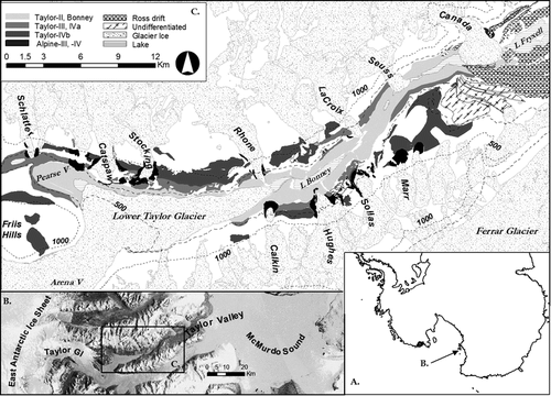
Still older matrix-rich drift and boulder-belt moraines mantle the valley sides above TIII drift up to at least 1000 m a.s.l. Over this vertical range, these sediments are characterized by numerous sets of ice-marginal features that become more discontinuous and influenced by gelifluction with increasing elevation. This drift clearly comprised multiple units of different age but, with insufficient evidence to subdivide it, we assigned it to TIV drift. Within TIV drift, we group boulder-belt moraines mapped by CitationWilch et al. (1993) as well as the silty tills found on Rhone platform beneath boulder-belt moraines. The ages of the silty tills at Rhone platform range from younger than 2.71 ± 0.24 My BP to older than 3.47 ± 0.05 My BP (CitationWilch et al., 1993).
Narrow, ice-cored moraines at the margins of many alpine glaciers today reflect the ongoing alpine glacier advance, referred to as AI. Ringing the margins of most alpine glaciers and extending outward a few hundred meters are narrow boulder-belt moraines and thin, discontinuous sandy gravel sheets. The gravel is varnished, ventifacted, and shows no sign of subglacial processing. This boulder-belt drift has been assigned to the AII glacial episode (CitationDenton et al., 1971; CitationLeide, 1980). Alpine II drift is draped over and distributed proximal to massive, 10–20 m high, rounded, and discontinuous alpine-glacier moraines. Commonly, two different generations of “bulky” (as opposed to boulder-belt moraines) alpine moraine remnants are present as indicated by crosscutting moraines or different stratigraphic relations to Taylor drift. The inner bulky moraine has traditionally been assigned to AIII drift; the outer, to AIV drift. They are shown in as combined AIII/IV drift.
The orientation of the remnant bulky moraines, approximately perpendicular to contour lines, implies that the associated advances of the alpine glaciers were largely out-of-phase with Taylor IV glacier advances (). Perhaps the bulky alpine moraines below 1000 m a.s.l. are younger than the Taylor boulder belts and silt-rich tills outcropping up to 1000 m a.s.l. on the Rhone platform, which would negate this interpretation. However, we do favor this explanation, because soil development is comparable on alpine and Taylor drifts (). Not only do the bulky Alpine III/IV drifts occur below 1000 m a.s.l., but also their distribution implies no blocking interference from Taylor Glacier.
TABLE 1 Properties of soils of Taylor Valley, Antarctica.
Ross I drift mantles the floor and sides of lower Taylor Valley (). This drift is draped over TII drift in front of Canada Glacier. Older generations of Ross drift crop out higher on the valley walls and also are draped onto the eastern face of Nussbaum Reigel. These are not well differentiated and so all Ross units are mapped as a single Ross drift category.
Permafrost Distribution in Taylor Valley
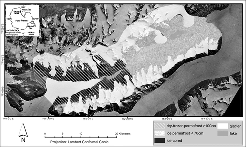
More than half of lower and central Taylor Valley contains ice-cemented permafrost (). Deposits containing ice-cemented permafrost include Ross and Bonney drift in the easternmost 28 km of the valley (). Ice-cemented permafrost is also present in Alpine II drift throughout the valley. Ice-cored drift is of limited extent in Taylor Valley and appears to be restricted to Holocene-aged Alpine I moraines along the north and south valley walls. Dry-frozen permafrost is prevalent in central and upper Taylor Valley, primarily in Taylor III and older drift and in Alpine III and IV drifts ().
FIGURE 2 Preliminary permafrost map of Taylor Valley. Place names referred to in the text are given in the caption of .
Soil Distribution in Taylor Valley
The youngest soils in Taylor Valley contain ground ice and are classified as Glacic Haploturbels. These soils occur on ice-cored Alpine I drift of Holocene age (). Soils in eastern Taylor Valley contain ice-cemented permafrost in the upper 70 cm of the solum and are strongly cryoturbated (Typic Haploturbels). The ice-cement results from melting of snow in the eastern part of the valley and the comparatively young geomorphic surfaces such as the Ross Sea () and Bonney () and Alpine II drifts. Typic Anhyorthels occur on Taylor III drift further upvalley in areas of dry-frozen permafrost (). These soils often have sand-wedge casts and presumably once contained ice-cemented permafrost.
FIGURE 3 Preliminary soils map of Taylor Valley. Place names referred to in the text are given in the caption of .
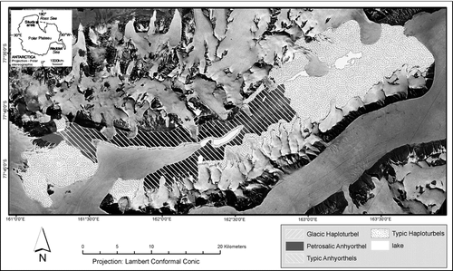
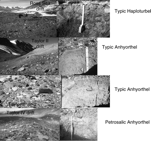
FIGURE 4 Landforms and soils on key drifts in Taylor Valley, including (A) a Typic Haploturbel on Ross Sea drift in eastern Taylor Valley, (B) a Typic Anhyorthel on Taylor II drift between the Sollas and Hughes Glaciers, (C) a Typic Anhyorthel on Taylor III drift below the Hughes Glacier, and (D) a Petrosalic Anhyorthel on Taylor IVa drift in Pearse Valley.
Salt-enriched soils (Salic Anhorthels) are common on Taylor IV drift on Andrews Ridge, above 1000 m along the LaCroix, Matterhorn, Stocking, and Catspaw Glaciers on the north valley wall, and in Pearse Valley (). Salic Anhyorthels also occur on Alpine III and IV drifts near the Marr, Sollas, Hughes, and Stocking Glaciers. Soils with salt-cemented horizons (Petrosalic Anyhyorthels) are of limited extent in Taylor Valley and are restricted to Taylor IV drift on the Rhone Platform and in Pearse Valley () and on Alpine IV surfaces near the Sollas and Stocking Glaciers.
Discussion
Glacial History of Taylor Valley
Taylor IV drift appears to contain multiple drift sheets, but we were unable to distinguish among these sheets. It is plausible that TIVa and TIVb drifts, which occur as boulder belts where defined in upper Taylor Valley, consist solely of boulder-belt moraines throughout Taylor Valley. The presence of Taylor boulder-belt moraines draped over silty Taylor basal till on Rhone platform constitutes positive evidence of multiple Taylor IV drifts. If this interpretation is correct, then these and similar silty tills high on central valley walls would likely reflect substantially different and older Taylor glaciations not appropriate for inclusion in TIVb drift. Boulder-belt moraines indicate cold-based ice and an absence of ice-marginal lakes. On the other hand, silty basal till often indicates active subglacial deposition by wet-based ice in the McMurdo Dry Valleys (CitationPrentice et al., 1993). We draw a distinction between silty basal till described by CitationWilch et al. (1993) and stratified glacial lake sediments contorted and reworked by cold-based ice, which is typical of TII drift.
Many issues regarding the bulky alpine glacier drift sheets in central Taylor Valley remain unresolved. These include the extent and number of Alpine III and IV drifts as well as their stratigraphic relations with Taylor Glacier drifts. CitationWilch et al. (1993) suggested that, in the Pliocene, alpine glaciers were, for the most part, no more extensive than they are today. However, we see at least two generations of bulky drift sheets that are modestly extensive.
The bulky moraine loops appear to be crosscut by Taylor Glacier drifts. This implies that the alpine glaciers were significantly expanded relative to their present positions at times in the Pliocene and that these expansions were out-of-phase with Taylor Glacier advances. According to CitationHiggins et al. (2000b), alpine glaciers in central Taylor Valley fluctuated in-phase with Taylor Glacier during the TII and TI advances. We think that the lateral boulder-belt moraines of Hughes, Lacroix, and Suess Glaciers crosscut Bonney drift. CitationHiggins et al. (2000b) proposed that the alpine glacier moraines merged with TII lateral moraines in central Taylor Valley.
Soil Properties in Relation to Drift Age in Taylor Valley
Soil properties in Taylor Valley are strongly related to drift age. For example, the depths of staining (primarily oxidation of iron-bearing minerals), coherence (consolidation from salts, iron oxides, or other soil constituents), visible salts, and ghosts (pseudomorphs of weathered rocks) and depth to ice-cemented permafrost increase with age (). Similarly, the salt and weathering stages and quantity of salts in the upper 70 cm of soil profile increase with drift age. Salt and weathering stages can readily be used to differentiate soils according to relative age. Surfaces from the Holocene and last glacial maximum lack staining, have minimal salts in the profile, and have salt and weathering stages of 1 (). Late Pleistocene soils are stained from 8 to 15 cm, contain visible salts from 6 to 18 cm, and have salt and weathering stages of 1.4–2.0 and 2.1–3.0, respectively. Early Pleistocene and Pliocene soils are deeply stained (≥33 cm) and have salt stages of 4.0–4.4 and weathering stages of 4.0–5.5.
TABLE 2 Comparison of soil development on approximately equivalent-aged drifts in Taylor Valley (TV) and Wright Valley (WV).1
Except on the mid-Holocene–aged Alpine I moraines, soil development is less in Taylor Valley than on roughly equivalent-aged surfaces in nearby Wright Valley (). These differences are primarily related to the threefold greater salt accumulation in soils of Wright Valley, which is important in weathering processes (CitationBockheim and McLeod, 2006). The greater amount of salts in Wright Valley is difficult to explain but may be due to a lower amount of precipitation (CitationDoran et al., 2002) and lesser leaching than in soils of similar age in Taylor Valley. Moreover, Wright Valley is broader than Taylor Valley in its upper reaches and more directly receives katabatic winds from the polar plateau, resulting in more arid conditions.
Permafrost Distribution in Taylor Valley
Unlike the upper Taylor Glacier region (Beacon Valley), ground ice is of limited extent in Taylor Valley and is restricted to ice-cored Alpine I drift of Holocene age.
Ice-cemented permafrost is dominant in Taylor Valley, particularly in the eastern half of the valley and adjacent to alpine glaciers. Dry-frozen permafrost results from sublimation of interstitial ice over time (CitationBockheim and Tarnocai, 1998; CitationBockheim and McLeod, 2006) and is manifested by the presence of fossil sand wedges (CitationBockheim, 2002). The maximum depth of dry-frozen permafrost in central and upper Taylor Valley is uncertain.
Conclusions
We draw several conclusions from our compilation of the surficial geology and soil development in lower and central Taylor Valley. The first is that at least one of the bulky alpine drifts in Taylor Valley is probably early Pleistocene to late Pliocene in age. Soils developed on this drift make it pre–late Pleistocene while incorporated volcanic clasts indicate that it is younger than 2.5 My BP. Soil development is comparable to that on Alpine III drift in central Wright Valley (CitationBockheim and McLeod, 2006) for which only a maximum date, 3.5 My BP, currently exists (CitationHall et al., 1993). If correct, this indicates that part of the Alpine III drift in Wright Valley, suggested by CitationPrentice and Krusic (2005) as being multiple, dates to the late Pliocene.
Another conclusion is that the morphology of the Taylor Alpine III/IV drift sheets, symmetrical in plan view, implies that these advances were largely out-of-phase with advances of Taylor Glacier. This contradicts the prevailing view of in-phase fluctuations (CitationDenton et al., 1993). Assuming both alpine and axial glacier systems are significantly influenced by regional climate change, an out-of-phase behavior implies that regional climate change has a spatial gradient and a causal influence. One possibility is that, in the Pliocene, Taylor Glacier was moderately restricted by the presence of Taylor Fjord, whereas the fjord may have enhanced alpine glacier advances.
The soils of Taylor Valley follow the evolutionary sequence observed in Wright Valley immediately to the north (CitationBockheim and McLeod, 2006). Holocene-aged surfaces contain Glacic Haploturbels; surfaces of late Quaternary age contain Typic Haploturbels; surfaces of late to mid-Quaternary age contain Typic Anhyorthels; surfaces of early Quaternary to late Pliocene age contain Salic Anhyorthels; and surfaces of mid- to early Pliocene age contain Petrosalic Anhyorthels. In Taylor Valley, ice-cemented permafrost is common within 28 km west of the coast and in Alpine II moraines; most of the remaining area to the upper Taylor Glacier contains dry-frozen permafrost. Ground ice is restricted to Holocene-aged Alpine I moraines.
The maps contained herein will be of use in understanding biodiversity and predicting the impacts of human activities on soils in Taylor Valley.
Acknowledgments
Funding from the OPP-NSF is gratefully acknowledged. We appreciate the opportunity to have worked with G. H. Denton over the years. D. Muhs offered many suggestions for improving the manuscript.
Related Research Data
References Cited
- Barrett, J. E. , R. A. Virginia , D. H. Wall , S. C. Cary , B. J. Adams , A. L. Hacker , and J. Aislabie . 2006. Co-variation in soil biodiversity and biogeochemistry in Northern and Southern Victoria Land, Antarctica. Antarctic Science 18:535–548.
- Bockheim, J. G. 1990. Soil development rates in the Transantarctic Mountains. Geoderma 47:59–77.
- Bockheim, J. G. 1995. Permafrost zonation in the Southern Circumpolar Region and its relation to the environment: a review and recommendations for further research. Permafrost and Periglacial Processes 6:27–45.
- Bockheim, J. G. 2002. Landform and soil development in the McMurdo Dry Valleys: a regional synthesis. Arctic, Antarctic, and Alpine Research 34:308–317.
- Bockheim, J. G. and M. McLeod . 2006. Soil formation in Wright Valley, Antarctica since the late Neogene. Geoderma 137:109–116.
- Bockheim, J. G. and C. Tarnocai . 1998. Nature, occurrence and origin of dry permafrost. In Proceedings of the Seventh International Conference on Permafrost, 23–27 June 1998, Yellowknife, Northwest Territories, Canada. 57–64.
- Campbell, I. B. 2000. Soil characteristics of a long-term ecological research site in Taylor Valley, Antarctica. Australian Journal of Soil Research 41:351–364.
- Campbell, I. B. and G. G. C. Claridge . 1975. Morphology and age relationships of Antarctic soils. In Suggate, R. P. and M. M. Cresswell , editors. Quaternary studies Wellington Royal Society of New Zealand. 83–88.
- Campbell, I. B. , G. G. C. Claridge , and M. R. Balks . 1994. The effect of human activities on moisture content of soils and underlying permafrost from the McMurdo Sound region, Antarctica. Antarctic Science 6:307–316.
- Campbell, I. B. , G. G. C. Claridge , D. I. Campbell , and M. R. Balks . 1997. The soil environment of the McMurdo Dry Valleys, Antarctica. In Priscu, J. , editor. The McMurdo Dry Valleys, Antarctica: a polar desert ecosystem Washington, D.C American Geophysical Union, Antarctic Research Series. 72:297–322.
- Denton, G. H. , R. L. Armstrong , and M. Stuiver . 1971. The late Cenozoic glacial history of Antarctica. In Turekian, K. K. , editor. The Late Cenozoic glacial ages New Haven Yale University Press. 267–306.
- Denton, G. H. , J. G. Bockheim , S. C. Wilson , and M. Stuiver . 1989. Late Wisconsin and early Holocene glacial history, inner Ross Embayment, Antarctica. Quaternary Research 31:151–182.
- Denton, G. H. , M. L. Prentice , and L. H. Burckle . 1991. Cainozoic history of the Antarctic ice sheet. In Tingey, R. J. , editor. The geology of Antarctica Oxford Clarendon Press. 365–433.
- Denton, G. H. , D. E. Sugden , D. R. Marchant , B. L. Hall , and T. I. Wilch . 1993. East Antarctic Ice Sheet sensitivity to Pliocene climate change from a Dry Valleys perspective. Geografiska Annaler 75A:155–204.
- Doran, P. T. , C. P. McKay , G. D. Clow , G. L. Dana , A. G. Fountain , T. Nylen , and W. B. Lyons . 2002. Valley floor climate observations from the McMurdo Dry Valleys, Antarctica, 1986–2000. Journal of Geophysical Research 107. No. D24, 4772, doi:10.1029/2001JD002045.
- Hall, B. L. and G. H. Denton . 2000a. Evidence from Taylor Valley for a grounded ice sheet in the Ross Sea, Antarctica. Geografiska Annaler 82A:275–303.
- Hall, B. L. and G. H. Denton . 2000b. Radiocarbon chronology of Ross Sea drift, eastern Taylor Valley, Antarctica: evidence for a grounded ice sheet in the Ross Sea at the last glacial maximum. Geografiska Annaler 82A:305–336.
- Hall, B. L. , G. H. Denton , D. R. Lux , and J. G. Bockheim . 1993. Late Tertiary Antarctic paleoclimate and ice-sheet dynamics inferred from surficial deposits in Wright Valley. Geografiska Annaler 75A:239–267.
- Hendy, C. L. , T. R. Healy , E. M. Rayner , J. Shaw , and J. T. Wilson . 1979. Late Pleistocene glacial chronology of the Taylor Valley, Antarctica and the global climate. Quaternary Research 11:172–184.
- Higgins, S. M. , G. H. Denton , and C. H. Hendy . 2000a. Glacial geomorphology of Bonney drift, Taylor Valley, Antarctica. Geografiska Annaler 82A:2–3 365–389.
- Higgins, S. M. , C. H. Hendy , and G. H. Denton . 2000b. Geochronology of Bonney drift, Taylor Valley, Antarctica: evidence for interglacial expansions of Taylor Glacier. Geografiska Annaler 82A:2–3 391–410.
- Leide, J. E. 1980. Soils and relative-age dating of alpine moraines in Wright and Taylor Valleys, Antarctica. Unpublished M.S. thesis. Madison, U.S.A Department of Soil Science, University of Wisconsin.
- Marchant, D. R. , G. H. Denton , and C. C. Swisher III . 1993. Miocene-Pliocene-Pleistocene glacial history of Arena Valley, Quartermain Mountains, Antarctica. Geografiska Annaler 75A:269–302.
- McCraw, J. D. 1967. Soils of Taylor Dry Valley, Victoria Land, Antarctica, with notes on soils from other localities. New Zealand Journal of Geology and Geophysics 10:498–539.
- Pastor, J. and J. G. Bockheim . 1980. Soil development on moraines of Taylor Glacier, lower Taylor Valley, Antarctica. Soil Science Society of America Journal 44:341–348.
- Péwé, T. L. 1960. Multiple glaciation in the McMurdo Sound region, Antarctica. Journal of Geology 68:498–514.
- Prentice, M. L. and A. G. Krusic . 2005. Early Pliocene alpine glaciation in Antarctica: terrestrial versus tidewater glaciers in Wright Valley. Geografiska Annaler 87A:87–109.
- Prentice, M. L. , G. H. Denton , J. G. Bockheim , S. C. Wilson , L. H. Burckle , D. A. Hodell , and D. E. Kellogg . 1993. Late Neogene glacial history: evidence from central Wright Valley. In Kennett, J. and D. Warnke , editors. The Antarctic paleoenvironment: A perspective on global change Washington, D.C American Geophysical Union, Antarctic Research Series. 60:207–250.
- Soil Survey Staff 1999. Soil taxonomy: a basic system of soil classification for making and interpreting soil surveys. 2nd edition Washington, D.C U.S. Department of Agriculture, U.S. Government Printing Office.
- Soil Survey Staff 2006. Keys to soil taxonomy. 10th edition Washington, D.C U.S. Department of Agriculture, Natural Resources Conservation Service.
- Stuiver, M. , I. C. Yang , G. H. Denton , and T. B. Kellogg . 1981. Oxygen isotope ratios of Antarctic permafrost and glacier ice. In McGinnis, L. D. , editor. Dry Valley Drilling Project American Geophysical Union, Antarctic Research Series. 33:131–139.
- Wilch, T. I. , G. H. Denton , D. R. Lux , and W. C. McIntosh . 1993. Limited Pliocene glacier extent and surface uplift in middle Taylor Valley, Antarctica. Geografiska Annaler 75:4A 331–351.