Abstract
A 1977 tundra fire burned a hillslope where prefire soils and vegetation ranged from poorly drained moist tussock-shrub tundra on the lower slopes to well-drained dwarf shrub tundra on the back slope and very poorly drained wet sedge meadow on the flat crest. We sampled the vegetation on this slope before the fire and at 8 sites following the fire at irregular intervals from 1 yr to 25 yr. During the first decade after the fire, short-term recovery was dominated by bryophytes, sedges, and grasses from both regrowing sedge tussocks and seedlings. However, during the second and third decade, and by 24 yr after the fire, evergreen (Ledum palustre) and deciduous shrubs (mainly Salix pulchra willow) expanded dramatically so that shrub cover was generally higher than before the fire. Labrador tea has increased by vegetative means on the poorly drained lowest 3 tussock-shrub tundra sites. Upslope on the better-drained and more severely burned tussock-shrub and dwarf shrub tundra sites, willows became established from seed mainly during the first 10 yr after the fire and, based on their relatively large size (0.5–1 m tall) and cover, have grown rapidly during the past 15 to 20 yr. There has been very little or no recovery of Sphagnum moss and fruticose lichens after 24 yr at any site, except for Sphagnum moss in the wet meadow site. The permafrost active layer thickness has diminished to prefire levels at the lower slope tussock-shrub tundra sites but is much greater or degraded completely on the steeper slope, corresponding with the distribution of willow shrub colonization. These changes in tundra vegetation and permafrost following fire suggest that such fires could accelerate the predicted effects of climate warming on ecosystems in the Arctic.
Introduction
One of the major uncertainties regarding the effects of climate change on terrestrial ecosystems in the Arctic is how warming will affect the extent and frequency of tundra wildfires and what effects such fire disturbance will have on tundra ecosystems. Such fires could exert landscape-scale controls on vegetation structure and composition, soil nutrients, carbon, herbivore forage, and permafrost dynamics. If tundra fire becomes more prevalent, it might change or accelerate predicted responses of the tundra system to climate warming (CitationChapin et al., 1995; CitationRupp et al., 2000). Fire may prepare seedbeds for shrub or tree invasion and increase rates of carbon release through direct combustion and increased rates of organic soil decomposition (CitationOechel, 1999). Changes in the structure of arctic tundra vegetation as a result of fire can also influence surface energy balance, including temperature, snow cover, and water (CitationMcFadden et al., 1998; Sturm et al., 2001b).
There is evidence that wildfire extent and frequency have already increased in the boreal forest as a result of warmer and drier conditions and that fire would be the likely agent for most vegetation change in the boreal zone under a changing climate (CitationStocks et al., 2000). Presently tundra fires are infrequent and restricted in the Alaskan Arctic to a limited area in the northwest, including the Seward Peninsula and Noatak River area (CitationRacine et al., 1985), but they would be expected to increase as well with a warming climate. CitationRupp et al. (2000) modeled the interactions between climate warming, fire, and vegetation on the Seward Peninsula, showing that rapid warming (+4°C) could cause a 228% increase in the total area burned per decade, due mainly to increased flammability.
During the very warm, dry summer of 1977 several large tundra wildfires occurred in northwest Alaska, including a 1000-km2 fire in the central Seward Peninsula (, ). One of the areas burned was a southwest-facing hillslope (Nimrod Hill) bordering the east side of Imuruk Lake (65°37′N, 163°07′W) () where vegetation and soils had been sampled before the fire in 1973. A set of permanent plots for monitoring recovery from the fire was established in 1978, and the first several years of recovery were described (CitationRacine et al., 1987). Observations we made in 2001 and 2002 extend this record of recovery into the third postfire decade.
In the Low Arctic, where most tundra fires occur, the zonal vegetation is tussock-shrub tundra with a vascular plant biomass of over 500 g/m2. Fire consumes most of this biomass but not the tussock bases and usually burns only the surface of the thick organic horizon, though it consumes the lichens and may burn or scorch the moss layer. After fire, tussock-shrub tundra plant cover and primary production and biomass recover quickly to prefire levels within 10 yr (CitationWein and Bliss, 1973; CitationRacine et al., 1983; CitationFetcher et al., 1984; CitationJandt and Meyers, 2000). However, much of this recovery is due to vigorous regrowth of graminoid sedges with much slower recovery of shrubs and lichens. Little is known about the medium-term (10–30 yr) postfire response of tundra vegetation. CitationVavrek et al. (1999) showed that tussock tundra vascular plant diversity recovered within 23 yr after fire, and CitationLandhausser and Wein (1993) found that 20 yr after a fire near treeline in western Canada, tall shrubs and deciduous trees were more abundant than before the fire. These studies of tundra fire recovery are limited to moist tussock-shrub tundra, which although regionally common does not represent the range of ecosystem structure and function along the toposequence presented here.
Study Area
Nimrod Hill is located in the central Seward Peninsula, which is at the “warm” end of an Alaskan arctic tundra gradient beginning at Barrow, about 400 km to the northeast. The site is less than 50 km from spruce treeline (). Kotzebue, the nearest and most representative long-term meteorological station (1949–present) for the Nimrod Hill study area, has a mean annual temperature of −5.8° C. The mean annual precipitation is 241 mm, with about half (105 mm) falling during June, July, and August. These three months have mean monthly precipitations of 14 mm, 36 mm, and 55 mm, respectively. The record low Kotzebue rainfalls for June and July (0.5 mm and 0.2 mm) occurred in 1977, when there were extensive tundra fires in northwest Alaska (). Tundra fires tend to occur in June and July, when solar radiation is high, drying takes place, and lightning storms cause ignitions.
White spruce treeline occurs along the eastern edge of the Seward Peninsula within 25 km of Imuruk Lake (). However, most of the peninsula is treeless, rolling tussock-shrub tundra with some smaller isolated mountain ranges and varied geologic substrates, including limestone, deep unglaciated loess, and lava flows of various ages. CitationJorgenson (2001) mapped the Nimrod Hill study area as occurring in the Imuruk Plateau and Imuruk Uplands underlain by Tertiary volcanic basalt and continuous permafrost.
Elevations on Nimrod Hill range from 360 m at the bottom of the slope to about 500 m on the crest over a distance of about 2000 m (). A profile of this southwest-facing slope is sigmoid (), beginning on a flat (2–3%) foot slope and rising slowly to a steeper 10–13% face or back slope, then leveling off to a 200-m-wide flat crest. A series of parallel willow-filled water track drainages (CitationHastings et al., 1989) occur at intervals of about 100 to 150 m across the entire slope ().
Soils along the slope vary from very poorly drained at the top and bottom of the slope to better drained on the back slope. CitationHolowaychuk and Smeck (1979) described soils they sampled here as acidic silt loam colluvium with 20- to 30-cm-thick organic horizons with a low pH (4.5). In mid-July 1973, thaw depths were about 25 cm. They reported frost features that included high-centered polygons on the footslope with small 50-cm-diameter frost boils covering less than 1% of the area, low-centered polygons on the level crest, and elongate turf-banked frost scars about 3 m in diameter and up to 0.75 m high on the back slope. They also found angular rock fragments of various sizes on the back slope and on the surface of the frost scars.
The prefire (1973) vegetation on the foot slope of Nimrod Hill consisted of tussock-shrub tundra extending upslope until the slope reached about 8% (). Dwarf shrub tundra then occupied the steeper back slope. A sedge wet meadow tundra occupied the level crest of the hill.
The fire in early to mid-July 1977 burned the entire Nimrod Hill slope except for larger willow water tracks. The severity of burning along the hillslope transect generally coincided with slope and drainage, with the fire consuming more vegetation and organic soil on the steep, well-drained backslope and less both downslope and up onto the flat crest ().
Methods
One yr after the fire, in mid-July 1978, we established 8 permanently marked sites from the foot slope to the crest of this hill at intervals of 200 to 300 m () and sampled vegetation and thaw depths. These sample sites were located as closely as possible to unmarked sites where soils and vegetation had been sampled in 1973, representing baseline prefire conditions. Because the fire burned almost the entire slope of Nimrod Hill except for water tracks, it was not feasible to locate unburned control sites in 1978.
At each site we placed 2 stakes 10 m apart, oriented in a magnetic north-south direction roughly parallel to the slope contours, and positioned 10 1 × 1–m sample plots on the downslope side of the line between the stakes, starting at the south end. All living plant species were recorded and an estimate of percent cover made for each species in each of the 1 × 1–m plots. Densities of seedlings, tussocks, and flowering stalks were also recorded. Thaw depths were determined by probing the center of each 1 × 1–m plot.
Sampling of the sites was repeated in 1979, 1980, and 1983 and summarized in CitationRacine et al. (1987). In mid-August 2001 we resampled the 8 sites on the Nimrod Hill transect using the same methods as in previous years. The sample data for each site and year were summarized by averaging the percent cover and density for each species over the 10 sample plots at each site. Frequency values for each species were also determined as the percentage of the 10 plots in which the species occurred.
In mid-August 2001 we saw abundant tall (>0.5 m) willows growing over much of the slope but particularly common on the well-drained portions. They had not been present before the fire or noticeable in 1983, when we had last sampled. Although abundant, these willows were not dense enough to be well represented in the 10 × 1–m belt transect at each site. We therefore sampled at random 18 willows growing in the vicinity of site 6, determining the canopy height and diameter, number of stems, species, and age by cutting the largest-diameter stem at ground level and counting the number of rings.
In July 2002 we established at each of sites 2, 5, 6, 7, and 8 a 5-m-wide by 100-m-long belt transect running along the contour out from the south end of each 10 × 1–m plot. We counted the number and species of willow clumps in each of 10 10 × 5–m plots along the 100-m belt transects and selected at random one or more willows in each of the these plots to measure canopy height and diameter, number of stems, and age by counting the number of rings on the largest-diameter stem cut at ground level. We also searched for evidence of burned stem bases on the measured willows to assess whether establishment could have been by resprouting rather than by seed.
Results
VEGETATION CHANGE
Tussock-Shrub Tundra (Foot Slope Sites 1–5)
The general prefire vegetation on the foot slope was tussock-shrub tundra with 43% graminoid tussock sedge cover (Eriophorum vaginatum and Carex bigelowii), 19% deciduous shrub cover (Betula nana, Vaccinium uliginosum), 20% evergreen shrub cover (Ledum palustre and Vaccinium vitis-idaea), 7%, lichen cover (mainly fruticose lichens Cladonia sp.) and 30% moss cover (mostly Sphagnum sp.) (). Fire burned the dead and live leaves of tussocks as well as the shrubs, mosses, and lichens, thus opening and exposing deep intertussock spaces and leaving only 3–5 tussock bases/m2.
New leaves developed rapidly from these tussock bases immediately after the fire, and a flush of cottongrass flowering was evident, particularly 3 to 6 yr after the fire. Within 6 to 10 yr total vascular plant cover was equal to prefire cover (). Abundant E. vaginatum seedlings (50/m2) appeared in the intertussock spaces by the first year after the fire and persisted for at least 6 yr with some tillering. After 24 yr, tussock density had increased an average of 0.3–0.4 tussocks/m2 compared to before the fire.
Overall, 24 yr after the fire, shrub cover at the 5 tussock-shrub tundra sites was equal to or greater than that before the fire (), with evergreen shrubs (mainly Ledum palustre) averaging 36% cover and dominating the shrub cover on the lowest 3 sites 1, 2, and 3 (), and deciduous birch and willow shrubs dominating (28% average cover) on the two better-drained tussock-shrub tundra sites 4 and 5 ( and ). Much of the cover increase in deciduous shrubs at sites 4 and 5 was produced by willow shrub (Salix pulchra) mainly at site 5 ( and ). Dwarf birch recovered slowly at all tussock-shrub tundra sites, remaining at less than 4% during the first 6 yr and reaching only 3 to 11% cover 24 yr after the fire ().
At all 5 tussock-shrub tundra sites, evergreen dwarf shrub species (L. palustre and V. vitis-idaea) resprouted 1 yr after the fire (100% frequency, ), but the percent cover at that time was only a trace. Labrador tea cover gradually increased to average 30% cover by 2001 at sites 1, 2, and 3 (). As a result, combined cover of evergreen shrubs was generally higher by 10–20% than before the fire at these 3 sites ().
Although Rubus chamaemorus was often the first to resprout and expand during the first few years after the fire, reaching 70 to 100% frequency within 1 yr and up to 7% cover in 6 yr after the fire, it did not exceed 10% cover after 24 yr (; ).
Moss cover before the fire was high (50–80%) and consisted mainly of Sphagnum sp. After the fire, scorched and burned Sphagnum cover remained at about 10% for the first 3 yr but may have been dead, and by the 24-yr point it was virtually absent in burned tussock-shrub tundra. The liverwort, Marchantia polymorpha, also appeared after the fire at low levels (1% cover) but was absent 24 yr after the fire ().
Lichen cover was 5–10% before the fire and included fruticose species such as Cladonia sp. and Cetraria sp. Twenty-four yr after the fire fruticose lichens occurred at high frequency but only trace cover, although the foliose lichen Peltigera sp. was more common ().
Dwarf Shrub Tundra (Back Slope Sites 6 and 7)
Prefire vegetation on the well-drained, steeper back slope included dwarf shrub tundra with turf-banked frost boils. The tops of these frost boils consisted of exposed mineral soil and a thin discontinuous cover of mosses, lichens, and dwarf shrubs. The dwarf shrub tundra between the frost boils was dominated by the shrubs Vaccinium uliginosum (20% cover), Betula nana (8%), Ledum palustre (6%), Vaccinium vitis-idaea (7%), and Empetrum nigrum (5%). The sedge Carex bigelowii cover was 10% and fruticose lichen 15% (). Burning here was generally severe, removing most of the organic soil and all of the dwarf shrub vegetation.
During the first 3 yr after the fire, bryophytes (mainly Ceratodon purpureus with smaller amounts of Marchantia polymorpha) dominated the site, and sedge seedlings (Carex bigelowii) rapidly increased to over 100/m2 (). Fireweed (Epilobium angustifolium) and bluejoint grass (Calamagrostis canadensis) also increased. Tillering of sedge seedlings increased, and by 1983 the site was dominated by graminoids with little evidence of shrub recovery and decreased bryophyte cover ().
By 24 yr after the fire, sedge meadow cover was still important, but there had also been a striking increase in willow shrubs (mainly S. pulchra) compared with the prefire vegetation, as shown by the pair of photos taken at site 6 in 1973 and 2001 (). Although the increase in willow shrubs was visually conspicuous, at the plot scale large willow cover increases occurred in only 3 of the 10 plots at site 7 and in only 1 of the 10 plots at site 6 (). Therefore, averaged cover values for deciduous willows at the 2 sample sites in 2001 was only about 15% (; ), although we visually estimated willow shrub cover over the back slope of Nimrod Hill at about 30 to 40%. Deciduous shrub cover was also high (28%) before the fire but consisted of dwarf blueberry and birch shrubs rather than the taller (0.5–1 m) willows in 2001.
Sedge Wet Meadow (Hill Crest Site 8)
Site 8 is located on the 200-m-wide crest of Nimrod Hill and before the fire in 1973 was dominated by a sedge wet meadow with Sphagnum hummocks. Sedge cover (Carex aquatilis) was 30% and Sphagnum moss 30%, with smaller amounts of both deciduous (7%) and evergreen (7%) shrubs, Rubus chamaemorus (3%), and lichen (10%) cover (). The severity of burning was patchy and light to moderate, with the tops of a few small mounds severely burned. During the 24 yr following the fire, the sedge Carex aquatilis recovered to levels greater than before the fire, but there was little or no shrub recovery (6%) (). No lichen recovery had occurred, and moss cover was almost 20% but consisted of both Sphagnum and Polytrichum rather than Sphagnum alone.
Willow Shrub Expansion and Timing
Twenty-five yr after the fire, willow shrubs were present over the entire slope of Nimrod Hill. However, most of this expansion had taken place on the better-drained sites 5, 6, and 7 where based on the 5 × 100–m belt transects, willow densities were 2480, 2100, and 2800 shrubs ha−1 compared with 600 and 880 ha−1 at the bottom (site 2) and top (site 8) of the slope, respectively. Most of the willow shrubs are Salix pulchra with some S. glauca and a few tall (>1 m) and scattered individuals of S. alaxensis. Of 50 willows sampled at sites 2, 5, 6, 7, and 8, we found only 1 to have a burned stem base, which together with measured ages between 7 and 23 yr suggests that virtually all of the willows became established after the fire from seed rather than by resprouting.
Accelerated growth of these willows was obvious by their large size relative to the surrounding vegetation () and to the 0.2–0.4-m height of willows before the fire. The average canopy height of 36 randomly sampled willows at sites 2, 5, 6, and 7 was 0.6 m, with an average crown diameter of 1.2 m and an average of 9 stems per shrub. The largest S. pulchra was a 20-yr-old shrub with 24 stems, 1.0 m tall, and with a crown diameter of 3.2 m.
Most (24) of the 44 random willow shrubs at sites 2, 5, 6, and 7 became established 6–10 yr after the fire (). Only 3 of the 44 shrubs were less than 10 yr old, suggesting little recent recruitment 15 to 25 yr after fire. Similarly, an age range of 11–16 yr for 4 willows at site 8 suggested little recent establishment here.
ACTIVE LAYER CHANGE
Because thaw depths were measured at each site in different years at different times of the thaw season and a control site was not available, it was difficult to detect changes in the active layer thickness in relation to time since the fire. However, we developed a seasonal thaw curve model for undisturbed tussock-shrub tundra on the Seward Peninsula from actual measurements made at different times during several field seasons (CitationRacine et al., 1983) ().
When the average thaw depth at each of the 5 tussock-shrub tundra sites on Nimrod Hill are plotted for the various years following the 1977 fire, the greatest difference in thaw at sites 1, 2, and 3 from the depth predicted by the model occurred during the second year (1979) (). The better-drained tussock-shrub tundra sites 4 and 5 thawed significantly deeper (10+ cm) than sites 1, 2, and 3 during the first 3 yr after the fire, and thaw depths at site 5 remained significantly deeper than those of the other 4 sites through 2001. In 1983 and 2001 thaw depths at sites 1, 2, 3, and 4 were similar to predicted unburned depths.
Although an average thaw depth of 25 cm was easily measured on the back slope before the fire in mid-July 1973, it was difficult to measure thaw depths at these 2 sites following the fire because the probe hit rock in over half of the plots. Where it was possible to measure thaw depth, values varied from 25 to 75 cm over short distances and were too variable for comparisons. The appearance of surface rocks on the back slope following the fire suggests that there may have been major permafrost thawing and surface subsidence, or “frost-jacking,” of stones in this area.
Thaw depth on the flat wet crest of Nimrod Hill (site 8) was 23 cm in mid-July 1973. Two yr after the fire, in late July 1979, thaw depth averaged 43 cm, and by the third year the thaw depth averaged 35 cm, as measured in early July. In mid-August 2001 the measured thaw was 41 cm.
Discussion and Conclusions
Twenty-four yr after a wildfire burned 3 types of low arctic tundra (tussock-shrub tundra, dwarf shrub tundra, and sedge wet meadow) distributed along the environmental gradient of a hillslope on the Seward Peninsula, the structure and composition of the vegetation were significantly different than those of the prefire vegetation. Shrubs were larger, more abundant, and of different species composition 24 yr after fire in both tussock-shrub tundra and dwarf shrub tundra. No recovery of Sphagnum moss or fruticose lichens, both common before the fire, has occurred at these sites. At a sedge wet meadow site, sedge cover is higher than before the fire and Sphagnum moss cover remains high.
The evergreen shrub Ledum palustre cover was greater after 24 yr than before the fire on the 3 lowest and less severely burned tussock-shrub tundra sites. This increase appears to have occurred through growth of belowground portions of plants that survived the fire and began resprouting the first year. Others have noted such an increase in Labrador tea 14 to 20 yr after a fire (Fetcher et al., 1983; Jandt and Myers, 2001). CitationHobbie et al. (1999) found an increase in L. palustre biomass and reproduction, both with experimental removal of other shrub species or Spagnum moss and with soil warming.
The most dramatic and conspicuous vegetation change occurred on the better-drained portions of the slope in both tussock-shrub tundra and dwarf shrub tundra, where numerous willow shrubs became established from seed 6 to 10 yr after the fire and by August 2001 were large and fast growing. Other studies of tussock-shrub tundra recovery from fire (CitationJandt and Meyers, 2000; CitationVavrek et al., 1999) have not noted an expansion of willow shrubs 14 to 23 yr after fire. However, these studies did not include better-drained sites with greater fire severity. CitationLandhausaer and Wein (1993) described a severely burned tundra site near treeline in western Canada where shrubs (both Ledum palustre and Betula glandulosa) had become dominant 22 yr after the fire. Trees such as Betula papyrifera and Populus balsamifera also invaded the burned tundra areas, suggesting that fire could accelerate the movement of treeline in response to climate warming by exposing patches of mineral soil for tree and shrub seed germination.
Similarly, on Nimrod Hill the greatest willow expansion corresponds with the area of deeper permafrost thawing, where burning was more severe and removed enough organic soil to create patches of mineral soil in which willow seed germination could take place. Willow establishment began within 1 yr but peaked 6 to 10 yr after the fire (Fig. 8). The absence of continued willow establishment during the past 10 yr may be due to the buildup of organic soil and vegetation. The large size of the willows is likely due to the warmer soils and nutrient enrichment resulting from the fire but has also occurred during a period of rapid climate warming in the Alaskan Arctic (CitationSerreze et al., 2000).
Tundra fire on Nimrod Hill has accelerated the predicted effects of climate warming on arctic tundra by increasing the percent cover of deciduous shrubs. However, there are differences between the expansion of deciduous shrubs observed on Nimrod Hill and that predicted by experiments. On Nimrod Hill we observed deciduous shrub expansion to result from new willow shrubs originating from seed. However, experimental warming and fertilization of tussock-shrub tundra increased the size and branching of birch (Betula nana) already present in the vegetation (CitationChapin et al., 1995; CitationBret-Harte et al., 2001). On Nimrod Hill shrub birch recovered to prefire levels in the tussock-shrub tundra and appears to be growing well but has not increased as dramatically as willow in size and cover.
Shrub expansion has also been documented over Alaskan arctic landscapes without fire during the past 50 yr (Sturm et al., 2001a), and in the Seward Peninsula CitationSilapaswan et al. (2001) used remote sensing to demonstrate increased shrub cover from 1986 to 1999. As a result of modeled increases in climate warming, fire, and drought on the Seward Peninsula, CitationRupp et al. (2000) predicted vegetation succession from upland tundra (present vegetation) to deciduous forest or grassland-steppe. Hence, these results from Nimrod Hill emphasize the complexity of possible interactions between climate warming, fire, and vegetation change (Campbell and Flannigan, 2000).
Of particular importance for carbon, energy, and herbivore dynamics is the direction of recovery on Nimrod Hill with respect to shrubs. Tundra fires generally accelerate carbon loss due to both direct burning and subsequent warming of soils causing higher rates of decomposition. In 1993 and 1994 Oechel and associates measured carbon flux in tussock tundra at the same Nimrod Hill site (16–17 yr postfire) and at an additional 9 sites in the Seward Peninsula that were burned 1–22 yr ago (CitationOechel, 1999). Their results suggest that for at least 2 decades following fire, tussock tundra in the Seward Peninsula was a source rather than sink for CO2 due to warmer soils and higher rates of decomposition. The shrub expansion observed here could theoretically offset some to much of this source activity during the growing season because of the higher rates of photosynthesis by shrubs and carbon storage in wood. However, because the expansion of willow shrubs at Imuruk Lake has occurred more at a landscape than a plot scale, it might not be detected by localized carbon flux measurements.
FIGURE 1. Map of the Seward Peninsula showing the location of several 1977 fires (crosshatched areas), treeline, and the Imuruk Lake study site
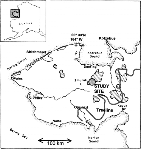
FIGURE 2. Aerial oblique photo (August 2001) of Nimrod Hill, where a 2-km-long transect was sampled before a 1977 tundra fire and at 8 locations (shown with arrows) from 1 to 24 yr postfire
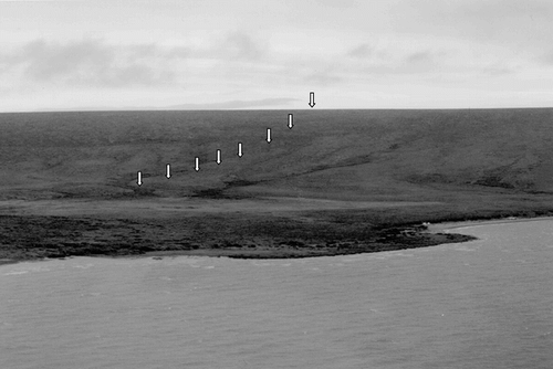
FIGURE 3. Profile of Nimrod Hill showing location of sites in relation to slope, vegetation type, and burn severity
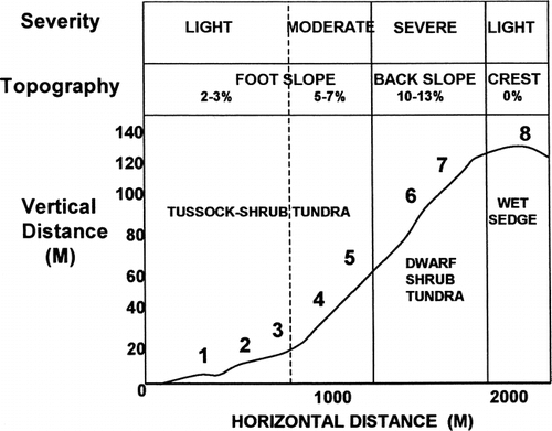
FIGURE 4. Bar graphs showing percent cover of vascular plant functional groups for (a) tussock-shrub tundra sites 1, 2, and 3 and for (b) tussock-shrub tundra sites 4 and 5
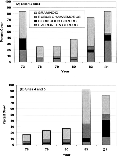
FIGURE 5. Bar graph showing percent cover of vascular plant functional groups at sites 6 and 7 prefire and at various intervals following the 1977 tundra fire
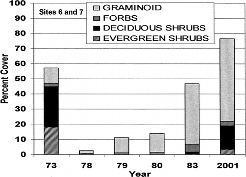
FIGURE 6. Photos taken from site 6 on the back slope of Nimrod Hill to the west toward Imuruk Lake (a) July 1973, 4 yr before a 1977 tundra fire, and (b) August 2001, 24 yr after fire. Note change in abundance of willow shrubs in the foreground
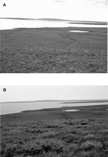
FIGURE 7. Bar graph showing the percent vascular cover of plant functional groups at site 8 on the flat crest of Nimrod Hill, where a sedge-Sphagnum wet meadow was present before the fire
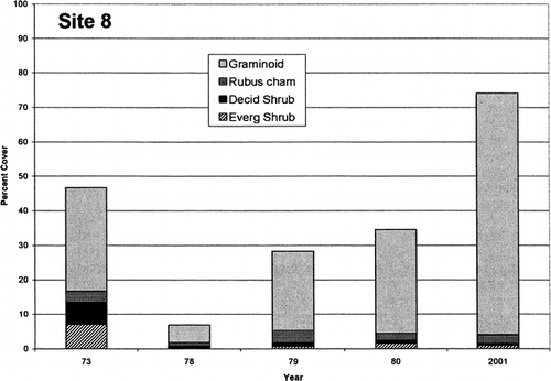
FIGURE 8. Bar graph showing the number of Salix pulchra shrubs that became established at different time intervals following the 1977 tundra fire at sites 2, 5, 6, and 7 on Nimrod Hill. Age was determined by counting the number of annual rings at the base of the largest stem on 44 randomly sampled willow shrubs
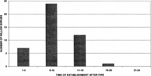
FIGURE 9. Seasonal thaw curve for undisturbed tussock-shrub tundra (solid line) in the Imuruk Lake area and averaged thaw depths (n = 10) at 5 tussock-shrub tundra sites burned in 1977 and measured at various times postfire from 1 to 24 yr
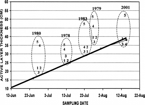
Table 1 Seward Peninsula fire sites considered here or in other studies
Table 2 Frequency (F) and Cover (C) percentages for species sampled in 10 contiguous 1 × 1–m quadrats at each of the 5 ft slope tussock-shrub tundra sites 1 (1978), 3 (1980), and 24 (2001) yr after a 1977 tundra fire on Nimrod Hill in the central Seaward Peninsula. Prefire values in 1973 were generalized for the foot slope
Table 3 Frequency (F) and cover (C) percentages for species in dwarf-shrub tundra on the back slope of Nimrod Hill (sites 6 and 7) sampled at each site in 10 contiguous 1 × 1–m quadrats, prior to (1973) and at intervals of 1 (1978), 2 (1979), 3 (1980), 6 (1983), and 24 (2001) yr after the 1977 tundra fire
Table 4 Frequency (F) and cover (C) percentages for species in sedge wet meadow tundra at site 8 on the crest of Nimrod Hill before the fire (1973) and 1 (1978), 2 (1979), 3 (1980), and 24 yr (2001) postfire
Acknowledgments
The study was supported by the Department of the Interior, Bureau of Land Management (BLM), Alaska Fire Service, and Northern Field Office. Some logistical support was provided by the National Science Foundation and National Park Service. Jeanie Cole, Marilyn Racine, and Jed Dennis helped with the field and laboratory work. Matthew Sturm reviewed the manuscript.
Related Research Data
References Cited
- Bret-Harte, M. S. , G. R. Shaver , J. P. Zoerner , J. F. Johnstone , J. L. Wagner , A. S. Chavez , R. F. Gunkelman, IV , S. C. Lippert , and J. A. Laundre . 2001. Developmental plasticity allows Betula to dominate tundra subjected to an altered environment. Ecology 82:18–32.
- Campbell, I. D. and M. D. Flannigan . 2000. Long-term perspective on fire-climate-vegetation relationships in the North American Boreal forest. In Kasischke, E. S., and Stocks, B. J. (eds.), Fire, Climate Change and Carbon Cycling in the Boreal Forest. New York: Springer-Verlag, 151–172.
- Chapin III, F. S. , G. R. Shaver , A. E. Giblin , K. J. Nadelhoffer , and J. A. Laundre . 1995. Responses of arctic tundra to experimenatal and observed changes in climate. Ecology 76:694–711.
- Fetcher, N. , T. F. Beatty , B. Mullinax , and D. S. Winkler . 1984. Changes in arctic tussock tundra thirteen years after fire. Ecology 65:1332–1333.
- Hastings, S. J. , S. A. Luchessa , W. C. Oechel , and J. D. Tenhunen . 1989. Standing biomass and production in water drainages of the foothills of the Phillip Smith Mountains, Alaska. Holarctic Ecology 12:304–311.
- Hobbie, S. E. , A. Shevtsova , and F. S. Chapin III . 1999. Plant responses to species removal and experimental warming in Alaskan tussock tundra. Oikos 84:417–434.
- Holowaychuk, N. and N. E. Smeck . 1979. Soils of the Chucki-Imuruk area. In Melchior, H. R. (ed.), Biological Survey of the Bering Land Bridge National Monument. Fairbanks: Alaska Cooperative Park Studies Unit, University of Alaska, 114–192.
- Jandt, R. R. and C. R. Meyers . 2000. Recovery of lichen in tussock tundra following fire in northwestern Alaska. BLM-Alaska Open File Report 82.
- Jorgenson, M. T. 2001. Landscape-level mapping of ecological units for the Bering Land Bridge National Preserve. Final Report prepared for National Park Service, Anchorage, AK, by ABR, Inc., Fairbanks, AK. 45 pp. http://www.nps.gov/akso/gis/bela/belaBiol.htm#subse_be.shp .
- Landhausser, S. M. and R. W. Wein . 1993. Postfire vegetation recovery and tree establishment at the arctic treeline: climate-change-vegetation-response hypotheses. Journal of Ecology 81:665–672.
- McFadden, J. P. , F. S. Chapin III , and D. Y. Hollinger . 1998. Subgrid-scale variability in the surface energy balance of arctic tundra. Journal of Geophysical Research 103:28947–28961.
- Oechel, W. C. 1999. Net ecosystem carbon flux of age-specific subarctic tussock tundra stands following fire: implications for Alaska Interagency Fire Management. Final Report to National Park Service, Boise, ID.
- Racine, C. H. , W. A. Patterson III , and J. G. Dennis . 1983. Permafrost thaw associated with tundra fires in northwest Alaska. In Permafrost: Fourth International Conference Proceedings. Washington, DC: National Academy Press, 1024–1029.
- Racine, C. H. , W. A. Patterson III , and J. G. Dennis . 1985. Tundra fire regimes in the Noatak River Watershed, Alaska: 1956–1983. Arctic 38:194–200.
- Racine, C. H. , L. A. Johnson , and L. A. Viereck . 1987. Patterns of vegetation recovery after tundra fires in northwestern Alaska, U.S.A. Arctic and Alpine Research 19:461–469.
- Rupp, T. S. , F. S. Chapin III , and A. M. Starfield . 2000. Response of subarctic vegetation to transient climatic change on the Seward Peninsula in north-west Alaska. Global Change Biology 6:541–555.
- Serreze, M. C. , J. E. Walsh , F. S. Chapin III , T. Osterkamp , M. Dyurgerov , V. Romanovsky , W. C. Oechel , J. Morison , T. Zhang , and R. G. Barry . 2000. Observational evidence of recent change in the northern high-latitude environment. Climatic Change 46:159–207.
- Silapaswan, C. S. , D. L. Verbyla , and A. D. McGuire . 2001. Land cover change on the Seward Peninsula: the use of remote sensing to evaluate the potential influences of climate warming on historical vegetation dynamics. Canadian Journal of Remote Sensing 27:542–554.
- Stocks, B. J. , M. A. Fosberg , M. B. Wotten , T. J. Lynham , and K. C. Ryan . 2000. Climate change and forest fire activity in North Amerian boreal forests. In Kasischke, E. S., and Stocks, B. J. (eds.), Fire, Climate Change and Carbon Cycling in the Boreal Forest. New York: Springer-Verlag, 368–376.
- Sturm, M. , C. Racine , and K. Tape . 2001a. Increasing shrub abundance in the Arctic. Nature 411:546–547.
- Sturm, M. , J. P. McFadden , G. E. Liston , F. S. Chapin III , and C. H. Racine . 2001b. Snow-shrub interactions in arctic tundra: a hypothesis with climate implications. Journal of Climate 14:336–344.
- Vavrek, M. C. , N. Fetcher , J. B. McGraw , G. R. Shaver , F. S. Chapin III , and B. Bovard . 1999. Recovery of productivity and species diversity in tussock tundra following disturbance. Arctic, Antarctic, and Alpine Research 31:254–258.
- Wein, R. W. and L. C. Bliss . 1973. Changes in arctic Eriophorum tussock communities following fire. Ecology 54:845–852.