Abstract
A process geomorphological investigation was started in 1999 to study present denudation rates and the mutual relationship of chemical and mechanical fluvial denudation in periglacial environments. Latnjavagge (9 km2; 950–1440 m a.s.l.; 68°20′N, 18°30′E) was chosen as a representative drainage basin of the arctic-oceanic mountain area in northernmost Swedish Lapland. Atmospheric solute inputs, chemical denudation, and mechanical fluvial denudation were analyzed. During the arctic summer field seasons of 2000, 2001, and 2002 measurements of daily precipitation, solute concentrations in precipitation, and in melted snow cores, taken before snowmelt, were recorded. In addition, solute and suspended sediment concentrations in creeks were analyzed, and bedload tracer movements were registered during the entire summer seasons (end of May until beginning of September). Results show a mean annual chemical denudation net rate of 5.4 t km−2 yr−1 in the entire catchment. Chemical denudation in Latnjavagge is less than one third of chemical denudation rates reported for Kärkevagge (Swedish Lapland) but seems to be at a similar level as in a number of other subarctic, arctic, and alpine environments. Mechanical fluvial denudation is lower than chemical denudation. Most sediment transport in channels occurs in the early summer season during a few days with snowmelt generated runoff peaks. The main sediment sources in the drainage basin are mobilized channel bed pavements exposing fines, ice patches/fields, and material mobilized by slush flows. The calculated mean mechanical fluvial denudation rate is 2.3 t km−2 yr−1 at the inlet of lake Latnjajaure, situated in Latnjavagge close to the outlet of the valley. A very stable vegetation cover and rhyzosphere in this environment mainly explain the low value. The mean mechanical fluvial denudation rate at the outlet of the entire Latnjavagge drainage basin, below lake Latnjajaure, is only 0.8 t km−2 yr−1. Both chemical and mechanical fluvial denudation show low intensity. The results from Latnjavagge support the contention that chemical denudation is a somewhat important denudational process in periglacial environments.
Introduction
CHEMICAL AND MECHANICAL FLUVIAL DENUDATION IN PERIGLACIAL ENVIRONMENTS
Essential parts for an interpretation of landscape evolution are the analyses of sediment fluxes, denudation rates, and sediment budgets in fluvial drainage basins. Unfortunately there is yet little quantitative data available on fluvial sediment transfers and sediment budgets in present periglacial environments (CitationClark, 1988; CitationBarsch et al., 1994; CitationGude and Scherer, 1999; CitationBeylich, 1999, Citation2000a, Citation2000b). Therefore additional quantitative investigations on contemporary fluvial sediment budgets are needed to examine relationships between chemical denudation and mechanical fluvial denudation in periglacial environments. Remarkable is the lack of studies investigating rates of both chemical and mechanical fluvial denudation simultaneously. Process intensities and relative importance of different denudative processes under various environmental conditions are further questions that need quantitative examination of present-day sediment budgets in different periglacial environments (CitationBeylich, 1999, Citation2000a, Citation2002).
For many years, the effects of chemical weathering and chemical denudation were considered less important in periglacial environments (e.g., CitationCampbell et al., 2001). In contrast to early work by CitationVon Lozinski (1909, Citation1912) and CitationPeltier (1950), postulating a minor role of chemical denudation in cold environments, CitationRapp (1960) concluded that chemical denudation was by far the most important geomorphological process in Kärkevagge, northernmost Swedish Lapland. Subsequently, research in various periglacial environments in different parts of the world has shown that chemical weathering and denudation are significant processes in cold environments (CitationReynolds and Johnson, 1972; CitationThorn, 1975; CitationCaine, 1979, Citation1995; CitationDixon et al., 1984, Citation1995; CitationCaine and Thurman, 1990; CitationBeylich, 1999, Citation2000a; CitationDarmody et al., 2000, Citation2001; CitationCampbell et al., 2001, Citation2002; CitationThorn et al., 2001). Relatively high chemical denudation rates were reported in oceanic periglacial environments with high annual precipitation despite of low solute concentrations in the runoff (CitationBeylich, 1999, Citation2000a, Citation2000b, Citation2003).
The fluvial transport of solids in periglacial environments is in general strongly confined to floods generated by snowmelt, rainfall, or a combination of both (CitationBarsch et al., 1994; CitationGintz and Schmidt, 1998, Citation2000; CitationBeylich, 1999, Citation2000a; CitationGude and Scherer, 1999; CitationJonasson and Nyberg, 1999; CitationBeylich and Gintz, 2004). Several authors have stressed the significance of such high-magnitude/low-frequency fluvial events for sediment transport and landform change (see CitationBrunsden, 1996; CitationBeylich and Gintz, 2004).
With a change in climate, a change in type and/or intensity of earth surface processes will induce changes in the corresponding sediment fluxes on slopes and in channels. A better understanding of geomorphological processes operating in present “morphoclimates” (CitationAhnert, 1986, Citation1987) can contribute to more reliable assessments of possible geomorphological effects of climate change (CitationBarsch, 1993; CitationSchlyter et al., 1993; CitationRapp, 1995; CitationBeylich, 1999, Citation2000a, Citation2000b, Citation2002, Citation2003).
The comparison of sediment budgets of selected representative drainage basins of similar size in present-day periglacial environments with special morphoclimatic, topographic, lithological/geological, and tectonic features can help to give insight into internal differentiation of the periglacial environments (see CitationBarsch, 1984, Citation1986). Such data can give information on control mechanisms of periglacial processes and on intensity and relative importance of denudative processes in different environmental conditions (CitationBeylich, 1999, Citation2000a, Citation2002).
An investigation was started in 1999 in Latnjavagge (9 km2; 950–1440 m a.s.l.; 68°20′N, 18°30′E), a drainage basin comprising principal lithological/geological and geomorphological characteristics representative of the higher, arctic-oceanic mountain area in northernmost Swedish Lapland. The study's major goal was to collect additional quantitative data for an analysis of the internal differentiation of the present-day periglacial environments and to understand better present sediment fluxes, denudation rates, and the mutual relationship of chemical and mechanical denudation in a periglacial environment with special environmental conditions (CitationBeylich, 2001, Citation2002, Citation2003; CitationBeylich and Gintz, 2004; CitationBeylich et al., 2003, Citation2004a; Citation2004b). Over a period of 3 yr, denudative geomorphological processes in this drainage basin in the Abisko mountain area were monitored and quantified (, ). In this paper the absolute magnitude and the relative importance of chemical and mechanical fluvial denudation are presented and discussed for this specific arctic-oceanic periglacial environment on the basis of data collected during the arctic summer field seasons of 2000, 2001, and 2002.
STUDY AREA
The mountains of northernmost Swedish Lapland are situated close to the North Atlantic in a prevailing westerly wind regime. In terms of climate, the northerly position of the area is partly modified by the favorable influence of the Gulf Stream. The arctic-oceanic climate at the Latnjajaure Field Station (LFS, 981 m a.s.l.) is characterized by an annual mean temperature of −2.3°C (length of record available: 1993–2001) and a mean annual precipitation of 818 mm yr−1 (length of record available: 1990–2001). July is the warmest month of the year (8.0°C), whereas February is the coldest month (−10.1°C). Approximately two thirds of the annual precipitation is temporarily accumulated as snow during winter. In summer (June to August), August not only shows the highest mean precipitation (82 mm) but also the highest frequency of extreme rainfall events. Altogether, precipitation from June to August accounts for 24% of the mean annual precipitation (CitationBeylich, 2003).
The Latnjavagge basin drains to the south into the larger Kårsavagge. Its area is approximately 9 km2, with a length of 4600 m and an elevation ranging from 950 to 1440 m a.s.l. The bedrock of Latnjavagge is mainly composed of Cambro–Silurian mica-garnet schists with inclusions of marble (CitationKulling, 1964; CitationKling, 2005). Intrusions of acidic granites can be found in the northern part of the valley. Regional deglaciation occurred about 8000–10,000 yr BP (CitationAndré, 1995). The Latnjavagge drainage basin is dominated by flat plateau areas at 1300 m a.s.l., which surround the glacially sculptured valley. The flat valley floor is situated between 950 and 1200 m a.s.l., bounded by steep slopes (). Bare bedrock and boulder fields characterize the plateau areas with a generally abrupt transition to the valley-side slopes. Perennial snow and ice patches cover the uppermost parts of the very steep, east-facing slope. The lower part of the valley floor is dominated by a lake, Latnjajaure, (0.73 km2) and a series of moraine ridges. Generally the regolith thicknesses only locally reach more then a few meters (CitationBeylich et al., 2004b). Soils are mainly regosols and lithosols.
The area belongs to the mid-alpine zone with a continuous vegetation cover comprising dwarf shrub heaths, alpine meadows, and bogs (CitationMolau, 2001, Citation2005; CitationMolau et al., 2003). The distribution of permafrost is still not thoroughly investigated, but drilling at 1200 m a.s.l. outside the drainage basin suggested at least sporadic permafrost down to 80 m below surface (CitationKling, 1996, Citation2005). Permafrost is expected in the northwestern part of the drainage basin, whereas ice-rich permafrost seems absent at around 1000 m a.s.l. (CitationBeylich et al., 2004b).
Active slope processes are chemical weathering and denudation, frost weathering, rock falls, boulder falls, plowing boulders, avalanches, slush flows, debris flows and slides, solifluction/gelifluction, creep processes, aquatic slope denudation, and deflation. In the main channels dissolved solids, suspended sediments, and bedload are transported. The hydrological regime is nival, with runoff being limited to the period from the end of May until October/November. Direct anthropogenic impact on the natural system is small and is restricted to extensive reindeer grazing, some hiking tourism, and research at the Latnjajaure Field Station (CitationBeylich et al., 2005).
AIMS OF THE STUDY
The aims of this study are to (1) quantify atmospheric solute inputs, (2) quantify chemical denudation in Latnjavagge, (3) quantify mechanical fluvial denudation in the Latnjavagge drainage basin, and (4) compare the relative importance of present-day chemical and mechanical fluvial denudation in this arctic-oceanic periglacial environment. The results of these investigations will lead to a better understanding of process intensities and clarify the relative denudative importance of different process types in various environmental conditions. Deeper knowledge of spatial differentiation of the periglacial environments will be gained through further quantitative data on present-day sediment budgets from different periglacial environments.
Approach and Methods
The Latnjavagge drainage basin can be seen as representative test site for the arctic-oceanic mountain area in northernmost Swedish Lapland and exhibits major geomorphological-geological characteristics of this periglacial environment. Fieldwork was conducted during the arctic summer field seasons of 2000, 2001, and 2002. During these seasons discharge measurements and samplings were carried out daily or three times daily, respectively, at the different measuring sites (). This paper focuses on basin-wide total denudation rates, calculated from daily precipitation, runoff, concentration, and yield data.
SELECTION OF SUBCATCHMENTS, MEASURING SITES AND SAMPLING SITES
The Latnjavagge drainage basin is composed mainly of Cambro–Silurian mica-garnet schists and can be regarded as lithologically/geologically homogeneous. The selected subcatchments, measuring sites as well as sampling sites and profiles are shown in . They were selected after an analysis of topographical maps and aerial photographs of the area, completed by detailed field investigations. Discharge measurements and water sampling for analysis of solute and suspended sediment concentrations were conducted at the inlet and outlet of lake Latnjajaure and at the outlet of the entire Latnjavagge drainage basin. Snow sampling was carried out along selected profiles within Latnjavagge. The Latnjajaure Field Station (LFS, 981 m a.s.l.) provided meteorological and soil temperature data (CitationMolau, 2001; Citation2005; CitationMolau et al., 2003) (). Lake Latnjajaure was expected to be a major sediment trap within the Latnjajaure drainage basin (see CitationJonasson, 1991). Measurements were therefore conducted at both the inlet and outlet of the lake. The locations for channel discharge measurements and water sampling were selected at channel sites with clearly defined cross sections ().
FIELD MEASUREMENTS AND SAMPLINGS
The Latnjajaure Field Station (LFS, 981 m a.s.l.) is equipped with an automatic weather station. The temperature sensors are installed in a standard Stevenson Screen at 2 m above ground, recording hourly means, maxima, and minima. During summers, precipitation is measured daily with readings at 0700 h Normal Time using a precipitation gauge (Hellmann-Totalisator, 200 cm2 surface are) with wind shelter, according to Sveriges Meteorologiska och Hydrologiska Institut (SMHI) standards (see CitationMolau, 2001).
Three times daily, immediately prior to water sampling, channel discharge was measured at the different measuring sites () using an Ott-propeller C2 (Ott GmbH & Co.KG, Kempten). Stream velocity data was collected at well-defined channel cross sections, each cross section with measuring points at horizontal distances of 10 cm and at 60% of the total water depth. Velocity-isolines were calculated by interpolation for datasets from each channel cross-sections. Discharge (m3 s−1) was calculated through multiplying velocity (m s−1) by the corresponding cross-section areas. Daily discharge (m3 d−1) was estimated for the different channels by interpolating the three daily measurements. Daily specific runoff (mm d−1) was then calculated, dividing the daily discharges by the contributing (sub)catchment areas (see CitationBeylich, 1999). Fixed gauge stations providing continuous discharge measurements could not be installed due to the characteristics of the channels (bedrock and/or blocks, shifting channels during snowmelt and slush flow activity in the valley). Shifting channels during snowmelt made repeated measurements of cross sections necessary, especially above lake Latnjajaure.
Surface water electric conductivity (μS cm−1, reference 25°C) was measured at the different sampling sites (). Readings were taken immediately after the discharge measurements with a temperature-corrected portable instrument (Cond 315i/SET, WTW Weilheim). Total dissolved solids (TDS) in surface water samples, in precipitation, and snowpack were estimated by multiplying conductivity by 0.7 (see CitationStrömquist and Rehn, 1981; CitationDarmody et al., 2000). This factor was determined for Kärkevagge, situated a few kilometers northwest of Latnjavagge and therefore expected to provide reliable values also for Latnjavagge. Mean daily discharge weighted TDS values (mg L−1) of surface water samples were calculated by interpolation of the three daily measurements from each site (CitationBeylich, 1999). For practical reasons and because of a minor temporal variability within the conductivity measurements, three readings were done per 24 h and regarded as an acceptable approximation to a more continuous recording series.
Water samples obtained in the field were surface water (1-L samples), precipitation samples (precipitation gauge; Hellmann-Totalisator, surface area 200 cm2), and melted snow samples (plastic tube, 10 cm diameter, following profiles, see ). The water samples were filtered (see below) and stored in 200-ml polyethylene bottles in a freezing box at LFS. The frozen samples (freezing box) were transported to Berlin and analyzed at the laboratory of FU Berlin, FB Earth Sciences, Institute for Geological Sciences, AB Hydrogeology. Na+ and K+ ions were determined using a “Flammenphotometer Eppendorf Elex 6361” and Ca2+, Mg2+, Fe2+, Mn2+ were detected with an AAS Perkin-Elmer 5000. The SO4 2−, Cl−, NO3 − contents were measured with an ion–chromatograph (DX 100 Dionex) and PO4 3− with an autoanalyzer II Technicon. Mn2+ and PO4 3− were below the detection limit in all surface water samples (CitationBeylich et al., 2004a). All analyses were conducted in accordance with regulations given by the instrument manufacturers.
Directly after the channel discharge measurements, vertically integrated water samples (1 L) were taken manually with wide-neck bottles (polyethylene). The samples were filtered in the laboratory at the Latnjajaure Field Station with a pressure filter and ash-free filter papers (MUNKTELL Analytical Filter Papers: 11 cm diameter; Quality 00H: “Retains extremely fine precipitates”). After the field seasons the filter papers were burned (12 h, 550°C) in the laboratory at the Department of Earth Sciences, Uppsala University, and concentrations of minerogenic suspended solids (mg L−1) were analyzed and weighted. Daily discharge weighted suspended sediment concentrations were calculated by interpolating the three daily measurements from each site (see CitationBeylich, 1999). Three measurements per 24 h were regarded as a sufficient approximation to a more continuous recording series considering the generally very low suspended sediment concentrations in Latnjavagge (see below) and the comparatively small temporal variability of concentration values. Because of high water turbulence at all sampling sites, a homogeneous concentration of suspended and dissolved solids was expected over the selected cross sections. The stability of channel bed pavements was assessed by daily inspection of painted stone lines (measurements of transport distances of painted stones) in several tributaries and the main channels () (see CitationGintz and Schmidt, 1991; CitationBarsch et al., 1992; CitationBeylich, 1999; CitationBeylich and Gintz, 2004).
Results
CHARACTERISTICS OF THE ENTIRE FIELD SEASONS OF 2000, 2001, AND 2002
The 2000 field season was characterized by normal snow conditions before the beginning of snowmelt in late May. The long-lasting snowmelt period produced two major snowmelt generated runoff peaks in the end of June and the middle of July. Precipitation in July (46.1 mm) was scarce and followed by heavy precipitation in August (110.5 mm), with a major rainfall-generated discharge peak on 8 to 11 August.
The 2001 field season was characterized by little snow (little winter precipitation) before the beginning of snowmelt in early June and a main snowmelt period until the end of June. In July precipitation was high and temperatures remained low (108.2 mm, 7.43°C mean), followed by equally high precipitation in August (107.3 mm) and a snowstorm event in the beginning of August.
The 2002 field season was characterized by normal snow conditions before a very early and quick snowmelt caused by very high temperatures and radiation inputs in late May and June (monthly mean in June 7.3°C). High temperatures in July (mean 8.9°C) rose to a very high mean temperature in August (10.4°C, highest mean since starting the temperature measurements at LFS in 1990). Precipitation in May (37.6 mm), June (26.0 mm), and August (42.0 mm) was very little whereas precipitation in July (90.2 mm), including a large rainfall event on 12 July (31.5 mm d−1), was quite high (see ).
ATMOSPHERIC SOLUTE INPUTS
Atmospheric solute inputs were calculated for the periods 1 October 1999–30 September 2000, 1 October 2000–30 September 2001, and 1 October 2001–30 September 2002 (). The periods were chosen from October to September since winter snow accumulation in Latnjavagge normally starts in October (CitationBeylich, 2003). For each year average concentrations of dissolved solids were calculated in snow cores taken in May/June, before the onset of snowmelt. Moreover the mean annual precipitation was determined from samples collected in a precipitation gauge (wet deposition) throughout each field season (). Each mean value from a season's snow-core samples was multiplied by the total precipitation for the corresponding winter subperiod. The solute concentration averages of the summer subperiods are weighted.
The total annual atmospheric solute inputs were 4566 kg km−2 for the period 1 October 1999–30 September 2000 (1069.4 mm precipitation), 2882 kg km−2 for the period 1 October 2000–30 September 2001 (681.8 mm precipitation), and 4281 kg km−2 for the period 1 October 2001–30 September 2002 (1044.4 mm precipitation) ().
The results for Latnjavagge are just below the values for Kärkevagge reported by CitationDarmody et al. (2000) (Rain: TDS 3–9 mg L−1, mean: 6.3 mg L−1; Snow: TDS 2–4 mg L−1) and lower than values published by CitationRapp (1960) for Riksgränsen (12–29 μS cm−1 or 8.4–20.3 mg L−1) situated closer to the North Atlantic at the Norwegian border. The mean concentrations of Na+, Mg2+, NO3 −, and SO4 2− () are lower than values recorded for Southern Scandinavia (see Table 4 in CitationDarmody et al., 2000). The average concentrations for Na+ and Fe2+ are similar, lower for Mn2+, and higher for K+ and NO3 − than the values presented by CitationDarmody et al. (2000) for Kärkevagge (CitationBeylich et al., 2004a).
CHEMICAL DENUDATION
show daily specific runoff, solute concentrations and gross yields of dissolved solids for Latnjavagge drainage basin and the subcatchments above the sites “Inlet lake Latnjajaure” and “Outlet lake Latnjajaure” (2000 and 2001 field seasons). During snow melt generated discharge peaks a diluting effect can be recognized at all sites. Nevertheless, days with high snowmelt generated discharges also show higher yields of dissolved solids. Thus, lower concentrations of dissolved solids caused by diluting effects are more than compensated for by increased runoffs (see CitationCollins and Young, 1981; CitationWalling and Webb, 1983; CitationBarsch et al., 1994; CitationGude et al., 1996). The rainfall generated discharge peak in August 2000 was characterized by no concurrent diluting effect and according to that, high yields of dissolved solids. The differences between the snowmelt generated runoff peaks in June and July 2000 and June 2001, on one hand, and the rainfall generated peak in August 2000, on the other hand, are due to still persistent ground frost below the snowpack during the snowmelt generated runoff peaks (see ). The frozen ground prevents the infiltration of ion poor melt and rain water into the regolith and prevents longer contact and reaction time between melt water and regolith. During the rainfall generated discharge peak in August 2000 the unfrozen regolith was water saturated and saturation overland flow and piping could be observed in larger areas of Latnjavagge. In addition, the rainfall of 8–9 August had a high atmospheric solute input of 450 kg km−2 (57.5 mm precipitation within 2 d). Higher levels of solute concentrations in the beginning of the main snowmelt period were observed in Latnjavagge and several authors reported according results (ionic pulse) from different cold environments (CitationJohannessen and Henriksen, 1978; CitationLeser et al., 1992; CitationPotschin and Leser, 1994; CitationGude et al., 1996). Altogether, ranges of temporal variation in solute concentration are comparatively small in Latnjavagge, which is common in periglacial fluvial systems (CitationClark, 1988).
SO4 2− followed by Ca2+ were the most important ions in surface water samples from Latnjavagge () (see CitationBeylich et al., 2004a). Also in Kärkevagge surface water samples contained mainly SO4 2− (CitationRapp, 1960; CitationStrömquist and Rehn, 1981; CitationDarmody et al., 2000). The levels of TDS, SO4 2−, Mg2+, and Na+ are lower than the values reported for Kärkevagge by CitationDarmody et al. (2000), whereas levels of NO3 − are similar and levels of K+ are higher (see CitationBeylich et al., 2004a).
Total gross yields of dissolved solids were calculated for the entire Latnjavagge drainage basin and subcatchments above the sites “Outlet lake Latnjajaure” and “Inlet lake Latnjajaure” (). The mean annual discharge weighted TDS values are 12.03 mg L−1 at the outlet of Latnjavagge, 10.90 mg L−1 at the outlet of lake Latnjajaure and 7.87 mg L−1 at the inlet of lake Latnjajaure. Spatial variability of the gross yields correlates with spatial variability of the solute concentrations, but is also influenced by different total runoffs from the different subareas. The main reason for different total runoffs is an uneven snow distribution in the beginning of the field/monitoring seasons, with more snow in the northern and western parts of the valley compared to the southern and eastern parts (CitationBeylich et al., 2004a, Citation2004b). The mean annual runoff at the inlet of lake Latnjajaure (733 mm yr−1) was picked to represent the mean annual discharge for the entire Latnjavagge drainage basin. Using this figure, the mean annual gross yields was calculated as 8818 kg km−2 yr−1 at the outlet of Latnjavagge drainage basin, 7990 kg km−2 yr−1 at the outlet of lake Latnjajaure, and 5769 kg km−2 yr−1 at the inlet of lake Latnjajaure.
Corrected for atmospheric inputs, the total yields provide valuable information on chemical denudation net rates within Latnjavagge. The estimated annual atmospheric solute input is 3909.5 kg km−2, derived from the mean values of the three investigated years. The mean concentration of all snow core and precipitation samples collected and analyzed in 2000, 2001, and 2002 (4.20 mg L−1) was multiplied by the mean annual precipitation in the area (1990–2001: 818 mm yr−1). From this the mean annual atmospheric solute input can be calculated as 3436 kg km−2 yr−1 and the mean annual chemical denudation net rate for the Latnjavagge drainage basin as 5382 kg km−2 yr−1, for the outlet of lake Latnjajaure as 4554 kg km−2 yr−1 and for the inlet of lake Latnjajaure as 2333 kg km−2 yr−1. The main explanations for the spatial variability of chemical denudation within Latnjavagge are spatial variability of regolith thicknesses with larger regolith thicknesses as well as earlier thawing of snow cover and ground frost in the southeast part of Latnjavagge, including the more gentle, radiation-exposed, west-facing slope and Subcatchment A, compared to the northwestern parts of the valley (see CitationBeylich et al., 2003, Citation2004a, Citation2004b).
Chemical denudation in Latnjavagge is much lower than rates published by CitationRapp (1960) (26,000 kg km−2 yr−1), by CitationDarmody et al. (2000) (19,200 kg km−2 yr−1) for Kärkevagge (see also CitationCampbell et al., 2002) and just below the denudation rate calculated for the Austdalur drainage basin in East Iceland (8000 kg km−2 yr−1; annual runoff 1130 mm yr−1) (CitationBeylich, 1999; Citation2000a). CitationDarmody et al. (2000) and CitationThorn et al. (2001) suggested that chemical weathering and denudation appear to be more important in Kärkevagge than in other arctic or alpine areas which is mainly due to local lithological reasons. In Latnjavagge, the calculated chemical denudation net rate shows similar levels as in several other subarctic, arctic and alpine areas (see Table 4 in CitationDarmody et al., 2000; CitationBeylich, 1999, Citation2000a).
MECHANICAL FLUVIAL DENUDATION
Daily specific runoff, suspended sediment concentrations and yields of suspended sediments for the Latnjavagge drainage basin and the subcatchments above the sites “Inlet lake Latnjajaure” and “Outlet lake Latnjajaure” (2000 and 2001 field season) are shown in . Suspended sediment transport is strongly confined to high discharge events (CitationBeylich and Gintz, 2004) and most of the total annual sediment load is transported during the early summer season in a few days during snowmelt generated runoff peaks. The main sources for suspended sediments are permanent ice patches/fields (see ), mobile channel bed pavements (see stone tracer movements, see ) exposing fines and material mobilized by slush flows (). Although a larger rainfall event in August 2000 caused saturation overland flow in the lower slope areas and higher channel discharges, no correlated increase of sediment concentrations could be measured in the creeks. The absence of such an increase is due to the very stable vegetation cover and rhyzosphere in the valley (CitationMolau, 2001; CitationMolau et al., 2003). Still-existing ground frost below the snowpack during the snowmelt-generated peaks is probably the main reason for differences between the snowmelt-generated discharge peaks in June and July 2000, and June 2001 and the rainfall generated peak in August 2000 (see ). The frozen ground prevented infiltration of meltwater into the regolith (see above), causing a more concentrated discharge in the creeks with mobilized debris pavements and exposing fine sediments. Several small slush flows between the outlet of lake Latnjajaure and the outlet of Latnjavagge in late May/early June 2000 and 2001 gave rise to higher sediment concentrations at the outlet of Latnjavagge at the beginning of field season 2000 and during the snowmelt-generated peak in June 2001 ().
Lake Latnjajaure traps most of the solid load transported within the drainage basin (see CitationJonasson, 1991). At the outlet of lake Latnjajaure there is almost no export of suspended sediments. A snowstorm caused slightly higher sediment concentrations in the beginning of August 2001. The very strong north winds from 31 July to 2 August (see ) generated strong wave activity, with abrasion processes along the western lakeshore and an increase of sediment concentration in the upper layer of the lake water.
The importance of sediment transport at all sites and the suspended sediment concentrations are extremely low during lower channel discharges. The daily suspended sediment concentrations range from a minimum of 0.0 mg L−1 to a maximum of 43.4 mg L−1 during the snowmelt-generated discharge peak at the inlet of lake Latnjajaure in the end of June 2000.
Total yields of suspended sediments were calculated for the entire Latnjavagge drainage basin and for the subcatchments above the sites Outlet lake and Inlet lake Latnjajaure (). Because of the high trap efficiency of lake Latnjajaure, sediment yields at the outlet of Latnjavagge give only very limited information on the mechanical fluvial denudation within the drainage basin. The yields at the inlet of lake Latnjajaure provide more useful information here. The mean annual mechanical fluvial denudation rate in the subcatchment above lake Latnjajaure was calculated as 2294 kg km−2 yr−1.
A quantification of bedload transport is not possible. The marked stone lines in the creeks and channels (see ) during the few days with mobile channel pavements (see ) showed only movements of single stones over shorter distances (normally <15 m). Most channels are characterized by stable step-pool systems, which have not been destroyed during the investigation period. Bedload transport is small in Latnjavagge. Altogether, mechanical fluvial denudation is of very low intensity, resulting mainly from the continuous and very stable vegetation cover and rhyzosphere, stable slope systems with stable creek-bed pavements, very little debris flow and slide activity, and from the high percentage of bare bedrock areas in Latnjavagge (see above).
Conclusions
The most important aspect of CitationRapp's (1960) study in Kärkevagge was ranking the different denudative process types according to their importance for sediment transfers. Chemical denudation was clearly identified as the most important process. CitationBeylich (1999; Citation2000a) carried out a similar study in a subarctic-oceanic periglacial environment in East Iceland (Austdalur drainage basin) and found that, because of a partly destroyed vegetation cover, mechanical fluvial denudation (slope and rill wash) is more important than chemical denudation. CitationBarsch et al. (1994) measured a dominance of mechanical fluvial denudation compared to chemical denudation in small catchments in Spitsbergen.
A comparison of the yields of dissolved solids, corrected by atmospheric inputs and the yields of suspended solids in Latnjavagge drainage basin () reveals a clear dominance of chemical denudation over mechanical fluvial denudation at the outlet of Latnjavagge and at the outlet of lake Latnjajaure. At the site “Inlet lake Latnjajaure” values for mechanical fluvial denudation and chemical denudation are similar. The very low yields of suspended solids at the outlet of lake Latnjajaure and the outlet of the Latnjavagge drainage basin are caused by the trap efficiency of lake Latnjajaure. Altogether, chemical denudation is slightly more important than mechanical fluvial denudation. Both process types are of low intensity. The results from Latnjavagge support findings of several authors stating chemical denudation as a comparatively important process in periglacial environments. The higher relative importance of chemical denudation compared to mechanical denudation is due to the very low intensity of mechanical denudation in this periglacial environment. More investigations on both chemical and mechanical fluvial denudation in different periglacial environments are needed to obtain more information on the relative importance and mutual relationship of both processes under different environmental conditions.
Apart from climatic impact on vegetation cover (CitationMolau, 2001), earlier snowmelt and earlier thawing of ground frost and a related prolongation of the runoff season due to predicted global warming, would lead to higher chemical denudation rates in Latnjavagge. Mechanical fluvial denudation is mainly dependent on discharge peaks, caused by rapid snow melt in early summer. Higher snowmelt-generated discharge peaks and an increased slush flow frequency in early summer due to predicted global warming (CitationNyberg, 1985; CitationScherer and Parlow, 1996; CitationGude and Scherer, 1999) would also lead to higher rates of mechanical fluvial denudation. An increasing frequency of extreme rainfall events would have major effects on the sediment yields of several lower situated valleys in the Abisko area (CitationJonasson and Nyberg, 1999). The importance of high discharges generated by extreme rainfall events is not that dominant in the higher mountain area because of the stability of the vegetation cover and the slope and channel systems.
Similar studies to the present one, carried out in present periglacial environments having different morphoclimatic, topographic, and lithological/geological features, could help to gain a better understanding of the internal differentiation of the periglacial environments (see CitationBarsch 1984, Citation1986). Furthermore, information on control mechanisms of chemical and mechanical denudation, process intensities, relative importance of chemical and mechanical fluvial denudation, and possible effects of predicted climate change could be collected.
FIGURE 1. Location map of Latnjavagge, Swedish Lapland
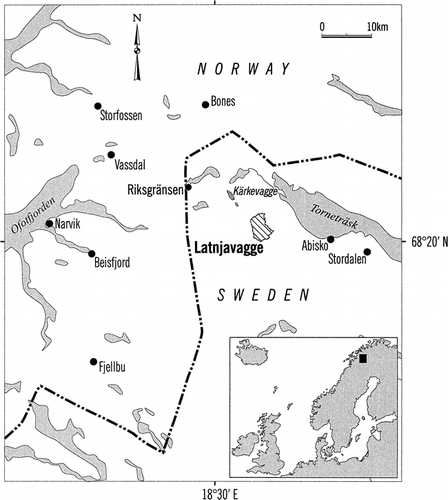
FIGURE 2. Investigation areas and instrumentation in the Latnjavagge drainage basin
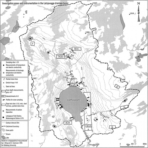
FIGURE 3. Daily radiation, wind speeds, air and ground temperatures, precipitation, and specific runoffs: (a) 2000 field season, (b) 2001 field season, (c) 2002 field season
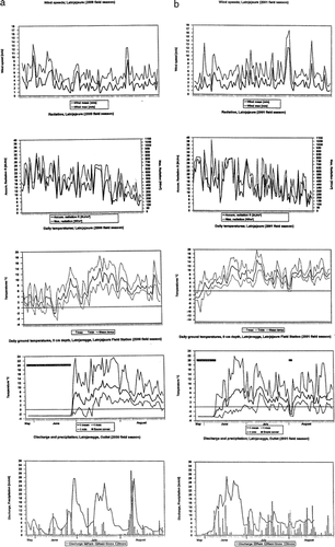
FIGURE 3. (Cont.)
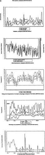
FIGURE 4. Daily specific runoffs, concentrations, and gross yields of dissolved solids; Outlet Latnjavagge, outlet lake and inlet lake Latnjajaure: (a) 2000 field season, (b) 2001 field season
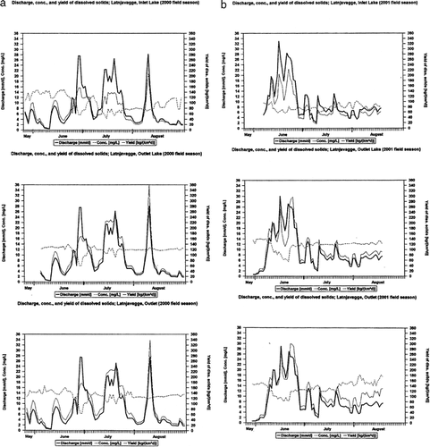
FIGURE 5. Daily specific runoffs, concentrations, and yields of suspended sediments; Outlet Latnjavagge, outlet lake and inlet lake Latnjajaure: (a) 2000 field season, (b) 2001 field season
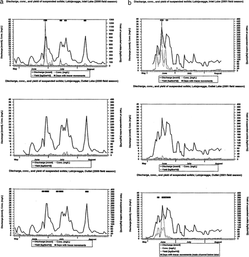
TABLE 1 Atmospheric salt inputs 1999/2000, 2000/2001, and 2001/2002, Latnjavagge drainage basin, northern Swedish Lapland
TABLE 2 Water chemistry data, Latnjavagge drainage basin, Swedish Lapland (sampling 2001)
TABLE 3 Yields of suspended and dissolved solids, Latnjavagge drainage basin (2000, 2001, and 2002 field seasons)
TABLE 4 Slush flows and transported masses. Latnjavagge drainage basin (2000, 2001, and 2002 field seasons)
Acknowledgments
Research was carried out during a postdoctoral grant to Achim A. Beylich given by Deutscher Akademischer Austauschdienst (DAAD), Bonn: Post-Doc-Programm, HSP III (Stipendium des DAAD im Rahmen des Gemeinsamen Hochschulsonderprogramms III von Bund und Ländern, 1999–2001). Since 2002 research has been funded by the Deutsche Forschungsgemeinschaft (Emmy Noether-Programm of DFG, Bonn, grant to Achim A. Beylich). Fieldwork was logistically supported by the Abisko Scientific Research Station (ANS), Latnjajaure Field Station (LFS), and by the Department of Earth Sciences, Uppsala University. The field assistants Thomas Giesecke and Sonia Fontana (both Department of Earth Sciences, Uppsala) gave helpful support in the field. Water chemistry analyses were carried out in the laboratory of FU Berlin, FB Earth Sciences, Institute for Geological Sciences, AB Hydrogeology. The support from the mentioned persons and institutions is gratefully acknowledged. We thank the two anonymous reviewers and the Editor of AAAR for their critical and helpful comments on the manuscript.
Related Research Data
References Cited
- Ahnert, F. 1986. The magnitude-frequency index—an approach to the identification of hygric morphoclimates. Zeitschrift für Geomorphologie, Supplementband 60:1–6.
- Ahnert, F. 1987. An approach to the identification of morphoclimates. In Gardiner, V. (ed.), International Geomorphology 1986, Part II. Chichester: Wiley, 159–188.
- André, M-F. 1995. Postglacial micro weathering of granite roches moutonnees in Northern Scandinavia. In Slaymaker, O. (ed.), Steepland Geomorphology. London: Wiley, 103–127.
- Barsch, D. 1984. Geomorphologische Untersuchungen zum periglazialen Milieu polarer Geosysteme. Zeitschrift für Geomorphologie, Supplementband 50:107–116.
- Barsch, D. 1986. Forschungen in Polargebieten. Heidelberger Geowissenschaftliche Abhandlungen 6:33–50.
- Barsch, D. 1993. Periglacial geomorphology in the 21st century. Geomorphology 7:141–163.
- Barsch, D. , M. Gude , R. Mäusbacher , G. Schukraft , and A. Schulte . 1992. Untersuchungen zur aktuellen fluvialen Dynamik im Bereich des Liefdefjorden in NW-Spitzbergen. Stuttgarter Geographische Studien 117:217–252.
- Barsch, D. , M. Gude , R. Mäusbacher , G. Schukraft , and A. Schulte . 1994. Recent fluvial sediment budgets in glacial and periglacial environments, NW Spitsbergen. Zeitschrift für Geomorphologie, Supplementband 97:111–122.
- Beylich, A. A. 1999. Hangdenudation und fluviale Prozesse in einem subarktisch-ozeanisch geprägten, permafrostfreien Periglazialgebiet mit pleistozäner Vergletscherung-Prozessgeomorphologische Untersuchungen im Bergland der Austfirdir (Austdalur, Ost-Island). Berichte aus der Geowissenschaft. Aachen: Shaker. 130 pp.
- Beylich, A. A. 2000a. Geomorphology, sediment budget, and relief development in Austdalur, Austfirdir, East Iceland. Arctic, Antarctic, and Alpine Research 32:466–477.
- Beylich, A. A. 2000b. Morphoklima und rezente Morphodynamik im periglazialen Bergland der Austfirdir (Austdalur, Ost-Island). Zeitschrift für Geomorphologie, Supplementband 123:57–78.
- Beylich, A. A. 2001. Slope denudation, stream work and relief development in two periglacial environments in East Iceland and Swedish Lapland. Transactions, Japanese Geomorphological Union 22:4 C-23.
- Beylich, A. A. 2002. Sediment budgets and relief development in present periglacial environments—a morphosystem analytical approach. Hallesches Jahrbuch für Geowissenschaften, A 24:111–126.
- Beylich, A. A. 2003. Present morphoclimates and morphodynamics in Latnjavagge, the northern Swedish Lapland and Austdalur, east Iceland. Jökull 52:33–54.
- Beylich, A. A. and D. Gintz . 2004. Characteristics of high-magnitude/low-frequency fluvial events generated by intense snowmelt or heavy rainfall in arctic periglacial environments in northern Swedish Lapland and northern Siberia. Geografiska Annaler 86A:11–29.
- Beylich, A. A. , E. Kolstrup , N. Linde , L. B. Pedersen , T. Thyrsted , D. Gintz , and L. Dynesius . 2003. Assessment of chemical denudation rates using hydrological measurements, water chemistry analysis and electromagnetic geophysical data. Permafrost and Periglacial Processes 14:387–397.
- Beylich, A. A. , E. Kolstrup , T. Thyrsted , and D. Gintz . 2004a. Water chemistry and its diversity in relation to local factors in the Latnjavagge drainage basin, arctic-oceanic Swedish Lapland. Geomorphology 58:125–143.
- Beylich, A. A. , E. Kolstrup , T. Thyrsted , N. Linde , L. B. Pedersen , and L. Dynesius . 2004b. Chemical denudation in arctic-alpine Latnjavagge (Swedish Lapland) in relation to regolith as assessed by radio magnetotelluric-geophysical profiles. Geomorphology 57:303–319.
- Beylich, A. A. , K. Lindblad , and U. Molau . 2005. Direct human impacts on mechanical denudation in an arctic-oceanic periglacial environment in northern Swedish Lapland (Abisko mountain area). Zeitschrift für Geomorphologie, Supplementband, 138: 81–100.
- Brunsden, D. 1996. Geomorphological events and landforms change. Zeitschrift für Geomorphologie 40:273–288.
- Caine, N. 1979. Rock weathering rates at the soil surface in an alpine environment. Catena 6:131–144.
- Caine, N. 1995. Temporal trends in the quality of stream water in an alpine environment: Green Lakes Valley, Colorado Front Range, U.S.A. Geografiska Annaler 77A:207–220.
- Caine, N. and E. M. Thurman . 1990. Temporal and spatial variations in the solute content of an alpine stream, Colorado Front Range. Geomorphology 4:55–72.
- Campbell, S. W. , J. C. Dixon , R. G. Darmody , and C. E. Thorn . 2001. Spatial variation of early season surface water chemistry in Kärkevagge, Swedish Lapland. Geografiska Annaler 83A:169–178.
- Campbell, S. W. , J. C. Dixon , C. E. Thorn , and R. G. Darmody . 2002. Chemical denudation rates in Kärkevagge, Swedish Lapland. Geografiska Annaler 84A:179–185.
- Clark, M. J. 1988. Periglacial Hydrology. In Clark, M. J. (ed.), Advances in Periglacial Geomorphology. Chichester: Wiley, 415–462.
- Collins, D. N. and G. J. Young . 1981. Melt water hydrology and hydrochemistry in snow- and ice covered mountain catchments. Nordic Hydrology 12:319–334.
- Darmody, R. G. , C. E. Thorn , R. L. Harder , J. P L. Schlyter , and J. C. Dixon . 2000. Weathering implications of water chemistry in an Arctic-Alpine environment, northern Sweden. Geomorphology 34:89–100.
- Darmody, R. G. , C. E. Allen , C. E. Thorn , and J. C. Dixon . 2001. The poisonous rocks of Kärkevagge. Geomorphology 41:53–62.
- Dixon, J. C. , C. E. Thorn , and R. G. Darmody . 1984. Chemical weathering processes on the Vantage Peak Nunatak, Juneau Icefield, southern Alaska. Physical Geography 5:111–131.
- Dixon, J. C. , R. G. Darmody , P. Schlyter , and C. E. Thorn . 1995. Preliminary investigation of geochemical process responses to potential environmental change in Kärkevagge, Northern Scandinavia. Geografiska Annaler 77A:259–267.
- Gintz, D. and K-H. Schmidt . 1991. Grobgeschiebetransport in einem Gebirgsbach als Funktion von Gerinnebettform und Geschiebemorphometrie. Zeitschrift für Geomorphologie, Supplementband 89:63–72.
- Gintz, D. and K-H. Schmidt . 1998. Sedimenttransport in einem arktischen Einzugsgebiet in Nordsibirien. Hallesches Jahrbuch für Geowissenschaften, A 20:93–106.
- Gintz, D. and K-H. Schmidt . 2000. Zeitliche und räumliche Variabilität der Sedimentbereitstellung und des Sedimenttransportes im Einzugsgebiet des Levinson-Lessing-Sees (Nordsibirien). Zeitschrift für Geomorphologie, Supplementband 121:123–138.
- Gude, M. , R. Mäusbacher , G. Schukraft , and A. Schulte . 1996. Untersuchung hydrologischer und hydrochemischer Prozesse in hocharktischen Permafrost-Einzugsgebieten mit Hilfe natürlicher Tracer. Heidelberger Geographische Arbeiten 104:460–472.
- Gude, M. and D. Scherer . 1999. Atmospheric triggering and geomorphic significance of fluvial events in high-latitude regions. Zeitschrift für Geomorphologie, Supplementband 115:87–111.
- Johannessen, M. and A. Henriksen . 1978. Chemistry of snow melt water: changes in concentration during melting. Water Resources Research 14:615–619.
- Jonasson, C. 1991. Holocene slope processes of periglacial mountain areas in Scandinavia and Poland. UNGI Rapport 79. Uppsala University.
- Jonasson, C. and R. Nyberg . 1999. The rainstorm of August 1998 in the Abisko area, northern Sweden: preliminary report on observations of erosion and sediment transport. Geografiska Annaler 81A:387–390.
- Kling, J. 1996. Sorted circles and polygons in northern Sweden, Distribution and Processes. Ph.D. thesis. Department of Physical Geography, Göteborg University.
- Kling, J. 2005. January 2005. www.systbot.gu.se/research/latnja/site.html .
- Kulling, O. 1964. Översikt över Norra Norrbottensfjällens Kaledonberggrund. Sveriges Geologiska Undersökning: Serie Ba Översiktskartor med beskrivningar 19:166.
- Leser, H. , K. Dettwiler , and Ch Döbeli . 1992. Geoökosystemforschung in der Elementarlandschaft des Kvikaa-Einzugsgebietes (Liefdefjorden, Nordwestspitzbergen). Stuttgarter Geographische Studien 117:105–122.
- Molau, U. 2001. Tundra plant responses to experimental and natural temperature changes. Memoirs of National Institute of Polar Research, Special Issue 54:445–466.
- Molau, U. 2005. January 2005. www.systbot.gu.se/research/latnja/site.html .
- Molau, U. , J. Kling , K. Lindblad , R. Björk , J. Dänhardt , and A. Liess . 2003. A GIS assessment of alpine biodiversity at a range of scales. In: Nagy, L., Grabherr, G., Körner, C., and Thompson, D. B. A. (eds.), Alpine Biodiversity in Europe. Ecological Studies, 167. Berlin, Heidelberg: Springer, 221–229.
- Nyberg, R. 1985. Debris flows and slush avalanches in northern Swedish Lapland. Medd. Lunds Universit. Geograf. Inst., Avhandling, XCVII. 222 pp.
- Potschin, M. and H. Leser . 1994. Saisonaler Verlauf des Vorfluterchemismus im Kvikaa-Einzugsgebiet (Liefdefjorden, NW-Spitzbergen). Zeitschrift für Geomorphologie, Supplementband 97:161–174.
- Peltier, L. C. 1950. The geographic cycle in periglacial regions as it is related to climatic geomorphology. Annals of the Association of American Geographers 40:214–236.
- Rapp, A. 1960. Recent development of mountain slopes in Kärkevagge and surroundings, northern Scandinavia. Geografiska Annaler 42:71–200.
- Rapp, A. 1995. Case studies of geoprocesses and environmental change in mountains of northern Sweden. Geografiska Annaler 77A:189–198.
- Reynolds Jr., R. C. and N. M. Johnson . 1972. Chemical weathering in the temperate glacial environment of the Northern Cascade Mountains. Geochimica et Cosmochimica Acta 36:537–554.
- Scherer, D. and E. Parlow . 1996. Meteorology and hydrology of slush stream initiation in a changing climate. In Sand, K. and Killingtveit, Å (eds.), Proceedings of the 10th International Northern Research Basin Symposium and Workshop, Spitzbergen 1994: 346–358.
- Schlyter, P. , P. Jönsson , R. Nyberg , P. Persson , A. Rapp , C. Jonasson , and J. Rehn . 1993. Geomorphic process studies related to climate change in Kärkevagge, northern Sweden—status of current research. Geografiska Annaler 75A:55–60.
- Strömquist, L. and J. Rehn . 1981. Rainfall measurements, runoff and sediment transport in Kärkevagge, Swedish Lapland. Transactions, Japanese Geomorphological Union 2:211–222.
- Thorn, C. E. 1975. Influences of late-lying snow on rock weathering rinds. Arctic and Alpine Research 7:373–378.
- Thorn, C. E. , R. G. Darmody , J. C. Dixon , and P. Schlyter . 2001. The chemical weathering regime of Kärkevagge, arctic-alpine Sweden. Geomorphology 41:37–52.
- Von Lozinski, W. 1909. Über die mechanische Verwitterung der Sandsteine im gemässigten Klima. Bulletin International de L'Academie des Sciences de Cracovie class des Sciences Mathematique et Naturalles 1:1–25.
- Von Lozinski, W. 1912. Die periglaziale Fazies der mechanischen Verwitterung. Comptes rendus, XI Congres Internationale Geologie, Stockholm 1910:1039–1053.
- Walling, D. E. and B. W. Webb . 1983. The dissolved load of rivers: a global overview. In Webb, D. E. (ed.), Dissolved Loads of Rivers and Surface Water Quality/Quantity Relationships. International Association of Hydrological Sciences Publication No. 141: 3–20.