Abstract
Glacial mapping combined with cosmogenic exposure dating provides the first detailed assessment of the late Pleistocene glacial history in the northeastern Brooks Range, Alaska. Former ice limits were identified in the Okpilak, Jago, Aichillik, Egaksrak, and Kongakut River valleys. Relative-weathering data support our correlations with the well-studied glacial sequence of the central Brooks Range. Of the 16 boulders from four moraines analyzed for 10Be, the exposure ages on two moraines are tightly clustered. The results indicate that the glacier in the Jago River valley reached its maximum extent during the Itkillik II glaciation by about 23.2 ± 2.8 ka. The ice retreated rapidly, and a prominent, but local, readvance took place by 19.1 ± 2.8 ka within a tributary valley. The relative size of glaciers and the difference in ice extent between the Itkillik I and Itkillik II glaciations varied among the river valleys, with the Aichillik River valley showing the greatest difference. A first-order trend surface fit to Itkillik II equilibrium lines rises toward the south, from 1400 to 1800 m. This is a reversal of the overall trend across the rest of the Brooks Range, and suggests that glaciers of the last glacial maximum in the northeastern sector, similar to today, benefited from the cold and possibly moister conditions associated with their proximity to the Beaufort Sea.
Introduction
Aside from the Cordilleran Ice Sheet, the largest center of glaciation in Alaska was the Brooks Range, where subpolar mountain glaciers shaped the alpine landscape over repeated cycles of Pleistocene glaciation. Much of the Brooks Range exhibits well-expressed glacial features that have been mapped previously and show evidence for multiple phases of glaciation. In contrast, the evidence for glaciation in the northeastern Brooks Range is not well-expressed geomorphically, nor has this section of the range been previously studied in detail similar to other parts of the Brooks Range.
This study focuses on the late Pleistocene glacial history of the Okpilak-Kongakut Rivers region, northeastern Brooks Range (), located at the eastern fringe of the extensive mountain glaciation of northern Alaska. The goal is to identify the limits of late Pleistocene glaciers and to interpret the ages of glacial landforms within the five major river valleys that drain the northeastern sector of the range. Age estimates are based on relative-weathering features of moraines and comparisons to previously dated glacial sequences in the central Brooks Range. In addition, we analyzed cosmogenic 10Be in surface boulders of four moraines to derive exposure ages. Equilibrium-line altitudes (ELAs) are reconstructed to correlate among similar-age moraines and to examine their spatial variation. The results from this study are incorporated into the range-wide reconstruction of ELAs for the last glacial maximum, which will be presented in a subsequent paper (Balascio et al., in press). In addition, the glacial mapping for the northeastern Brooks Range has been integrated into the Alaska Paleoglacier Atlas (CitationManley and Kaufman, 2002; CitationKaufman and Manley, 2004), a statewide compilation of Pleistocene glacier extents in digital format.
SETTING
As the northernmost extension of the Rocky Mountains, the Brooks Range spans ∼1000 km east to west across northern Alaska from the Alaska-Yukon border to the Chukchi Sea (). Summit elevations generally increase eastward, exceeding 2700 m in the northeast where the range is within 80 km of the Beaufort Sea. The eastern part of the range is structurally unique, and is separated from the central Brooks Range by the Canning Displacement Zone (CitationGrantz et al., 1994). Regional deformation is youngest east of this zone, and it has extended farther north relative to the rest of the range. Modern glaciers are most numerous in the central Brooks Range where they occupy the highest north-facing cirques. The largest glaciers, up to 10 km long, are in the eastern Brooks Range around Mount Chamberlin and Mount Michelson where the range reaches its peak elevations.
The dominant source of moisture feeding Pleistocene and modern glaciers is from the southwest (CitationPéwé, 1975; CitationPorter et al., 1983). Reconstructed glaciation thresholds across the range show a prominent lowering in this direction. Although the moisture transport direction was similar to the modern pattern, moisture traveled farther to reach the Brooks Range during full-glacial conditions because of the emergence of the broad Bering and Chukchi continental shelves as a result of eustatic sea-level lowering.
Pleistocene glaciers covered most of the central and eastern Brooks Range, and parts of the De Long and Baird Mountains in the west (CitationPorter et al., 1983; CitationHamilton, 1986). Glaciers grew at lower elevations in the western Brooks Range and along its southern flank relative to glaciers farther east and on the north side of the range. Confluent ice forming large transection glaciers (an interconnected system of low-lying valley glaciers with poorly defined ice divides) occupied most of the major river valleys in the central and eastern Brooks Range where elevations are highest.
The study area in the northeastern Brooks Range encompasses the transition from nearly continuous ice cover in the west to isolated valley and cirque glaciers in the east. The area is bounded by the Okpilak River in the west and by the Kongakut River to the south and east (). These river valleys, as well as the intervening Jago, Aichillik, and Egaksrak River valleys, all drain the northern mountain front toward the Beaufort Sea and contain evidence for late Pleistocene glaciers. Modern glaciers persist in the western portion of the study area at ∼2000 m where elevations reach up to ∼2700 m and ∼50% of the area is above 1600 m. East of the Jago River elevation decreases, with only ∼10% of the area above 1600 m.
The bedrock geology of this 5500 km2 area is diverse and includes plutonic, sedimentary, and metasedimentary rocks (CitationSable, 1977). Most relevant to this study is the Okpilak batholith and the Jago stock that underlie the headwaters of the Okpilak and Jago Rivers in the western portion of the study area. Glacially transported quartz monzonite and granitic rocks eroded from these two drainage basins comprise resistant boulders on lateral and end moraines in these valleys. These plutons provide durable, quartz-rich erratic boulders to sample for exposure dating.
PREVIOUS WORK
Previous glacial mapping has focused on the central Brooks Range (e.g., CitationHamilton and Porter, 1975; CitationHamilton, 1986), with nearly complete 1:250,000-scale map coverage (summarized by CitationHamilton, 1994). In contrast, glacial mapping of the entire eastern Brooks Range, east of 147°W longitude, has received less research attention. Recent statewide compilations of glacial geology (CitationHamilton, 1986, Citation1994) do not mention the eastern Brooks Range. Previous mapping of Pleistocene glacial features in the northeastern Brooks Range is restricted to compilations by CitationCoulter et al. (1965) at a scale of 1:2,500,000; a few local studies near Mount Chamberlin (CitationHolmes and Lewis, 1965), Lake Peters (CitationReed, 1968), and the western Romanzof Mountains (CitationSable, 1977); and most recently a geologic map by CitationReiser et al. (1980) at a scale of 1:250:000, and an engineering geology map by CitationCarter et al. (1986). CitationReiser et al. (1980) focused on the bedrock geology, although they mapped and inferred relative ages of Pleistocene deposits in most areas; CitationCarter et al. (1986) mapped the Arctic Coastal Plain and the foothills. Neither of these publications attempted correlations with the glacial sequence previously documented in the central Brooks Range, and deposits related to valley glaciers that terminated within the confines of the range were mapped by CitationReiser et al. (1980) in only four tributary valleys, whereas we document moraines in ten valleys; these provide the basis of our ELA analysis.
Of the four Pleistocene glaciations described previously for the Brooks Range (CitationHamilton, 1986), this study focuses on the most recent, the Itkillik glaciation. Evidence for the age and extent of the late Pleistocene Itkillik glaciation is summarized by CitationHamilton (1994) as follows: The glaciation is divided into the Itkillik I and Itkillik II phases, which are believed to be correlative with the early and late Wisconsin, respectively. Moraines of these two phases are commonly nested, and were originally grouped as representing one glacial phase until they were differentiated by CitationHamilton and Porter (1975). The Itkillik I glaciation includes two stages: a maximum stage when moraines were deposited up to 40 km north of the mountain front, followed by a readvance sometime between ∼55 and ∼75 ka. The age of this advance is beyond the effective range of 14C dating, but is known to have occurred after the last interglaciation, because Itkillik I deposits overlay the Old Crow tephra. During the Itkillik II glaciation, glaciers extended up to 25 km north of the range. The age of Itkillik II is bracketed between 24 and 15 14C ka based on the 14C age of wood fragments in lake beds upvalley from the end moraine deposited in the Noatak River valley in the western part of the range, as well as from numerous 14C ages on organic material from river alluvium and periglacial deposits. Its drift is characterized by irregular deposits that are steeper, stonier, and less vegetated than Itkillik I age drift. In addition, moraines have multiple crests and other primary constructional features with minor relief. A readvance took place late during the Itkillik II glaciation, between 13 and 11.5 ka (CitationHamilton, 2003). The advance left distinct moraines morphologically similar to deposits of the main Itkillik II glaciation. Glaciers extended up to 15–20 km north of the range front in some valleys and were less extensive in other valleys.
Methods
GLACIAL MAPPING
Our mapping of glacial features was guided by morphostratigraphic relations, relative-weathering characteristics of moraines, and reconstructed ELAs. We focused on glacial features of the last two major glaciations of the Pleistocene, Itkillik I and Itkillik II, although younger and older moraines were observed in air photos and in the field. Late Pleistocene moraines and other glacial features were delimited on 1:63,360-scale topographic maps using aerial photographs. Aerial photograph interpretations of glacial features were field-checked and refined where possible. The relative extent of former glaciers within the study area was used to guide correlations of moraines among valleys, but limits of former glaciers in some valleys remain poorly defined.
RELATIVE WEATHERING
Relative-weathering characteristics of moraines were measured to quantify the morphometry of different-age glacial deposits. The results aid in correlating moraines among valleys in the northeastern Brooks Range and with previously dated moraines in the central Brooks Range. Moraine morphometry and soil formation were the primary relative-age criteria. These criteria have been shown to distinguish younger moraines as having steeper slopes and sharper crests, and more poorly developed soil (e.g., CitationHamilton, 1986). Rock-weathering features were also studied, but the data proved to be inclusive because of the variable lithologies across the study area (CitationBalascio, 2003). Sites for relative-weathering measurements were chosen along moraines where slopes were the steepest and where postdepositional modification of the moraine surface was judged to be minimal. All criteria were measured at each site, with two or three sites along each moraine crest. In all, data were collected from 13 moraines.
Morphometric analysis included measurements of moraine slope angles, slope heights, and crest widths following the methods of CitationKaufman and Calkin (1988). A single crest width was recorded, and between four and six slope angles and associated slope heights were averaged per site. One test pit per site was dug on the moraine crest to assess the general degree of soil formation. The maximum depth of oxidation, marked by a slight change in color at the base of the B horizon, was recorded.
EQUILIBRIUM-LINE ALTITUDES
The ELA separates the zone of accumulation from the zone of ablation on a glacier, and is controlled mostly by summer temperature and winter snow accumulation. For modern glaciers, the ELA is determined based on yearly mass balance measurements; for Pleistocene glaciers, the ELA is estimated by applying empirical relationships to the reconstructed ice extent based on geomorphic evidence. ELAs can guide correlations among similar-age glaciers reconstructed in nearby valleys. Glaciers in a particular area are subject to similar climatic conditions and should have relatively similar ELAs. Although ELAs vary across a region, generally rising away from a moisture source, these regional trends are usually less pronounced than the differences between ELAs of separate glaciations. We focused on the ELAs for glaciers reconstructed from moraines inferred to be Itkillik II in age. We assumed that the spatial pattern of the ELAs was relatively uniform within the study area and used this pattern to evaluate the physiographic congruency of our glacial-geologic mapping.
Methods applied to reconstruct the ELA of former glaciers have been reviewed previously (e.g., CitationPorter, 2001). The accumulation area ratio (AAR) method, which assumes a fixed ratio between the accumulation and ablation zones, was found to be reliable. Previous authors have assumed ratios ranging from 0.5 to 0.8, although most use 0.60–0.65. We used a recently derived AAR of 0.58, which is based on a global analysis of average AARs for steady-state mass balance of modern glaciers (Dyurgerov, personal communication; cf. CitationDyurgerov, 2002), and assessed sensitivity to a range of possible AAR ratios.
ELAs were reconstructed by interpreting and mapping glacier outlines from ice-marginal features including moraines and trimlines. ELAs were only calculated for isolated valley glaciers, where the accumulation areas are easily delineated. Large glaciers fed by ice from numerous sources were not used in this analysis. Glacier outlines were then digitized into ArcGIS and their former surfaces interpolated digitally. MFWorks, another GIS software package, was used to derive ELAs by calculating the percent area at 3-m-elevation increments along each glacier's surface to determine the altitude separating the upper 58% of the glacier from the lower 42%. The geospatial methods for estimation of ELAs, and results across the Brooks Range, will be described in greater detail in a subsequent paper. Similar geospatial analyses of glaciers, including derivation of surface hypsometry, are presented in CitationManley (in press).
EXPOSURE AGES
Assigning ages to glacial deposits in alpine environments is challenging because material datable by 14C is rare. We relied on the cosmogenic isotope 10Be to derive exposure ages for quartz-bearing erratic boulders from moraines of the Jago and Okpilak River valleys. The sampling, analytical, and data-interpretation procedures used to derive the ages are presented in CitationBriner et al. (2005).
Glacial Geology
PRE-ITKILLIK GLACIATION
Prior to the late Pleistocene, glaciers originating in the northeastern Brooks Range reached far north of the mountain front. CitationReiser et al. (1980) mapped undifferentiated moraine and glacial fluvial deposits up to ∼60 km beyond the mountain front in the Demarcation Point quadrangle. CitationCarter et al.'s (1986) oldest glacial drift comprises a few isolated patches on the coastal plain near the Jago and Kongakut Rivers. CitationSable (1977) found evidence for early Pleistocene ice beyond the Okpilak and Jago River valleys. The oldest advance recognized by CitationSable (1977) is represented by scattered patches of drift ∼20 km north of the range front that lack morainal form and are marked by well-integrated drainages and few extensively weathered erratics. Drift of this age was inferred to have been deposited by a system of coalesced piedmont glaciers, and was correlated with either the Anaktuvuk River or Sagavanirktok River glaciations. Farther east, our interpretation of aerial photographs suggests that ice never crossed the Alaska/Yukon border. CitationVincent (1989) and Hamilton (written communication, 2004) came to the same conclusion. In contrast, the limit of early to middle Pleistocene glaciers mapped by CitationCoulter et al. (1965) continues east into northwestern Canada, perhaps because they misinterpreted the glacial-marine deposits exposed in coastal bluffs as having been deposited by terrestrial-based glaciers.
We found evidence for a pre-Itkillik advance in only one valley in the study area. In the Egaksrak River valley, a moraine located 7 km south of the mountain front is marked by a broad crest (∼100 m), and gentle topography with average slope angles of 6°, a thick vegetation cover, and a boulder-free surface. Moraines that exhibit a similar degree of weathering are assigned to the middle-Pleistocene Sagavanirktok River glaciation in the central Brooks Range (CitationHamilton, 1986) ().
ITKILLIK I GLACIATION
We identified a twofold moraine sequence in each of the five mountain valleys that we studied. The moraines built out onto the coastal plain beyond the Okpilak and Jago River valleys in the western part of the field area comprise a nested sequence of bulky moraines up to 200 m above their respective river channels whereas, in trunk valleys to the east, the moraines are largely confined within the mountain valleys. The twofold drift sequence that we delimited beyond the Okpilak and Jago River valleys roughly corresponds with the “Qg2” (older) and “Qg3” (younger) drift units mapped by CitationReiser et al. (1980). This interpretation differs slightly from the one presented by CitationBalascio (2003). We did not study the older drift associated with these two valleys in the field, and our relative-weathering data from the outer-moraine suite is based on data from the Egaksrak River valley only (). Aerial photographs show that the moraines of CitationReiser et al.'s (1980) Qg2 unit and the outer moraines in other valleys in the field area are marked by smooth, broad hummocks with few boulders. On this basis, together with the morphostratigraphic position of the drift, we tentatively correlate the older moraines of the twofold sequence in each of the five river valleys with the Itkillik I glaciation of the central Brooks Range. Accepting this correlation, a range-wide picture emerges, with ice filling all of the major river valleys and progressively decreasing in extent to the east.
A small glacial trough, informally named “Middle Valley,” located on the north flank of the range between the Okpilak and Jago River valleys, contained an isolated glacier during the late Pleistocene. The Middle Valley exhibits a prominent sequence of moraine ridges (). The outer ridge, interpreted to be Itkillik I in age, is ∼8 km downvalley from the cirque headwall and is confined by the valley walls. No other moraine ridges were seen farther downvalley from this outer ridge, which appears on aerial photographs to be less pronounced than the inner ridges.
Our mapping of glacial deposits in the trunk and tributary valleys of the Kongakut River valley is uncertain. The moraine that we ascribe to the Itkillik I glaciation in the Kongakut River valley is marked by numerous circular depressions, some with small lakes, and subdued ridges comprising a hummocky landscape underlain by drift. This moraine appears to delimit the extent of late Pleistocene ice, as the valley constricts downvalley to one shaped by fluvial erosion. Itkillik I and Itkillik II deposits in small tributary valleys of the Kongakut River valley may be tightly nested, making them difficult to distinguish.
ITKILLIK II GLACIATION
The inner moraine that we mapped in front of the Jago and Okpilak River valleys roughly coincides with CitationReiser et al.'s (1980) younger drift (Qg3), as do the inner moraines that we mapped at the headwaters of the Egaksrak and Kongakut River valleys. These moraines are characterized by sharp crests flanked by steep slopes, with average slope angles ranging from 14° to 21°, crest widths of 18–43 m, and soil oxidation depths of 15–42 cm (). In the eastern valleys, the moraines enclose tributary valleys that head in steep cirques that exhibit little postglacial modification. Considering the relatively minor weathering and the morphostratigraphic position, we correlate these moraines with the Itkillik II glaciation as described in the central Brooks Range. Itkillik II moraines have a similar range of slope angles and comparable soil oxidation depth, although crest widths are wider in the northeastern Brooks Range ().
The extent of glaciers during the Itkillik II glaciation varied greatly among the major river valleys. In the Jago and Okpilak River valleys, Itkillik II ice extended ∼12 km beyond the mountain front, but in the adjacent Aichillik River valley, as well as the Egaksrak and Kongakut River valleys to the east, glaciers were generally less than 6 km long; they occupied first-order valleys fed by only a few cirques. The former location of these small valley glaciers was inferred by well-developed cirques with steep headwalls and flat cirque floors, usually associated with summit elevations exceeding 2000 m (). Moraines of the Itkillik II glaciation in the Egaksrak River valley were also distinguished by abundant surface boulders on moraines that are absent on the older Itkillik I moraine farther downvalley.
Of the four valleys east of the Jago River valley, the Aichillik River valley contained the least amount of ice, despite higher elevations of the uplands. In addition, the evidence for glaciation in the Aichillik River valley is poorly expressed (). Glacial erosional and depositional features in this drainage are immature, with poorly developed cirques and a lack of drift in the main trunk valley. Itkillik II moraines were not found downvalley of the few extant glaciers in the drainage, which cling to the sides of steep mountain peaks. The lack of evidence for late Wisconsin glaciation in a drainage basin that today contains glaciers is unexpected. The former limits of these glaciers were mapped with some uncertainty, and glaciers may have advanced farther during the Itkillik II phase than illustrated in this paper. However, the moraine mapped in the Aichillik River valley, where the river debouches onto the coastal plain, must be at least as old as Itkillik I, if not older. Because its topography is more subdued than expected for the Itkillik II glaciation, we correlated it to Itkillik I moraines in the Jago and Okpilak River valleys (although the moraine was not visited in the field). CitationReiser et al. (1980) also correlated this moraine with the older drift unit (Qg2), whereas CitationCarter et al. (1986) assigned it to an even older relative age (Qgd1). The only Itkillik II moraine that we mapped with confidence within the Aichillik River valley drainage basin was deposited at the mouth of the Leffingwell River valley. This moraine, clearly visible in aerial photographs and studied in the field, is similar to other Itkillik II moraines elsewhere in the study area.
LATE ITKILLIK II GLACIATION
One prominent moraine in the Jago River valley is younger than the maximum phase of the Itkillik II glaciation. This prominent moraine was not identified on previous maps. It is located ∼15 km up-valley from the Itkillik II limit and encircles the mouth of the valley that drains the Hubley Glacier (). This moraine, hereafter referred to as the “Hubley moraine,” is distinctly hummocky and arcuately shaped, with average slopes of 19–25°, crest widths of 17–26 m, and soil oxidation depths from 13 to 16 cm. In comparison to moraines of the maximum Itkillik II glaciation, the Hubley moraine has steeper slopes, sharper crest widths, and shallower soil oxidation depths. Late Itkillik II moraines in the central Brooks Range are also generally steeper and sharper than older deposits. Glacier limits of similar extent were not found anywhere else in the field area.
Geochronology
Samples for 10Be analysis were collected from 16 boulders on the sequence of three moraines in the Jago River valley and on one moraine in the Okpilak River valley (). These are the only numerical ages presently available in the study area. The ages of multiple boulders from two of the four moraines are tightly clustered (within ∼10% of one another), indicative of similar exposure histories (; ). In contrast, 10Be analyses of multiple boulders from the other two moraines yielded widely scattered apparent ages (varying by ∼50%). The results from these boulders do not provide reliable age control for moraine formation. Possible explanations for these aberrant results, and similar results from moraines elsewhere in Alaska, are discussed by CitationBriner et al. (2005).
Of the five samples from the broad left lateral moraine of the Jago River valley, four yielded exposure ages that are tightly clustered (). We rejected one age because it was twice as old as the others, possibly because it was influenced by isotopic inheritance from prior exposure. The average exposure age of the four boulders is 23.2 ± 2.8 ka (), which is consistent with limiting ages for the Itkillik II glaciation determined in the central Brooks Range (CitationHamilton, 1986), and with late Wisconsin advances elsewhere in the state (CitationKaufman and Manley, 2004).
The single older (55.7 ka) exposure age from the broad left lateral moraine of the Jago River valley is within the range of the 10Be ages from an apparently correlative moraine in the Okpilak River valley. The exposure ages of the three boulders from the high left lateral moraine of the Okpilak River valley range from 27 to 76 ka, possibly indicating progressive exhumation of an early Wisconsin landform. Because the moraines are composite features formed over multiple glaciations, the boulders might have been deposited during both the Itkillik I and II glaciations. Regardless of the cause of the scatter, we interpret the tightly grouped ages from the lateral moraine in the Jago River valley, and the correlative moraine in the Okpilak River valley, as dating the most recent advance of glacier ice (Itkillik II) beyond the mountain front, a conclusion supported by the mapping of CitationReiser et al. (1980).
The 10Be ages of four moraine boulders from an end moraine located along the bottom of the Jago River valley range from 42.3 to 9.2 ka and average 22.8 ± 15.1 ka. This moraine is morphostratigraphically younger than the high lateral moraine of the Jago River valley, but the scatter in the age precludes more specific interpretations, other than the moraine is no older than the late Wisconsin.
The ages of four boulders from the Hubley moraine form a tight group, averaging 19.1 ± 2.8 ka (; ). This age overlaps with the age of the lateral moraine, 61 m higher and 14 km farther downvalley in the Jago River valley. It assigns the moraine to the main Itkillik II advance, rather than to the readvance that occurred during the latest Itkillik II glaciation. If the ages are too old and the moraine does correlate with the late Itkillik II glaciation, then the boulders contain a uniform amount of inherited cosmogenic isotopes, which seems unlikely. Instead, the moraine might correlate with the younger of the three nested moraines that formed during the Itkillik II glaciation recently described from the Kurparuk River drainage in the central Brooks Range (CitationHamilton, 2003).
Assuming that the mean exposure ages for the lateral moraine in the Jago River valley and the Hubley moraine accurately represent the timing of deposition, they imply that the two moraines differ in age by about 4000 yr. If so, then ice retreated rapidly from its maximum position, pulling back at least 22 km at an average rate exceeding 6 m yr−1 to a position upvalley of the Hubley moraine. The cause of such a rapid retreat during the peak of marine oxygen-isotope stage 2 is unclear, but is probably related to moisture availability. The glacier in the tributary valley of the Hubley Glacier then readvanced to deposit the Hubley moraine within the Jago River valley, which must have been ice-free at that elevation. Moraine evidence for a corresponding readvance of the glacier in the main stem of the Jago River valley, or for other glaciers in the northeastern Brooks Range, has not been identified.
Equilibrium-line Altitudes
SPATIAL PATTERNS
ELAs were reconstructed for 43 isolated valley glaciers in the Middle, Aichillik, Leffingwell, Egaksrak, and Kongakut River valleys, which are interpreted to be Itkillik II in age (). ELAs were not reconstructed for Itkillik II glaciers in the Jago and Okpilak River valleys, nor for any of the Itkillik I glaciers, because accumulation areas for these larger glaciers were complex and difficult to reconstruct. The ELA of the 15 former glaciers in the Middle and Aichillik River valleys averages 1719 ± 97 m. In comparison, the ELA of the 28 glaciers in the valleys to the east (the Leffingwell, Egaksrak, and Kongakut River valleys) averages 1533 ± 167 m. Together the 43 paleoglaciers yield an average ELA of 1598 ± 170 (± 1 σ). The average ELA is not particularly sensitive to a range of AAR values; by assuming ratios of 0.48 and 0.68, the average differs by only 53 m and 56 m, respectively. Similarly, the spatial pattern of ELAs is robust, independent of the specific AAR value used.
Trends in ELAs of reconstructed Itkillik II glaciers are shown across an east-west profile () and as a first-order trend surface (). In profile, the east-to-west distribution of ELAs exhibits a slight (0.4 m km−1) westward rise; the ELAs of reconstructed glaciers in the Aichillik and Middle River valleys are only ∼250 m below the median elevations of modern glaciers. The trend surface () dips northward at ∼8.9 m km−1. This distribution of ELAs is unexpected in the northeastern Brooks Range because they trend opposite that of the rest of the range (CitationPéwé, 1975; CitationPorter et al., 1983; CitationBalascio, 2003; CitationBalascio et al., in press). Glaciation thresholds and ELAs of Itkillik II glaciers rise toward the east and dip toward the southwest across the western and central Brooks Range.
The ELA trends in the northeastern Brooks Range are based mostly on glaciers reconstructed in the Aichillik River valley. The high ELAs in the western and southern part of the study area influence the westward and southward rise of the ELA trends. Despite uncertainty in mapping, the extent of glaciers in the Aichillik River valley is supported by the ELA of the Middle Valley glacier, and the ELA and relative extent of the Itkillik II glacier that terminated in the Leffingwell River valley. The simple and compact glacier in the Middle Valley was reconstructed with confidence and has an ELA that lies within the range of those in the Aichillik River valley (; ). The east-west profile highlights the ELA of the former glacier in the Leffingwell River valley relative to those of adjacent valleys. This glacier is delimited by a distinct looped-end moraine that was deposited within a valley that feeds the Aichillik River; it must therefore be younger than the moraine at the mouth of the Aichillik River valley downstream from the Leffingwell River, which has been ascribed by us and by previous workers to a pre-late Wisconsin glaciation. The interpretation of the age of this moraine is therefore consistent with the glacial mapping of the Aichillik River valley as relatively ice-free during the Itkillik II glaciation.
CONTROLS ON ELAs IN THE NORTHEASTERN BROOKS RANGE
The overall southward rise in ELAs reconstructed for the Iktillik II glaciation across the study area () can be interpreted in terms of paleoclimate forcing. In other settings, spatial patterns in both modern and paleo-ELAs generally reflect patterns in accumulation-season precipitation (e.g., CitationPorter, 2001). ELAs generally rise as moisture is transported away from sources. ELA variability in map view can also be affected by spatial differences in ablation-season temperature. In some areas of the world, post-glacial tectonic activity has also influenced ELA trends.
The higher ELAs in the southwestern part of the study area are not readily explained by differential tectonic uplift since the Itkillik II glaciation. This hypothesis was proposed by CitationPorter et al. (1983) to explain the unexpectedly small difference between modern and late Wisconsin glacial thresholds in the Mount Chamberlin area. Mesozoic to Cenozoic northward-verging thrusts have been recently active in the area (CitationWallace and Hanks, 1990; CitationO'Sullivan et al., 1993), deforming Quaternary sediments and causing historic earthquakes along the adjacent Arctic Ocean coast (CitationGrantz et al., 1994). However, propagation of the thrusts is northward toward faults mapped offshore (CitationPlafker et al., 1994), opposite the direction needed to explain higher ELAs in the south-southwest. Furthermore, a tectonic explanation for the north-northeast decrease in ELAs (∼200 m) would require unusually high rates of uplift (7–13 mm yr−1). Such rates are normally limited to active plate margins, and are not consistent with fission-track ages on bedrock exhumation in the northeast Brooks Range (CitationO'Sullivan et al., 1993). In addition, there is no geomorphic evidence of Quaternary uplift, such as fault scarps with Quaternary offset or river downcutting and terrace formation along the axial rivers.
The spatial pattern in ELAs is not clearly related to precipitation alone, as expected for ELA patterns at this scale. The northward lowering in Itkillik II ELAs could be explained by moisture transport from the north. As a modern analog, the Beaufort Sea is a source of precipitation for existing glaciers in the northeastern Brooks Range (CitationPorter et al., 1983; CitationEvison et al., 1996; CitationRabus and Echelmeyer, 1998). However, there is evidence for more extensive winter sea-ice cover during the Pleistocene (CitationPhillips and Grantz, 1997), which would have restricted the amount of open water available for moisture during the accumulation season.
Instead, the ELA pattern might be locally related to summer temperature where the Brooks Range is closest to a coastal maritime effect. Normally, the influence of temperature on ELAs is expressed at broad latitudinal scales. Also, typical lapse rates characterize how temperature normally increases as one descends from summit to lowland. However, modern summer temperature actually decreases northward from the crest of the northeastern Brooks Range. For example, July mean temperature decreases from 12°C at Atigun Pass to 4°C at Prudhoe Bay (CitationHaugen, 1979; see also the PRISM climate model, CitationDaly et al., 1994, Citation2002). This ablation-season effect exists within approximately 100 km of the Beaufort coast. If a similar coastal influence existed during the Itkillik II glaciation, where the Brooks Range is closest to the paleoshoreline, local variation in summer temperature could explain some or all of the unusual northward lowering of ELAs.
Conclusions
Our reconstruction of late Pleistocene glaciers in the northeastern Brooks Range contributes a more detailed record of ice extent than has previously been documented for the region. New relative-weathering data support our correlations with the well-studied glacial sequence in the central Brooks Range. Our 10Be ages on surface boulders from the Jago River valley suggest that Itkillik II glaciers reached and retreated from the northeastern Brooks Range front relatively early during the late Wisconsin, by about 23 ka. The Hubley moraine records a prominent readvance in the Jago River valley at about 19 ka.
Glacial-geologic mapping shows that, during both phases of the Itkillik glaciation, voluminous ice occupied the Okpilak and Jago River valleys, sourced in the high-elevation headwaters. East of these river valleys, differences in the extent of Itkillik I and Itkillik II advances are greater. From west to east, Itkillik I glaciers progressively decreased in extent from the Okpilak to the Kongakut River valleys. In contrast, glaciers during the Itkillik II phase were much smaller compared to their Itkillik I predecessors in the Aichillik River valley. If glaciers were larger than we have interpreted in the Aichillik River valley, then the west-to-east progression of decreasing Itkillik II ice extent would have been more continuous, similar to the Itkillik I phase. Moraine evidence for a larger advance in the trunk valley may have been obliterated by fluvial activity.
ELAs reconstructed for Itkillik II glaciers dominantly rise toward the south in the northeastern Brooks Range, which is opposite of the trend seen elsewhere in the Brooks Range. This pattern may in part be the result of winter precipitation derived from the north during the late Pleistocene. However, the proximity of this part of the range to the Beaufort Sea, and a possible coastal influence, suggest that summer temperature may have had an unusually strong local control on ELA variation. Tectonic effects can confound the interpretation of ELAs in regions where uplift rates are high, but cannot explain the ELA gradient in the northeastern Brooks Range.
FIGURE 1. Shaded relief map of the study area. Reconstructed extent of ice during the Itkillik II glaciation is shown as translucent blue and prominent end moraines are shown as curved lines. Samples for cosmogenic dating are numbered. The first-order ELA trend surface is represented as thin black lines traversing the map with labeled contours
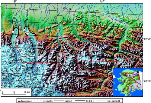
FIGURE 2. Middle Valley, between the Okpilak and Jago River valleys on the north side of the Brooks Range. A series of inset late Pleistocene moraines are tightly nested about 4 km downvalley from the modern glacier. Photo location shown in
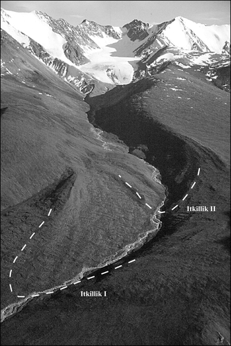
FIGURE 3. Contrast in cirque development in adjacent valleys at similar elevations. (A) Egaksrak River valley showing numerous well-developed cirques at elevations reaching 2022 m. (B) Aichillik River valley showing poorly developed cirques at elevations reaching 2030 m. Photo locations shown in
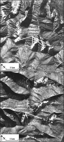
FIGURE 4. 10Be ages of the four moraines dated in the northeastern Brooks Range, arranged from oldest to youngest for each moraine. Ages are not corrected for boulder surface erosion or snow cover, both of which would result in ages ∼10% older (e.g., CitationBriner et al., 2002). The clustering of the ages on the Hubley moraine and Jago River valley left lateral moraine suggests that the average ages closely represent the depositional age of the moraines. In contrast, the wide scatter of ages on the Jago River valley end moraine and the Okpilak River valley moraine hampers the age interpretation of the 10Be analyses
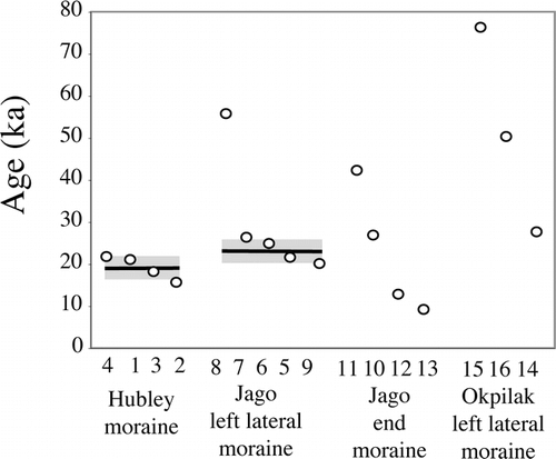
FIGURE 5. Topographic profile across the northeastern Brooks Range (A to A′ in ) showing Itkillik II equilibrium-line altitudes (ELAs), and modern glacier median elevations. Boxes mark the ELAs of the glaciers mapped in the Middle valley (informal name) and the Leffingwell River valley where the moraines can confidently be assigned to the Itkillik II glaciation. Solid line shows the least-squares linear regression of ELAs
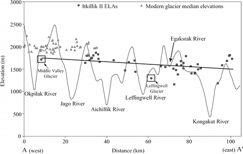
TABLE 1 Summary of relative-weathering data from Pleistocene deposits in the northeastern Brooks Range (this study) compared to the northern valleys of the central Brooks (CitationHamilton, 1994)
TABLE 2 10Be age information for moraine boulders of the northeastern Brooks Range
TABLE 3 Average equilibrium-line altitudes (ELAs) for glaciers of the Itkillik II glaciation
Acknowledgments
This project was funded by National Science Foundation grants OPP-9977974 and OPP-9977972, and a Geological Society of America graduate research grant. We thank the U.S. Fish and Wildlife Service and VECO Polar Resources for logistical support; Robert Finkel for assistance with 10Be measurements at Lawrence Livermore National Laboratory; Rob Richardson and Janelle Sikorski for assistance in the field; and Lee Dexter, Michael Ort, and Paul Umhoefer for their input. Thomas Hamilton contributed extensively to our understanding of Brooks Range glacial geology; he and an anonymous reviewer provided helpful comments on an earlier draft.
Notes
Revised ms submitted December 2004
Related Research Data
References Cited
- Balascio, N. L. 2003. Equilibrium-line altitudes across the Brooks Range, Alaska during the last glacial maximum. M.S. thesis, Northern Arizona University, Flagstaff, 105 pp.
- Balascio, N. L. , D. S. Kaufman , and W. F. Manley . in press. Equilibrium-line altitudes during the last glacial maximum across the Brooks Range, Alaska. Journal of Quaternary Science.
- Briner, J. P. , D. S. Kaufman , A. Werner , M. Caffee , L. Levy , W. F. Manley , M. R. Kaplan , and R. Finkel . 2002. Glacier readvance during the late glacial (Younger Dryas?) in the Ahklun Mountains, southwestern Alaska. Geology 30:679–682.
- Briner, J. P. , D. S. Kaufman , W. F. Manley , R. C. Finkel , and M. W. Caffee . 2005. Cosmogenic exposure dating of late Pleistocene moraine stabilization in Alaska. Geological Society of America Bulletin 117:1108–1120.
- Carter, L. D. , O. J. Ferrians Jr. , and J. P. Galloway . 1986. Engineering-geologic map of northern Alaska coastal plain and foothills of the Arctic National Wildlife Refuge. U.S. Geological Survey Open-File Report 86-334, 1:250,000.
- Coulter, H. W. , T. L. Péwé , D. M. Hopkins , C. Wahrhaftig , T. N V. Karlstrom , and J. R. Williams . 1965. Map showing extent of glaciations in Alaska. U.S. Geological Survey Miscellaneous Geologic Investigations Map I-415, 1:2,500,000.
- Daly, C. , R. P. Neilson , and D. L. Phillips . 1994. A statistical-topographic model for mapping climatological precipitation over mountainous terrain. Journal of Applied Meteorology 33:140–158.
- Daly, C. , W. P. Gibson , G. H. Taylor , G. L. Johnson , and P. Pasteris . 2002. A knowledge-based approach to the statistical mapping of climate. Climate Research 22:99–113.
- Dyurgerov, M. 2002. Glacier Mass Balance and Regime: Data of Measurements and Analysis. INSTAAR Occasional Paper 55, University of Colorado, 268 pp.
- Evison, L. H. , P. E. Calkin , and J. M. Ellis . 1996. Late-Holocene glaciation and twentieth-century retreat, northeastern Brooks Range, Alaska. The Holocene 6:17–24.
- Grantz, A. , S. D. May , and P. E. Hart . 1994. Geology of the Arctic continental margin of Alaska. In Plafker, G., and Berg, H. C. (eds.), The Geology of Alaska, The Geology of North America, G-1. Boulder, Colorado: Geological Society of America, 17–48.
- Hamilton, T. D. 1986. Late Cenozoic glaciation of the central Brooks Range. In Hamilton, T. D., Reed, K. M., and Thorson, R. M. (eds.), Glaciation in Alaska—The geologic record. Alaska Geological Society, 9–49.
- Hamilton, T. D. 1994. Late Cenozoic glaciation of Alaska. In Plafker, G., and Berg, H. C. (eds.), The Geology of Alaska. The Geology of North America, G-1. Boulder, Colorado: Geological Society of America, 813–884.
- Hamilton, T. D. 2003. Surficial geology of the Dalton Highway (Itkillik-Sagavanirktok Rivers) area, southern Arctic Foothills, Alaska. Alaska Department Natural Resources/Division Geological & Geophysical Surveys, Professional Report 121, 32 pp.
- Hamilton, T. D. and S. C. Porter . 1975. Itkillik glaciation in the Brooks Range, northern Alaska. Quaternary Research 5:471–497.
- Haugen, R. K. 1979. Climatic investigations along the Yukon River to Prudhoe Bay Haul Road, Alaska, 1975–1978. Informal extract from Final Federal Highway Administrative Contract Report, Environmental Engineering Investigations along the Yukon River Prudhoe Bay Haul Road, Alaska: Hanover, New Hampshire: U.S. Army Cold Regions Research and Engineering Laboratory, 23 pp.
- Holmes, G. W. and C. R. Lewis . 1965. Quaternary geology of the Mount Chamberlin area, Brooks Range, Alaska. U.S. Geological Survey Bulletin 1201, 32 pp.
- Kaufman, D. S. and P. E. Calkin . 1988. Morphometric analysis of Pleistocene glacial deposits in the Kigluaik Mountains, northwestern Alaska, U.S.A. Arctic and Alpine Research 20:273–284.
- Kaufman, D. S. and W. F. Manley . 2004. Pleistocene maximum and late Wisconsin glacier extents across Alaska, U.S.A. In Ehlers, J., and Gibbard, P. L. (eds.), Quaternary Glaciations—Extent and Chronology. Part II: North America. Developments in Quaternary Science Volume 2. Amsterdam: Elsevier, 9–27.
- Lal, D. 1991. Cosmic ray labeling of erosion surfaces: in-situ nuclide production rates and erosion models. Earth and Planetary Science Letters 104:424–439.
- Manley, W. F. in press. Geospatial inventory and analysis of glaciers: A case study for the eastern Alaska Range, in Glaciers of Alaska. In Williams, R. S., Jr., and Ferrigno, J. G. (eds.), Satellite Image Atlas of Glaciers of the World. U.S. Geological Survey Professional Paper 1386-K.
- Manley, W. F. and D. S. Kaufman . 2002. Alaska PaleoGlacier Atlas. Institute of Arctic and Alpine Research (INSTAAR), University of Colorado, http://instaar.colorado.edu/QGIS/ak_paleoglacier_atlas, v. 1.
- O'Sullivan, P. B. , P. F. Green , S. C. Bergman , J. Decker , I. R. Duddy , A. W. Gleadow , and D. L. Turner . 1993. Multiple phases of Tertiary uplift and erosion in the Arctic National Wildlife Refuge, Alaska, revealed by apatite fission track analysis. American Association of Petroleum Geologists Bulletin 77:359–385.
- Péwé, T. L. 1975. Quaternary Geology of Alaska. U.S. Geological Survey Professional Paper 385, 145 pp.
- Phillips, R. L. and A. Grantz . 1997. Quaternary history of sea ice and paleoclimate in the Amerasia basin, Arctic Ocean, as recorded in the cyclical strata of the Northwind Ridge. Geological Society of America Bulletin 109:2–16.
- Plafker, G. , L. M. Gilpin , and J. C. Lahr . 1994. Neotectonic map of Alaska. In Plafker, G., and Berg, H. C. (eds.), The Geology of Alaska. The Geology of North America, G-1. Boulder, Colorado: Geological Society of America, Plate 12.
- Porter, S. C. 2001. Snowline depression in the tropics during the last glaciation. Quaternary Science Reviews 20:1067–1091.
- Porter, S. C. , K. L. Pierce , and T. D. Hamilton . 1983. Late Wisconsin mountain glaciation in the western United States. In Porter, S. C. (ed.), Late Quaternary Environments of the United States. Minneapolis, Minnesota: University of Minnesota Press, 71–111.
- Rabus, B. T. and K. A. Echelmeyer . 1998. The mass balance of McCall Glacier, Brooks Range, Alaska, U.S.A.; its regional relevance and implications for climate change in the Arctic. Journal of Glaciology 44:333–351.
- Reed, B. L. 1968. Geology of the Lake Peters area, northeastern, Brooks Range, Alaska. U.S. Geological Survey Bulletin 1236, 132 pp.
- Reiser, H. N. , W. P. Brosgé , J. T. Dutro Jr. , and R. L. Detterman . 1980. Geologic map of the Demarcation Point quadrangle, Alaska. U.S. Geological Survey Miscellaneous Investigation Series Map I-1133, 1:250,000.
- Sable, E. G. 1977. Geology of the western Romanzof Mountains, Brooks Range, northeastern Alaska. U.S. Geological Survey Professional Paper 897, 84 pp.
- Stone, J. O. 2000. Air pressure and cosmogenic isotope production. Journal of Geophysical Research 105:23753–23759.
- Vincent, J. S. 1989. Quaternary geology of the northern Canadian Interior Plains,. In Fulton, R. J. (ed.), Chapter 2 of Quaternary Geology of Canada and Greenland. Geology of Canada. Geological Survey of Canada, 97–176.
- Wallace, W. K. and C. L. Hanks . 1990. Structural provinces of the northeastern Brook Range, Arctic National Wildlife Refuge, Alaska. American Association of Petroleum Geologists Bulletin 74:1100–1118.