Abstract
Active layer thickness was monitored along three ephemeral streams in the Taylor Dry Valley of Antarctica during the 1997–1998 summer season. Five to seven cross sections were established on each stream, and the thickness of the active layer was measured every 1.5 m over intervals ranging from 2 to 30 days. Active layer depths ranged from a minimum of 3 cm in early November to a maximum of 60 cm in late January, and the depth of the active layer increased rapidly as summer temperatures climbed above freezing. While there were significant differences in the thickness of the active layer among the three streams, the timing of rapid thaw was similar for all cross sections. Changes in active layer thickness were responsive to both daily and seasonal changes in air temperature. There was more rapid thaw under the areas with flowing water, suggesting a transfer of heat from meltwater into the underlying sediments, and some evidence of an insulating effect during cold periods. Active layer thickness was not strongly related to modeled differences in incoming solar radiation using 30 m grid cells.
Introduction
The lack of vegetation, absence of a continuous ice or snow cover, and presence of ephemeral streams makes the McMurdo Dry Valleys in Antarctica a globally unique environment. Relatively warm temperatures and constant daylight during the 8–12 week summer generates melt from the lower parts of the alpine glaciers that surround the dry valleys (). This transient summer melt sustains a series of ephemeral streams that drain into perennially ice-covered lakes on the valley floors (CitationBomblies, 1998; CitationMcKnight et al., 1999). There is no evidence of liquid groundwater outside the wetted perimeter of the stream channels, and snowmelt inputs are extremely limited due to the low annual precipitation (<10 cm), strong winds, and high pressure deficit. The ephemeral streams and adjacent wet areas are the only locations where there is sufficient water to support perennial algal mats and engender significant chemical weathering (CitationGooseff et al., 2002; CitationMaurice et al., 2002). Hence, the streams are the dominant sources of water and nutrients to the closed basin lakes. The rate and extent of the seasonal thaw in and adjacent to the stream channels is critical to understanding many of the physical and biological processes that control the structure and function of the dry valleys ecosystems (CitationDoran et al., 2002).
Mean annual air temperatures in the dry valleys are −20°C, and the mean daily air temperatures during the austral summer rarely exceed 2°C (CitationKeys, 1980). These low temperatures cause permafrost to be present throughout the dry valleys (CitationCartwright and Harris, 1998). Permafrost is perennially frozen ground, and it is more specifically defined as bedrock, organic, or earth material that has temperatures below 0°C, independent of water content, for at least two consecutive years (CitationBrown and Kupsch, 1974). Two types of permafrost are found in the dry valleys: ice-cemented permafrost and dry permafrost. Ice-cemented permafrost contains sufficient interstitial moisture so that individual grains are cemented together, while dry permafrost has insufficient interstitial moisture for cementation to occur (CitationFerrians et al., 1969).
The active layer is the layer above the permafrost that seasonally freezes and thaws. The rate and depth to which the active layer thaws is primarily controlled by the heat flux coming into the ground. Temperatures at the ground surface closely follow fluctuations in air temperature, and this fluctuation is attenuated with increasing depth. With increasing depth there also is an increased lag between air temperature changes and the resulting subsurface temperatures. The degree of attenuation and the time lag are determined by the thermal diffusivity of the soil, which in turn is controlled by physical soil properties such as grain size and moisture content (CitationDingman, 1975). The depth at which the temperature never exceeds 0°C is defined as the permafrost table, and by definition the permafrost table is the lower boundary of the active layer. In the dry valleys, the thickness of the active layer is believed to be about 20–40 cm (CitationCampbell et al., 1997).
At the end of the warm season the unfrozen active layer begins to re-freeze with the decline in mean air temperatures. Freezing occurs both downward from the ground surface and upward from the permafrost table (CitationOsterkamp and Romanovsky, 1997). As with thawing, the rate of freezing depends on the air temperature, active layer thickness, soil water content, soil properties, and mean annual temperature of the permafrost surface (CitationOsterkamp and Romanovsky, 1997; CitationRomanosky and Osterkamp, 1997).
The depth and persistence of permafrost is important because ice-cemented permafrost usually has a very low hydraulic conductivity. Infiltration tests on artificially wetted soils have shown that the hydraulic conductivity is controlled by the ice content (CitationKane and Stein, 1983). In the McMurdo Dry Valleys, the permafrost underneath and adjacent to the streams is ice-cemented, so the movement and storage of liquid water is generally limited to the active layer. Liquid water can move through frozen ground, but the rates of flow generally are very small relative to the same medium under unfrozen conditions (CitationKane and Stein, 1983).
Studies have shown that the seasonal freezing of the active layer can redistribute water within the soil (CitationBurt and Williams, 1976; CitationKane and Stein, 1983; Mackay, 1983; CitationOsterkamp and Romanovsky, 1997). In the McMurdo Dry Valleys, this redistribution is most important in late summer and fall when there is a stronger temperature gradient between the descending freezing front and the warmer temperatures of the thawed active layer. In the stream channels, the freezing of liquid water reduces streamflow and creates an upward hydraulic gradient at or near the surface. The upward flow of water toward the freezing front creates higher ice contents near the surface and drier soils underneath (CitationBurt and Williams, 1976). In the absence of any soil cover or precipitation, the upward hydraulic gradient and upward migration of moisture are maintained by continuing sublimation from the soil surface, and this sublimation represents a net loss of potential streamflow. In the case of the dry valleys, winter sublimation is believed to dry out a relatively thin surface layer, but most of the underlying soil is ice-cemented from freeze-up in February until thaw begins in late October or early November.
Given the unique environment of the dry valleys, the thawing of the active layer is an important control on the storage and delivery of streamflow, the amount of chemical weathering, and the presence of algal mats. With respect to streamflow, the seasonal thaw of the active layer effectively increases the volume that must be filled by glacial melt, and this results in an unfrozen saturated zone underneath and adjacent to the stream channels (CitationConovitz, 2000). The saturated areas underneath and adjacent to the stream are known as the hyporheic zone (CitationValett et al., 1990), and numerous studies have documented an active exchange of water between the stream and the hyporheic zone (CitationTriska et al., 1989, Citation1993; CitationValett et al., 1990; CitationWondzell and Swanson, 1999). Studies have confirmed a similar exchange between the streams and the hyporheic zone in the dry valleys (CitationMcKnight and Andrews, 1993; CitationRunkel et al., 1998).
Because significant quantities of water are found only in the streams, lakes, and adjacent hyporheic zones, these are the only areas where rapid chemical weathering occurs. The seasonal increase in active layer thickness greatly increases the area of exposed sediment surfaces in contact with relatively dilute glacial meltwater, and hence the rate of chemical weathering (CitationMaurice et al., 2002). Hyporheic zone weathering is a dominant control on stream water chemistry within the dry valleys due to the absence of liquid water elsewhere in the surrounding landscape (CitationCampbell et al., 1998; CitationGooseff et al., 2002). The water in the hyporheic zone generally has a much longer residence time than the water in the stream channel, and the longer residence time promotes chemical weathering reactions (CitationRunkel et al., 1998). The ongoing exchange of water between the streams and the hyporheic zone transfers these weathering products into the streams and ultimately the closed-basin lakes. Hence these weathering products are a critical input to the overall biogeochemical cycles in the dry valleys (Green et al., 1988; CitationMcKnight and Andrews, 1993; CitationHoward-Williams et al., 1997; CitationMcKnight et al., 1998; CitationLyons et al., 1998; CitationRunkel et al., 1998).
Active layer depths vary over large regional scales due to climate differences, and over smaller scales due to differences in topography, soil, and vegetative cover (CitationIves, 1973; CitationNelson et al., 1999). Over larger temporal and spatial scales, differences in the depth of the active layer can be a relatively sensitive indicator of climatic differences and site conditions (CitationNelson et al., 1999, CitationHinkel et al., 1996; CitationNelson et al., 1997; CitationZhang et al., 1997). CitationZhang et al. (1997) found active layer thickness to be directly proportional to summer air temperatures and the length of the thaw season. Since small changes in the climate of the dry valleys can have relatively large effects on key watershed processes such as meltwater generation, long-term active layer monitoring may be a useful indicator of local climate change.
There have been no systematic measurements of the rate of thaw, or the thickness of the active layer in and adjacent to the stream channels in the dry valleys. The goal of this study was to measure the changes in the thickness of the active layer in and adjacent to three streams in Taylor Dry Valley. The specific objectives were to: (1) measure the spatial and temporal changes in the active layer over the course of the summer season; (2) measure the spatial variability in the rate of thaw and thickness of the active layer within cross sections, between cross sections, and between streams; (3) determine whether the presence of streamflow affects the rate at which the active layer thaws and refreezes; and (4) relate active layer thaw to air temperatures and incoming solar radiation. This information is needed to better understand the amount and timing of streamflow delivered to the lakes on the valley bottoms, as well as the solute fluxes from chemical weathering in the hyporheic zone. A more comprehensive understanding of active layer processes is integral to understanding the response of dry valley ecosystems to past and future climate change.
Study Area
THE DRY VALLEYS
The McMurdo Dry Valleys region (77°00′S, 162°52′E) comprises the largest ice-free area in Antarctica. Three main valley systems—the Taylor, Wright, and Victoria Valleys—account for the majority of this area, although there are a number of smaller subvalleys to the north, south, and west. The valleys range from 80 to 100 km in length and 5 to 10 km in width, and there is up to 3 km of topographic relief between the valley floors and adjacent mountain peaks (CitationPrentice et al., 1998). Collectively, the ice-free valleys and adjacent coastal areas account for less than 5% of the Antarctic continental area (CitationDrewery et al., 1982).
The Lake Fryxell basin is the easternmost lake basin in the Taylor Valley and is approximately 6 km long by 8 km wide (). It is a closed basin, as a slight divide to the east separates it from the sea. The basin is bordered to the west and separated from Lake Hoare by the Canada Glacier. To the northeast lies the Commonwealth Glacier. Other major glaciers in the Fryxell basin include the Howard Glacier and the Kukri Hills Glaciers, both of which lie to the south. A total of 13 streams emanate from the surrounding glaciers and flow into Lake Fryxell.
Algal mats exist in most streams and persist from summer to summer. Green, orange, and red-colored algal mats tend to establish within the main channel, while black-colored algal mats are primarily found in the wetted zone adjacent to the stream channel (CitationAlger et al., 1997). The mats only grow where there are saturated or near-saturated zone conditions for at least part of the summer. The algal mats extending beyond the wetted channel depend on the saturated, or near saturated, zone resulting from the movement of streamwater into the adjacent sediments (CitationMcKnight et al., 1998). During the winter the mats exist in a “freeze-dried” state.
The three study streams were all in the Lake Fryxell basin because of the time required to travel between lake basins, ease of access, available infrastructure, and the presence of long-term stream gauging stations. Aiken Creek, von Guerard Stream, and Delta Stream were selected as the three study streams within the Lake Fryxell basin because of their relative proximity, ease of access from a small field hut, and differences in aspect, length, and annual streamflow ().
AIKEN CREEK
Aiken Creek is comprised of two main reaches (). The upper reach originates from Commonwealth Glacier and flows southwest for 2 km before it reaches Many Glaciers Pond. The lower reach of Aiken Creek flows eastwards from Many Glaciers Pond for 1.3 km before entering the eastern end of Lake Fryxell. The pond must be filled before water drains into the lower reach, and once filled it can sustain streamflow when colder temperatures temporarily inhibit glacier melt.
Aiken Creek flows through alluvium composed mostly of unconsolidated sand and sandy gravel. The channel is moderately incised for approximately 300 m below Many Glaciers Pond, and here the bed is dominated by stone pavements largely colonized by algal mats. Below this incised section the channel widens and flattens out. Stone pavements are present at various locations along the lower reach, but the bed surface is mostly sand. The mean gradient is only 0.01 m/m. A continuously recording stream gauge is located approximately 100 m from the outlet to Lake Fryxell (). Streamflow in Aiken Creek during the 1997–1998 season began in late November and continued until the end of January (). The total flow in 1997–1998 was 3.7 × 10⁴ m3, or 37% of the mean annual flow.
VON GUERARD STREAM
The von Guerard Stream originates from the Kukri Hills Glaciers and flows into the southeastern end of Lake Fryxell (). It is 5 km long and has an average gradient of 0.02 m/m. The short upper reaches are steeper and have a bed of large cobbles and boulders. Below these steep reaches, the stream flows through a wide, flat area before entering a reach with a moderate gradient. The channel then widens and flattens before it flows into Lake Fryxell. Both the middle and lower reaches are composed of unconsolidated sands and gravelly sands with some stone pavements. The stream gauge is located approximately 0.25 km from the stream outlet.
A sandbag diversion wall was constructed in the upper portion of the stream during the 1994–1995 field season as part of a separate long-term experiment. At low flows, the sandbag wall directs the majority of water into a separate and previously dormant stream channel. During the 1997–1998 season flow was recorded at the gauge for only six days in late December. The total flow at the gauge was just 7.1 × 10² m3, or 2% of the measured flow at Aiken Creek.
DELTA STREAM
Delta Stream originates from Howard Glacier and flows into the southernmost end of Lake Fryxell (). There are two distinct tributaries emanating from Howard Glacier, and the maximum length of Delta Stream is 11 km. Immediately below the glacier Delta Stream is wide and flat, and the bed consists of a stone pavement with abundant algal mats. It then flows through a steep reach, approximately 0.25 km in length, where the bed consists of cobbles and boulders. Below this steep section the gradient decreases and the stream flows through unconsolidated alluvium. In the lower reaches the stream channel is well defined in some places and anastomosing in others. The stream gauge is approximately 0.25 km from the outlet to Lake Fryxell. The total flow in 1997–1998 was 6.1 × 10³ m3, or roughly midway between the measured flows in the other two streams.
Methods
On each stream a series of 5–7 transects was established (). Each transect included the valley bottom and adjacent sideslopes, and the left and right edges of each transect were marked with rock cairns. Active layer depths were measured from the left to right cairns at 1.5-m intervals by pushing a T-shaped metal probe into the ground until the frozen boundary was reached. The stem of the probe was 1.5 m long, approximately 1 cm in diameter, and marked in centimeters. The depth to the frozen boundary was read from the markings on the probe. The frozen boundary was easily detected by a marked change in resistance as the probe was pushed into the soil. At each location the probe was inserted several times in order to obtain an average depth to the base of the active layer. Occasionally the probe would hit a buried cobble but the differences between hitting rock and frozen ground was easily discernable to the observer. When this situation arose, the measurement location was shifted slightly until the base of the active layer was reached. All of the active layer depth data can be accessed through the McMurdo Dry Valleys Long-Term Ecological Research Project (MCM LTER) database (http://huey.colorado.edu). The cross section at each transect was surveyed with an auto-level and stadia rod, and the width of the hyporheic zone was inferred from the outer limits of surface wetting or algal growth. Water temperature data were continuously collected at each gauging station.
The accuracy of the active layer measurements was assessed by having two observers measure the thickness of the active layer across the same transect on von Guerard Stream. The difference in the mean depth of the active layer across the entire cross section was 0.5 cm. The mean difference for individual points along the cross section was 1.4 cm, and the standard deviation was 1.5 cm. These comparisons indicate that the measured depths are relatively reliable, and all the data reported here were collected by the two senior authors.
To the extent possible, all of the transects for a given stream were measured on the same day, and all three streams were measured on successive days. However, two or three days were sometimes needed to measure all of the transects on a particular stream, and up to a week was required to measure all of the cross sections. The comparisons between streams are based primarily on an early season set of data collected from 20 to 26 November 1997, a mid-season data set collected from 29 December 1997 to 5 January 1998, and a late season data set collected from 25 to 30 January 1998.
Differences in active layer depths among the three streams were evaluated with the least squares means method using a significance level of 0.05 (CitationSAS Institute, 1998). Differences between dates and cross sections for an individual stream were tested as well as differences among streams. The effect of short-term changes in temperature on the thickness of the active layer was assessed by making successive measurements across selected transects during the last week in November.
Incoming solar radiation values were obtained from a solar radiation model developed for the Taylor Valley (CitationDana et al., 1998). The model was developed from in situ radiation measurements and corrected for topographic effects using a digital elevation map (DEM). The model was used to generate incoming solar radiation values for each 30-m grid cell for December 1994. The month of December was chosen because this is the month of the solar maximum, and biologic and hydrologic processes are most active. We assumed that the relative amounts of solar radiation in December 1997 would be similar to the modeled values for December 1994.
In order to match the permafrost transect locations with the digital elevation map used in the radiation model, the perimeter of the valley bottom along each stream and the location of each transect were mapped with a kinematic GPS unit. Incoming solar radiation values were obtained from the model for each transect, and these were compared to the mean depth of the active layer for each transect. The radiation values for the perimeter of the valley bottom along each reach were averaged to calculate the incoming radiation for the entire stream, and these values were compared to the mean depth of the active layer for each stream.
Results
SEASONAL CHANGES IN ACTIVE LAYER DEPTHS
Active layer depths were shallowest at the beginning of the summer and progressively deepened with time on all three streams (). The temporal patterns in active layer thaw generally followed the changes in air temperature (). The first sets of data were collected only on Delta Stream, and these showed that the mean depth of the active layer was less than 4 cm until 15 November. The early season data represent the first complete set of data for all streams, and at this time the mean depth of the active layer was 7 cm for Aiken Creek, 14 cm for von Guerard Stream, and 15 cm for Delta Stream (). These early season values were significantly lower than the mid- and late season values shown in . In general, the thickness of the active layer increased in the second half of November as mean air temperatures climbed above freezing, but two of the streams showed a transient decrease in active layer thickness in response to the colder air temperatures in the last few days of November and the first two weeks of December ().
Active layer depths increased by 19–22 cm with increasing air temperatures in the second half of December ( and ). In Delta Stream, the mean mid-season depth for all transects was 43 cm, and the corresponding value for von Guerard Stream was 34 cm. In Aiken Creek, the mean mid-season active layer thickness was only 29 cm, and this was significantly less than (P ≤ 0.05) the corresponding mid-season values for both Delta and von Guerard Streams.
For Delta Stream, the mean active layer depth increased by another 8 cm from the mid-season measurements on 4–5 January to the late season measurements on 24–25 January ( and ). In contrast, the mean increase in the thickness of the active layer from mid- to late season was less than 1 cm on Aiken Creek and only 3 cm on von Guerard Stream. The changes in mean depth from mid- to late season were significant for Delta and von Guerard Streams.
The maximum mean active layer depth for Delta Stream was 51 cm, while the maximum mean depths for von Guerard Stream and Aiken Creek were 37 cm and 29 cm, respectively (). The more frequent measurements on Delta Stream during January confirmed that the maximum depth was obtained at the time of the last measurement on 24 January, even though the mean air temperatures had already begun to decline (). These data are consistent with the expected lag between the maximum air temperature and the maximum depth of the active layer, and the apparent lag in the response of the active layer on Delta and von Guerard streams to the colder air temperatures in late November/early December.
Over the course of the season there generally was an increase in the absolute variability in active layer depths between transects (). On 20 November, the mean of the individual transects in Aiken Creek ranged from 7 to 9 cm, and the standard deviation was only 0.7 cm (). By 30 January, the standard deviation of the transect means on Aiken Creek had increased to 4 cm. For Delta Stream the standard deviation of the transect means consistently increased from 1.2 cm on 21 November to 5.6 cm in early January and 6.2 cm on 25 January (). For von Guerard Stream, the largest variability between transects was in mid-season, when the standard deviation of the transect means was 4.5 cm ().
CHANGES IN ACTIVE LAYER THICKNESS IN RESPONSE TO AIR TEMPERATURE AND STREAM HYDROLOGY
The repeated measurements from 26 November to 13 December illustrate the short-term responsiveness of the active layer to changing air temperatures. When air temperatures dropped to −9°C at the end of November, the thickness of the active layer in Aiken Creek decreased by 8 to 11 cm within 24 h (). Similarly, the 5°C drop in mean daily air temperatures from 26 to 30 November caused the depth of the active layer to decrease by 8 to 9 cm on transects 1 and 2 in von Guerard Stream. Although we were not able to make repeated measurements on the same set of cross-sections in Aiken Creek, the minimal variability between transects () indicates that the increase in air temperatures from 29 November to 1 December caused a concurrent increase in active layer thickness ().
On a seasonal basis, surface streamflow and the extent of the hyporheic zone appear to affect the development and thickness of the active layer. Because the streams are relatively wide, shallow, and dark-bottomed, streamwater temperatures can be much higher than the ambient air temperatures (), and this can result in the transfer of sensible heat to the hyporheic zone. The inflows of warmer surface water can accelerate the downward and lateral expansion of the active layer. shows that on 9 December the active layer directly underneath the wetted channel in Aiken Creek was approximately 15 cm deeper than the active layer immediately adjacent to the stream. As temperatures warmed there was progressively less difference between the depth of the active layer underneath the stream channel and the active layer outside of the channel, but on Aiken Creek the active layer was still thicker underneath the wetted channel through the last set of measurements on 30 January (). A deeper active layer underneath the channel and hyporheic zone also was apparent at transect 5 in Delta Stream from 3 December to the last measurement on 25 January (), and this roughly corresponds to the period with streamflow. There is much less evidence for a thicker active layer underneath the channel in von Guerard Stream (), and this is probably due to the much smaller amount of streamflow and the corresponding reduction in sensible heat transfer to the subsurface.
Water in the active channel also can affect the short-term variability in active layer depths. Successive measurements on Aiken Creek showed little change in the thickness of the active layer underneath the wetted channel in response to the decline in air temperatures in late November (). The continuing streamflow from Many Glaciers Pond probably provided some sensible heat and helped insulate the underlying hyporheic zone from refreezing. In contrast, the entire active layer on the flatter right-hand side of the channel froze solid within 24 h (). The 15-cm decline in active layer thickness in this area can be attributed to the near complete freezing of the hyporheic zone, as this area was not protected by surface streamflow, and the interstitial flow apparently was too slow to transfer much sensible heat.
ACTIVE LAYER THAW AND INCOMING SOLAR RADIATION
The mean maximum depth of the active layer for each stream was not correlated with the modeled inputs of solar radiation, but the between-stream differences in the solar radiation inputs were very small (). When the data were stratified by stream, the predicted solar radiation inputs for each transect were correlated with the measured mean depth of the active layer in late January (). This relationship was strongest for the five transects on Aiken Creek (R 2 = 0.73), but the R 2 was only significant at P ≤ 0.06 (). The R 2 between the modeled radiation inputs and the mean depth of the active layer at each transect was 0.27 for von Guerard Stream and 0.28 for Delta Stream, but neither of these relationships was statistically significant (). The weak P-values can be attributed to the small sample size, relatively small spread in the data (e.g., von Guerard Stream in ), and the scatter around the regression line (e.g., Delta Stream in ).
Discussion
The seasonal increase in the depth of the active layer underneath and adjacent to the wetted perimeter shows a progressive expansion in the hyporheic zone over the summer. This implies that hyporheic waters are important for chemical weathering and heat transfer, as the continuing melt further increases the amount of chemical weathering and the downstream transport of the weathering products (CitationGooseff et al., 2002). Once thawed, the sediments within the hyporheic zone are bathed by flowing water, which sustains a high rate of chemical weathering.
The expansion of the active layer over the course of the summer has a direct influence on the volumes of streamflow delivered to the lakes. As the active layer expands vertically, this increases the potential volume for hyporheic storage underneath and adjacent to the stream channel. A larger hyporheic volume will increase the amount of water lost to evaporation and in situ freezing at the end of the summer. It is not known how much of this stored water will be delivered to the lakes in the following year, as this water will be subject to sublimation and evaporation losses. In colder summers, the volume of glacial melt is much less so a larger proportion of the melt will be “lost” to hyporheic storage. The varying proportion of meltwater that is lost to hyporheic storage probably contributes to the observed high interannual variability in annual streamflow, particularly in the longer streams (CitationConovitz, 2000).
At the cross-section scale, stream hydrology both influences and is influenced by the thawing active layer. The relatively warm streamwater transfers heat to the subsurface and accelerates active layer thaw. This is particularly evident underneath the channel on Aiken Creek () and in the development of the extensive hyporheic zone on the right-hand side of the active channel on transect 5 of Delta Stream (). The depth of the active layer at the latter location corresponds with the boundaries of the hyporheic zone as estimated from the algal growth on either side of the stream channel (CitationConovitz, 2000).
The weak relationships between active layer thickness and modeled incoming solar radiation were surprising. Both Delta and von Guerard Streams are generally north-facing () and were expected to receive more incoming solar radiation, while Aiken Creek has a more westerly aspect. The active layer depths do follow the pattern due to aspect, as the active layer in both Delta and von Guerard Streams was significantly deeper than in Aiken Creek (). However, the estimated solar radiation input for Delta Stream was slightly lower than for von Guerard and Aiken streams.
At the stream scale, the poor relationship between predicted solar radiation and mean active layer depth may be due to the very small differences in radiation inputs (<1%), and the fact that these differences may be less than the error in the predicted radiation inputs. Potential sources of error include spatial variations in cloudiness, small-scale variations in topography, and measurement errors (CitationDana et al., 1998). Some cross sections were in incised reaches, some had a steep bank on one side of the channel, and others were on relatively flat ground. The 30-m DEM generally will not be able to capture these small-scale variations in topography and their resulting effect on the incoming solar radiation. The varying materials and algal growth within the valley bottoms also will affect the local albedo and hence the net energy balance. A final source of uncertainty is the changes in air temperature with elevation, as the transects varied in elevation in accordance with the elevation of the source area and the distance from the source glacier.
This study helps elucidate some of the interactions between active layer dynamics, hydrology, stream biology, and meteorology. A better understanding of these interactions is essential for interpreting the growing wealth of physical and ecological data from the dry valleys. Of particular interest is the fact that relatively small changes in temperature can cause very large changes in glacial melt and streamflow. This means that the glaciers, streams, and ice-covered lakes are extremely sensitive to changes in climate (CitationDoran et al., 2002).
Repeated measurements of the active layer can serve as another potential indicator of local climate change. Active layer monitoring in the dry valleys may be a more reliable indicator of climate change than active layer monitoring in other regions because of the relative simplicity of the local ecosystems. In the dry valleys one doesn't have to account for the complexities of vegetative cover, snow cover is both rare and transient, and the soil properties are relatively homogeneous. The absence or greatly reduced effect of these confounding variables means that one can much more easily link changes in the active layer to changes in climate. This linkage is much more difficult to make in arctic regions (CitationSmith and Riseborough, 1996; CitationZhang and Stammes, 1998).
Conclusions
Repeated measurements on 18 cross sections on three streams in the McMurdo Dry Valleys showed that the depth of the active layer increased from near zero in early November to 30–50 cm in late January. The changes in the thickness of the active layer generally followed both daily and seasonal trends in air temperature. The largest increase in active layer depth occurred in December, when air temperatures were highest. The active layer was deepest on Delta Stream, followed by von Guerard Stream and Aiken Creek, respectively. These differences in active layer depths were not significantly related to the estimated differences in incoming solar radiation. The spatial variability of active layer thickness across the stream channel indicates that meltwater contributes heat to the underlying permafrost, and this results in deeper thaw depths. These increased depths will reduce the volume of water delivered to the lakes while increasing the delivery of solutes.
FIGURE 1. Map of the Lake Fryxell basin
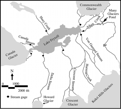
FIGURE 2. (a) Map of Aiken Creek showing locations of active layer transects. (b) Map of von Guerard Stream showing locations of active layer transects. (c) Map of Delta Stream showing locations of active layer transects
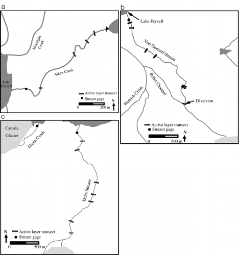
FIGURE 3. Mean active layer depths for early, mid-, and late summer in 1997–1998 for Aiken Creek, Delta Stream, and von Guerard Stream
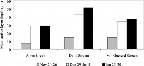
FIGURE 4. Mean thickness of the active layer and mean daily air temperatures during the 1997–1998 field season
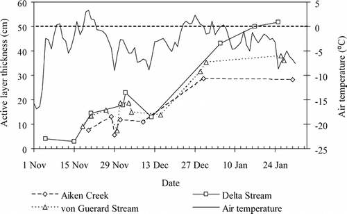
FIGURE 5. Mean active layer depth and standard deviation by transect for four different measurement dates for (a) Aiken Creek, (b) Delta Stream, and (c) von Guerard Stream. On Delta Stream, no measurements were made at transects 1 and 2 on 21 November. On von Guerard Stream, no measurements were made at transects 1 and 2 on 15 December, or at transects 3 and 4 on 21–26 December
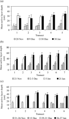
FIGURE 6. Active layer depths on Aiken Creek and mean daily air temperatures during the late November/early December cold period. No measurements were made on 28–29 November for transects 1–3, or on 1 December for transects 4 and 5
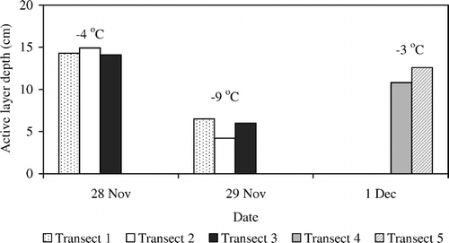
FIGURE 7. Streamwater temperatures for (a) Aiken Creek, (b) Delta Stream, and (c) von Guerard Stream during 1997–1998
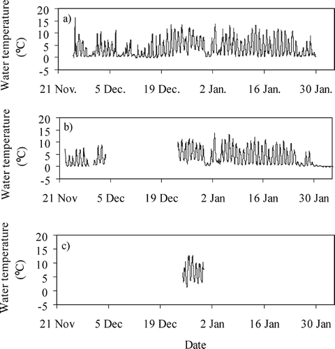
FIGURE 8. Active layer depths over time across (a) transect 4 and (b) transect 5 on Aiken Creek. The solid vertical lines represent the boundary of the active channel, and the dashed vertical lines represent the approximate boundary of the hyporheic zone
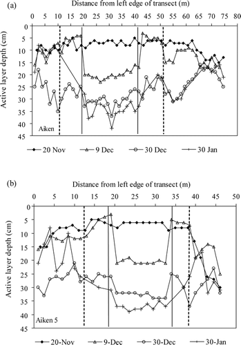
FIGURE 9. Active layer depths over time across (a) transect 5 on Delta Stream, (b) transect 2 on von Guerard Stream, and (c) transect 5 on von Guerard Stream. The vertical lines represent the boundary of the active channel, and the dashed lines represent the approximate boundary of the hyporheic zone
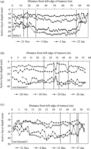
FIGURE 10. Active layer depths across transect 3 on Aiken Creek for 28 and 29 November. The vertical lines at 11 and 16 m represent the boundaries of the active channel. No hyporheic zone estimate was made at transect 3
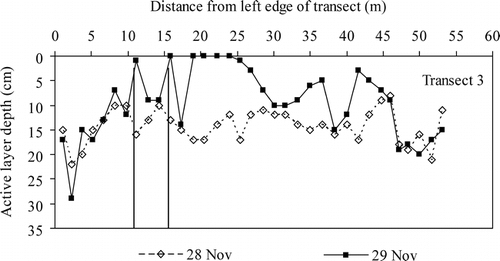
FIGURE 11. Modeled total incoming solar radiation for Aiken Creek, Delta Stream, and von Guerard Stream for December 1994. The numbers above each bar indicate the mean maximum active layer depth for each stream for the 1997–1998 field season
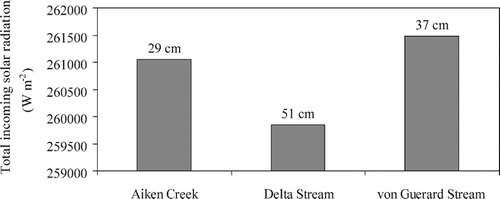
FIGURE 12. Total incoming solar radiation versus mean end of season active layer depth for each transect on (a) Aiken Creek, (b) von Guerard Stream, and (c) Delta Stream
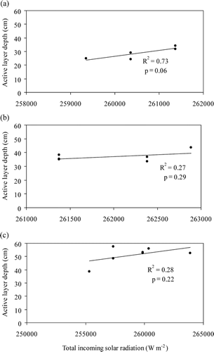
TABLE 1 Physical characteristics, duration of streamflow, and total streamflow for the three study streams
Acknowledgments
We thank Antarctic Support Associates, Camilla Correll, and Bjorn Johns for their help with field work, and Gayle Dana for providing the solar radiation model. Kelly Elder and Mike Gooseff contributed valuable comments and discussion. This research was funded in part by the National Science Foundation, Office of Polar Programs grant number OPP-9813061.
Related Research Data
References Cited
- Alger, A. S. , D. M. Mcknight , S. A. Spaulding , C. M. Tate , G. H. Shupe , K. A. Welch , R. Edwards , E. D. Andrews , and H. R. House . 1997. Ecological processes in a cold desert ecosystem: the abundance and species distribution of algal mats in glacial meltwater streams in Taylor Valley, Antarctica. Boulder, Colorado: Institute for Arctic and Alpine Research, Occasional paper no. 51.
- Bomblies, A. 1998. Climatic controls on streamflow generation from Antarctic glaciers. Master's thesis, University of Colorado, 108 pp.
- Brown, R. J E. and W. O. Kupsch . 1974. Permafrost terminology. National Research Council of Canada, Technical Memorandum no. 111, 62 pp.
- Burt, T. P. and P. J. Williams . 1976. Hydraulic Conductivity in Frozen Soils. Earth Surface Processes 1:349–360.
- Campbell, I. B. , G. G C. Claridge , D. I. Campbell , and M. R. Balks . 1997. Moisture content in the soils of the McMurdo Dry Valley region of Antarctica. In Lyons, W. B., Howard-Williams, C., and Hawes, I. (eds.), Ecosystem processes in Antarctic ice-free landscapes. Proceedings of an international workshop on polar desert systems. Washington, D.C.: National Academy of Sciences, 61–76.
- Campbell, I. B. , G. G C. Claridge , D. I. Campbell , and M. R. Balks . 1998. The soil environment of the McMurdo Dry Valleys, Antarctica. In Priscu, J. C. (ed.), Ecosystem Dynamics in a Polar Desert: the McMurdo Dry Valleys, Antarctica. Washington, D.C.:. American Geophysical Union, Antarctic Research Series 72:297–322.
- Cartwright, K. and H. J H. Harris . 1998. Hydrogeology of the dry valleys region, Antarctica. In McGinnis, L. D. (ed.), Dry Valleys Drilling Project. Washington, D.C.:. American Geophysical Union, Antarctic Research Series 33:193–214.
- Conovitz, P. A. 2000. Active layer dynamics and hyporheic zone storage in three streams in the McMurdo Dry Valleys, Antarctica. Master's thesis, Colorado State University, Fort Collins, 152 pp.
- Dana, G. L. , A. G. Fountain , and B. Wharton . 1998. Solar Radiation in the McMurdo Dry Valleys. In Priscu, J. C. (ed.), Ecosystem Dynamics in a Polar Desert: the McMurdo Dry Valleys, Antarctica. Washington, D.C.:. American Geophysical Union, Antarctic Research Series 72:297–322.
- Dingman, S. L. 1975. Hydrologic Effects of Frozen Ground. U.S. Army CRREL special report 218, 55 pp.
- Doran, P. T. , J. C. Priscu , W. B. Lyons , J. E. Walsh , A. G. Fountain , D. M. McKnight , D. L. Moorehead , R. A. Virginia , D. H. Wall , G. D. Clow , C. H. Fritsen , C. P. McKay , and A. N. Parsons . 2002. Antarctic climate cooling and terrestrial ecosystem response. Nature 415:31 517–520.
- Drewery, D. J. , S. R. Jordan , and E. Jankowski . 1982. Measured properties of the Antarctic ice sheet: surface configuration, ice thickness, volume and bedrock characteristics. Annals of Glaciology 3:83–91.
- Ferrians Jr., O. J. , R. Kahadoorian , and G. W. Green . 1969. Permafrost and related engineering problems in Alaska. U.S. Geological Survey Professional Paper 678, 37 pp.
- Gooseff, M. N. , D. M. McKnight , W. B. Lyons , and A. E. Blum . 2002. Weathering reactions and hyporheic exchange controls on stream water chemistry in a glacial meltwater stream in the McMurdo Dry Valleys. Water Resources Research 38:12 1–17.
- Green, W. J. , M. P. Angle , and K. E. Chave . 1988. The geochemistry of Antarctic streams and their role in the evolution of four lakes of the McMurdo Dry Valleys. Geochimica et Cosmochimica Acta 52:1265–1274.
- Hinkel, K. M. , F. E. Nelson , Y. Shur , J. Brown , and K. R. Everett . 1996. Temporal changes in moisture content of the active layer and near surface permafrost at Barrow, Alaska, U.S.A.: 1962–1994. Arctic and Alpine Research 28:3 300–310.
- Howard-Williams, C. , I. Hawes , A. M. Schwarz , and J. A. Hall . 1997. Sources and sinks of nutrients in a polar desert stream, the Onyx River, Antarctica. In Lyons, W. B., Howard-Williams, C., and Hawes, I. (eds.), Ecosystem Processes in Antarctic Ice-free Landscapes. Rotterdam: Balkema, 155–170.
- Ives, J. D. 1973. Permafrost and its relationship to other environmental parameters in a midlatitude, high-altitude setting, Front Range, Colorado Rocky Mountains. Proceedings of the 2nd International Conference on Permafrost. Washington D.C.: National Academy of Sciences, 159–164.
- Kane, D. L. and J. Stein . 1983. Water movement into seasonally frozen soils. Water Resources Research 19:6 1547–1557.
- Keys, J. R. 1980. Air temperature, wind, precipitation and atmospheric humidity in the McMurdo Region. Wellington, New Zealand: Geology Department, Victoria University, Publication 17, 57 pp.
- Lyons, W. B. , K. A. Welch , K. Neumann , J. K. Toxey , R. McArthur , C. Williams , D. M. McKnight , and D. Moorhead . 1998. Geochemical linkages among glaciers, streams and lakes within the Taylor Valley, Antarctica. In Priscu, J. C. (ed.), Ecosystem Dynamics in a Polar Desert: the McMurdo Dry Valleys, Antarctica. Washington, D.C.:. American Geophysical Union, Antarctic Research Series 72:297–322.
- MacKay, J. R. 1983. Downward water movement into frozen ground, west arctic coast, Canada. Canadian Journal of Earth Sciences 32:3 120–134.
- Maurice, P. A. , D. M. McKnight , L. Leff , J. E. Fulghum , and M. N. Gooseff . 2002. Direct observations of aluminosilicate weathering in the hyporheic zone of an Antarctic dry valley stream. Geochimica et Cosmochimica Acta 66:8 1335–1347.
- McKnight, D. M. , D. K. Niyogi , A. S. Alger , A. Bomblies , P. A. Conovitz , and C. M. Tate . 1999. Dry valley streams in Antarctica: ecosystems waiting for water. Bioscience 49:12 985–995.
- McKnight, D. M. and E. D. Andrews . 1993. Hydrologic and geochemical processes at the stream-lake interface in a permanently ice-covered lake in the McMurdo Dry Valleys, Antarctica. Verhandlungen Internationale Vereinigung für Limnologie 25:957–959.
- McKnight, D. M. , A. Alger , C. M. Tate , G. Shupe , and S. Spaulding . 1998. Longitudinal patterns in algal abundance and species distribution in meltwater streams in Taylor Valley, southern Victoria Land, Antarctica. In Priscu, J. C. (ed.), Ecosystem Dynamics in a Polar Desert: the McMurdo Dry Valleys, Antarctica. Washington, D.C.:. American Geophysical Union, Antarctic Research Series 72:109–127.
- Nelson, F. E. , N. I. Shiklomanov , G. R. Mueller , K. M. Hinkel , D. A. Walker , and J. G. Bockheim . 1997. Estimating active layer thickness over a large region: Kuparuk River Basin, Alaska, U.S.A. Arctic and Alpine Research 29:4 367–378.
- Nelson, F. E. , N. I. Shiklomanov , and G. R. Mueller . 1999. Variability of active layer thickness at multiple spatial scales, north-central Alaska, U.S.A. Arctic, Antarctic, and Alpine Research 31:2 179–186.
- Osterkamp, T. E. and V. E. Romanovsky . 1997. Freezing of the active layer on the coastal plain of the Alaskan Arctic. Permafrost and Periglacial Processes 8:23–44.
- Prentice, M. L. , J. Kleman , and A. P. Stroeven . 1998. The composite glacial erosional landscape of the northern McMurdo Dry Valleys: implications for Antarctic Tertiary glacial history. In Priscu, J. C. (ed.), Ecosystem Dynamics in a Polar Desert: the McMurdo Dry Valleys, Antarctica. Washington, D.C.:. American Geophysical Union, Antarctic Research Series 72:1–38.
- Romanovsky, V. E. and T. E. Osterkamp . 1997. Thawing of the active layer on the coastal plain of the Alaskan Arctic. Permafrost and Periglacial Processes 8:23–44.
- Runkel, R. L. , D. M. McKnight , and E. D. Andrews . 1998. Analysis of transient storage subject to unsteady flow: diel variation in an Antarctic stream. Journal of the North American Benthological Society 17:2 143–154.
- SAS Institute, 1998. SAS version 6.0. Cary, North Carolina: SAS Institute Inc.
- Smith, M. W. and D. W. Riseborough . 1996. Permafrost monitoring and the detection of climate change. Permafrost and Periglacial Processes 7:301–309.
- Triska, F. J. , V. C. Kennedy , R. J. Avanzino , G. W. Zwellinger , and K. E. Bencala . 1989. Retention and transport of nutrients in a third order stream in northwestern California: hyporheic processes. Ecology 70:1893–1905.
- Triska, F. J. , J. H. Duff , and R. J. Avanzino . 1993. Patterns of hydrologic exchange and nutrient transformation in the hyporheic zone of a gravel bottom stream: examining terrestrial-aquatic linkages. Freshwater Biology 29:259–274.
- Valett, H. M. , S. G. Fisher , and E. H. Stanley . 1990. Physical and chemical characterization of the hyporheic zone of a Sonoran Desert stream. Journal of the North American Benthological Society 12:40–43.
- Wondzell, S. M. and F. J. Swanson . 1999. Floods, channel change, and the hyporheic zone. Water Resources Research 35:2 555–567.
- Zhang, T. and K. Stammes . 1998. Impact of climatic factors on the active layer and permafrost at Barrow, Alaska. Permafrost and Periglacial Properties 9:229–246.
- Zhang, T. , T. E. Osterkamp , and K. Stammes . 1997. Effects of climate on the active layer and permafrost on the North Slope of Alaska, U.S.A. Permafrost and Periglacial Processes 8:45–67.