Abstract
The hydrologic system of the coastal McMurdo Dry Valleys, Antarctica, is defined by snow accumulation, glacier melt, stream flow, and retention in closed-basin, ice-covered lakes. During the austral summers from 1993–1996 and 1999–2000 to 2002–2003, fresh snow, snow pits, glacier ice, stream water, and lake waters were sampled for the stable isotopes deuterium (D) and 18O in order to resolve sources of meltwater and the interactions among the various hydrologic reservoirs in the dry valleys. This data set provides a survey of the distribution of natural water isotope abundances within the well-defined dry valley hydrologic system in Taylor Valley, which extends 20 km inland from McMurdo Sound. The three major Taylor Valley lakes are not connected to one another hydrologically, and their levels are maintained by glacial meltwater inflow and perennial ice-cover sublimation. At the valley scale, glacial ice, snow, stream, and lake waters become more depleted in δD with increasing distance from McMurdo Sound (further inland). Snow pack in glacial accumulation zones is heterogeneous, likely a result of varying storm sources (continental versus coastal), and, in general, snow pits, fresh snow samples, and glacier ice are more depleted than stream waters. Within the lake basins, glacial ice source waters are depleted by as much as 111‰ δD and 20‰ δ18O compared to lake waters. These results demonstrate the importance of in-stream fractionation at the valley scale. In-stream enrichment occurs through direct evaporation fractionation from the channel and hyporheic exchange with isotopically enriched waters in the near-stream subsurface during transport from the glacial source to lake. Furthermore, the results show that lake waters directly reflect their glacial ice sources, despite fractionation during stream transport. Inter-annual comparisons of lake profiles suggest that lake waters are directly influenced by the isotopic composition and amount of stream flow during a season.
Introduction
The study of stable isotopes of water has provided a useful method of discretizing timing and source areas of the hydrology of temperate watersheds (CitationHooper and Shoemaker, 1986; CitationTurner et al., 1987; CitationStewart and McDonnell, 1991), as well as glacial- and snowmelt-dominated watersheds (CitationEpstein and Sharp, 1959; CitationTheakstone, 1988; CitationTheakstone and Knudsen, 1989; CitationCooper et al., 1991, Citation1993; CitationTheakstone and Knudsen, 1996; CitationMcNamara et al., 1997; CitationStichler and Schotterer, 2000). In glaciated watersheds, variations in stream isotope abundances provide information on contributions of snow pack, glacial melt, and/or direct precipitation to runoff.
The hydrology of the McMurdo Dry Valleys polar desert is defined by glacial snow pack, glacier ice, intermittent valley-bottom snow, stream flow, hyporheic waters, and lake waters. The processes that control the interactions among these storage locations are glacial meltwater production, snow and ice sublimation, stream and lake water evaporation, stream discharge, and hyporheic exchange. Hyporheic exchange results in the mixing of stream water with near-stream subsurface waters that are very enriched in water stable isotopes due to evaporative fractionation (CitationGooseff et al., 2003). Previous hydrologic investigations in the McMurdo Dry Valleys polar desert have focused on glacial meltwater generation (Citationvon Guerard et al., 1995; CitationConovitz et al., 1998), stream-hyporheic zone interactions (CitationRunkel et al., 1998; CitationMcKnight et al., 1999; CitationGooseff et al., 2002, Citation2003), stream-lake interactions (CitationMcKnight and Andrews, 1993), and lake hydrology (CitationChinn, 1993; CitationBomblies et al., 2001).
Previous investigations of stable isotope distributions within dry valley hydrologic systems suggest that the use of isotopes is a promising tool for delineating and quantifying sources of water to the lakes, as well as establishing hydrologic histories of the lakes (CitationMatsubaya et al., 1979; CitationStuiver et al., 1981; CitationLyons et al., 1998a). For example, CitationMatsubaya et al. (1979) have found that saline lakes and ponds have evaporative-enriched δD and δ18O isotopic characteristics because they experience more ice-off time than freshwater lakes and ponds in the Dry Valleys. In their study of stream-lake interactions in Lake Fryxell, CitationMiller and Aiken (1996) found that waters become isotopically enriched in δD and δ18O due to evaporation during stream transport and evaporation during summer open-water in the moats of the lake, whereas isotopically depleted water may sink to the lake bottoms when the moats freeze in autumn. The findings of CitationMiller and Aiken (1996) were confirmed by the findings of CitationLorrain et al. (2002), that lake ice formation in a semi-closed system preferentially excludes isotopically depleted waters as freezing progresses downwards. Further, CitationPetit et al. (1991) suggest that D-excess in recent Antarctic snowfall can be traced to the latitude of oceanic source water.
Our approach in the study presented here was to conduct a defined survey of the natural abundance of water stable isotopes within each of the hydrologic components (snow, glaciers, streams, and lakes) in order to resolve source areas of meltwater and the interactions among the various hydrologic compartments in the dry valleys. Here we present data of a survey of stable isotopes of water (D and 18O) from the Taylor Valley hydrologic basins. Isotopic samples of snow were collected in 1993 and 1996; glacier ice samples were collected from 1993 to 1997, stream water samples were collected during the austral summers of 1993–1994, and 1999–2000. We also compare lake isotopic profiles obtained in 2002 with previously published profiles. These results provide a comprehensive understanding of the hydrologic processes which support the persistent aquatic ecosystems within this cold, dry environment.
Site Description
The McMurdo Dry Valleys are located at ∼78°S latitude, on the western edge of the Ross Sea (). The landscape is dominated by glaciers, open expanses of barren patterned ground, stream channels, and permanently ice-covered, closed-basin lakes. Soils contain cryptobiotic rotifers, tardigrades, and nematodes, but no terrestrial vegetation exists. Benthic algal mats cover many of the stream beds and lake beds (CitationAlger et al., 1997; CitationMcKnight et al., 1999). Stream flow in the Dry Valleys generally lasts for 6 to 12 weeks during the austral summer. Annually, less than 10 cm (water equivalent) of precipitation falls as snow (CitationClow et al., 1988) and in general does not provide stream flow (CitationConovitz et al., 1998). Glacier ice melt is the main source of water to streams and closed-basin lakes.
All glaciers sampled in this study are alpine glaciers, except Taylor Glacier, a terminal glacier of the East Antarctic Ice Sheet. The altitude of equilibrium lines (ELA) of the McMurdo Dry Valley glaciers vary systematically with distance from the coast (east to west) with a gradient of ∼30 m/km (CitationFountain et al., 1999). This gradient is almost an order of magnitude greater than temperate glaciers. In Taylor Valley, there is an abrupt shift at ∼700 m which produces a local gradient of ∼70 m/km (CitationFountain et al., 1999). The location of this shift of gradient is related to the location of the Nussbaum Riegel, a ridge in the valley, which acts as a meteorological barrier. These steep gradients of the ELA indicate that these glaciers can be impacted differently by changes in climate even through they are in relatively close proximity. Snow-pit data from glacier accumulation zones represent annual, and interannual, snow accumulation characteristics, and are interpreted as glacial ice source. Previous work on snow-pit geochemistry by CitationLyons et al. (2003) and ice core work at higher elevations in the Asgard Range (CitationMayewski et al., 1995) suggests that glacial snow packs are made up of primary precipitation that has been modified by the input of eolian salt and dust from the local ice-free areas.
Taylor Valley currently contains three closed-basin lakes: Lake Bonney, Lake Fryxell, and Lake Hoare (). Lake Bonney is separated into two distinct basins or lobes by a 13 m sill. The lakes vary dramatically in their chemical composition. The hypolimnia (bottom waters) of both lobes of Bonney are hypersaline, whereas Lake Fryxell has brackish bottom waters, and Lake Hoare is fresh (CitationLyons et al., 1998b). These variations in salinity reflect past response to climatic changes that are also manifest in the stable isotopic composition of their hypolimnetic waters (CitationMatsubaya et al., 1979; CitationLyons et al., 1998a). The water levels of the lakes respond quickly to relatively small climatic changes (CitationDoran et al., 2002). The lakes have been much lower than present as little as 1 ky BP, whereas during the Last Glacial Maximum and into the early Holocene, one large lake filled the valley (CitationHendy et al., 1977; CitationMatsubaya et al., 1979; CitationLyons et al., 1998a; CitationHall and Denton, 2000).
The streams of Taylor Valley connect glaciers to the major lakes on the valley floor, varying primarily in length and slope (), though all are composed of unconsolidated alluvium, moraine material, and where slope is low, desert pavement. In the Lake Bonney basin, Santa Fe Stream and Lyons Creek run adjacent to the Taylor Glacier with moderate gradients, flowing into the west lobe, and Priscu Stream has a shallow gradient, flowing into the east lobe (). In the Lake Hoare basin, the major input of water is from Andersen Stream, which runs adjacent to the Canada Glacier with a steep gradient (). In the Lake Fryxell basin, Canada Stream flows off of the east side of the Canada Glacier with a slope of 0.03 (CitationConovitz et al., 1998), and Huey Creek flows from a perennial snow pack and with a steep channel (gradient of approximately 0.06, CitationRunkel et al., 1998). Lost Seal Stream, McKnight Creek, and Aiken Creek all flow off of the Commonwealth Glacier with low slopes, and all are longer than 2 km (, ). Delta Stream is the longest stream in Taylor Valley, over 11 km (), and has a slope of 0.03 (CitationConovitz et al., 1998). Green Creek flows off of the southeast corner of the Canada Glacier with a length of less than 2 km () and moderate slope. Commonwealth Stream delivers melt from the Commonwealth Glacier to McMurdo Sound via a short and moderately sloped channel. Priscu Stream, Canada Stream, Commonwealth Stream, Aiken Creek, Delta Stream, and Green Creek all have small ponds either at their headwaters or along their paths to the lakes.
Since 1993, Taylor Valley has been the primary location of the McMurdo Dry Valleys Long Term Ecological Research (MCM LTER) program. As part of our research to better establish the climate/hydrological linkages in Taylor Valley, we have sampled snow, ice, stream, and lake waters for δD and δ18O contents.
Methods
Stable water isotope survey sample collection details are provided in . Fresh snow was collected on the Canada (n = 19) and Taylor Glaciers (n = 10). Above glacial equilibrium lines, nine snow pits were sampled throughout their depth, seven on the Commonwealth Glacier and two on the Howard Glacier. Each snow pit was located near established snow depth stakes which are monitored annually. Many ice samples from the Commonwealth, Canada, Howard, and Taylor Glaciers were collected (each n > 25), and a few ice samples were collected from the Seuss and Hughes Glaciers (each n < 7). Stream waters were sampled at stream gauges and stream outlets in ungauged streams (CitationConovitz et al., 1998). Lake Hoare and Lake Fryxell profiles were sampled during the 1993–1994 austral summer (CitationLyons et al., 1998a) and additional Lake Fryxell profiles were available for 1987, 1988, and 1989, from the work of CitationMiller and Aiken (1996). Lake Bonney was sampled 5 January 1972 and 9 January 1972, as reported by CitationMatsubaya et al. (1979). An additional set of profiles for Lakes Hoare and Fryxell were obtained in 2002–2003, after the previous very high meltwater season of 2001–2002 (C. Jaros, personal communication). In addition to these samples, both lobes of Lake Bonney were sampled above the chemocline at this time.
Stable isotope samples were collected in whirl-pack bags (ice/snow) and 60 mL polyethylene bottles (water). Snow and ice samples were kept frozen, and water samples were frozen immediately. All samples were returned to INSTAAR (Boulder, Colorado, U.S.A.) for isotopic analysis. Oxygen isotope values were determined using the technique described by CitationEpstein and Mayeda (1953), and hydrogen isotope values were determined using the technique described by CitationVaughn et al. (1998). Isotope values are presented as per mil (‰) values, relative to VSMOW,
where, RX and RSTD are the ratios of the heavy to light isotope for the sample and standard, respectively. Deuterium excess (D-excess) values were calculated as
(CitationCraig, 1963). Deuterium excess is particularly useful in delineating the origin of water vapor. Depleted D-excess values suggest that evaporation fractionation has occurred, which influences O isotopes over H isotopes due to the fact that there are half as many O molecules as there are H molecules in a parcel of water. All stable isotope data collected in 1993–1994, 1999–2000, and 2002–2003 are available at the MCM LTER web site (http://huey.colorado.edu).
Results
VALLEY-SCALE RESULTS
Comparison of δD and δ18O data to the global meteoric water line (GMWL) (CitationCraig, 1963) shows that all hydrologic compartments plot on a slope less than 8, and generally below the GMWL (). Hydrologic sources (snow pit and glacier ice) plot with similar slopes (7.99 and 7.75, respectively) and stream water isotopic values plot on a much lower slope (7.28) (). Fresh snow is best described by a much lower slope (6.41), likely due to the cold temperatures at which the precipitation is formed (CitationDansgaard and Tauber, 1969; CitationSiegenthaler and Oeschger, 1980) and sublimation fractionation. Across the three Taylor Valley lake basins, mean stable isotope values of glacier ice are significantly more depleted than those of stream and lake samples. Further, mean stable isotope values of stream samples are significantly more enriched than lake stable isotope values ().
SNOW AND GLACIER ICE
Fresh snow sampled on the Canada Glacier exhibits more enriched values of δD (mean = −226.4‰) and δ18O (mean = −28.29‰), and has a more positive D-excess (mean = −0.12‰) than the fresh snow sampled on the Taylor Glacier (δD mean = −232.1‰, δ18O mean = −28.39‰, and D-excess mean = −5.04‰). The snow pits from Commonwealth and Howard Glaciers reflect a heterogeneous profile of stable isotope values (). Glacier ice samples span the largest range of δD and δ18O of any sample group, and fresh snow samples span the smallest range. Stable isotope values of glacier ice suggest a depleting up-valley trend (, ). Commonwealth and Howard Glaciers display the most enriched isotope values; Canada, Hughes, and Suess Glaciers are intermediate; and Taylor Glacier ice, which originates from the polar plateau, is the most depleted in δD and δ18O. Furthermore, mean stable isotope values of glacier ice are significantly more depleted than those of the streams and lakes (). The snow pit and glacier δD and δ18O relationships plot with similar slopes (7.99 and 7.75, respectively), but the slopes are slightly different from the GMWL (CitationCraig, 1963) ().
STREAMS
Stream waters in the three closed-lake basins are clearly differentiated (), generally more depleted in δD and δ18O in the Lake Bonney basin, and more enriched in the Lake Hoare and Lake Fryxell basins (). The differences in δD and δ18O of the streams reflect differences in the water sources. Lake Bonney basin streams are derived from the most inland and hence most depleted glacial sources (CitationMatsubaya et al., 1979; CitationStuiver et al., 1981). Comparisons of stream water isotope data collected in 1993–1994 versus 1999–2000 show some variation, though generally overlapping standard deviation ranges (). Stream flows were generally lower in 1999–2000 than in 1993–1994, with the exception of Andersen Creek and Santa Fe Stream (). Changes in δD are generally accompanied by changes in δ18O, as evidenced by the low variation in D-excess (), and because stream waters are found to be generally more enriched in δ18O in 1999–2000 than in 1993–1994 (), whereas D-excess values are lower in 1999–2000 than in 1993–1994 (). Stream water isotope composition as a function of stream length suggests that longer streams have more enriched stream water than shorter streams (). Because the Lake Fryxell basin has the most and longest streams (), this effect is most pronounced in this basin (, ).
LAKES
Lake stable isotope values display considerable ranges of δD and δ18O values, with some extremely depleted values resembling glacial ice values. Water stable isotope data previously collected from Lake Bonney (CitationMatsubaya et al., 1979), Lake Hoare, and Lake Fryxell (CitationLyons et al., 1998a) are presented in along with data from Lake Fryxell (CitationMiller and Aiken, 1996) and data collected during the 2002–2003 field season, after the large glacier melt season of 2001–2002. Surface waters in the west lobe of Lake Bonney became more depleted from 1972 to 2002, whereas those in the east lobe remained fairly consistent (). In Lake Hoare, the δD profile fluctuated slightly from 1990 to 2002, but in general near-surface waters were more enriched than deeper waters (). From 1972 to 1989, the water column of Lake Fryxell became more depleted, and from 1989 to 1994, that trend appears to have continued (). The 2002 Lake Fryxell profile shows a strong enrichment in the near-surface waters, and at a depth of about 13 m. D-excess data from a subset of that presented in is presented in for Lakes Bonney, Hoare, and Fryxell. Surface waters of Lake Bonney (in both lobes) were more depleted in 2002 than in 1972 (by ∼10‰) (). The Lake Hoare water column showed abrupt changes over 12 years, becoming more enriched in D-excess from 1990 to 1995, and then depleted from 1995 to 2002 (). Lake Fryxell water column D-excess profiles show some variability between 1972 and 1989, but became very depleted in 2002 ().
Discussion
INTER-BASIN COMPARISONS
Variation in isotopic content of both snow and glacier ice suggests that meltwater carries an isotopic source signal reflective of its glacial source. Lake Bonney stream waters are the most isotopically depleted, as are the source glaciers (). Lake Fryxell basin glaciers are the most enriched in D, but not in 18O. However, because of the longer stream lengths in the Fryxell basin, the stream D-excess values are the lowest (), likely because of evaporative fractionation.
HYDROLOGIC COMPONENT COMPARISONS
Besides reflecting their glacial source, isotopic compositions of dry valley stream water are a function of fractionation processes that occur during fluvial downstream transport (CitationGooseff et al., 2003). We expected that longer streams would have greater isotopic enrichment, and more negative D-excess values. This pattern is generally true for the longer streams such as Delta Stream and Aiken Creek, compared to the other streams in the Lake Fryxell basin (, ). The lakes are integrators of their glacier sources and the fractionation and mixing processes that occur during transport in the streams. In all three of the lakes there are multiple glacial sources of water with different stable isotopic signatures. The isotopic compositions of the lakes should be representative of the amount of water derived from each glacier source.
Because there is isotopic variation within each glacier (; CitationStuiver et al., 1981), we propose that a more detailed analysis of the stable isotope composition of the glacier ice in the source area for the given stream, as defined by glacier topography, could greatly improve our understanding of meltwater sources. Source areas may change with time of day (due to solar aspect; CitationLewis et al., 1999), with varying climate throughout the summer season, and with changes in air temperature and solar energy input.
SNOW
The snow-pit samples are more enriched than fresh snows with a mean δD ratio of −213‰ and a δ18O ratio of −27.3‰. This result is somewhat misleading because the snow-pit data are from the Commonwealth and Howard Glaciers only (). The δ18O mean values from the snow pits are very similar to our ice δ18O mean values for these two glaciers, −28.2‰ and −27.0‰, respectively. This result suggests that there is little effect of snow pack metamorphism on the stable isotopic composition of snow on these glaciers.
Fresh snow δD values from the three Taylor Valley glaciers sampled from 1993–1997 cluster between −250‰ and −200‰, and snow δ18O values range between −24‰ and −30‰, whereas snow-pit samples demonstrate a much wider range of values. Fresh snow D-excess values are, for the most part, very low with many negative values, and a mean of −1.8‰ (). These results strongly support the interpretation that the moisture for this summertime snow comes from a local to regional source rather than the primary tropical ocean–moisture source to Antarctica (CitationPetit et al., 1991; CitationVimeux et al., 2001). Worldwide D-excess averages ∼10‰, but varies regionally due to variations in humidity, wind speed, and sea-surface temperature as evaporation occurs (CitationClark and Fritz, 1997; CitationKarim and Veizer, 2000; CitationKavanaugh and Cuffey, 2002). Moisture derived from colder ocean waters can produce D-excess values that are very low (CitationKavanaugh and Cuffey, 2002), but re-evaporation of falling precipitation (CitationFritz et al., 1987) can also affect the D-excess value. CitationDahe et al. (1994) measured deuterium excess in a series of surface snow samples during a transantarctic transect and observed D-excess values as low as −1.2‰ with values 5‰ or less at most coastal sites. Modeling has predicted negative D-excess values at coastal sites, if the moisture source is polar (CitationCiais et al., 1995). A local moisture source for this fresh snow in Taylor Valley is also suggested by the high methanesuphinic acid and non–sea salt sulfate found in snow pits in the Asgard Range (CitationWelch et al., 1993). In addition, recent modeling by CitationNoone and Simmonds (2004) suggests that deuterium excess in Antarctic snow is can be greatly affected by changes in sea-ice extent , and the variations that we observe may be related to sea-ice changes over time.
In addition, recent work indicates that the primary D-excess signal of snow can be decreased through firn diagenesis, especially if the snow accumulation rate is slow and the snow remains in contact with the atmosphere (T. Neumann, personal communication). Thus, it would take ∼50 years to lower the D-excess from 5‰ to 0‰ (T. Neumann, personal communication). Although this could occur in the ablation zones of these glaciers, it would be less likely to be significant in accumulation zones where snow is accumulating at rates as high as 1.5 cm of water equivalent per annum (CitationFountain et al., 1999). Snow metamorphism probably cannot explain these low D-excess values as depth hoar formation and sublimation appear to increase D-excess values, not lower them (CitationSatake and Kawada, 1997). CitationPetit et al. (1991) have modeled the D-excess versus δD compositions of Antarctic snows from various latitudinal sources, and comparison of all of the fresh snow D-excess and δD values to their data shows that a large percentage of our samples falls within or close to those measured from throughout Antarctica. However, a large percentage of our samples, including Taylor Glacier samples, falls within the D-excess/δD space that suggests the moisture comes from more southern latitudes. The Taylor Glacier values may indicate winter precipitation (depleted δD) with moisture coming from a local source, perhaps the Ross Sea, whereas the fresh snows with the more enriched δD indicate summer snows from a local moisture source. In fact, our observations over the past 10 summers suggest that the eastern portion of Taylor Valley receives some marine-derived snowfall events. Much of this snow is rapidly sublimed over the majority of the landscape, but accumulation on the glaciers may occur.
Although our data suggest that much of the moisture forming austral summer snow in Taylor Valley is from a local or regional source, this interpretation requires cautious verification with modeling exercises. Because the meteorology is complex in the coastal regions in Antarctica, the thermal sensitivities regarding isotopic fractionation may be different than in inland regions of Antarctica (CitationCiais et al., 1995; CitationKavanaugh and Cuffey, 2003).
GLACIERS
Glacier ice stable isotope values become more depleted as one moves inland from the coast, with an overlap of isotopic values between the Canada and Suess Glaciers (; CitationStuiver et al., 1981). The overlap is expected because the accumulation zones of Canada and Suess Glaciers are in a similar location, near the Newell Glacier at the top of the Asgard Range to the north of Taylor Valley (). In fact, the values for the two glaciers are very similar to the isotopic composition of snow from two 4- to 6-m-deep pits (mean δ18O values of −29.7‰ and −32.3‰) taken from Newell Glacier snow in the mid 1980s (CitationWelch, 1993). Within the context of this inland trend, our glacier ice data from multiple sites on each glacier in Taylor Valley show that the glaciers are heterogeneous in their isotopic composition and are themselves not constant stable isotope end members.
Another valley-scale trend is that the southern glaciers (those in the Kukri Hills) are more enriched in δ18O than the northern ones (Asgard Mountains) at similar distances inland (). Temperature data from automatic weather stations (AWS) on four of the glaciers in Taylor Valley (Commonwealth, Canada, Howard, and Taylor) (http://huey.colorado.edu/LTER) show that the mean annual temperatures on the glaciers are similar. Thus, temperature alone cannot explain the differences in δ18O (it should be acknowledged that the AWS on Howard Glacier is ∼200 m higher in elevation than those on Commonwealth and Canada Glaciers). Instead, the cross-valley differences in δ18O values are probably due to the differences in the elevation of the accumulation zones of these glaciers. The northern glaciers are derived from snow that falls in the Asgard Range at elevations of up to 1882 m, whereas the southern glaciers come from the Kukri Hills at elevations of only up to 1061 m.
Taylor Glacier is the easternmost extension of the Eastern Antarctic Ice Sheet in this region of Southern Victoria Land. The major ion chemistry of Taylor Glacier ice is similar to that of Taylor Dome, ∼150 km to the east of Taylor Valley (CitationLyons et al., 2003). Snow-pit studies at Taylor Dome suggest that the primary signature of recent precipitation is δ18O values between −39‰ and −42‰; resulting sublimation and depth-hoar formation leads to a loss of 16O (CitationSteig et al., 1998). Based on this comparison, the δ18O of Taylor Glacier ice may be more enriched than snowfall occurring today in the accumulation area. Because the response time of Taylor Glacier is millennial, it is not clear whether this difference in δ18O is related to climate change or snow metamorphism.
STREAMS
In general, streams in the Bonney basin fall on or close to the ice-derived local meteoric water line (LMWL), whereas the Fryxell basin streams fall on or close to the snow-derived LMWL (). This suggests that Bonney basin stream water is derived primarily from glacier ice melt, whereas Fryxell basin stream water may have a substantial component from fresh snow. The most enriched δ18O waters from all streams indicate an evaporative effect, confirming that stream waters within Taylor Valley can be rapidly evaporated during transport from their source to the closed-basin lakes (CitationGooseff et al., 2003). Furthermore, the most enriched stream water values appear to lie on or near the snow-derived LMWL, and are also from the longest streams in each basin (, ). CitationGooseff et al. (2003) have shown that evaporation and mixing of stream water with enriched hyporheic waters directly enrich stream water as it moves from glacier to lake. Our data () confirm that longer streams have more enriched stream water. Because the Lake Fryxell basin has the longest streams in Taylor Valley (), the stream water is in general more enriched, compared to the other lake basins ().
It appears that the lower flows in 1999–2000 are potentially responsible for more enriched stream water (). There are two processes that could explain this trend. The first is that lower stream flows would allow for longer travel times between glaciers and lakes, which would provide a greater opportunity for evaporative fractionation to occur through direct evaporation from the channel and additional enrichment from hyporheic exchange. Secondly, because lower stream flows are likely due to less glacier melt, it is likely that a smaller glacier source area contributed to stream flow in 1999–2000 than in 1993–1994. Because the glaciers are heterogeneous with respect to the distribution of ice with similar isotopic compositions, this effect could lead to altered source values for the melting stream waters.
There is more of a “snow source” of water to the streams in Fryxell basin than in the other regions of the valley. The lowest equilibrium lines of the Taylor Valley glaciers and the highest snow accumulation rates on the glaciers are also in the Fryxell basin, further supporting the interpretation that some percentage of Fryxell basin water is derived from snow rather than older glacier ice. The upper portions of Lake Fryxell contain abundant 3H as well as 3H decay-produced 3He (CitationHood et al., 1998; CitationDoran et al., 2004). On the other hand, Lake Hoare contains no measurable 3He produced from 3H (CitationDoran et al., 2004). These data strongly support the contention that the surface waters of Lake Fryxell are from snow that is post-1962, whereas those of Lake Hoare are not. The most depleted stream water in Taylor Valley is in the Bonney basin, and based on the glacier and snow values ( and ), it must have been produced from the melting of glacier ice.
LAKES
Bottom Waters of Lakes Bonney and Fryxell
The bottom waters of Lake Bonney represent very “old” waters derived primarily from Taylor Glacier melt (CitationHendy et al., 1977). In the recent past, the east lobe of Lake Bonney lost its ice cover and underwent a drastic evaporative water loss, leading to the very enriched isotopic values of δD and δ18O observed today (CitationMatsubaya et al., 1979; CitationPoreda et al., 2004). The west lobe retained its ice cover and still maintains a Taylor Glacier meltwater signature at depth (CitationMatsubaya et al., 1979).
Lake Fryxell evaporated to almost dryness until in began to fill again ∼1 ky BP (CitationLyons et al., 1998a). The initial input waters are more depleted than the waters entering today (). This might reflect a higher percentage of input of Canada Glacier waters than today, or more evaporative loss of stream water now than ∼1 ky ago, or a greater input of snow melt versus glacier melt as discussed above.
Changes of Surface Waters Through Time
The fact that mean stable isotope values of stream samples are significantly more enriched than lake stable isotope values () is likely a result of the fact that annually, stream discharge is only a fractional contribution to the lakes volumetrically, but the lake isotopic signatures (1) represent a longer timescale retention of stream sources, and (2) evolve due to ice-cover freezing and mixing of inflowing stream waters. The δD and D-excess profiles of the lakes through time suggest that the water columns of these lakes are indeed integrators of annual stream flows with interannual variability in both characteristics shown in Lake Fryxell (1987–1989; , and ). Further, the very depleted D-excess profiles in all three lakes indicate that all have responded to the high-flow 2001–2002 austral summer season (). It is logical that such an unusual flow year would influence the lake profiles in this way because higher glacial meltwater flows would be transported quickly down stream channels compared to lower flows, not allowing as much time for evaporative fractionation to occur. It is also possible that the meltwater that contributed to the high flows of the 2001–2002 season may have come from extended portions of the glaciers that do not normally contribute to stream flow during an average summer.
Due to change in the local climate, these lakes vary in depth from year to year (CitationDoran et al., 2002). Therefore, a useful assessment of isotopic composition changes within the lakes is obtained by plotting the constituent of interest versus Cl−. Because Cl− concentrations are conservative in these lakes (CitationLyons et al., 1998b), they serve as a much better comparison parameter through time than depth.
During the 2002–2003 field season, profiles of δD and δ18O were taken in Lakes Fryxell and Hoare, and samples above the chemocline were obtained for both lobes of Lake Bonney. This was done to compare the values obtained to previous data. The 1990s in general were much lower meltwater years (CitationDoran et al., 2002), whereas the 2001–2002 austral summer was the largest flow year on record in the McMurdo region. This includes records of the Onyx River in Wright Valley (to the north of Taylor Valley) dating back to 1969. The δ18O lake surface water (just below the ice cover) data are plotted versus Cl− for the Taylor Valley lakes ().
The surface waters of Lakes Fryxell and Hoare as well as the west lobe of Lake Bonney show measurable decrease in Cl− and increase in δ18O abundance with time (the time difference for Lakes Fryxell and Hoare is 8 years; for Lake Bonney, 31 years). On the other hand, the east lobe of Lake Bonney remained relatively constant in both Cl− and δ18O. The coincident salinity decrease with isotopic enrichment of the surface waters of Lake Fryxell and Lake Hoare undoubtedly reflects the input of large amounts of water to the lake during the 2001–2002 austral summer, as surface water salinities since 1993 had been increasing (CitationWelch et al., 2000). Our best estimate is that ∼4.75 × 10⁶ m3 of meltwater was added to Lake Fryxell during the 2001–2002 austral summer, which is ∼85% of what had been lost during the low flow years of the previous decades (P. Doran, personal communication). The changes in the west lobe of Lake Bonney probably reflect the same phenomena, although because the time difference between measurements is so much larger and the lake had been rising through the earlier portion of this time period (CitationChinn, 1993; CitationBomblies, 1998), this cannot be stated with any certainty. The most intriguing case is that of the east lobe of Lake Bonney, where this freshening was not observed. Because much of the surface water entering the east lobe comes from movement from the west lobe (CitationSpiegel and Priscu, 1998), it is possible that large fresher water inputs into the west lobe have led to the transfer of west lobe water, rather than the direct input of melt, into the east lobe. The data support this scenario.
Conclusions
As in temperate watersheds, the use of stable isotopes D and 18O have better defined water sources and dynamics of Taylor Valley, Southern Victoria Land, Antarctica (∼78°S latitude). The data presented here have produced a number of important new insights into the meteorology and hydrology of this polar desert ecosystem. These insights include the following. There is probably an important local source of moisture to precipitation in Taylor Valley. The stable isotopic composition of glacier ice within Taylor Valley is more depleted, relative to distance from the ocean, in the northern glaciers than in the southern glaciers. This difference in meltwater source could be used to develop quantitative water balance for the lakes. The waters in the streams and surface waters of Lake Fryxell are derived from a combination of snow and ice sources, whereas the waters in the Hoare and Bonney basins are primarily from an ice source. Changes in climate have important consequences on meltwater production and closed-basin lake levels that are reflected in changes in the stable isotopic composition of the surface waters of lakes. In a broader context, this study demonstrates the utility of stable isotopic surveys of D and 18O to establish an improved understanding of a hydrologic system.
FIGURE 1. Location map of Taylor Valley, Antarctica. Numbers indicate stream locations: (1) Lyons Creek, (2) Santa Fe Stream, (3) Priscu Stream, (4) Andersen Creek, (5) Andrews Creek, (6) Canada Stream, (7) Huey Creek, (8) Lost Seal Stream, (9) McKnight Creek, (10) Aiken Creek, (11) Delta Stream, (12) Green Creek, and (13) Commonwealth Stream. Note that 1, 2, 4, 5, 6, and 12 are very close to the glaciers and cannot easily be distinguished on the map
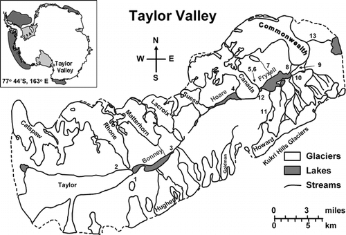
FIGURE 2. Stable isotope data collected from Taylor Valley, Antarctica, from December 1993 to January 1994 for (A) fresh snow, (B) snow pits, (C) glacier ice, and (D) stream water. Global meteoric water line (GMWL, defined as δD = 8 * δ18O + 10) and best fit linear regressions are also presented on each figure. Note: trend lines were purposely not drawn in so as to retain clarity in the figure
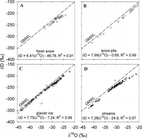
FIGURE 3. Snow-pit stable isotope profiles for Commonwealth (CW) and Howard (HW) Glaciers. δD profile data is a black line, δ18O profile data is represented as a dashed line

FIGURE 4. Glacier ice stable isotope data for Taylor Valley glaciers
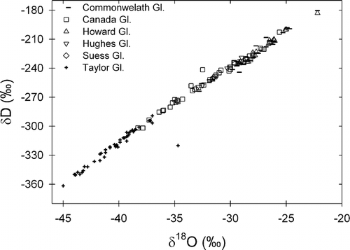
FIGURE 5. Taylor Valley stream water stable isotope data for (A) Lake Fryxell, (B) Lake Hoare, and (C) Lake Bonney basins, plotted by source glacier
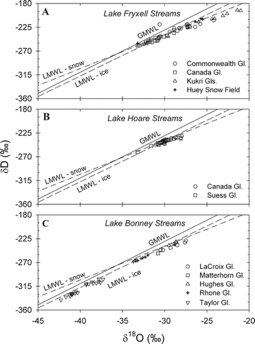
FIGURE 6. Stream water stable isotope data for (A) δ18O and (B) D-excess from 1993–1994 austral summer (solid circles) and 1999–2000 austral summer season (open squares). Symbols represent means of multiple samples, bars represent standard deviations. Solid bars represent the annual stream flow for 1993–1994 (black bars) and 1999–2000 (white bars). Note: Andrews Creek and McKnight Creek are not gauged
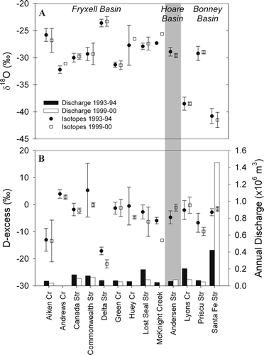
FIGURE 7. Relationship between stream length and stream water mean (A) δ18O ratio and (B) D-excess for 1993–1994 and 1999–2000 for each Taylor Valley lake basin
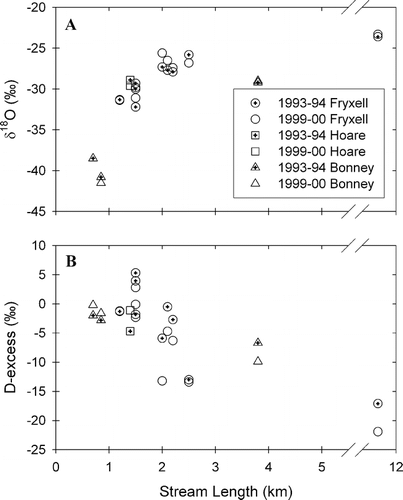
FIGURE 8. Taylor Valley lake δD profiles for (A) Lake Boney, (B) Lake Hoare, and (C, D) Lake Fryxell (broken into two figures for clarity). Data from 2002 collected for this study; 1972 Lake Bonney and Lake Fryxell data from CitationMatsubaya et al. (1979); 1990 and 1994 Lake Hoare data and 1992 and 1994 Lake Fryxell data from CitationLyons et al. (1998a); and 1987–1989 Lake Fryxell data from CitationMiller and Aiken (1996)
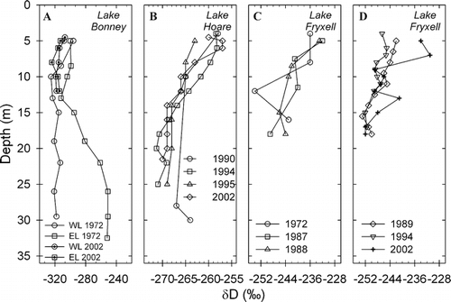
FIGURE 9. Taylor Valley lake D-excess profiles for (A) Lake Boney, (B) Lake Hoare, and (C) Lake Fryxell. Data from 2002 collected for this study; 1972 Lake Bonney and Lake Fryxell data from CitationMatsubaya et al. (1979); 1990 and 1994 Lake Hoare data from CitationLyons et al. (1998a); and 1987–1989 Lake Fryxell data from CitationMiller and Aiken (1996)

FIGURE 10. Semilog relationship between δ18O stable isotope values and Cl− concentrations in surface waters of Taylor Valley lakes. Data from 2002 collected for this study; 1972 Lake Bonney and Lake Fryxell data from CitationMatsubaya et al. (1979); 1990 and 1994 Lake Hoare and 1992 Lake Fryxell data from CitationLyons et al. (1998a)
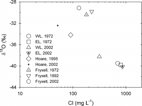
TABLE 1 Dry Valley stream lengths (to stream gauges, if they exist), originating glacier and lake basin
TABLE 2 Stable water isotope survey collection details. All samples analyzed for δD values, but not all analyzed for δ18O values
TABLE 3 Mean stable isotope values, standard deviations (in parentheses), and level of significance (assuming P < 0.005 suggests significant relationship) of difference between sample group means for a two-sample t-test assuming equal variances for data collected during the 1993–1994 season. No δ18O data collected for Lake Hoare or Lake Fryxell during 1993–1994 season
TABLE 4 Mean δ18O values (± standard deviation, for this work) of ice from Taylor Valley glaciers; n represents the number of samples analyzed
Acknowledgments
We would like to thank Harry House, Karen Lewis, Paul Langevin, and Tim Fitzgibbon for field assistance. Discussions with Eric Steig and Tom Neumann greatly aided our interpretation of the D-excess data. We are also grateful to James Hogan and one anonymous reviewer for constructive comments that greatly improved this paper. This work was funded by the McMurdo Dry Valleys Long Term Ecological Research Program through NSF grants OPP 9211773 and OPP 9810219.
Related Research Data
References Cited
- Alger, A. S. , D. M. McKnight , S. A. Spaulding , C. M. Tate , G. H. Shupe , K. A. Welch , R. Edwards , E. D. Andrews , and H. R. House . 1997. Ecological processes in a cold desert ecosystem: The abundance and species of algal mats in glacial meltwater streams in Taylor Valley, Antarctica. Boulder, Colorado: INSTAAR Occasional Paper no. 51.
- Bomblies, A. 1998. Climatic controls on streamflow generation from Antarctic glaciers,. Master's thesis, University of Colorado, Boulder, Colorado.
- Bomblies, A. , D. M. McKnight , and E. D. Andrews . 2001. Retrospective simulation of lake-level rise in Lake Bonney based on recent 21-yr record: indication of recent climate change in the McMurdo Dry Valleys, Antarctica. Journal of Paleolimnology 25:4 477–492.
- Chinn, T. J. 1993. Physical hydrology of the dry valley lakes. In Green, W. J., and Friedman, E. I. (eds.), Physical and Biogeochemical processes in Antarctic lakes. Antarctic Research Series, American Geophysical Union, Washington, DC, 1–51.
- Ciais, P. , J. W C. White , J. Jouzel , and J. R. Petit . 1995. The origin of present-day Antarctic precipitation from surface snow deuterium excess data. Journal of Geophysical Research—Atmospheres 100:D9 18917–18927.
- Clark, I. D. and P. Fritz . 1997. Environmental isotopes in hydrogeology. Boca Raton, Florida: CRC Press/Lewis Publishers, 328 pp.
- Clow, G. D. , C. P. McKay , G. M. Simmons , and R. A. Wharton Jr . 1988. Climatological observations and predicted sublimation rates at Lake Hoare, Antarctica. Journal of Climate 1:7 715–728.
- Conovitz, P. A. , D. M. McKnight , L. H. MacDonald , A. G. Fountain , and H. R. House . 1998. Hydrological processes influencing streamflow variation in Fryxell Basin, Antarctica. In Priscu, J. C. (ed.), Ecosystem Dynamics in a Polar Desert: The McMurdo Dry Valleys, Antarctica. Antarctic Research Series, American Geophysical Union, Washington, DC, 93–108.
- Cooper, L. W. , C. R. Olsen , D. K. Solomon , I. L. Larsen , R. B. Cook , and J. M. Grebmeier . 1991. Stable isotopes of oxygen and natural and fallout radionuclides used for tracing runoff during snowmelt in an Arctic watershed. Water Resources Research 27:9 2171–2179.
- Cooper, L. W. , C. Solis , D. L. Kane , and L. D. Hinzman . 1993. Application of oxygen-18 tracer techniques to Arctic hydrological processes. Arctic and Alpine Research 25:3 247–255.
- Craig, D. 1963. Isotopic variations in meteoric waters. Science 133:1702–1703.
- Dahe, Q. , J. R. Petit , J. Jouzel , and M. Steivenard . 1994. Distribution of stable isotopes in surface snow along the route of the 1990 international Trans-Antarctica expedition. Journal of Glaciology 40:134 107–118.
- Dansgaard, W. and H. Tauber . 1969. Glacier oxygen-18 content and Pleistocene ocean temperatures. Science 166:499–502.
- Doran, P. T. , J. C. Priscu , W. B. Lyons , J. E. Walsh , A. G. Fountain , D. M. McKnight , D. L. Moorhead , R. A. Virginia , D. H. Wall , G. D. Clow , C. H. Fritsen , C. P. McKay , and A. N. Parsons . 2002. Antarctic climate cooling and terrestrial ecosystem response. Nature 415:517–520.
- Doran, P. T. , J. C. Priscu , W. B. Lyons , R. Powell , D. Andersen , and R. Poreda . 2004. Paleolimnology of extreme cold terrestrial and extraterrestrial environments. In Pienitz, R., Douglas, M. S. V., and Smol, J. P. (eds.), Long-Term Environmental Change in Arctic and Antarctic Lakes. Dordrecht, The Netherlands: Kluwer Academic Publishers, 475–507.
- Epstein, S. and T. Mayeda . 1953. Variation of 18O content of waters from natural sources. Geochimica et Cosmochimica Acta 4:213–224.
- Epstein, S. and R. P. Sharp . 1959. Oxygen-isotope variations in the Malaspina and Saskatchewan glaciers. Journal of Geology 67:88–102.
- Fountain, A. G. , W. B. Lyons , M. B. Burkins , G. L. Dana , P. T. Doran , K. J. Lewis , D. M. McKnight , D. L. Moorhead , A. N. Parsons , J. C. Priscu , D. H. Wall , R. A. Wharton Jr , and R. A. Virginia . 1999. Physical controls on the Taylor Valley ecosystem, Antarctica. Bioscience 49:961–971.
- Fritz, P. , A. V. Morgan , U. Eicher , and J. H. McAndrews . 1987. Stable isotope, fossil Coleoptera and pollen stratigraphy in late Quaternary sediments from Ontario and New York State. Palaeogeography Palaeoclimatology Palaeoecology 58:3–4 183–202.
- Gooseff, M. N. , D. M. McKnight , W. B. Lyons , and A. E. Blum . 2002. Weathering reactions and hyporheic exchange controls on stream water chemistry in a glacial meltwater stream in the McMurdo Dry Valleys. Water Resources Research 38:12 1279. doi:1210.1029/2001WR000834.
- Gooseff, M. N. , D. M. McKnight , R. L. Runkel , and B. H. Vaughn . 2003. Determining long-timescale hyporheic zone flow paths in Antarctic streams. Hydrological Processes 17:1691–1710.
- Hall, B. L. and G. H. Denton . 2000. Radiocarbon chronology of Ross Sea drift, eastern Taylor Valley, Antarctica: evidence for a grounded ice sheet in the Ross Sea at the last glacial maximum:. Geografiska Annaler 82A:305–336.
- Hendy, C. H. , A. T. Wilson , K. B. Popplewell , and D. A. House . 1977. Dating of geochemical events in Lake Bonney, Antarctica, and their relation to glacial and climate changes. New Zealand Journal of Geology and Geophysics 20:1103–1122.
- Hood, E. M. , B. L. Howes , and W. J. Jenkins . 1998. Dissolved gas dynamics in perennially ice-covered Lake Fryxell, Antarctica. Limnology & Oceanography 43:2 265–272.
- Hooper, R. P. and C. A. Shoemaker . 1986. A comparison of chemical and isotopic hydrograph separation. Water Resources Research 22:10 1444–1454.
- House, H. R. , D. M. McKnight , and P. von Guerard . 1995. The influence of stream channel characteristics on streamflow and annual water budgets for lakes in Taylor Valley. Antarctic Journal of the United States 30:5 284–287.
- Karim, A. and J. Veizer . 2000. Weathering processes in the Indus River Basin: implications from riverine carbon, sulfur, oxygen, and strontium isotopes. Chemical Geology 170:1–4 153–177.
- Kavanaugh, J. L. and K. M. Cuffey . 2002. Generalized view of source-region effects on δD and deuterium excess of ice-sheet precipitation. Annals of Glaciology 35:111–117.
- Kavanaugh, J. L. and K. M. Cuffey . 2003. Space and time variation of δ18O and δD in Antarctic precipitation revisited. Global Biogeochemical Cycles, 17(1): art. no. 1017.
- Lewis, K. A. , A. G. Fountain , and G. L. Dana . 1999. How important is terminus cliff melt?: A study of the Canada Glacier terminus, Taylor Valley, Antarctica. Global Planetary Change 22:105–115.
- Lorrain, R. , S. Sleewaegen , S. Fitzsimons , and M. Stiévenard . 2002. Ice formation in an Antarctic glacier-dammed lake and implications for glacier-lake interactions. Arctic, Antarctic, and Alpine Research 34:2 150–158.
- Lyons, W. B. , S. W. Tyler , R. A. Wharton Jr , D. M. McKnight , and B. H. Vaughn . 1998a. A late Holocene desiccation of Lake Hoare and Lake Fryxell, McMurdo Dry Valleys, Antarctica. Antarctic Science 10:247–256.
- Lyons, W. B. , K. A. Welch , K. Neumann , J. K. Toxey , R. McArthur , C. Williams , D. M. McKnight , and D. Moorhead . 1998b. Geochemical linkages among glaciers, streams and lakes within the Taylor Valley, Antarctica. In Priscu, J. C. (ed.), Ecosystem Dynamics in a Polar Desert: The McMurdo Dry Valleys, Antarctica. Washington, DC: American Geophysical Union, 77–92.
- Lyons, W. B. , K. A. Welch , A. G. Fountain , G. L. Dana , B. H. Vaughn , and D. M. McKnight . 2003. Surface glaciochemistry of Taylor Valley, southern Victoria Land, Antarctica and its relationship to stream chemistry. Hydrological Processes 17:115–130.
- Matsubaya, O. , H. Sakai , T. Torii , H. Burton , and K. Knowles . 1979. Antarctic saline lakes—stable isotopic ratios, chemical compositions and evolution. Geochimica et Cosmochimica Acta 43:7–25.
- Mayewski, P. A. , W. B. Lyons , G. Zielinski , M. Twickler , S. Whitlow , J. Dibb , P. Grootes , R. Taylor , P. Y. Whung , L. Fosberry , C. Wake , and K. Welch . 1995. An ice core based Holocene history for the Transantarctic Mountains, Antarctica. Antarctic Research Series. Washington, DC: American Geophysical Union, Contributions to Antarctic Research IV, Vol. 67: 33–45.
- McKnight, D. M. and E. D. Andrews . 1993. Hydrologic and geochemical processes at the stream-lake interface in a permanently ice-covered lake in the McMurdo Dry Valleys, Antarctica. Verhandlungen der Internationalen Vereinigung für Theoretische und Angewandte Limnologie 25:957–959.
- McKnight, D. M. , D. K. Niyogi , A. S. Alger , A. Bomblies , P. A. Conovitz , and C. M. Tate . 1999. Dry Valley streams in Antarctica: ecosystems waiting for water. Bioscience 49:12 985–995.
- McNamara, J. P. , D. L. Kane , and L. D. Hinzman . 1997. Hydrograph separations in an Arctic watershed using mixing model and graphical techniques. Water Resources Research 33:7 1707–1719.
- Miller, L. G. and G. R. Aiken . 1996. Effects of glacial meltwater inflows and moat freezing on mixing in an ice-covered Antarctic lake as interpreted from stable isotope and tritium distributions. Limnology & Oceanography 41:5 966–976.
- Noone, D. and I. Simmonds . 2004. Sea ice control of water isotope transport to Antarctica and the implications for ice core interpretation. Journal of Geophysical Research, 109: do70105, doi:10.1029/2003JD004228.
- Petit, J. R. , J. W C. White , N. W. Young , J. Jouzel , and Y. S. Korotkevich . 1991. Deuterium excess in recent Antarctic snow. Journal of Geophysical Research 96:D3 5113–5122.
- Poreda, R. J. , A. G. Hunt , W. B. Lyons , and K. A. Welch . 2004. The helium isotopic chemistry of Lake Bonney, Taylor Valley, Antarctica: Timing of late Holocene climate change in Antarctica. Aquatic Geochemistry 10:3–4 353–371.
- Runkel, R. L. , D. M. McKnight , and E. D. Andrews . 1998. Analysis of transient storage subject to unsteady flow: diel flow variation in an Antarctic stream. Journal of the North American Benthological Society 17:143–154.
- Satake, H. and K. Kawada . 1997. The quantitative evaluation of sublimation and the estimation of original hydrogen and oxygen of a firn core at East Queen Maud Land, Antarctica. Bulletin of Glacier Research 15:93–97.
- Siegenthaler, U. and H. Oeschger . 1980. Correlation of 18O in precipitation with temperature and altitude. Nature 285:314–317.
- Spiegel, R. H. and J. C. Priscu . 1998. Physical limnology of the McMurdo Dry Valleys lakes. In Priscu, J. C. (ed.), Ecosystem Processes in a Polar Desert. Washington, DC: American Geophysical Union, 153–187.
- Steig, E. J. , E. J. Brook , J. W C. White , C. M. Sucher , M. L. Bender , S. J. Lehman , E. D. Waddington , D. L. Morse , and G. D. Clow . 1998. Synchronous climate changes in Antarctica and the North Atlantic. Science 282:92–95.
- Steig, E. J. , D. L. Morse , E. D. Waddington , M. Stuiver , P. M. Grootes , P. A. Mayweski , M. S. Twickler , and S. I. Whitlow . 2000. Wisconsinan and Holocene climate history from an ice core at Taylor Dome, western Ross embayment, Antarctica. Geografiska Annular 82A:213–232.
- Stewart, M. K. and J. J. McDonnell . 1991. Modeling base flow soil water residence times from deuterium concentrations. Water Resources Research 27:10 2681–2693.
- Stichler, W. and U. Schotterer . 2000. From accumulation to discharge: modification of stable isotopes during glacial and post-glacial processes. Hydrological Processes 14:8 1423–1438.
- Stuiver, M. , I. C. Yang , G. H. Denton , and T. B. Kellogg . 1981. Oxygen isotope ratios of Antarctic permafrost and glacier ice. In McGinnis, L. D. (ed.), Dry Valley Drilling Project. Antarctic Research Series, 33: 131–140.
- Theakstone, W. H. 1988. Temporal variations of isotopic composition of glacier-river water during summer: observations at Sustre Okstindbreen, Okstindan, Norway. Journal of Glaciology 34:118 309–317.
- Theakstone, W. H. and N. T. Knudsen . 1989. Temporal changes of glacier hydrological systems indicated by isotopic and related observations at Austre Okstindbreen, Okstindan, Norway, 1976–87. Annals of Glaciology 13:252–256.
- Theakstone, W. H. and N. T. Knudsen . 1996. Isotopic and ionic variations in glacier river water during three contrasting ablation seasons. Hydrological Processes 10:523–539.
- Turner, J. V. , D. K. Macpherson , and R. A. Stokes . 1987. The mechanisms of catchment flow processes using natural variations in deuterium and oxygen-18. Journal of Hydrology 94:143–162.
- Vaughn, B. H. , J. W C. White , M. Delmotte , M. Trolier , O. Cattani , and M. Stievenard . 1998. An automated system for hydrogen isotope analysis of water. Chemical Geology 152:Isotope Geoscience Section 309–319.
- Vimeux, F. , V. Masson , G. Delaygue , J. Jouzel , J. R. Petit , and M. Stievenard . 2001. A 420,000 year deuterium excess record from East Antarctica: Information on past changes in the origin of precipitation at Vostok. Journal of Geophysical Research—Atmospheres 106:D23 31863–31873.
- von Guerard, P. , D. M. McKnight , R. A. Harnish , J. W. Gartner , and E. D. Andrews . 1995. Streamflow, water-temperature, and specific-conductance data for selected streams draining into Lake Fryxell, Lower Taylor Valley, Victoria Land, Antarctica, 1990–92. U. S. Geological Survey Open-File Report, 94-0545: 65 pp.
- Welch, K. A. 1993. Glaciochemical Investigations of the Newall Glacier, Southern Victorialand Antarctica. Master's thesis, University of New Hampshire, 92 pp.
- Welch, K. A. , P. A. Mayewski , and S. I. Whitlow . 1993. Methanesulfonic-acid in coastal Antarctic snow related to sea-ice extent. Geophysical Research Letters 20:6 443–446.
- Welch, K. A. , K. Neumann , D. M. McKnight , A. G. Fountain , and W. B. Lyons . 2000. Chemistry and lake dynamics of the Taylor Valley Lakes, Antarctica: The importance of long-term monitoring,. In Davison, W., Howard-Williams, C., and Broady, P. (eds.), Antarctic Ecosystems: Models for Wider Ecological Understanding. Christchurch, New Zealand: New Zealand Natural Sciences, 282–287.