ABSTRACT
Understanding trophic interaction within deep-sea marine communities is critically important as commercial exploitation increases in the Arctic. Undoubtedly, the Arctic marine environment will be subject to the same environmental and human stressors as its southern counterparts and, as a result, community stability is vulnerable. The objectives of this study were to test the predictive power of environmental variables on fish community composition using redundancy analysis and to determine if this information could be used to differentiate distinct trophic communities throughout the Davis Strait/Baffin Bay region. This analysis used data collected in benthic surveys from 2000 to 2004, and results indicate that water temperature, latitude, and depth strongly influence the distribution of fish species in this region. Latitude and water temperature were strongly negatively correlated, and the majority of species were distributed along the low latitude/high temperature to high latitude/low temperature gradient. Some fish species were more highly correlated with depth. Proportions of most by-catch species differed between northern and southern regions at each depth range. Since community structure changes gradually along environmental gradients, perhaps it is more appropriate to describe the communities as shifting their trophic status along environmental gradients rather than as distinct communities with distinct food webs in a specific region of the Arctic.
Introduction
Efforts to exploit Arctic marine fisheries are increasing as landings of the world's marine fisheries have plateaued and for some species catches have declined (CitationHutchings and Myers, 1995; CitationZhao et al., 2003). The Arctic Ocean is heterogeneous due in part to latitude, variability in ocean currents, salinity, and depth, indicating that marine fish populations will likely vary both regionally and locally. Eight ecoregions have been designated for the Canadian Arctic compared to six for the Pacific region and seven for the Atlantic region (CitationPowles et al., 2004). Consequently, the need to know how Arctic marine fish communities are structured overall and locally is essential for long-term sustained fisheries. Research in these areas is relatively recent and has focused on commercially important species such as Greenland halibut (Reinhardtius hippoglossoides) (CitationTreble, 2002; CitationTreble et al., 2000, Citation2001). By-catch species and their role in ecosystem dynamics have been largely overlooked. Past exploitation indicates that effective management decisions require an understanding of the biological and ecological processes that drive community dynamics. Food webs are traditionally used for this purpose; however, they are often incomplete and do not account for factors such as changes in trophic status with body size, latitude, and/or depth.
In 1999, the Department of Fisheries and Oceans Canada (DFO) launched their Greenland Halibut Arctic Survey, an ongoing project aimed at investigating Greenland halibut populations throughout Davis Strait and Baffin Bay. Their secondary objective was to survey by-catch populations in order to discern which species represent important prey items and/or competitors of Greenland halibut.
The objective of this project was to investigate the role of environmental variables on marine fish community composition using multivariate analytical methods in order to predict changes in trophic structure within the Davis Strait/Baffin Bay region. More specifically, the goals were (1) to determine if environmental variables could be used to predict fish species composition along Davis Strait and Baffin Bay, and (2) to ascertain if this information is applicable to the construction of Arctic food webs.
Methods
Sampling Area
This project was conducted in conjunction with the Greenland Halibut Otter Trawl Survey in the North Atlantic Fisheries Organization (NAFO) Subareas 0 and 1. It was a cooperative project of the University of Manitoba Department of Zoology, Fisheries and Oceans Canada, Greenland Institute of Natural Resources, University of Copenhagen, Nunavut Wildlife Management Board, and Baffin Island communities adjacent to the survey locations.
Between September and November 2000–2004, NAFO surveyed subareas 0 (divisions A and B) and 1 (divisions A, C, and D) located between 61 and 75°N, and 75 and 55°W within Davis Strait and Baffin Bay (). Samples were collected using an A722 GRT stern trawler (MV Paamiut) equipped with an Alfredo III bottom otter trawl with rock hopper ground gear (CitationTreble et al., 2000). Mesh size was 140 mm with a 30 mm mesh liner in the cod end. Each subarea was divided into eight depth strata, and transects were randomly chosen from each (CitationBowering, 1987; CitationTreble et al., 2000, Citation2001). Samples were collected from 318 randomly preselected tows (depths from 400 to 1500 m and temperatures from −1 to 4°C). At each tow, environmental and biological data were collected including geographical position (latitude and longitude), tow length (distance and time), depth, bottom temperature, and species data (total weight and number of each species). Trawling occurred over a 24-hour period with maximum tow duration of 30 minutes. Average towing speed was 3.0 kn.
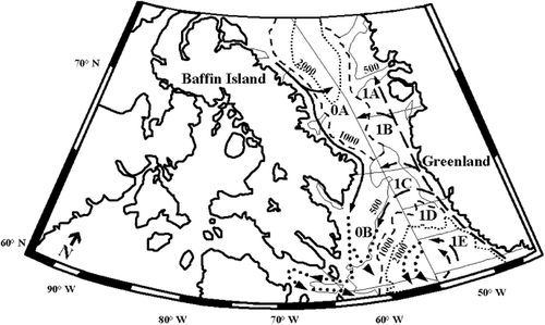
Figure 1 Map of North Atlantic Fisheries Organization (NAFO) management areas within Baffin Bay and Davis Strait. Data used for analysis were collected from 0A, 1A, 0B, 1C, and 1D between 2000 and 2004. Of the current flows through NAFO management areas within Baffin Bay and Davis Strait, dashed arrows represent warmer waters of the West Greenland Current, solid arrows indicate colder waters of the Polar Current, and dotted arrows represent the moderate Labrador Current.
Data Analysis
Data collected from tows in the 2000–2004 surveys were used in this analysis. Four environmental variables were chosen for comparison with abundances of 145 fish species (), including distance measures of latitude and longitude, bottom depth, and water temperature. Latitude and longitude coordinates were converted to northing and easting UTM (Universal Transverse Mercator) distance measures using the conversion software GeoTrans2 (CitationNorthrop Grumman Information Technology, 2002). Easting values were further converted to make distance measures comparable to each other by calculating the distance west of each transect from the midpoint of UTM zone 23. Fish abundance for each tow was logged and organized into a covariance matrix in order to avoid giving equal weights to both abundant and rare species. Environmental data for each tow was also logged and standardized in a correlation matrix. Redundancy analysis (RDA) of environmental data with species abundance was run using the statistical software CANOCO 4.53.
Table 1 List of species found within Davis Strait and Baffin Bay in 2000–2004 surveys.
Results and Discussion
RDA results in show that 42.2% of the total redundancy in species abundance is predicted from variation in the environment. Eigenvalues (E) and the cumulative proportion of canonical variance accounted for by each canonical axis (CSE) indicate that most of the variation is accounted for in the first two axes with E values of 0.321 and 0.071 and CSE values of 76.0 and 92.8%, respectively.
Table 2 Total redundancy in species that is predicted from variation in the environment, eigenvalues (E), and cumulative proportion of canonical variance (CSE) accounted for by each canonical axis in the redundancy analysis (RDA).
Scatterplot results () illustrate how species data is constrained by the environmental data. Temperature and latitude are negatively correlated along RDA Axis 1 indicating that community composition differs between high latitude areas with low temperatures and low latitude areas with higher temperatures. Longitude is also negatively correlated with temperature but less so than latitude as indicated by its shorter vector length. Depth also influences community composition and is accounted for along RDA Axis 2.
Figure 2 Scatterplot results from redundancy analysis (RDA) of fish abundance and environmental data. Mb: M. berglax; Ar: A. rostrata; Cr: C. rupestris, S. kaupi; Sme: S. mentella; Aa: A. atlanticus, B. saida, L. fabricii; Rah: R. hyperborea; Pb: P. bathybius.
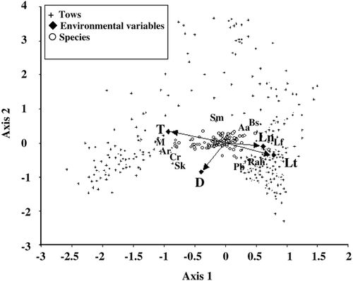
Sampling of benthic marine Arctic habitats revealed that the distribution of fish species differed within and between subareas and, consequently, the Davis Strait/Baffin Bay region may be composed of several “distinct” communities. Although many species remain common throughout the study area, several others appear to vary in abundance. Redundancy analysis comparing fish species abundance with environmental variables supports this theory and provides an explanation as to why changes in community structure occur. Scatterplot results in indicate that species with low LC scores, i.e. those species closest to the origin of the ordination, are not significantly correlated with any of the four environmental variables, suggesting they remain ubiquitous throughout Arctic waters regardless of environmental change. Reexamination of the raw data confirms that these fish remained relatively abundant throughout the study area and may be considered “core” species (e.g. Greenland halibut, polar sculpin), whereas others are relatively rare (e.g. Greenland shark [Somniosus microcephalus]). Several species, many of which represent key predators or prey, vary along environmental gradients such as depth, temperature, and/or latitude. The presence or absence of these species, or “variants,” within deep-sea environments may affect shifts in the trophic status of many individuals, effectively altering the community dynamic.
The present study corroborates findings of CitationJorgensen et al. (2005). M. berglax, A. rostrata, C. rupestris, and S. kaupi were closely associated with each other in low latitude/high temperature areas, whereas A. atlanticus, L. fabricii, and B. saida were most closely associated with high latitude/low temperature areas (). Differences in depth were also comparable to CitationJorgensen et al. (2005). For example, S. mentella was most closely associated with shallow waters and more strongly correlated with low latitude/high temperature areas, whereas species such as P. bathybius and R. hyperborea were more closely associated with deep waters and high latitude/low temperature areas.
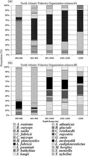
illustrates the proportional differences (by number) of 20 common by-catch species in 5 depth ranges within NAFO subareas 0A and 0B between 2000 and 2001. In subarea 0A B. saida dominated in shallow waters, whereas S. mentella had the highest proportion at the same depths in 0B. Two species dominated in tows greater than 600 m within subarea 0A, the most abundant of which was the snailfish L. fabricii. Rocklings (G. ensis) also dominated these tows and increased in proportion with increasing depth. The increase of G. ensis corresponded to a decrease of L. fabricii. In 0B, more species were present overall, and no single species dominated at depths greater than 800 m. S. kaupi and A. rostrata were absent from 0A but showed a definite increase in proportion with depth in 0B. Lanternfish L. macdonaldi and B. glaciale decreased in proportion with increasing depth in 0B. Though G. ensis represented a lower proportion of the by-catch overall in subarea 0B, it followed a similar pattern to that of 0A in terms of increasing proportion with increasing depth.
Figure 3 Proportion of 20 most common by-catch species within (a) NAFO subarea 0A and (b) NAFO subarea 0B between 2000 and 2001.
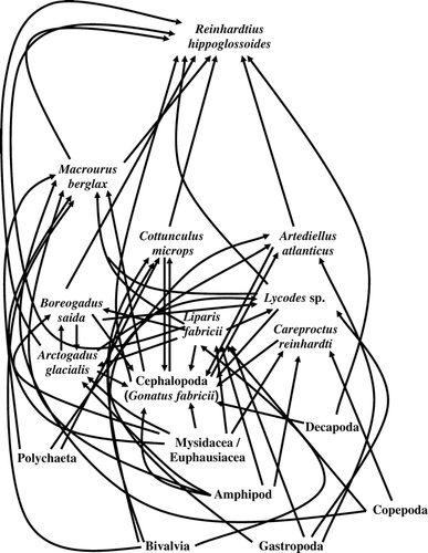
Communities in higher Arctic latitudes differ from their southern counterparts in that organisms such as lanternfish (L. macdonaldi) and grenadier (C. rupestris) begin to reach the limits of their geographic distribution. As their abundance declines, other species such as L. fabricii and G. ensis become more important within the community as predator and prey species. Consequently, species interactions and food web structure are altered and certain species may replace others in terms of trophic importance. and demonstrate this shift in community dynamics, illustrating important differences in food web structure between northern (0A) and southern (0B) communities. Fish species at each trophic level are lost further north (0A), including important predator and prey species such as S. kaupi, C. fabricii, A. rostrata, C. rupestris, and B. euryops. As expected, some species are replaced by others of a similar trophic level (e.g. A. glacialis, C. reinhardti); however, the number of species and linkages decreases overall.
Figure 4 Generalized partial food web of NAFO subarea 0B representing common predator and prey species based on stomach content data from 2000–2001 samples.
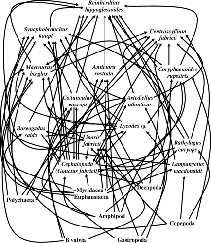
Figure 5 Generalized partial food web of NAFO subarea 0A representing common predator and prey species based on stomach content data from 2000–2001 samples.
According to RDA results, longitude has less influence on community composition than the temperature/latitude gradient; however, it remains an important descriptor of community structure in terms of changes in current flow and physical characteristics of the ocean bottom (CitationTang et al., 2004). For example, shelf length on the Canadian side of Baffin Bay/Davis Strait is shorter than that on the Greenland side (CitationTang et al., 2004). Consequently, the distribution of deep- and shallow-water species at similar latitudes will differ in accordance with shelf association at different longitudes. This pattern was also noted by CitationJorgensen et al. (2005). The Davis Strait/Baffin Bay region is unique in that it is subject to several current systems, each with a different temperature and direction of flow (CitationJones et al., 2003; CitationKiilerich, 1939; CitationTang et al., 2004). For example, the West Greenland Current (WGC) flows south-to-north along the eastern portion of this region, exposing species to warm, northerly flowing waters. Conversely, the Polar Current (PC) flows in a north-to-south direction, exposing species on the western side of Davis Strait and Baffin Bay to colder Arctic waters (). Two such different current systems in a relatively small geographical area have been theorized to produce two separate and distinct ecological communities; one with more warm-tolerant species and the other with more cold-tolerant species. The absence of significant differences between these two areas may be explained by a high degree of current “mixing” within this relatively narrow region, resulting in areas more similar in terms of environmental conditions than previously thought. For example, as the WGC travels north, warm water “branches off” from the main direction of flow to circulate and mix with the colder waters to the west. Similarly, as the PC travels south, its colder waters mix with the warmer eastern waters to a certain extent (). As a result, the temperature gradient is less from east to west than from south to north, and species composition remains similar. Though the effects of current movement may have an important impact on species distribution in relatively shallow waters (i.e. <800 m), temperature and salinity are known to stabilize and remain relatively uniform at greater depths (CitationTang et al., 2004). Consequently, species distribution at greater depths will not be affected as significantly.
Conclusions
Redundancy analysis confirmed that approximately 42% of species distribution can be predicted using a combination of four environmental variables (latitude, longitude, temperature, and depth). As latitude increases, proportions of by-catch species at depth change drastically. As species are lost from the system, predators become increasingly dependent on the remaining organisms to meet daily dietary requirements, and the removal or depletion of a common food source could result in partial or complete collapse of the system. With this information, it is now possible to predict community composition in different areas along the Davis Strait/Baffin Bay and to construct food webs representative of these communities. Because community structure appears to change gradually along environmental gradients, it may prove difficult to separate out distinct trophic communities and construct a corresponding food web for each. Alternatively, it may be more useful to describe the region in terms of shifting trophic status with assemblage along the temperature/latitude and depth gradients rather than attempt to construct several different food webs that may not encompass all of the variation seen in this dynamic environment.
Acknowledgments
Research was supported by the NSERC Northern Research Chair, Department of Fisheries and Oceans Subvention Grant; NSERC Operating Research Grant to T. A. Dick; NSERC Northern Scientific Training Program financial support to C. Chambers. We thank Colin Gallagher for the technical contributions to the manuscript. We thank the Department of Fisheries and Oceans Canada for ship time and Dr. Michael Papst, Margaret Treble, Rick Wastle, and Martin Curtis for advice relating to this research. Thanks also to Dr. N. Kenkel for statistical advice.
Related Research Data
References Cited
- Bowering, W. R. 1987. Distribution and abundance of Greenland halibut in Davis Strait (NAFO subareas 0 and 1) from a Canadian research vessel survey in 1986. NAFO SCR Document 87/22, Series No. N1305 1–10.
- Hutchings, J. A. and R. A. Myers . 1995. The biological collapse of Atlantic cod off Newfoundland and Labrador: an exploration of historical changes in exploration, harvesting technology, and management. In Arnason, R. and L. Felt , editors. eds. The North Atlantic Fisheries: Successes, Failures, and Challenges. Volume 3 of An Island Living Series (B. Bartmann, ed.) Charlottetown The Institute of Island Studies. 37–93.
- Jones, E. P. , J. H. Swift , L. G. Anderson , G. Lipizer , M. G. Civitarese , and K. K. Falkner . 2003. Tracing Pacific water in the North Atlantic Ocean. Journal of Geophysical Research 108:13 1–10.
- Jorgensen, O. A. , C. Hvingel , P. R. Moller , and M. A. Treble . 2005. Identification and mapping of bottom fish assemblages in Davis Strait and southern Baffin Bay. Canadian Journal of Fisheries and Aquatic Sciences 62:1833–1852.
- Kiilerich, A. B. 1939. The Godthaab Expedition 1928—A theoretical treatment of the hydrographical observation material. Meddelelser om Grønland 78:5 1–148.
- Northrop Grumman Information Technology 2002. Geographic Translator (GEOTRANS) Version 2.2.2. Beeches Technical Campus,. Rome, New York Northrop Grumman Information Technology.
- Powles, H. , V. Vendette , R. Siron , and R. O'Boyle . 2004. Proceedings of the Canadian Marine Ecoregions Workshop Ottawa Fisheries and Oceans Canadian Science Advisory Secretariat Proceedings. Series 2004/016. 1–42.
- Tang, C. C. L. , C. K. Ross , T. Yao , B. Petrie , B. M. DeTracey , and E. Dunlap . 2004. The circulation, water masses and sea-ice of Baffin Bay. Progress in Oceanography 63:183–228.
- Treble, M. A. 2002. Analysis of data from the 2001 Trawl Survey in NAFO subarea 0. NAFO SCR Document 02/47, Series No. N4659 1–29.
- Treble, M. A. , W. B. Brodie , W. R. Bowering , and O. A. Jorgensen . 2000. Analysis of data from a trawl survey in NAFO Division 0A, 1999. NAFO SCR Document 00/31, Series No. N4260 1–19.
- Treble, M. A. , W. B. Brodie , W. R. Bowering , and O. A. Jorgensen . 2001. Analysis of data from a trawl survey in NAFO Division 0B, 2000. NAFO SCR Document 01/42, Series No. N4420 1–19.
- Zhao, X. , J. Hamre , F. Li , X. Jin , and Q. Tang . 2003. Recruitment, sustainable yield and possible ecological consequences of the sharp decline of the anchovy ( Engraulis japonicus ) stock in the Yellow Sea in the 1990s. Fisheries Oceanography 12:4/5 495–501.