ABSTRACT
Environmental impact assessments in Brazil have usually focused solely on project-related issues without considering the regional context. Although required by current environmental legislation, cumulative impact assessments have not been included in the overall environmental assessment of projects. However, in recent Strategic Environmental Assessment (SEA) studies of policies, plans, and programs undertaken on a voluntary basis in support of the decision-making process, this kind of assessment has been performed especially with respect to air quality. This paper presents the application of a methodology for the quantification of cumulative impacts on air quality under high uncertainty caused by various mining activities in a single region that is recommended for SEA studies. In this way, the methodology presented here is suitable for areas lacking detailed modeling information. The developed approach uses a relatively simplified mathematical model, lowering information gathering costs and requiring little processing time. The application of the methodology is illustrated in the case of a SEA of the Corumbá Mining and Industrial Complex Development Program. Despite the lack of data needed for a minimum characterization of conditions of the area surrounding the region modeled, the quantification of impact cumulativeness on air quality has played an important role in the context of the SEA.
The importance in the Brazilian context of the analysis of cumulativeness in environmental impact assessments has become increasingly evident to some public and private stakeholders who have begun to discuss the issue thanks to SEA studies. This paper presents an alternative methodology to conduct quantitative analysis of cumulative impacts on air quality, requiring less detailed field data while using a less complex, but usually conservative, mathematical model of atmospheric pollutant dispersion. The developed approach provides support for decision-making, enabling policy-makers to discuss strategic options in the formulation of programs, plans, and policies in these cases with potentially high uncertainty.
INTRODUCTION
In Brazil, the Environmental Impact Assessment (EIA), although created to be a wide-ranging national environmental policy instrument,Citation1 has, in practice, been applied mainly at the project level. Experience with its application has suggested the need to broaden its scope for use during the environmental planning phase.
In accordance with trends observed in other countries, not only the government but also other stakeholders have encouraged the adoption of EIAs as an environmental management tool to bridge the gap between the overall plans drawn up for a specific region and the individual installation of each project included in the plans.
Although sharing the same roots, the Strategic Environmental Assessment (SEA) of policies, plans, and programs and the EIA of projects differ in terms of their goals. The SEA assesses development strategies and involves a high degree of uncertainty. The EIA assesses concrete proposals and measures for project execution.Citation2–11 However, these tools are complementary because the formulation of policies, plans, and programs is followed by the projects necessary for their implementation.
According to the environmental legislation in force, projects of potentially polluting activities have to undergo an EIA to obtain the respective environmental permits. In this context, the studies that have been performed to date only consider the environmental impact of individual projects without any overall analysis of existing undertakings or those forecast for a given region; that is, there is no assessment of cumulative and synergistic effects.
Thus, despite the existence of a legal basis, its effects, in practice, have not been considered by environmental studies.Citation12
This historical record in Brazil illustrates that assessments undertaken for isolated projects do not ensure the intended balance among environmental, economic, and social aspects of development.
The importance of the analysis of cumulativeness and synergy in the Brazilian context has become increasingly evident to some public and private stakeholders, who have already begun to discuss the issue thanks to SEA studies. The Ministry of the Environment took the initiative in this field, establishing some of SEA's conceptual elements to guide its use in government planning processes.
The Environmental Sciences Laboratory (LIMA) of the Energy Planning Program of Alberto Luiz Coimbra Institute of Post-Graduate Studies and Research in Engineering (COPPE), of the Federal University of Rio de Janeiro (UFRJ) has developed methodologies and prepared some SEAs of government and private-sector plans and programs in which emphasis has been placed on synergistic and cumulative aspects.
This article presents the discussions regarding methodology, tools, results achieved, and difficulties faced in the assessment of cumulative impacts on air quality illustrated by its application in the SEA of the Corumbá Mining and Industrial Complex Development Program, which is located in the Pantanal Wetland region of the State of Mato Grosso do Sul, Brazil.
METHODOLOGY
The assessment of the cumulativeness of emissions caused by mining activities was undertaken in the context of the Corumbá Mining and Industrial Complex Development Program and the involved mining companies that operate in the region.
The report first described the characteristics of the area studied and its surroundings, Urucum Massif on the Western Rim of the Pantanal Wetlands and the entire Pantanal Wetlands plain. It then identified the current production capacity of each of the five companies involved and their respective development programs as well as the situation of the mining research and production permit and environmental licensing procedures. This was followed by a survey of the meteorological data available for the region to identify predominant wind patterns and their variations throughout the year. An assessment was also made of the reliability of existing environmental quality monitoring data available for use in the study. LIMA adopts the design of scenarios in its methodological approach for future projections undertaken in the development of SEAs. A fundamental part of SEA studies is the prospective view of the consequences of the strategical actions because it may offer some orientation toward decision-making according to the principles of environmentally sustainable development of the society. For that, the scenario formulation method has been consolidated as one of the main technical tools once it allows that probable results be evaluated as well as a behavior in complex system, of hard understanding or that be associated with them, a high level of uncertainty inherent to this kind of forecast.
Scenarios are descriptions, stories of the future that are coherent, internally consistent, and plausible. They do not constitute precise forecasts but are rather sensible pictures that are based on given assumptions. Each scenario is an image and a trajectory of what the future may look like and is useful to show how different assumptions may influence future conditions in a given system.Citation13 This way, scenarios allow an integrated analysis that is important to identify the interactions in the development vectors and environmental factors as well as to identify opportunities and elements that may ease the negotiation.
Scenarios may be used to illustrate future changes, communicate the potential consequences of planned actions, lead policies, or meet specific methodological goals in such a way that more probable alternatives be anticipated, the actions organized, and investments oriented with the perspective of optimizing the results and favoring the construction of the alternative futures upon which decisions are made.
Two scenarios were defined for the Pantanal SEA on the basis of the environmental requirements imposed by the government for the installation and expansion of mining activities in the region covered by the study. Different air quality models available and applicable to quantify cumulative impacts in a SEA were assessed to define the most appropriate tool, according to the defined indicator, total suspended particulates (TSP), and to the SEA's scenarios. It was decided to use TSP as an indicator of the impact of mining activities on air quality because particulate matter (PM) is the characteristic pollutant of these activities' emissions. In Brazil, the current environmental legislator states air quality standards for short- and long-term TSP, and it has been the most monitored pollutant in the community. This is mostly because of the high costs of the equipment: the HiVol TSP sampler costs around U.S.$4,000, the HiVol PM10 (PM ≤ 10 μm in aerodynamic diameter) sampler costs around U.S.$16,000, and the HiVol PM2.5 (PM ≤ 5 μm in aerodynamic diameter) sampler costs around U.S.$18,000. Moreover, the HiVol PM10 and PM2.5 sampler operator is much more expensive and requires operators who are more skilled than the ones who operate HiVol TSP sampler. This way, taking into account the condition of the country, it is more realistic to set as indicator the TSP kind for air dust level once this parameter is more likely to be monitored.
A mathematical modeling technique was selected to measure impacts on the basis of the emissions of the mining area. Using only a 1-yr series of Corumbá Airport's hourly meteorological data for the simulation, the pollution dispersion simulation study was undertaken with the aid of the Industrial Source Complex (ISC3) dispersion model developed and recommended by the U.S. Environmental Protection Agency (EPA).
The practice of SEA in Brazil is still very incipient and diverse, having been applied, most of the times, in a volunteer feature. The ISC3 model was chosen for being more conservative and for its higher simplicity in the input data and processing rather than more refined models such as AERMOD, CALPUFF, or SCIPUFF.
The Corumbá region is extremely poor in hourly meteorological observation data. There is only one station with capacity for accomplishing this kind of monitoring at Corumbá Airport, and its information has as a main goal to support the local flight protection system. The set of data is insufficient and discontinuous, hindering the elaboration of consistent historical data. The year 2004 was selected for presenting the most complete set of information required by the dispersion model among all of the available set.
The information in this file was carefully compared with the historical series of 30 yr in the Climatology Normal of the Conventional Meteorological Station from the National Meteorology Institute. It was verified that the year 2004 used in the studies does not have abnormalities in the meteorological parameter values when compared with long-term historical data. Therefore, this meteorological time series may safely be considered representative of normal meteorological conditions in the region.
The results were then assessed, and estimated TSP values were transformed into annual averages to compare them with the legal air quality standard of 80 μg/m3,which was established for the protection of human health.Citation14 On the basis of these results it was possible to draw SEA conclusions that provided support for decision-makers regarding the growth of the mining sector in the region.
This paper undertakes a critical assessment of the procedures adopted and difficulties encountered in the SEA, focusing especially on data quality, the application of the selected mathematical model, and discussing the possibilities for methodological improvements that could benefit future studies.
The recommendations made at the end of the article draw on the experience, in the context of a SEA, of the analysis of air pollutant cumulativeness in mining activities in the environmentally sensitive Mato Grosso Pantanal Wetland region using mathematical modeling tools.
CHARACTERIZATION OF THE REGION
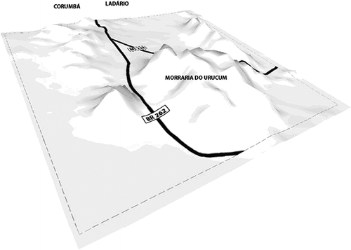
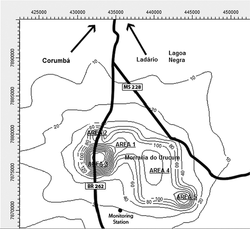
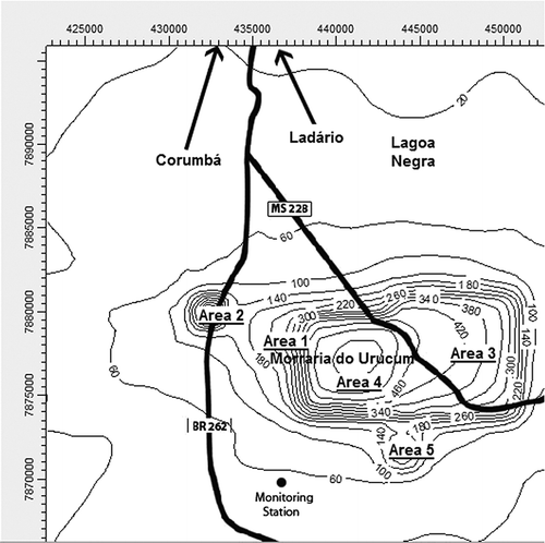
The Pantanal Wetland plain, a huge area that is periodically flooded by the Paraguay River, is the Earth's largest tropical humid area. The Pantanal Wetlands were declared a National Patrimony by the Federal Constitution in 1988. The site was designated by the Ramsar Humid Areas Convention in 1993 and as a biosphere Reserve by the U.N. Educational, Scientific, and Cultural Organization in the year 2000.Citation15 The biome is recognized for its extraordinary biodiversity and as a rich breeding ground of species that depend on the natural regime of the flooding of its drainage basin. The Corumbá municipality is completely embedded in the Pantanal Wetland ecosystem on Brazil's border with Bolivia and Paraguay. It covers 65.000 km2, which corresponds to 18% of the area of the State of Mato Grosso do Sul. The mountainous formation of the Urucum Massif and the neighboring hills, known as the Western Rim of the Pantanal, and which are never flooded, rise up from the Pantanal plain near Corumba's urban area and contain mineral deposits of iron ore and manganese ( and ).
Figure 1. Mining activity areas and areas indicated for environmental conservation.Citation16

Figure 2. Topography of the study area.
Corumbá possesses Brazil's third largest deposits of high-grade iron ore and manganese. These reserves have attracted large mining companies to the region. In recent years there has been a significant increase in the number of requests for research and mining permits, indicating the feasibility of new exploitable areas.
The increase in international commodity prices, especially of iron ore, has led to a growing demand for mineral raw material. As a result, business leaders supported by the government, proposed the installation of a mining and steel production complex in the region and expressed their intention to expand existing operations and install new extraction and manufacturing activities in Corumbá.
Given the possible impacts on the region's economy and especially the pressure on the Pantanal ecosystem's environmental resources, a group of representatives of environmentally oriented nongovernmental organizations took the initiative of organizing a discussion forum with the productive sector called the Dialogue Platform with the aim of facilitating negotiations to find solutions and reconcile regional development needs with environmental conservation.
According to the prospects for the expansion of these companies' production, involving domestic and international capital, there will be a 320% increase in production in relation to current levels over the next 12 yr ().
Table 1. Current and forecasted ore production in the Corumbá region
All of these factors led the Dialogue Platform to launch a SEA, undertaken by LIMA, as an environmental planning tool to support decision-making. Its purpose was to assess the environmental, social, and economic implications of expanding the running sector's activities in the region; to generate inputs for the formulation of an Integrated Mining and Industrial Complex Development Program; and, in a second phase, to assess other government-sector-based initiatives planned in the region, such as the installation of a gas-chemical pole.
CLIMATOLOGICAL ASPECTS
According to the climatological descriptions from the Weather Forecast and Climate Studies Center, the region is under the influence of tropical low-latitude systems or tempered climate of medium latitude. There is typically a dry season in winter and a rainy season in the summer (convective rain). Concerning the temperatures, in the winter period, the south region is affected by the penetration of high-latitude cold fronts, which contributes to the predominance of low temperatures during this season, leading to moderate weather conditions.
The weather (or timing) variations of the atmospheric pressure are associated with well-defined cycles. Seasonally, values are higher in winter than in summer. In the Corumbá region, the annual average of the atmospheric pressure is 994.3 hPa. Between April and September, the monthly average values are presented over the annual average. This period characterizes more stable atmospheric and mild temperatures, whereas during the rest of the year lower pressure conditions that are associated with higher temperatures are observed, corresponding to the unstable conditions.
The rain is concentrated in the summer period, originating in a convective process that occurs in the region because of the intense heating this time of the year. The monthly rainfall reaches over 200 mm in the months of January and December and is below 82 mm from June to September, when the evaporation overcomes the precipitation, characterizing a very dry period.
The annual average temperature in Corumbá is 25 °C. The highest average temperatures are recorded between the months of October and April. The lowest average temperatures are recorded in the month of June.
The highest percentage of monthly average relative humidity is met in the first semester of the year and the annual below-average values (78.6%) are obtained from July to November.
Although the precipitation and evaporation analysis showed that all of the winter would be a dry season, the humidity only decreases drastically in July. In this time of the year, the lowest rates of air humidity may cause some dry fog in the region.
Concerning nebulosity, even with the total daily hours of sunlight being greater than the winter period, several effective hours of minor insolation are observed in the summer because of the high amount of clouds in this season. In winter, the situation is just the opposite: little nebulosity and plenty of insolation.
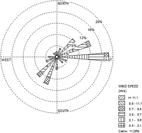
According to the hourly meteorological data measured at Corumbá Airport, the wind blows mainly in the east quadrant, with some variations between the periods of winter and summer. and , referring to 2004, exemplify such behavior. In winter, the wind speed is more intense and the direction predominance is more stable, blowing basically in the east quadrant. In the summer, corresponding to the region's rainy season, the wind speed is lower, whereas the direction is not so permanent and the wind, although blowing mainly from the east direction, may vary from northeast to southeast in their predominance. The wind speed is considered low and reaches an average of approximately 3.0 m/sec.
Figure 3. Wind rose in rainy season.
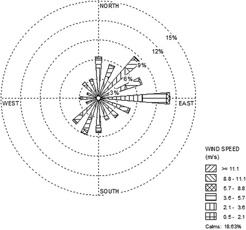
Figure 4. Wind rose in dry season.
CUMULATIVENESS ANALYSIS: APPLICATION TO THE MINERAL SECTOR
Various definitions of the concept of cumulative impact can be found in the literature. SadlerCitation17 defines it succinctly as “the net result of the environmental impacts of various projects and activities,” and U.S. environmental law defines it as “the impact on the environment resulting from a present action when added to other past, present and reasonably predictable future actions.”Citation11
As for synergistic impacts, they are defined as the impact of an undertaking associated with the impact of another undertaking, producing a different effect from the one that would be obtained from the sum of individual impacts. This difference may result from various specific interactions.
For the European Community, the impact assessment techniques used should quantify and forecast their magnitude and significance,Citation18 and the application of a mathematical model is suggested to quantify results in terms of air quality.
One of the prerequisites of cumulative impact analysis is that, wherever possible, impacts should be quantified using some acceptable methods or tools. If cause and effect cannot be quantified, qualitative evaluation procedures may be used. This may happen frequently because many relationships are poorly understood and few site-specific data may be available. Although mining projects can potentially affect many environmental resources, for the purpose of quantification of impacts in the work presented here, only air quality has been considered.
The focus of the work presented here has been more on the methodological aspect than on the validity or acceptability of any particular model. Thus, TSP concentrations can be predicted using the Industrial Source Complex Short-Term version 3 (ISCST3) model of EPA.
ISCST3 provides options to model emissions from a wide range of sources that might be present at a typical industrial source complex, including point, area, and open-pit sources. The ISCST3 dispersion model from EPA was designed to support EPA's regulatory modeling options, as specified in the Guidelines on Air Quality Models, available at http://www.epa.gov/ttn/scram/dispersion_alt.htm#isc3. Some of the ISCST3 modeling capabilities are
| • | ISCST3 model may be used to model primary pollutants and continuous releases of toxic and hazardous waste pollutants. | ||||
| • | ISCST3 model can handle multiple sources, including point, volume, area, and open-pit source types. Line sources may also be modeled as a string of volume sources or as elongated area sources. | ||||
| • | Source emission rates can be treated as constant or may be varied by month, season, hour of day, or other optional periods of variation. These variable emission rate factors may be specified for a single source or for a group of sources. | ||||
| • | The model can account for the effects aerodynamic downwash because of nearby buildings on point source emissions. | ||||
| • | The model contains algorithms for modeling the effects of settling and removal (through dry deposition) of large particulates and for modeling the effects of precipitation scavenging for gases or particulates. | ||||
| • | Receptor locations can be specified as gridded and/or discrete receptors in a Cartesian or polar coordinate system. | ||||
| • | ISCST3 incorporates the COMPLEX1 screening model dispersion algorithms for receptors in complex terrain. | ||||
| • | The ISCST3 model uses real-time meteorological data to account for the atmospheric conditions that affect the distribution of air pollution impacts on the modeling area. | ||||
| • | Results can be output for concentration, total deposition flux, dry deposition flux, and/or wet deposition flux. | ||||
The particulate emissions in a typical opencast mine complex may result mainly from haul and transport roads, exposed overburden dumps or mineral stockpiles, drilling and loading operations in excavated pits, and so on.
Mathematical modeling, by simulating environmental conditions, constitutes an analytical tool that enables impacts that may affect the environment to be quantified. Its advantage in relation to other techniques is that it clearly defines geographical and temporal limits in addition to indicating specific cause-and-effect relations. However, it requires a greater investment of time, resources, and quality of baseline information.
A series of models can be used, from the simplest that consider only one environmental variable, to the most complex, which forecast the behavior of several variables.Citation19 Cumulative impacts may result from individually smaller, but collectively significant, actions that take place over a certain period of time. Thus, to assess the cumulativeness of atmospheric emissions originating from the operations of various mining companies, in accordance with the scenarios proposed, the research used a methodology identified by the Council of Environmental Quality (CEQ), making it possible to quantify the cause-and-effect relations that induce cumulative effect.Citation20,Citation21
There are numerous methods that can be identified by CEQ according to , but there are not any specified appropriate methodologies. A complete review of methods indicates that there is no standard method of cumulative impact assessment among the various planning-oriented tools to analyze and evaluate cumulative impacts. Rather, the types of methods can be used for different purposes depending on the needs of the specific study. Furthermore, the need exists for a typology of pertinent methods.Citation20
Table 2. Primary and special methods for analyzing cumulative effects.20
In the case of the Pantanal SEA of the mining sector, two scenarios were developed that take into account the total expansion goals of the companies.
| • | Scenario 1, which considers the operation of existing mining activities and new investments that have already obtained the mining research permits granted by the National Mineral Production Department and the environmental licenses granted by the state or federal environmental body. | ||||
| • | Scenario 2, which considers the operation of all mining activities included in scenario 1 with the addition of potential new areas for the expansion of existing operations. Thus, the construction of this scenario took into account the plans announced by the companies involving the remainder of the expansion goals. | ||||
Each scenario considered the emissions of PM originating from mining's various operations: opening up mines, ore mining, transportation, ore storage and processing, and the traffic of heavy vehicles along the internal roads of the work areas () according the inventory emissions presented in .
Table 3. Ore extraction scenarios: Production and emission of PM
Table 4. Company 1 (area 1)—emission inventory.Citation13
Table 5. Company 2 (area 2)—emission inventory.Citation13
Table 6. Company 3 (area 3)—emission inventory.Citation13
Table 7. Company 4 (area 4)—emission inventory.Citation13
Table 8. Company 5 (area 5)—emission inventory.Citation13
Scenario 1 indicates that some mining companies may grow by up to 250%, but it is in scenario 2 that projections are the most ambitious, with growth attaining up to 400% as in the case of company 5. Consequently, PM emissions will also be considerably higher, increasing by 150% in relation to scenario 1.
For modeling purposes, it was conservatively considered that the whole area's mining potential would be fully exploited, thus leading to maximum emissions of PM.
The source data required as model input are the locations of various sources of PM in the mines and their dimensions and emission rates. For cumulative impact assessment it is sufficient to have only approximated location and design information for the mines as long as detailed designs are not available at this stage. Location and dimension details were obtained from the digitized maps of mining permits of the National Mineral Production Department Geographic Information System.
Because the ISCST3 model accepts area and open-pit sources as rectangles, these sources were approximated as rectangles without much change in the area or location. Transport roads were approximated into several area segments. In addition, there are several point sources in the mines. However, these are not true point sources as per the definition of different sources given in the model. Rather, they can be assumed to be part of the emissions from the corresponding area or open-pit sources. Furthermore, calculated emission rates from these sources were added to the corresponding area or open-pit sources where they are located. The estimated values of concentration of TSP were transformed into annual averages for comparison with the air quality standard of 80 μg/m3.
DISCUSSION
The results obtained in scenario 1 attained a maximum annual average concentration of 300 μg/m3—approximately 4 times higher than the legal standard. These maximum concentrations estimated by the model are significantly high within the mining area, declining as the distance from the sources of emission increases and attaining very low values of 10 μg/m3 or less near the communities and roads with a higher volume of traffic around the mining area, as shown in
Figure 5. Average concentration TSP in scenario 1 (μg/m3).
The pollutant dispersion simulation study performed for scenario 1, considering the companies' maximum potential extraction of ore, evidences that the impact on air quality caused by all operations together will be quite significant; that is, there will be a considerable increase in the concentration of TSP. However, it also shows that the largest concentrations will occur precisely where the mining companies operate, declining as the distance from the sources of emission increases. In general, given the distance at which the mining areas are located and the reach of the plume observed in the mathematical modeling, the study shows that the projected growth for the sector would not change air quality in Corumbá’s urban or in the flooded area. In scenario 2, as in scenario 1, the study considered the extreme situation in terms of PM emissions so that the worst air quality situation could be assessed.
In this case, the concentration of TSP will attain the significantly higher level of 660 μg/m3, approximately 8 times greater than the legal air quality standard of 80 μg/m3. The maximum concentrations will occur exactly at the sources of emissions and decrease considerably as one move away from the area, falling to levels below the standard near populated areas and roads.
presents the concentration isolines resulting from the simulation in scenario 2. In the latter, the simulation of the dispersion of PM originating from all mining activities, operating together at maximum capacity, showed that their impact on air quality is significant and the concentration of TSP will increase considerably. It also shows that the largest concentrations will occur precisely in the mining area, decreasing as one move away from the sources of emission. Exactly as in scenario 1, the reach of the plume observed in the mathematical modeling shows that the growth of mining would not change the quality of the air in Corumbá’s urban area and in the flooded area.
Figure 6. Average concentration of TSP in scenario 2 (μg/m3).
Only the long-term concentrations were evaluated, once they reflect the prevailing average situation in terms of atmospheric pollutant dispersion in the region.
It is important to emphasize that the concentration peaks concerning maximum daily concentrations reflect situations considered by the simulation model as extremely unfavorable to air pollutant dispersion. It may occasionally in short periods of time occur in the region, in fact not representing the current situation.
The pollutant dispersion models use worst-case scenarios by considering that all area sources would be mined at the same time. This is a valid screening approach under uncertainty for the evaluation of the strategic policy analysis, which would take into account the exploitation that tends to occur in the future. The authors understand that the short-term concentration should be evaluated on the project level; that is, in the EIA.
The impossibility for verifying the accuracy of the obtained results in the applied model is, as well, outstood, once air quality monitoring stations are localized near urban areas, sufficiently far from the study areas, compromising the model resolution.
Note that the evaluated scenarios are based on the premise that all areas being mined have environmental permit or mining concessions operating at the same time at their maximum capacity. In this way, the actual current situation of the mined area is unknown, which impedes the model evaluation for the present conditions and hampers the comparison of the results with the monitored values at the sampling station positioned near one of the mining companies.
ANALYSIS OF RESULTS
The application of the mathematical modeling technique requires information that is not always available, which hinders and compromises the obtained results. One of the greatest difficulties found in current studies is meteorological data availability—a crucial input for this tool. Currently, there is an option of using meteorological files generated by numerical modeling.
The use of meteorological data files produced by simulations with numerical weather forecasting models (NWFM), especially regional ones, may be of great practical use. These files may be sufficient to characterize weather conditions in places of interest, especially when observational data are not available for this purpose. However, the use of NWFMs must be judicious.
The limitations of numerical modeling should always be considered, including the existence of intrinsic errors associated with the approximation of governing equations, continuous in space and time, in discrete points of a grid over the region of interest.
Moreover, the knowledge regarding physical processes that occur in the atmosphere on a very small spatial and temporal scale is still insufficient; thus, the high resolution obtained with the regional NWFMs, which is currently of the order of 1 km, is still not sufficient to properly explicitly represent some meteorological processes and their interaction in the model. This is especially so in the case of those associated with deep convection, microphysics of precipitation, long-wave radiation, short-wave radiation, boundary layers, surface flows, and turbulent diffusion. These phenomena are treated by models in specific procedures called “parametrizations,” which are generally prepared using empirical data. One should also consider the need to carefully characterize the initial conditions, the state of the atmosphere in the region of interest where the project will be undertaken, and the surrounding conditions that indicate the evolution of systems in adjacent areas and may affect the projection in the region of interest supplied to the regional NWFM.
The appropriate use of numerical modeling tools is not easy, and performing a simulation that accurately represents atmospheric behavior may have a high cost.However, in regions where observational data are available, even if only in adjacent areas, they may constitute the most feasible alternative and may even, in some cases, be more representative of climatic conditions in the region of interest. It is true that the volume of information from some meteorological stations is much smaller than that obtained with regional NWFMs; however, it may be sufficient for application, especially in regions where there are no great contrasts between water and land, the topography is not complex and exhibits small variations in height, and the soil cover is homogenous, all adding up to characteristics that favor a regular atmospheric flow.
For the study presented here, it was decided to use local data. However, the monitoring of meteorological parameters in the Pantanal region is incomplete and information is only collected at the Corumbá Airport. There are considerable periods for which absolutely no data are available. The result was that the study could only use 1 yr of data.
Another significant limitation that has been observed in the use of mathematical modeling in SEA studies is the lack of information regarding planned projects. Usually, only a summary containing the area to be occupied, investments, the number of jobs generated, and production capacity is supplied. There is no information about the technologies that will be used.
Another difficulty usually encountered is that air quality is not monitored, thus making it impossible to calibrate the models used. In the case of Corumbá, monitoring is only performed on the outskirts of the urban area, which are approximately 30 km from the mining areas. In the region near Morraria do Urucum, where the mineral exploitation areas are located, particles in suspension are only monitored by one station operated by one of the companies. The results from 1 yr of sampling show that pollution concentration levels did not compromise air quality in the area planned for the installation of the mining and steel pole, which is only influenced by existing extractive activitiesCitation23 and an average concentration of 17 μg/m3 was recorded.
Thus, although various models can be used to quantify cumulative impacts, from the simplest to highly sophisticated ones, the research used the relatively simple EPA Gaussian ISC3 model, given the study's merely indicative nature.
Air quality modeling is a powerful tool to quantify cumulative impacts and “can give unequivocal results.”Citation19–21 However, the acceptance of quantitative modeling results as absolute fact without consideration of the probability range, indicative of possible error, in the reported values may lend unjust weight to the model results when used in decision-making. Decision-makers need to understand the true nature of the information provided and make decisions accordingly.
CONCLUSIONS
The use of mathematical modeling techniques, through the application of the ISC3 model, to quantify the impacts on air quality of iron ore extraction in Brazil's Pantanal region, was undoubtedly successful in providing support for decision-makers.
The assessments evidenced that the pollutant concentration plume will not reach Corumbá’s urban area or affect the air quality of the Pantanal's flooded area.
Considering the group of mining companies that will operate concomitantly in the region, the two scenarios showed significantly high concentrations of TSP in the immediate vicinity of the extraction areas that declined as the distance from the source of emissions increased. It was verified that in areas where some rural communities are located, concentrations will be within air quality standard limits recommended for the protection of human health. However, the mining area and its surroundings possess an extremely rich vegetation and wildlife that will certainly be submitted to concentrations that are much higher than those recommended for their protection.
Despite the high levels of PM emissions that are intrinsic to mining activities, TSP concentrations in the mining activities' area of influence are currently below the primary air quality standard according to the concentrations obtained from the only dust monitoring station in the region close to the mines. However, if TSP concentrations are to be kept within air quality standard limits, it will be necessary to continue and intensify the humidifying of mines' access routes, thus ensuring that current TSP concentration levels will be maintained.
The use of a less sophisticated mathematical model in a study of an indicative nature requires less processing time and reduces the cost of obtaining the information necessary as an input for the tool.
Despite the lack of data for a minimum characterization of the conditions pertaining in the areas surrounding the region modeled, the quantification of impact cumulativeness on air quality was considered to have played an important role in the context of the SEA.
Thus, although SEA studies usually place a greater emphasis on qualitative rather than quantitative aspects, the adoption of a low-complexity pollutant dispersion mathematical model enabled available data to be used and provide support for decision-making.
This approach has been adopted in various SEA studies performed by LIMA, especially of industrial complexes that are being installed along the country's coast (e.g., Ilhéus, Anchieta, Açu, and COMPERJ), thus enriching the content of these assessments and fostering advances in the discussion of strategic options for the detailing and formulation of the programs of undertakings that are being installed and public sector plans and policies. With the SEA, the environmental variable is considered at the very beginning of the planning process, thus enabling the inclusion of recommendations and the identification of policy options that benefit air quality in the regions where these undertakings are being installed.
REFERENCES
- National Environmental Policy: Aims and Mechanisms of Formulation and Application Brazil Law No. 6938; August 31, 1981; Government of Brazil Brasília , , Brazil, 1981
- Partidário , M.R. 2000 . Environmental Impact Assessment Review , 647 – 663 . New York : Elsevier Science .
- Partidário , M.R. 2007 . The Public Participation Manual , Vienna , , Austria : Paper presented at ÖGUT-Australian Society for Environment and Technology/Lebeusministerium .
- Therivel , R. and Partidário , M.R. 1996 . The Practice of Strategic Environmental Assessment , London : Earthscan .
- Therivel , R. 2004 . Strategic Environmental Assessment in Action , London : Earthscan .
- Schmidt , M. , João , E. and Albrecht , E. 2005 . Implementing Strategic Environmental Assessment , Berlin , , Germany : Springer .
- Sadler , B. 1996 . Environmental Assessment in a Changing World: Evaluating Practice to Improve Performance , Ottawa, Ontario , , Canada : Canadian Environmental Assessment Agency and International Association for Impact Assessment .
- Partidário , M.R. and Clark , R. 2000 . Perspectives on Strategic Environmental Assessment , Boca Raton, FL : CRC .
- Partidário , M.R. and Fischer , T.B. 2004 . Assessing Impact: Handbook of EIA and SEA Follow-Up , Edited by: Morisson-Saunders , A. and Arts , J. London : Earthscan .
- Partidário , M.R. and Arts , J. 2005 . Exploring the Concept of Strategic Environmental Assessment Follow-Up . Impact Assess. Project Appraisal , 23 : 246 – 257 .
- Applying Strategic Environmental Assessment Organization for Economic Co-Operation and Development Paris , , France 2006
- Basic Criteria and General Guidelines for Environmental Impact Assessments CONAMA Resolution No. 001; Ministry of the Environment. National Environment Council : Brasília , , Brazil 1986
- Corumba Industrial-Mining Pole Strategic Environmental Assessment and its Influencies over Pantanal Wetland; Dialogue Platform; Environmental Sciences Laboratory, Alberto Luiz Coimbra Institute Post-Graduate Studies and Research in Engineering, Federal University of Rio de Janeiro Rio de Janeiro , , Brazil 2008
- Air Quality Standards Foreseen in PRONAR CONAMA Resolution No. 03; Ministry of the Environment; National Environment Council Brasília , , Brazil 1990
- Analytical Wetland Diagnosis and High Paraguay Basin Executive Abstract as part of Subproject 9.4th - Elaboration of the Analytical Diagnosis of Wetland and Paraguay Basin - DAB - National Water Agency, Government of Brazil Brasilia , , Brazil 2003
- Environmental Zoning of the West Border of Wetland - Urucum Massif and Boundaries, EMBRAPA Brasilia , , Brazil 2007
- Sadler , B. and Verheem , R. 1996 . Strategic Environmental Assessment: Status, Challenges and Future Directions , Amsterdam , , The Netherlands : Ministry of Housing, Spatial Planning, and the Environment .
- Weaver , A. and Caldwell , P. 1999 . Handbook of Environmental Impact Assessment , Edited by: Petts , J. Vol. 2 , 377 – 403 . Oxford , , United Kingdom : Blackwell Science .
- Walker , L.J. and Johnston , J. 1999 . Guidelines on the Assessment of Indirect and Cumulative Impacts as well as Impact Interactions , Luxembourg : Office for Official Publications of the European Communities .
- Regulations for Implementing the Procedural Provisions of the National Environmental Policy Act. CFR, Parts 1500–1508, Title 40 http://www.nepa.gov/nepa/regs/ceq/toc_ceq.htm (http://www.nepa.gov/nepa/regs/ceq/toc_ceq.htm) (Accessed: 8 October 2010 ).
- Smit , B. and Spaling , H. 1995 . Methods for Cumulative Effects Assessment . Environ. Impact Assess. Rev. , 15 : 81 – 106 .
- 2008 . Compilation of Air Pollutants Emission Factors (AP-42) , Washington , DC : U.S. Environmental Protection Agency .
- 2007 . Air Quality and Meteorology Monitoring Report in MMX Iron Steel Company Influency Area , Rio de Janeiro , , Brazil : MMX .