abstract
Wintertime cold outbreaks were studied via a 2-D numerical model set across an 80 km wide non-frozen sea gulf along 60°N (‘Gulf of Finland’). In calm conditions, land breezes develop over both coasts with relatively large along-shore wind components. The mid-gulf convergence of the colliding land breezes leads to a moderate rising motion at about 600 m height, forcing bands of low cloud and snowfall along the gulf, whereas the near-surface horizontal wind shear may induce ‘mini-hurricanes’. A weak large-scale cold outbreak across the gulf distorts the land breeze cells, damping the rising motion, whereas a moderate cross-coast outbreak modifies them into a typical heat island circulation pattern with only a modest rising motion over a flat windward shore. A cold outbreak along the non-frozen gulf leads to strong heat transfer from the sea. This maintains the embedded coastal land breeze circulations that contribute to a double low-level jet structure. The strongest rising motion was obtained for surface winds blowing along the gulf. It is suggested that the Swedish Gävle snowstorm of December 1998 was such a case.
1. Introduction
Cold air outbreaks are quite common over the Baltic Sea area in the autumn and in winter. During a cold outbreak, the thermal stratification is typically rather stable over the land but very unstable over a non-frozen sea surface. The turbulent heat fluxes can thus be high, and a strong convection prevails over the sea. The convection often results in cloud formation and heavy snow showers. These tend to be organized into rolls and bands depending on the large-scale flow and on the fetch over the warmer water. In the relatively narrow Gulf of Finland, cold outbreaks are associated with large coastal gradients in the wind speed and air temperature, and bands of intense snowfall are common. Their prediction and understanding is important as these showers may cause serious problems, for example for the coastal road, train and aircraft traffic.
Cold air outbreaks and their air mass transformations over the warmer water have been studied extensively for the mid-latitude US Great Lakes, particularly in connection with the associated ‘lake-effect’ snowstorms (e.g. Hjelmfelt, Citation1990; Laird et al., Citation2003; for a review see Pielke, Citation2002), and also downwind of the Arctic sea ice edge (e.g. Brümmer, Citation1997), using aircraft and ship observations and modelling. In these cases, the fetches of cold air travelling over the warm water have been quite long. Cold outbreaks over the Baltic Sea area have been discussed by Andersson and Gustafsson (Citation1994), Gustafsson et al. (Citation1998) and Vihma and Brümmer (Citation2002), but in these cases, the Gulf of Finland and the Gulf of Bothnia have been ice covered ( shows the geography). The narrowness of those gulfs and the high latitude with the associated strong Coriolis force may cause differences from the Great Lakes experiences. Furthermore, the topography around the Gulf of Finland is relatively flat, unlike that of the Great Lakes region.
The flow above a warm surface zone has also been studied using linear theory. This leads, for example to various analytic sea/land breeze models in a calm basic state (for reviews, see Atkinson, Citation1981; Pielke, Citation2002) and to linear heat island circulation models in a basic flow (e.g. Olfe and Lee, Citation1971; Hsu, Citation1987; Baik, Citation1992; Lin, Citation2007). However, a more general treatise of cold outbreaks over a high-latitude non-frozen sea gulf has been lacking. It is the subject of this article. Here, a high-resolution 2-D numerical model with adequate physical parameterizations is set across an 80 km wide east–west sea gulf at 60°N (mimicking the Gulf of Finland), and several wintertime cold air masses and cold outbreaks are simulated in this environment. Calm cases lead to steady land breezes over both coasts, whereas a basic flow may considerably modify or destroy them. The simulations also display narrow bands of strong rising motion, coastal low-level jet (LLJ) structures and other small-scale features that may not be resolved by a larger scale model. The idealised simulations may help to understand why such features should exist as the result of the dynamics and physics of the flow situations. Some observed cases are briefly discussed to highlight these mechanisms.
This study is related to Savijärvi (Citation2011a), where a similar setup was used for the summertime (although in overcast conditions to exclude sea breezes). When the sea gulf was colder than the air, as during spring and early summer, anti-heat island circulation features were evident, while later in the summer with the sea slightly warmer than the air, heat island circulations did not quite show up. The sea breeze aspects were addressed by Savijärvi et al. (Citation2005) and Gahmberg et al. (Citation2010), and the small-scale local wind features near the coastlines by Savijärvi (Citation2004). The present article now completes this series of studies for the mesoscale and local winds around the coasts of a high-latitude sea gulf by considering cases where the sea is a lot (20–30 K) warmer than the air. The results are also applicable more generally. In particular, the snowstorm of December 1998 in Gävle, Sweden, is suggested as an extreme case in Section 6. It bears some resemblance to the Great Lakes snowstorms.
2. The model and the environment for the simulations
The 2-D model of the University of Helsinki uses the standard sigma coordinate dynamical core of Alpert et al. (Citation1982) and Alpert and Savijärvi (Citation2008). The non-changing large-scale pressure gradient is given in these idealised simulations by a constant barotropic geostrophic wind
V
g, and the advections are Lagrangian via upstream cubic spline interpolations. The parameterisations include a force-restore snow scheme, a four-band shortwave radiation scheme (Savijärvi et al., Citation1997), and a six-band long wave (LW) scheme of ECMWF model origin (modified to allow high vertical resolution, Savijärvi and Räisänen, Citation1998). The surface-air exchanges are via Monin–Obukhov relations and turbulence is represented by a Blackadar-type first-order closure. The stability functions apply the Dyer–Businger forms for unstable layers (Ri<0), while for stable layers ; the latter local formulation is based on the asymptotic theory (Zilitinkevich et al., Citation2002; Savijärvi, Citation2009). The same forms of f(Ri) are applied for the surface fluxes. Hence, the surface layer is an integral part of the model's boundary layer (BL). Moisture is predicted, the radiation schemes thereby obtaining appropriate instantaneous absorber amounts. The present integrations are initialised using dryish conditions (50% relative humidity (RH)), and the cloud physics is switched off (clear sky simulations). The model has been applied previously in many studies of sea/land breeze and sea ice edge winds with realistic results (e.g. Savijärvi and Matthews, Citation2004; Vihma et al., Citation2005; Savijärvi et al., Citation2005; Gahmberg et al., Citation2010; Savijärvi, Citation2011a,b); these references and the references therein provide further details of the model.
The environment for the present wintertime simulations is the same as in the summertime simulations of Savijärvi (Citation2011a): the 2-D model is set across an idealised 80 km wide east–west sea (‘Gulf of Finland’) at 60°N in a horizontal grid of 132 points 2 km apart. Flat coasts with 25 sigma levels are used with the model top well above 5 km, whereas the lowest levels are at about 2 m and 10 m above the surface. Sigma vertical velocities vanish at the surface and at the top, and free flow horizontal boundary conditions are applied. Land is snow covered. The snow surface temperatures are predicted, whereas the sea surface temperature (SST) is fixed. The model is started at 0000 local solar time using an initial air surface and snow temperature T s and a constant lapse rate. Sensitivity studies are made by varying the values of T s, the roughness of the sea, and, in particular, V g.
Although the gulf is here considered to be west-to-east, the simulations are independent of this assumption, and the orientation of the gulf (or a long lake) is arbitrary. In Section 6, an example of Gulf of Bothnia is given.
3. Gulf effects in cold and calm conditions
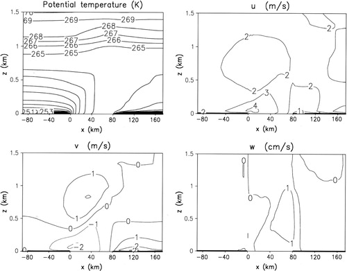
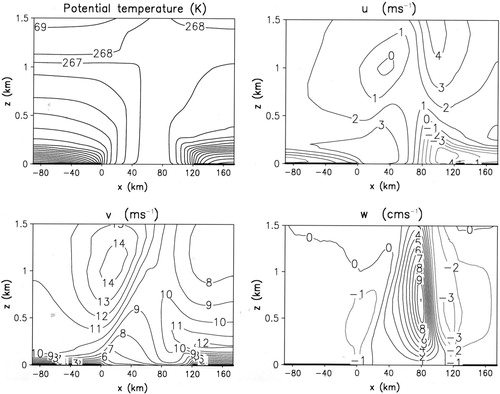
During late autumn and early winter, the Gulf of Finland is not yet frozen but the air can be quite cold after cold outbreaks. The surface temperature difference may be tens of degrees between the land and the open sea. The induced circulations (land breezes) might, hence, become intense over the gulf, but this may depend strongly on the surface heat fluxes (or quality of parameterisations thereof!), and on the prevailing large-scale winds. Here a calm ( V g=0), cold and clear sky 60°N ‘control’ case is firstly simulated, as might occur, for example after a cold front passage. Late December conditions are assumed; thus, the weak solar radiation has no significant effect, although it is included in the simulations. The roughness length z 0m of the sea is 0.1 mm (as for low wind on coastal waters, Stull, Citation1988), while z 0m over land is 0.5 m (forest), and z 0h=z 0m. The SST is set to + 1 °C, the land areas are assumed to be snow covered and the air is initially calm, T s being −15 °C with a lapse of 2 K km−1 and RH 50%. The snow surface then starts to cool by strong upward net LW radiation, until the increasing downward turbulent heat transfer by the evolving local winds and the upward heat flux from the deeper snow layers balance the situation. This leads to a strong surface inversion over land, which is typical in such clear, calm and cold conditions.
The + 20 h potential temperature field of indicates a deep convective boundary layer (CBL) above the non-frozen sea with surface inversions over the cold coasts. The 2 m temperatures are around −7 °C over the sea and −14 °C at the coasts, dropping to −27 °C far inland, where the winds are weak and, therefore, a strong surface inversion prevails. These values are in reasonable agreement with wintertime observations after strong cold front passages in southern Finland.
Fig. 1. Cross sections across an 80 km wide sea gulf at 60°N. Calm ( V g=0), cold, clear sky December day,+20 h simulation. Δx=2 km, SST = + 1 °C, z 0=0.1 mm at the sea.

The relatively warm non-frozen sea with its convective upward heat flux triggers (within an hour in the model) land breezes that initially blow straight across the coasts. In about 12 h, the strong Coriolis force of 60°N has brought about a considerable turning of these breezes to the right, the winds and temperatures having reached a quasi-steady state with little further change. depicts the steady state after a 20 h simulation. A land breeze cell is located over both coasts with ∣u∣ of 2.5 ms−1 near the surface and a return flow of 1 ms−1 at about 1 km height. The related values of ∣v∣ are 3 ms−1 near the surface and 2 ms−1 at 700–1100 m. The land breezes at the standard 10 m height (the steady-state winds of the control simulation) are about 3.5 ms−1 at both coasts, blowing about 55° to the right from the direct seaward direction.
The strong low-level horizontal convergence by the opposite land breezes leads to a rising motion through mass continuity: w is + 7 cm s−1 at 500–600 m height in the middle of the gulf in . Along-shore bands of convective clouds and snow showers, presumably triggered by the rising motion of the moist near-surface marine air, are typical in the middle of the Gulf of Finland in such cold and calm conditions during late autumn and early winter (CitationSaltikoff, 2011). Furthermore, the near-surface winds also display considerable horizontal shear
in the middle of the sea, as seen in . The convergent, convective and sheared near-surface flow may induce small-scale (diameter ∼3–5 km) vortices about the vertical axis; such ‘mini-hurricanes’ are occasionally seen in the Doppler radar wind images within the snow bands (Laird et al., Citation2003; CitationSaltikoff, 2011). Their proper simulation would call for a very fine scale three-dimensional model.
If z 0 is increased from the more realistic 0.1 mm to the large value of 1 mm over the gulf (corresponding to windy high wave conditions over oceans, Stull, Citation1988), the model's steady-state 2 m temperatures increase about 1.5 K over the sea, due to the increased turbulent heat transfer. The horizontal winds increase about 20%, despite the much rougher sea surface, and the maximum vertical velocity also increases from 7 to 9 cm s−1. Thus, the land breeze circulation is moderately sensitive to the marine z 0, the driving heat flux change being compensated to some extent by the opposite change in the wave-induced drag caused by the associated surface winds.
demonstrates the effect of the coldness of the air mass on the model's calm case land breeze circulations. Here, the initial surface air temperature T s is varied, everything else being the same as in the control simulation. The circulation patterns remain similar to those in , their intensities increasing with the driving temperature difference. One may note that the moderate difference of 19 K between the SST and the inland T2m (top row in ) manages to trigger only a weak coastal land breeze of 2.3 ms−1 and a mid-gulf rising motion of 1 cm s−1. On the other hand, the really large but not unrealistic difference of 33 K can maintain quasi-steady coastal land breezes of 5 ms−1 with a rising motion of 12 cm s−1 (bottom row).
Table 1. The maximum u, v and w at the indicated heights, T2m at the coast and far inland as the function of the initial surface temperature T s, from a calm case + 20 h simulation with SST of 1 °C.
4. Gulf effects during cross-coastal cold outbreaks
depicts a similar steady-state situation as but with a weak constant geostrophic wind V g blowing across the coasts from left to right; (u g, v g )=(2, 0) ms−1. The advection by this basic flow is seen in the potential temperature field: the downstream growth of the CBL over the warm sea is quite visible on the offshore (left) coast, whereas over the onshore (right) coast, the air warmed by the sea climbs over the strong surface inversion, forming an internal BL. The two land breeze cells are recognisable in , being superposed on the weak basic flow, but they are clearly advected downstream. The windward coast cell is weak, as it has less contact area into the driving warm sea surface. The weak convergence zone and the maximum vertical velocity of only 1.5 cm s−1 are now located near the windward coast. Thus, even a weak cross-coastal basic flow (or a component thereof) can considerably distort and damp the land breeze circulations of a cold air mass above a non-frozen sea gulf.
Fig. 2. As Fig. 1 but for (u g, v g)=(2, 0) ms−1 ( V g from left to right).
The pattern of w in resembles that caused by a steady basic flow past a warm zone. If ug is increased above 2 ms−1, the surface wind starts to increase strongly just above the warm sea; more sensible (and latent) heat is transferred to the air; and a rising warm plume appears in the rear of the sea zone over the windward coast. In effect, the offshore coast land breeze cell gets advected over the warm sea zone and stays phase locked there, whereas the onshore coast cell is pushed over the cold land, where its contact to the warm sea is completely lost and it hence disappears.
Such features of a steady flow over a warm zone have been extensively studied by linear and numerical models (see Introduction) and have been observed in many mid-latitude and tropical heat island campaigns (e.g. Savijärvi and Matthews, Citation2004). and demonstrate that the same features can be recognised during a cold outbreak across a high-latitude sea gulf. displays the control case but for (u g, v g) of (6, 0) ms−1. The θ and wind fields in indicate a quite stable and shallow Ekman layer over the cold upstream (left) coast, but over the warm gulf the surface winds increase to about 6 ms−1 (i.e. to V g). Once over the cold windward coast, the winds quickly return to the quasi-Ekman profile of a very stable and shallow BL, indicating weak surface winds and large cross-isobar angles and displaying no signs of the onshore coast land breeze cell, which is still recognizable from .
Fig. 3. As Fig. 1 but for (u g, v g)=(6, 0) ms−1.
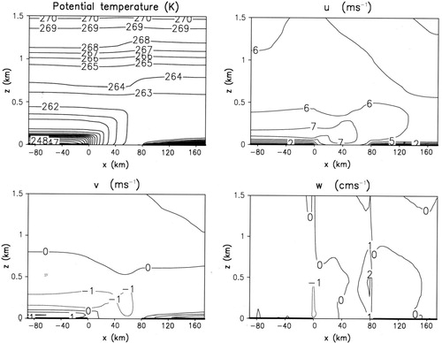
The w pattern of is similar to that in but with a modest w-maximum of 2 cm s−1 above the onshore coast. However, the surface drag contrasts and the coastal convergence may play a role here because the wind across the coast is now moderate (Alestalo and Savijärvi, Citation1985). If z 0m is set to 1 mm both over land and over sea (i.e. no drag contrasts and hence no coastal convergence due to them), the w-maximum drops to 1 cm s−1. Thus, even with the large drag contrast between rough forest and smooth sea (which appears to contribute about half of the rising motion on the windward coast), cold outbreaks straight across the gulf cannot induce strong vertical velocities in the present simulations. The 80 km wide gulf is too narrow for onshore–offshore winds to induce strong heat transfer (and hence strong vertical motions) during the short period the air spends crossing it. Moreover, the land is assumed to be flat, and the values of z 0 remain modest over the sea as the fetch for wave production is limited. In contrast, the heavy snowfalls on the windward coasts of the Great Lakes are enhanced partly by the wide distances the cold air stays over the large warm lakes, and partly by the strongly sloping coasts that induce strong forced lifting of the warm, moist and convective air (Pielke, Citation2002).
Finally, Figs. nicely demonstrate the transition from a pure land breeze circulation () to the steady heat island circulation induced by a weak () and a moderate () constant basic flow across a warm zone. This transition and the general solutions were studied by Dalu et al. (Citation1996) using the linear theory. Their solutions, although mathematically exact (within the assumptions made), are unfortunately rather complex and unillustrative. Moreover, non-linearities in advection and in the now strong turbulent heat diffusion cannot be included in the linear theory, neither can the contrasts of surface roughness. Hence, Figs. provide a perhaps more realistic and easily understandable demonstration of this transition for the 80 km wide warm zone at 60°N.
5. Gulf effects during along-shore cold outbreaks
If the cold outbreak blows instead along the sea gulf or along a long lake, the cold near-surface air spends a lot of time above the warm gulf. Furthermore, fetches being long, the wind-raised waves can grow into a well-developed sea state with high roughness lengths z 0. The convective flow may, therefore, gain relatively much more heat from the sea surface compared to the across-gulf flows and may hence exhibit more extreme behaviour.
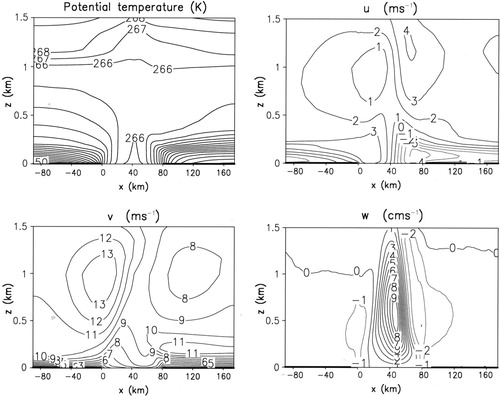
In , the model's steady state is shown as in Figs , but for V g of 10 ms−1 along the gulf; i.e. (u g, v g)=(0, 10) ms−1. (Cold air outbreaks along the Gulf of Finland tend to be easterly rather than westerly, bringing in arctic air from Siberia. For easterly V g, Finland is on the right in and , Estonia on the left.) displays a windy and highly convective well-mixed CBL over the warm sea, while over the cold and stable inland areas, quasi-Ekman wind profiles are seen, the surface drag and the wind-driven turbulence maintaining a cross-isobar cross-coastal wind component u of −2… − 3 ms−1 at about 100 m height. Superposed on this basic flow are also two land breeze cells, much as in but advected slightly to the left. Their return flows are quite evident in the v-field at 1 km height, superposed on the constant v g of 10 ms−1. The land breeze perturbation is relatively strong on the lower pressure (left) coast, where the cross-isobar flow advects warmer maritime air into it. This enhances the driving temperature and pressure gradient contrasts at that coast. The convergence of the two land breezes is hence quite strong in the lowest 300 m over the sea. This leads to a rising motion of + 8 cm s−1 at 600 m height slightly left of mid-gulf (). Bands of cloud and snow along the gulf could, thus, be expected during along-shore cold air outbreaks due to the pattern of strong rising motion related to the land breezes. Anderson and Gustafsson (1994) studied a cold air outbreak along the Swedish shore of the Baltic Sea; they stressed the importance of the associated single land breeze cell for the development of a strong observed snow band along the coast.
Fig. 4. As Fig. 1 but for (u g, v g)=(0, 10) ms−1 ( V g into the figure plane), z 0=1 mm at the sea.
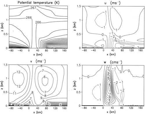
Fig. 5. As Fig. 4 but for (u g, v g)=(2, 9.8) ms−1.
Cross-coast advection by the weak frictional flow component is, thus, evident in for moderate V g along the gulf. This enhances the land breeze on the windward coast, analogously to weak large-scale winds from warm land being able to enhance sea breezes (e.g. Gahmberg et al., Citation2010). But what would happen if the cross-coastal frictional BL wind is compensated by an opposite basic flow component, so that the resulting surface and near-surface winds would be shore parallel, instead of V g? Would the strong damping effect presented by a weak cross-coastal wind component (; Section 4) thereby disappear? This is answered in , where V g is (+2, 9.8) ms−1. Here, the cold outbreak is still 10 ms−1 in speed but it blows in an angle of 12° across the coastline. In , the warmest air does stay in the middle of the sea, and the strong land breeze cells are also symmetrically located. They support a double LLJ structure: the strong return flow of the left coast cell induces a LLJ (v of 13 ms−1) above that coast at 1 km height, while the land breeze of the right coast maintains a v-maximum of 11 ms−1 at about 250 m height.
The concentrated low-level convergence of the strong land breezes and the upper divergence of their return flows lead to a strong rising motion; w is + 9 cm s−1 at 500–600 m height 30 km off the higher pressure (right) coast as shown in . This is the strongest rising motion obtained by varying the direction of the 10 ms−1 V g in small steps through 360° in the present experiments (as in Gahmberg et al., Citation2010). It could easily induce snowfall in the converging, rising near-surface air that has collected lots of warmth and moisture during its long trip along the windy, warm sea surface.
Cold air outbreaks from the east-eastsoutheast (E-ESE) sector along the non-frozen Gulf of Finland are indeed often associated with bands of snow showers. One such case occurred on 17 January 2006, when the 12UTC sounding of upstream St. Petersburg indicated –16 °C near the surface with the 850 hPa wind (∼V g) being 10 ms−1, 110°. The University of Helsinki Doppler weather radar revealed easterly winds and snow bands off the Finnish coast 17–18 January 2006. A strong and steady shore-parallel zone of low-level convergence was seen in the Doppler display, prevailing 10–20 km off the coast over the sea, much like as shown in .
6. The Gävle 1998 snowstorm
Shoreline-following cloud bands, associated with along-shore basic flows discussed in Section 5 and producing heavy snowfalls near shores, have frequently been observed and modelled also for the US Great Lakes. If such a strong snow band crosses a peninsula or hits into a curving shoreline in the downwind end of a lake, heavy snowfalls may occur (Hjelmfelt, Citation1990; Pielke, Citation2002).
Such was probably the case in the Gävle snowstorm, where during 6–8 December 1998, an arctic north-easterly outbreak blew for three days along the non-frozen Gulf of Bothnia, bringing lots of snow to the Swedish coastal city of Gävle (60.7°N, 17.2°E) about 150 km north of Stockholm. shows the sea level pressure, the 500 hPa heights and SYNOP observations for 7 December 1998 12UTC. Note the strong geostrophic flow from the northeast and surface winds along the Gulf of Bothnia, whereas along the Gulf of Finland, the easterly geostrophic wind is weak and the coastal surface wind observations indicate land breezes.
Fig. 6. Sea level pressure (dashed lines, hPa), 500 hPa heights (solid lines, gpm) and SYNOP observations from 7 December 1998 12UTC over the Gulf of Bothnia (between Sweden and Finland) and the Gulf of Finland (along 60°N). The location of Gävle, Sweden is marked.
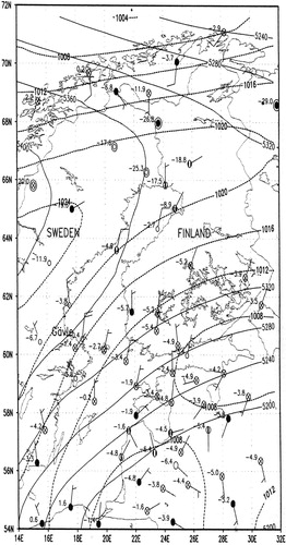
As the Swedish coast of the Gulf of Bothnia runs approximately to the north-northeast (NNE), the situation there resembles that of except that the Gulf of Bothnia is on the average wider than 80 km. , therefore, presents the idealized V g=(2, 9.8) ms−1 simulation otherwise as in , but for a gulf made 120 km wide. ‘Sweden’ (e.g. across Hudiksvall observatory 120 km north of Gävle, T2m of –3.8 °C in ) is on the right in , ‘Finland’ on the left and the basic flow is 10 ms−1 from the NE, roughly along the gulf. The observed Hudiksvall 850 hPa wind was about 20 ms−1 NE during the episode (Bengtsson, Citation2000), but V g of 10 ms−1 is used here in order to allow direct comparison with .
Fig. 7. As but for a gulf 120 km wide.
displays a scene much like , but the wider gulf facilitates even stronger land breezes over the sea. Consequently, there is a shore-parallel LLJ (v∼14 ms−1) near the left coast, whereas strong near-surface shore-parallel winds (v∼12 ms−1), strong convergence and a strong rising motion (w∼10 cm s−1 at 600 m height 40 km off the shoreline) characterise the ‘Swedish’ coast. The Doppler weather radar at Hudiksvall observed a quasi-stationary shore-parallel band of heavy snowfall about 50 km out to the sea with strong surface winds from NNE during the Gävle snowstorm (Bengtsson, Citation2000). This band of heavy snowfall hit into the eastward-curving shoreline () right over Gävle, resembling the US Great Lakes cases quoted above. In Gävle, more than 1 m of snow fell during 6–8 December, paralysing the city. A snow band was seen also along the Finnish coast in the composite radar pictures of Bengtsson (Citation2000).
Although the simulation in is highly idealised, it probably correctly emphasises the essential role of the strong sea-air exchange and the resulting double land breeze structure in the maintenance of the strong, steady and narrow convergence pattern driving the extreme rising motion, and hence the shore-parallel band of intense snowfall, which together with the coastal geography, presumably led to the Gävle snowstorm.
7. Conclusion
Wintertime cold air outbreaks over a high-latitude non-frozen sea gulf were studied by using a 2-D 2 km grid length atmospheric model set across an idealised ‘Gulf of Finland’. Calm, clear sky cold conditions, as after a cold front passage, led into steady land breeze circulations over both coasts, however with relatively large along-shore wind components because of the high latitude (60°N): on both coasts, the 10 m wind was 3.5 ms−1, 55° to the right from direct seaward. Thus, both horizontal shear and convergence occurred near the surface in the middle of the gulf. The convergence of the colliding land breezes led to a moderate rising motion (w∼7 cm s−1) at about 600 m height. This can force bands of low cloud and snowfall along the gulf, while the shear might force small-scale vortices (∼3–5 km, called ‘mini-hurricanes’ by duty forecasters) that are occasionally seen in the Doppler radar winds within the snow bands during calm, cold large-scale conditions.
The land breeze circulations were moderately sensitive to the sea roughness lengths and to the coldness of the air mass. A weak geostrophic wind across the gulf advected and distorted the steady land breeze cells, effectively damping the rising motions. A moderate cross-coastal cold outbreak modified the land breezes into the classical heat island circulation pattern. However, only a modest rising motion (∼2 cm s−1) then occurred along the windward shores of the flat coast ‘Gulf of Finland’ (unlike on the US Great Lakes), due to insignificant topographical forcing and small fetches for air crossing the narrow gulf.
A moderate cold outbreak along the warm gulf led on the other hand to strong heat transfer from the sea (due to the winds, the highly convective conditions, the long fetches, high waves and hence large z 0h), maintaining the coastal land breeze circulations embedded in it. The Coriolis turning of their return flows led to a double LLJ structure in the coastal winds. The strongest rising motion (∼9 cm s−1) was obtained over the sea near the higher pressure coast, when the surface winds were blowing along the gulf, V g, thus, being inclined 10–20° with regard to the shoreline.
Shore-parallel bands of intense snow showers do often occur on the Finnish coast during easterly cold outbreaks along the non-frozen Gulf of Finland, especially when the large-scale flow is from the E-ESE sector. This would seem to agree with the above idealised simulations. It is suggested that the Swedish Gävle snowstorm of December 1998 was an analogous case. It occurred during an episode of cold north-easterly large-scale flow with surface winds along the Gulf of Bothnia. The associated quasi-steady shore-parallel band of heavy snowfall off the Swedish coast (observed by the radar at Hudiksvall) hit into the curving coastline at Gävle for three days and the city was buried in a metre of snow.
8. Acknowledgements
This work is related to the Academy of Finland grants 54084, 167836, 210794, 126853 and 128799. Calculations were made in the Centre of Scientific Computing, Espoo, Finland. The comments of the reviewers helped to clarify the text.
References
- Alestalo M. Savijärvi H. Mesoscale circulations in a hydrostatic model: coastal convergence and orographic lifting. Tellus. 1985; 37A: 156–162.
- Alpert P. Cohen A. Neumann J. Doron E. A model simulation of the summer circulation from the eastern Mediterranean past Lake Kinneret in the Jordan Valley. Mon. Wea. Rev. 1982; 110: 994–1006.
- Alpert P. Savijärvi H. On the numerical asymmetry in calculating Coriolis terms through the splitting method in a mesoscale model. Int. J. Environ. Pollution. 2008; 32: 139–148.
- Andersson T. Gustafsson N. Coast of departure and coast of arrival: two important concepts for the formation and structure of convective snowbands over seas and lakes. Mon. Wea. Rev. 1994; 122: 1036–1049.
- Atkinson, B. W. 1981. Mesoscale atmospheric circulations. Academic Press: London.
- Baik J.-J. Response of a stably stratified atmosphere to low-level heating–an application to the heat island problem. J. Appl. Meteorol. 1992; 31: 291–303.
- Bengtsson, L. 2000. Numerical studies of the energy and water cycle of the Baltic region. Final report, EU NEWBALTIC II (ENV4-CT97-0626), available from MPI-Hamburg, 203 pp.
- Brümmer B. Boundary layer mass, water and heat budgets in wintertime cold-air outbreaks from the arctic sea ice. Mon. Wea. Rev. 1997; 125: 1824–1837.
- Dalu G. A. Pielke R. A. Baldi M. Zeng X. Heat and momentum fluxes induced by thermal in homogeneities with and without large-scale flow. J. Atmos. Sci. 1996; 53: 3286–3302.
- Gahmberg M. Savijärvi H. Leskinen M. The influence of synoptic scale flow on sea breeze induced surface winds and calm zones. Tellus. 2010; 62A: 209–217.
- Gustafsson N. Nyberg L. Omstedt A. Coupling of a high-resolution atmospheric model and an ocean model for the Baltic Sea. Mon. Wea. Rev. 1998; 126: 2822–2846.
- Hjelmfelt M. R. Numerical study of the influence of environmental conditions on lake-effect snowstorm on Lake Michigan. Mon. Wea. Rev. 1990; 118: 138–150.
- Hsu H. -M. Study of linear steady atmospheric flow above a finite surface heating. J. Atmos. Sci. 1987; 44: 186–199.
- Laird N. F. Walsh J. E. Kristovich D. R. Model simulations examining the relationship of lake-effect morphology to lake shape, wind direction, and wind speed. Mon. Wea. Rev. 2003; 131: 2102–2111.
- Lin, Y. -L. 2007. Mesoscale dynamics. Cambridge University Press: New York.
- Olfe D. B. Lee R. L. Linearized calculations of urban heat island convection effects. J. Atmos. Sci. 1971; 28: 1374–1388.
- Pielke, R. A. 2002. Mesoscale meteorological modelling. 2nd ed. Academic Press: San Diego.
- Saltikoff, E. 2011. On the Use of Weather Radar for Mesoscale Applications in Northern Conditions. Finnish Meteorological Institute Contributions, FMI, Helsinki. 88, 38 pp.
- Savijärvi H. Arola A. Räisänen P. Shortwave optical properties of precipitating water clouds. Quart. J. Roy. Meteor. Soc. 1997; 123: 883–899.
- Savijärvi H. Model predictions of coastal winds in a small scale. Tellus. 2004; 56A: 287–295.
- Savijärvi H. Stable boundary layer: model parameterizations for local and larger scales. Quart. J. Roy. Meteor. Soc. 2009; 135: 914–921.
- Savijärvi H. Anti-heat island effects and low level jets on a sea gulf. Tellus. 2011a; 63A: 1007–1013.
- Savijärvi, H. 2011b. Antarctic local wind dynamics and polynya effects on the Adelie Land coast. Quart. J. Roy. Meteor. Soc. 137, 1804–1811. 10.3402/tellusa.v64i0.12244.
- Savijärvi H. Matthews S. Flow over small heat islands: a numerical sensitivity study. J. Atmos. Sci. 2004; 61: 859–868.
- Savijärvi H. Niemelä S. Tisler P. Coastal winds and low level jets: simulations for sea gulfs. Quart. J. Roy. Meteor. Soc. 2005; 131: 625–637.
- Savijärvi H. Räisänen P. Longwave optical properties of waterclouds and rain. Tellus. 1998; 50A: 1–11.
- Stull, R. B. 1988. An introduction to boundary layer meteorology. Kluwer: Dordrecht.
- Vihma T. Brümmer B. Observations and modelling of on-ice and off-ice flows in the northern Baltic Sea. Boundary-Layer Meteorol. 2002; 103: 1–27.
- Vihma T. Lüpkes C. Hartmann J. Savijärvi H. Observations and modelling of cold-air advection over Arctic sea ice in winter. Boundary-Layer Meteorol. 2005; 117: 275–300.
- Zilitinkevich S. Perov V. L. King J. Near-surface turbulent fluxes in stable stratification: calculation techniques for use in general-circulation models. Quart. J. Roy. Meteor. Soc. 2002; 128: 1571–1587.