

ABSTRACT
Recently, the use of stereoscopic three-dimensional (3-D) projection displays has increased in geoscience education. One concern in employing 3-D projection systems in large lecture halls, however, is that the 3-D effect is reported to diminish with increased angle and distance from the stereoscopic display. The goal of this work was to study that effect in a classroom “real-world” lecture environment where such technology would actually be employed. Introductory physical geography concepts were taught to undergraduate students at the University of Kansas through a GeoWall (passive 3-D projection system) display with either static diagrams or interactive globe imagery (Google Earth). Student learning was gauged using both formative (in-class clicker questions) and summative (exam) assessments. We evaluated the spatial structure of students' formative and summative scores for two concepts: Earth–Sun geometries, taught with static images only, and arid landscapes and aeolian processes, taught with Google Earth only. Three significant results were observed: (1) students' ability to accurately observe the 3-D effect was not restricted to the recommended seating angles when using static images, (2) no spatial patterns of improved learning were observed when using static images only; and (3) a significant difference in learning was observed based on seating angles when using Google Earth. Although this study did not compare learning outcomes against a control group, as would be done in a tightly controlled experimental setting, our findings imply that seating angle should be considered in the design of a new classroom equipped with a stereoscopic display or when choosing an existing classroom to retrofit with this technology, particularly, if interactive, globe imagery, such as Google Earth, is used as a primary teaching tool.
Acknowledgments
Partial support for this work was provided by the National Science Foundation's Geoscience Education program under Award GEO-1035035. Any opinions, findings, and conclusions or recommendations expressed in this material are those of the authors and do not necessarily reflect the views of the National Science Foundation.
FIGURE 1: Dimensions and arrangement of seats in the classroom used in this study. Letters on either end of the rows refer to blocks of seats (i.e., approximately one-half the seats in most rows) used to randomize student seating assignments. The medium-gray shaded area between the 30° lines refers to recommended seating angles; light-gray shaded areas between 30° and 45° refer to recommended maximum seating angles. The darker band near the center-front row of the classroom refers to the area within the recommended viewing angles (22°–50°), shown as angles between the dotted lines. For scale, the lectern near the stereoscopic display is 0.66 m wide by 2.18 m long. The room is 21.2 m at its widest point and 10.6 m deep.
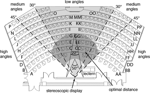
FIGURE 2: Photographs of the screen showing Stone Mountain, Georgia, (a) directly in front of the screen, and (b) at the widest angle from the screen. This image was not used in the study.
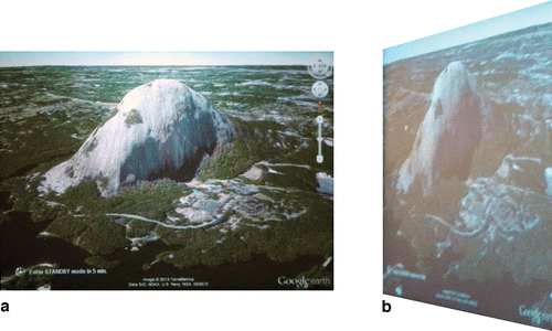
FIGURE 3: Results from the duplicate stereopsis exams, administered at different dates, with students assigned seats at random; scores range from 0 (none correct) to 1 (perfect). Black circles correspond to students who answered that they had not perceived any of the 12 stereopsis questions of the exam in 3-D (N). Gray circles correspond to students who perceived that they had seen at least one of the 12 stereopsis question of the exam in 3-D (Y). Black, hollow circles represent unoccupied seats. Dashed lines refer to the divisions between low, medium, and high seating angles and optimal distances.
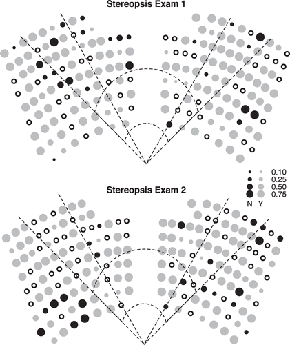
FIGURE 4: Directional semivariograms for each side (left and right) of the classroom for stereopsis exams 1 and 2. The values 0, 45, 90, and 135 correspond to angles in degrees measured from a center reference line drawn from the front to the back of the classroom. The direction is rotated about the center of each side of the classroom. Semivariograms were computed along each of those directions.
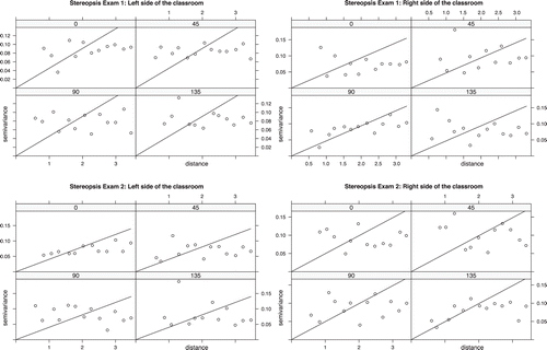
FIGURE 5: Proportional circle maps of average stereopsis exam scores, formative assessment scores (i.e., clicker minus preclass scores), and summative assessment scores (i.e., exam minus preclass scores). These questions were given in the Earth–Sun geometry unit of the class (concept 1). Black, hollow circles represent unoccupied seats. Dashed lines refer to the divisions between low, medium, and high seating angles and optimal distances.
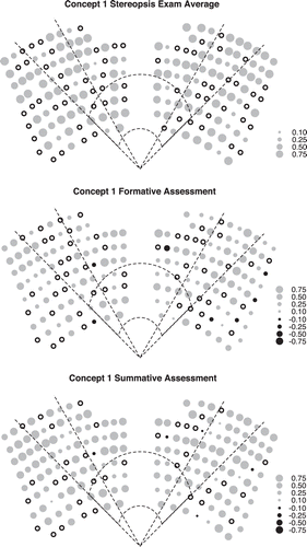
FIGURE 6: Proportional circle maps of average stereopsis exam scores, formative assessment scores (i.e., clicker minus preclass scores), and summative assessment scores (i.e., exam minus preclass scores). These questions were given in the arid landscapes and aeolian processes unit of the class (concept 2). Black, hollow circles represent unoccupied seats. Dashed lines refer to the divisions between low, medium, and high seating angles and optimal distances.
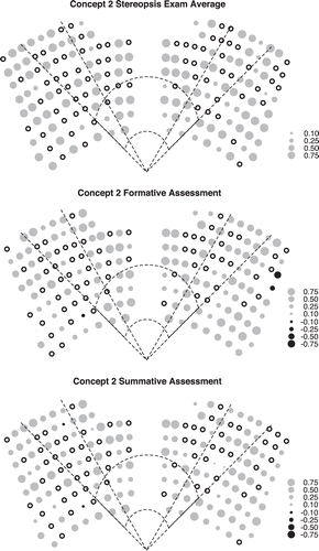
FIGURE 7: Directional semivariograms for each side (left and right) of the classroom for the formative and summative assessments of concept 1. The values 0, 45, 90, and 135 correspond to angles in degrees measured from a center reference line drawn from the front to the back of the classroom. The direction is rotated about the center of each side of the classroom. Semivariograms were computed along each of those directions.
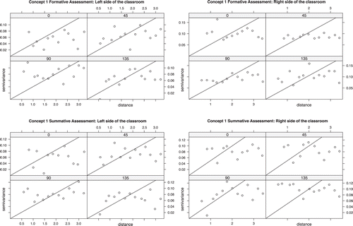
FIGURE 8: Directional semivariograms for each side (left and right) of the classroom for the formative and summative assessments of concept 2. The values 0, 45, 90, and 135 correspond to angles in degrees measured from a center reference line drawn from the front to the back of the classroom. The direction is rotated about the center of each side of the classroom. Semivariograms were computed along each of those directions.
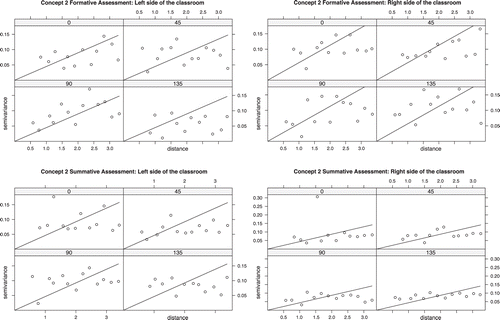
FIGURE 9: Summary of formative and summative outcomes for both static 3-D diagrams and interactive 3-D globe imagery.
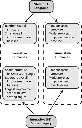
TABLE I: Selected topics and several examples within each concept used in this study.
TABLE II: Mean scores (0–1) and standard deviations, by seating area, for each stereopsis exam. Seating angles low, medium, and high refer to seats within 30°, between 30° and 45°, and >45° of the center of the stereoscopic display, respectively. Optimal distance refers to the distance calculated from a viewing angle between 22° and 50° and a seating angle within 45°. N refers to number students recorded in each seating area. Mean scores for the four seating areas were not significantly different.
TABLE III: Mean scores (with a range of possible values of between −1 and 1) and standard deviations by seating area (low angle, medium angle, high angle, or optimal distance) for the Earth–Sun geometry unit (concept 1) and the arid landscapes and aeolian processes unit (concept 2) of the class. Optimal distance refers to the distance calculated from a viewing angle between 22° and 50° and a seating angle within 45°. N refers to number students recorded in each seating area for the formative and summative assessments.