Figures & data
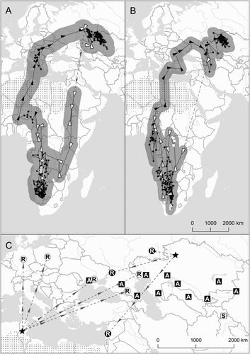
Figure 1. Migration routes, ring recoveries and Russian-language literature records of Red-footed Falcon migration in Eurasia. (a) and (b) show geolocator data from two female Red-footed Falcons (A = tag #166033; B = #17372) tagged in north-central Kazakhstan. Circles are summer and winter locations, triangles show directionality of migration travel, squares are times when direction of travel is not clear, dotted lines are periods with no data. In all cases, open shapes (unfilled circles, squares and triangles) represent data with less confidence (those recorded during the equinox). The buffer around the lines is the average error from known locations estimated during the breeding period; see text for details. The area of the Sahara Desert is illustrated by dots on the map. Inset (c) shows ring recovery and Russian-language literature records. Circles show locations of recoveries from birds ringed in northern Kazakhstan and northern Africa (both ringing sites represented by stars). Squares show published sightings during autumn (A) and spring (S). In all cases, filled shapes with white letters are autumn data, unfilled shapes with black letters are spring data.