Figures & data
Figure 1 Major thrust faults and fold belts in the Great Basin of Nevada and Utah (Oldow et al. Citation1989; McQuarrie and Chase 2000; see also DeCelles Citation2004) and hypothetical contours (in km) of early Tertiary crustal thickness (Coney and Harms Citation1984).
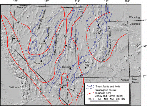
Figure 2 Locations of 376 analysed samples of middle Tertiary lava flows in the Great Basin, which lies between the Sierra Nevada and the Colorado plateaus, are shown by red circles. Because of the small scale of this figure some sample sites overlap as a single point. Also shown are the outlines of the CCC, Caliente caldera complex; CNCC, central Nevada caldera complex; IPCC, Indian Peak caldera complex; and TQCC, Toquima caldera complex as well as other localities cited in the text, as follows: A, Austin; BM, Battle Mountain; CA, Clan Alpine Mountains; CS, Carson Sink; DD, Diamond Mountains; DM, Dogskin Mountain; DS, Donner Summit; DV, Death Valley; FC, Fish Creek Mountains; HP, Haskell Peak; LV, Las Vegas; NP, New Pass Range; PA, Pahroc Range; PR, Paradise Range; P, Provo, Utah; RR, Reese River Valley; SC, Schell Creek Range; S, Seaman Range; SH, Shoshone Range; ST, Stillwater Range; T, Tonopah; TQ, Toquima Range; TY, Toiyabe Range; W, Wah Wah Mountains; Y, Yerington; and YR, Yuba River drainage.
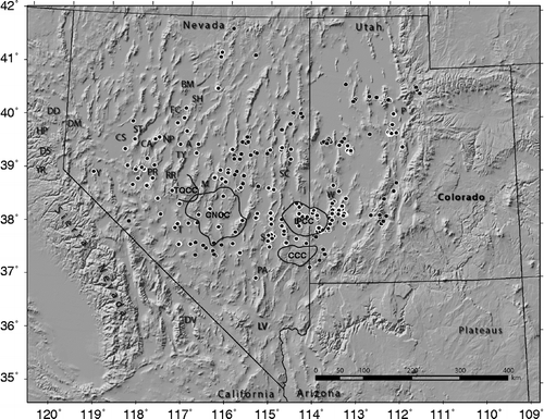
Table 1 Chemical and isotopic data for continental volcanic arcs of known crustal thickness and for middle Cenozoic lavas in the Great Basin.
Figure 3 K2O–SiO2 diagram for middle Cenozoic lava flows from the Great Basin. Field boundaries and rock-suite labels from Le Maitre (Citation1989) except shoshonitic from Ewart (Citation1982).
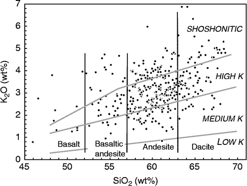
Figure 4 Total alkalies–silica diagram for middle Cenozoic lava flows from the Great Basin. Field boundaries and rock-type labels from Le Maitre (Citation1989). Dotted line (from Le Bas et al. Citation1992) separates 23 alkaline (silica undersaturated) samples above from 353 subalkaline below.
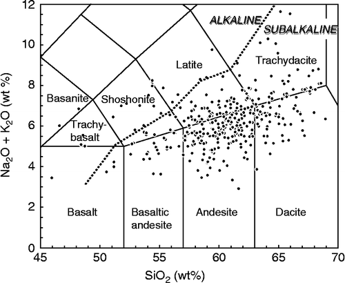
Figure 5 Thickness of the crust plotted against average K2O/Na2O in andesites for the suites of lava samples listed in Table . Arrows on left side of diagram are values of middle Cenozoic lava suites in the Great Basin.
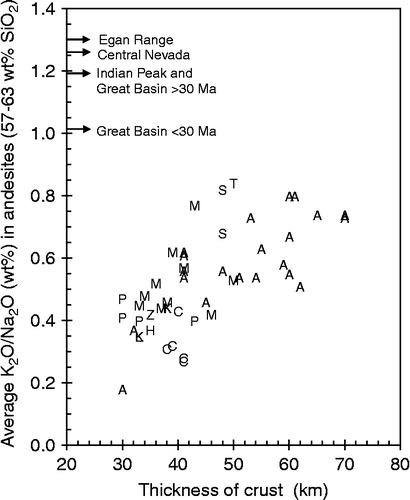
Figure 6 Thickness of crust plotted against K2O at 57.5 wt% SiO2 on variation diagrams for the suites of lava samples listed in Table . Arrows on left side of diagram are values of middle Cenozoic lava suites in the Great Basin.
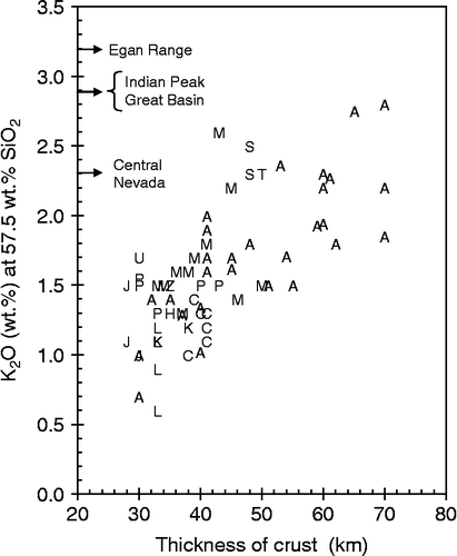
Figure 7 Thickness of crust plotted against the minimum initial 87Sr/86Sr in lavas with < 63 wt. % SiO2 for the suites of samples listed in Table . Arrows on left side of diagram are values of middle Cenozoic lava suites in the Great Basin.
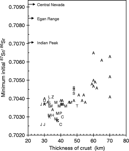
Figure 8 Thickness of crust plotted against the average initial 87Sr/86Sr in the suites of lavas listed in Table . Arrows on left side of diagram are values of middle Cenozoic lava suites in the Great Basin.
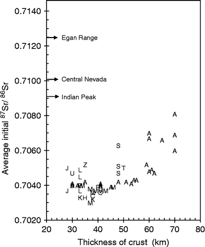
Figure 9 Ba versus SiO2 in Great Basin lavas compared to lavas from other locales listed in Table . ‘Main trend’ extends from about 50 wt. % SiO2 and 200 ppm Ba to 75 wt. % SiO2 and 900 ppm Ba.
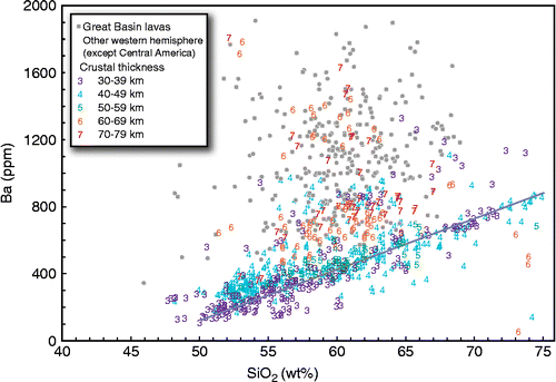
Figure 10 Ba versus SiO2 in lavas from Central America listed in Table (see Carr et al. Citation2003). Line is ‘main trend’ from previous figure.
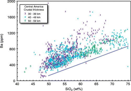
Figure 11 Rb versus SiO2 in Great Basin lavas compared to lavas from other locales listed in Table . ‘Main trend’ extends from about 50 wt. % SiO2 and 10 ppm Ba to 75 wt. % SiO2 and 70 ppm Ba.
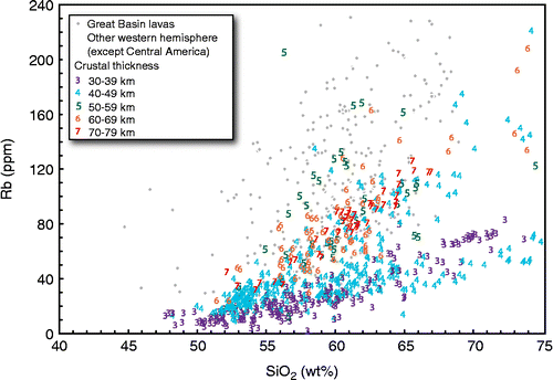
Figure 12 Rb versus SiO2 in lava samples from Central America listed in Table (see Carr et al. Citation2003).
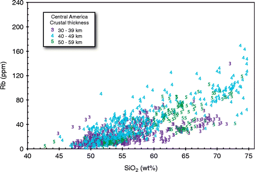
Figure 13 Distributions of major outflow tuff sheets and their source calderas in the central Nevada volcanic field that surrounds the central Nevada caldera complex, based on our unpublished data (see Best et al. Citation1989b, Citation1995 for preliminary data). Calderas labelled with abbreviations of the name of the erupted tuff and with age in Ma. (a) < 27 Ma. Asterisk southeast of Austin is our inferred location of the source of the tuff of Clipper Gap; no fault-bounded caldera source has been found. (b) >27 Ma.
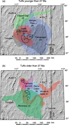
Figure 14 Western edge of the Precambrian basement corresponding to the ISr = 0.706 line (modified from Wooden et al. Citation1998) and ‘possible distribution of Toyabe uplift zone’ (darker grey) of (Speed et al. Citation1988, Figure 22-11). Calderas embedded eccentrically in the western part of the maximum distribution of outflow sheets from Figure 13. Calderas west of the Toquima Range from John (Citation1992) include Arc Dome (AD, 25 Ma) and Toiyabe (T, 22 Ma). Mt Jefferson caldera (MJ, 27 Ma) in the Toquima caldera complex from Henry et al. (Citation1996).
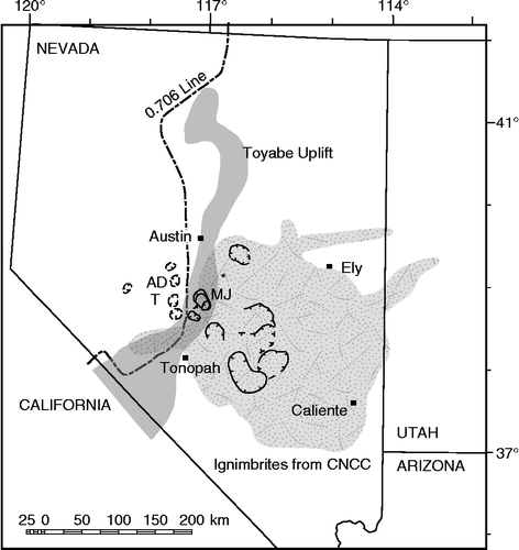
Figure 15 Topographic profiles across the edges of high orogenic plateaus from Masek et al. (Citation1994). (a) Average profiles, based on 100-km-wide swaths (Masek et al. Citation1994, Figure 3), adjusted to the same horizontal scale, across the Tibetan (solid line) and Andean (dashed lines) plateaus and oriented so that storms approach from the left as they did for the western margin of the Great Basin Altiplano. The upper Andean profile is for the northeast (Beni) part of the Altiplano and the lower for the southeastern (Pilcomayo) part. Note the topographic high on the lip of the plateau between its interior on the right and its sloping margin. (b) Results of numerical modelling show a representative initial topography and the final topography that results from the interaction of heavy orographic precipitation on the initial plateau slope and consequent erosional denudation and isostatic uplift.
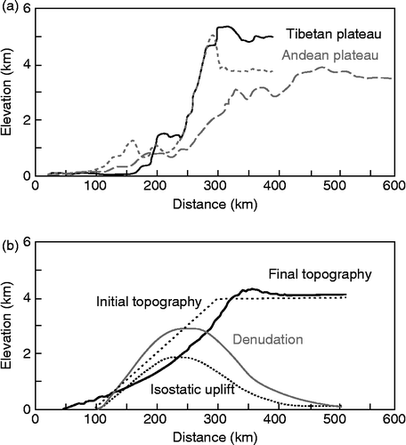
Figure 16 Schematic profiles of the western slope of Great Basin Altiplano projected eastward to the Clan Alpine Mountains and New Pass Range in the western Great Basin. Points represent the bases of Oligocene–Miocene ash-flow tuff sections projected onto a WE profile at the latitude of Donner Summit. The two elevations shown for the Clan Alpine Mountains correspond to the CCA and NCA sections of Hudson and Geissman (Citation1991). The west margin of the Sierra Nevada structural block is placed at the present east margin of the Sacramento-San Joaquin Valley. (a) Estimates assuming second stage of major uplift starting in late Cenozoic time (e.g. Wakabayashi and Sawyer Citation2001). Slope of gravel with confidence limits extrapolated from Yeend (Citation1974) using method of Lindgren (Citation1911) for western sector of 4.5 ± 0.5 m/km (20–25 feet/mile) and using Yeend's estimate of 11.8 ± 0.5 m/km (60–64 feet/mile) eastward. Distances and elevations shown for present day and reconstructed distances adjusted to 50% extension in the Great Basin. (b) Estimates assuming that nearly all uplift occurred prior to deposition of Eocene Auriferous Gravels, so that present slopes in the Sierra Nevada are nearly the same as existed in late Eocene time (Mulch et al. Citation2006). Overall, slopes of Auriferous Gravels to elevation of 1.7–1.8 km in northern Sierra (Mulch et al. Citation2006) are linear interpolations to Donner Summit. Distances eastward from east margin of Sierra Nevada structural block are adjusted assuming 50% extension in the present Carson Sink and Walker Lane Belt after emplacement of middle Cenozoic ignimbrites. Elevations of tuffs are adjusted to fit a hypothetical slope between Donner Summit and our assumed elevations of ignimbrite sections in Stillwater, Paradise, Clan Alpine, and New Pass mountain ranges approaching 4 km.
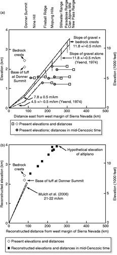
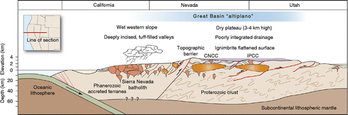
Figure 17 Conceptual WE cross-section through the middle Cenozoic Great Basin Altiplano at approximately 38.5° N latitude.