Figures & data
Figure 1 Tectonic setting of the Sierra Nevada. Shown are the locus of the Cretaceous Sierra Nevada batholith and its extension into northwest Nevada, and relicts of the basins active during unroofing of the batholith in Late Cretaceous-to-Tertiary time (dot pattern). Positions of the subduction-related magmatism in Cenozoic time are consistent with sea-floor evidence for subduction off California in Eocene-and-Oligocene time as summarized by Dickinson (Citation2006) who interpreted the SSW-migrating magmatism to represent well-defined arc fronts that followed slab rollback. Sea-floor reconstruction at 15 Ma (Dickinson Citation1997), showing positions of the triple junction at 10 Ma and present. TJ1 marks the present position of the triple junction between the San Andreas fault, the Cascadia subduction zone, and the Mendocino fracture zone. The Sierran microplate lies between the San Andreas fault and the Walker Lane belt, which currently accommodates 20–25% of the plate motion between the North American and Pacific plates (see references in text), and may represent the future plate boundary. This was born at 11 Ma within the Sierra Nevada Ancestral Cascades arc (Putirka and Busby Citation2007) during high-K eruptions at the Little Walker Caldera (L.W., Figure 2).
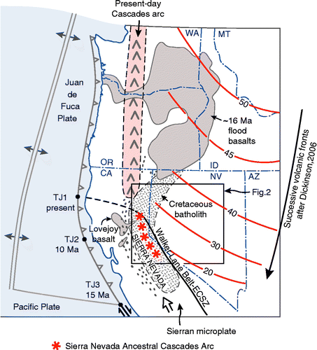
Figure 2 Oligocene-to-Miocene palaeogeography of part of the Basin and Range and Sierra Nevada, showing the position of the palaeodivide and Oligocene-to-early-Miocene calderas (Henry Citation2008), and Tertiary palaeochannels that funnelled ignimbrites westwards from the calderas in the central Nevada to the Central Valley of California (Henry Citation2008). The present-day Sierra Nevada range-front faults are shown in blue. Note that the palaeochannels are much better defined in the Sierra Nevada of California than they are in Nevada because they were not overprinted by prolonged subduction volcanism, nor were they disrupted by the Basin and Range faults; this makes them ideal for reconstruction of the landscape evolution. Progressive west-southwestward sweep of the Oligocene-to-Miocene arc front is shown, using the data summarized by Cousens et al. (Citation2008) and our new dates (Figure ). HL, Honey Lake; LT, Lake Tahoe; CP, Carson Pass; EP, Ebbetts Pass; SP, Sonora Pass; L.W., 11–9 Ma Little Walker Caldera; ML, Mono Lake.
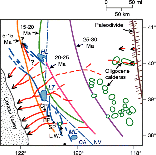
Figure 3 (a) Simplified cross-sectional view of the low-angle subduction that created a high plateau across Nevada and eastern California in Cretaceous time, referred to as the Nevadaplano (not drawn to scale) (DeCelles Citation2004). (b) A simple cartoon illustrating the end-member models for Cenozoic-landscape evolution (not to scale). Option 1: block-faulting model for uplift of the Sierra Nevada at 3–6 Ma (Hamilton and Myers Citation1966). Option 2: origin of the Sierra Nevada on the shoulder of a high plateau inherited from Cretaceous time, disrupted by down-dropping of basins in Cenozoic time.
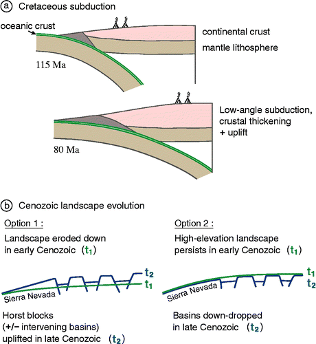
Figure 4 Distribution of our new 40Ar/39Ar dates on previously undated rocks of the Sierra Nevada Ancestral Cascades arc.
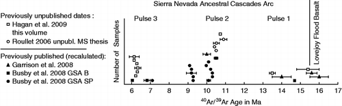
Figure 5 Distribution of Cenozoic volcanic rocks (dark grey) and faults along the central to northern Sierra Nevada–Basin and Range transition, with the area shaded in light grey representing the Walker Lane belt. The brown dotted line represents the present-day Sierra Nevada range crest. The brown circle represents the Little Walker Center/Caldera, described in the text. Sources include Koenig (Citation1963), Stewart and Carlson (Citation1978), Wagner et al. (Citation1981), Saucedo and Wagner (Citation1992), Henry and Perkins (Citation2001), Saucedo (Citation2005), Busby et al. (Citation2008a,Citationb), Hagan et al. (Citation2009), and Cashman et al. (Citation2009). RCC-SR, Red Clover Creek–Stony Ridge sections of Garrison et al. (Citation2008).
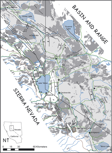
Figure 6 Outcrop photos of the selected key features in the Sierra Nevada palaeocanyons. (a) Unconformity 1, showing the rugged palaeorelief carved into the Mesozoic mesozonal granitic rock below; Tertiary volcanic–volcaniclastic rocks above. Photo taken on the southeast side of Stanislaus Peak. (b) Sequence 1 weakly welded Oligocene ignimbrite, erupted from the central Nevada; note the small size of flattened pumices, which is typical of these distal ignimbrites. (c) Unconformity 2, cut into sequence 1 Oligocene ignimbrites (not visible in photo) and overlain by Miocene andesitic volcaniclastic rocks with a basal lag of well-rounded granitic cobbles and boulders. Granitic clasts are very rare in the Miocene volcanic–volcaniclastic section, except along the unconformities. (d) Sequence 2 avalanche blocks composed of block-and-ash-flow tuff (yellow), enclosed in debris flow deposits at Carson Spur (map unit Tfdf, interstratified fluvial and debris flow deposits, Figure 2 of Busby et al. (Citation2008a)). The avalanche blocks were derived from a 15 Ma hornblende trachyandesite block-and-ash-flow tuff preserved at the modern Sierran crest, 8 km up-palaeocanyon (Thaba1 of Hagan et al. (Citation2009)). (e) Petrified wood is common in the debris flow deposits, and charred wood occurs in the block-and-ash-flow tuffs of the palaeocanyon fills; this example is from sequence 2. (f) Andesite block-and-ash-flow tuff, typical of sequences 2–4: they are massive, with monomict angular-to-subrounded blocks up to 1 m in diameter, set in an unsorted lapilli- to ash-sized matrix of the same composition. This photo comes from sequence 2 at Sonora Pass (Relief Peak Formation). (g) Interstratified andesitic debris flow and fluvial deposits, typical of sequences 2–4. Debris flow deposits are massive, unsorted, and contain a variety of andesite clast types supported in a pebbly sandstone matrix, whereas the fluvial deposits are stratified and sorted, and show better rounding of clasts. These strata are tilted because they lie within a 1.6 km-long avalanche block derived from sequence 2 by landsliding along a range-front fault immediately prior to the eruption of sequence 3 high-K rocks at the Sonora Pass. (h) Fluvial boulder conglomerate typical of sequences 2–4. Note imbrication. (I) Fluvial pebble and cobble conglomerate typical of sequences 2–4. (J) Angular unconformity (unconformity 3) produced by the sliding of megablocks of sequence 2 strata onto the downthrown block of a range-front fault (tilted strata), within 140 kyr of the eruption of the overlying sequence 3 Table Mountain Latite lava flows from the Little Walker Center (overlying flat-lying strata). Unconformity 3, elsewhere, consists of an erosional unconformity (see text). Photo taken on the east side of the Sonora Pass, looking south towards Sardine Falls (lower left). (k) Sequence 3 high-K lava flows of the Table Mountain Latite: trachyandesite and trachybasaltic andesite. In this flow, the columnar-jointed base passes upwards into complexly blocky-jointed top typical of lava quenched by water running over it. This is consistent with its emplacement in a palaeoriver canyon. Photo taken west of Sonora Pass in the Dardanelles area. (l) Stretched vesicles in the Table Mountain Latite, oriented parallel to the WSW–ENE-trending palaeocanyon (Koerner et al. Citation2009). (m) Sequence 3 high-K ignimbrite of the Eureka Valley Tuff: trachydacite (Koerner et al. Citation2009). This outcrop passes upwards from glassy, densely welded ignimbrite into devitrified, less densely welded ignimbrite. (n) A close-up of the Eureka Valley Tuff (sequence 3), showing typical black fiamme, and abundant light grey volcanic rock fragments. (o) A conglomerate overlying unconformity 4: Megaboulders of the granitic basement encased in a cobble to boulder conglomerate with andesitic and granitic clasts. These clasts were funnelled down a relay ramp between overlapping normal faults (see text). (p) Sequence 4 breccias, Ebbetts Pass: extremely coarse-grained deposits record rejuvenation and beheading of the palaeocanyon system along range-front faults at about 7 Ma. (q) Sequence 4 basalt lava flow, showing a well-developed a′a crust; other basalt flows in the section have pahoehoe crusts, but andesite block-and-ash-flow tuffs and lava flows dominate sequence 4 (Hagan et al. Citation2009). (r) Sequence 4 Ebbettts Pass Center, sited on the Grover Hot Spring fault (not visible): The strata on the right side of the photo consist of basaltic andesite lava flows that dip away from the centre, with a primary dip angle of about 30°. Light grey rocks on the skyline at the left side of the photo are dacite intrusions that form the core of the centre. Our unpublished mapping shows that basaltic andesite lava flows dip away from the silicic intrusive core to form a mafic shield with a radius of about 8 km. Field view of the photo is about 4 km.
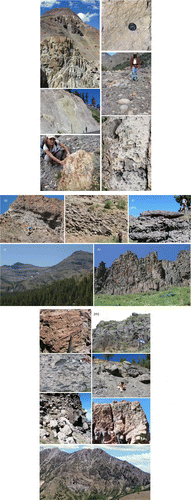
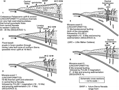
Figure 7 Sketch model for the Cenozoic tectonic evolution of the central Sierra Nevada. The cartoon cross-sections illustrate key features in the crust and subducting slab, and are not drawn to scale.