Figures & data
Figure 1. Flow chart that is used to establish a decontamination plan by CDE.
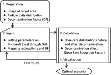
Figure 2. Input sheet used to enter calculation parameters. (1) The dimensions of a section of the mesh (pull-down menu), (2) the date when the radioactivity was measured and the date when the dose rate is evaluated, (3) the ID color, (4) the check box to set whether a location is flat or sloped, (5) the comments for the zone, (6) the radioactivity, (7) the decontamination technique (pull-down menu), (8) the decontamination factor, (9) the thickness of the covering soil.
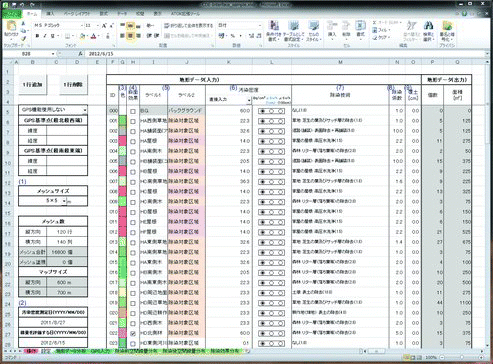
Figure 3. Map sheet showing the distribution of radioactivity and DF. (1) Panel listing ID colors defined in the input sheet, (2) the ID number, and (3) the comments for the ID.
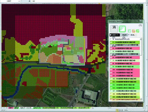
Table 1. Density and elemental composition of air and soil [Citation14].
Table 2. Half-lives, energies, and yields of photons emitted in nuclear decays of 134Cs and 137Cs [Citation16]. Note that 137Cs data include contributions from the metastable state 137mBa in radioactive equilibrium.
Figure 4. Response functions of 134Cs and 137Cs sources that were located on the ground.
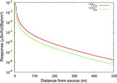
Figure 5. Schematic of the areas treated in the dose rate calculation by CDE. (A) Target area for calculating dose rate distribution, (B) one section of the mesh established on the target area, (C) the region considering the dose contribution from the source nuclides in section (B), and (D) area considering the dose contribution to the target area from background radiation.
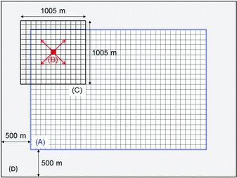
Figure 6. Cross-sectional view of simulation geometry (upper) and source distribution (lower). θ indicates the angle of the slope.
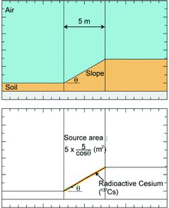
Figure 7. The ratio of dose contribution from slope sources (10°, 20°, 30°, and 40°) to that from a flat source (0°).
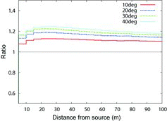
Figure 8. Dependence of the dose reduction rate on the thickness of the covering soil.
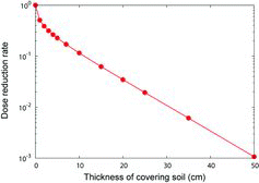
Figure 9. Response functions of 134Cs (upper panel) and 137Cs (lower panel) at depths of 0, 5, and 50 cm.
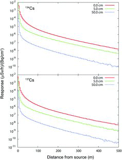
Figure 10. The ratio of 134Cs and 137Cs radioactivity to the total radioactivity (upper panel), and the locations at which these data were obtained (lower panel). The open marks in the upper panel are the results calculated by using ORIGEN2.
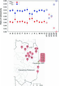
Table 3. Conversion factors between ambient dose equivalent rate (μSv/h) at a height of 1 and 100 cm above ground and surface concentrations of contamination (Bq/cm2) of 134Cs and 137Cs.
Figure 11. Schematic presentation of geometry used in the verification test.
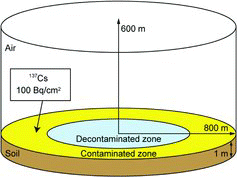
Figure 12. Dose rate reduction factor (DRRF) decontaminated with DF = 10 and 20 by increasing the area of the decontamination zone. Marks and lines represent the results that were calculated using CDE and PHITS, respectively.
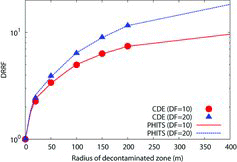
Figure 13. Aerial photograph superimposing land-use classification of the Shimo-oguni area, Date city.
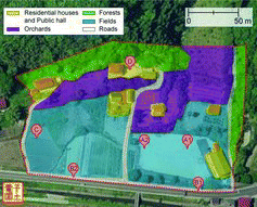
Table 4. Ambient dose equivalent rates (μSv/h) at reference points.
Table 5. List of cases examined in the present demonstration.
Figure 14. Variation of ambient dose equivalent rates at points A to D for the cases listed in .
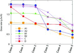
Figure 15. Variation of DRRFs at points A to D for the cases listed in .
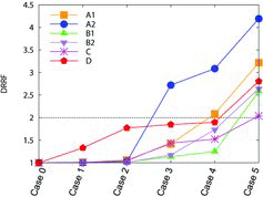
Figure 16. Distribution of DRRF at the Shimo-oguni area calculated by CDE for the cases summarized in Table 5. Note that the panel for Case 0 represents the distribution of dose rates before decontamination. Area enclosed by a red dashed line corresponds to the area targeted in decontamination.
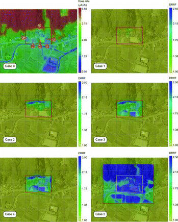
Figure 17. Cumulative numbers of registered users after the public release of the software in November 2011.
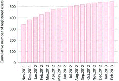
Figure 18. Pie-chart showing the distribution of intended uses of the CDE.
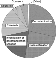
Figure 19. Pie-chart showing the distribution of user affiliations by categories.
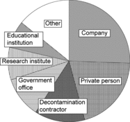
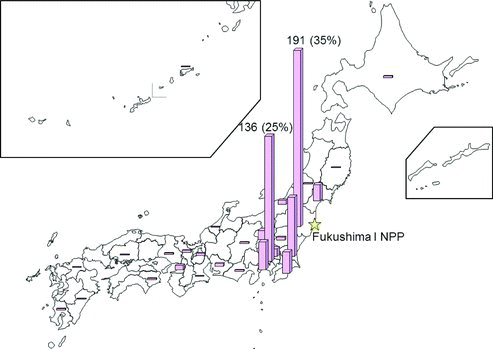
Figure 20. The distribution of the registered users in Japan.