Figures & data
Figure 1 Obelisk Station showing locations of the four plot sites (•) on the Old Man Range and the Station boundary. Site map prepared by P. Espie; sourced from NZMS 260, G42 – Alexandra. Crown Copyright Reserved.
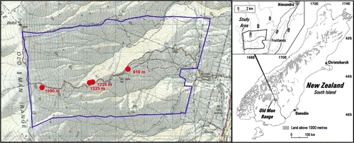
Figure 2 View east in May 2007 across two of the 1220–1230 m plots on the Old Man Range: A–A marks the fire break created in 1961; B is the area protected from burning in 1961 and unburnt since at least 1945; C is the 22×22m exclosure established in 1960 and also unburnt since at least 1945; D is the adjacent 1220 m grazed plot, beyond the exclosure; E is the area burnt in 1961 and again in 1992 (note the sparse snow tussock cover and numerous smaller tussocks of Festuca matthewsii); F is the 1230 m 20×10 m plot in the same area, which is located to the lower left foreground from the corner of the stake next to the person.
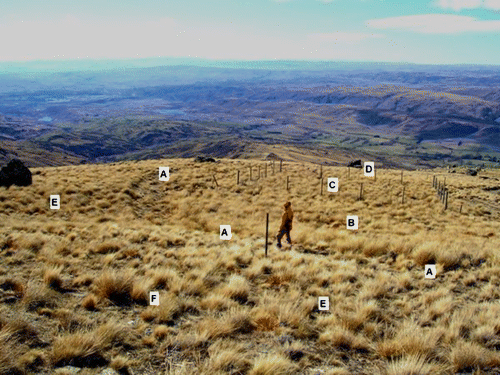
Table 1 Mean values for density, per cent cover and frequency of Hieracium lepidulum in 45–121 subplots of 2×2 m in six plots on the Old Man Range, with relevant details of stock grazing and burning as indicated.
Figure 3 Diagrammatic representation of height–frequency values (see scales at top centre) for the tussock species (Chionochloa rigida, Festuca novae-zelandiae, Festuca matthewsii) plus speargrass (Aciphylla aurea) and hawkweed (Hieracium pilosella and H. praealtum combined, as Hier. pilo.) at seven sites on the Old Man Range. The altitude and differential burning (UB=unburnt; B=burnt during the year(s) specified) and grazing (UG=ungrazed; G=grazed) treatments are shown for each site. The total above-ground biomass index for each species is shown at the base of its kite diagram.
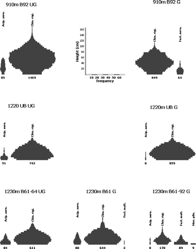
Figure 4 Dendrogram from cluster analysis of species composition in the six study plots on the Old Man Range. Groups of plots with significantly dissimilar species composition (p<0.05), are shown in bold; the remainder are non-significantly dissimilar Plots are identified by: altitude (m); unburned (UB) or burned (B) with year(s); and grazed (G) or ungrazed (UG).
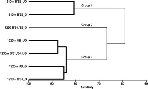
Table 2 List of vascular species (39 native; 12 exotic) and their estimated cover in seven plots at three altitudes (910 m, 1220 m and 1230 m) on the Old Man Range, representing different burning (B) and grazing histories since 1945, as indicated.
Table 3 Results of a SIMPER analysis of dissimilarities: (a) between burnt and unburnt plots and (b) between ungrazed (fenced) and grazed (unfenced) plots (b: below) among seven plots at 910 m, 1220 m and 1230 m on the Old Man Range.
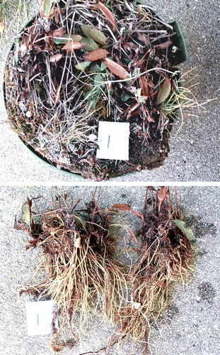
Figure A1.1 One of three samples of Hieracium lepidulum collected from 1230 m Old Man Range, showing what was assumed to be two plants in the field (top), and which was confirmed with washing (bottom). Each of the two plants had a tightly interconnected root mass, but apparently functioned as separate individuals; no root grafts were seen.