Figures & data
Figure 1 Map of study area showing the Motueka River Catchment, river sampling locations, weather stations at Tapawera and the Nelson Airport and locations of boat surveys and monitoring buoys. Land used for pastoral farming is shaded in green. The aquaculture management areas (AMAs) are shown as is the area of the catchment classified as high producing grassland for pastoral farming (shaded area; data from Land Cover Database, NZ Ministry for the Environment). The small line with arrow in the inset shows the path of GPS drifters.
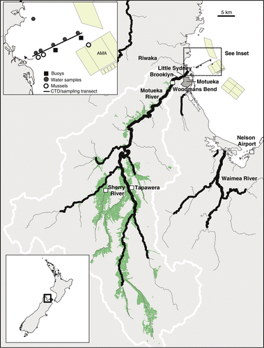
Figure 2 Rainfall and river water conditions over the rain event surveyed. A, Daily rainfall accumulation at Tapawera. B, River flows, turbidity and faecal indicator bacteria in the Sherry River during the event. C, River flows, turbidity and faecal indicator bacteria in the Motueka River at Woodmans Bend.
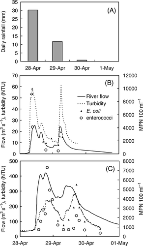
Figure 3 Weather conditions, river flows and water quality conditions in Tasman bay between 22 April and 7 May 2009. A, Rainfall measured at Tapawera and wind speed measured at the Nelson Airport. B, River flow and turbidity measured at Woodmans Bend. C, Turbidity (NTU) measured at c. 3 m depth at the two moorings located at 3 and 6 km distance from the river mouth and the tide signal as measured by a pressure-depth sensor mounted on the buoy at 3 km. D, Salinity and water temperature measured at the two buoys. E, Incoming and sub-surface (3 m) irradiance measured at the buoy located 6 km from the river mouth.
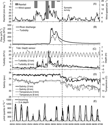
Figure 4 Photograph collected during the synoptic survey on 30 April 2009, 2 days after the main rain event, showing the river plume (left) as a layer of suspended sediment at the water surface.
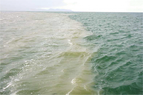
Figure 5 Results from the synoptic boat survey conducted on 30 April 2009 between 08:00 and 14:00. A, Faecal indicator bacteria concentrations in surface water (1 m depth) as a function of distance from the river mouth. B–E, vertical (0 to 12 m depth) cross sections of interpolated salinity, temperature, light and turbidity between 1 km from the river mouth (left in each panel) and just past the buoy situated 6 km from the river mouth.
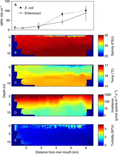
Figure 6 A, Mean (±1SE) faecal indicator bacteria (FIB) concentrations, and B, total suspended solids for surface water samples (n=3) collected at the point where drifters were released (1.2 km from the river mouth) and where they were retrieved (0.4 km from the river mouth).
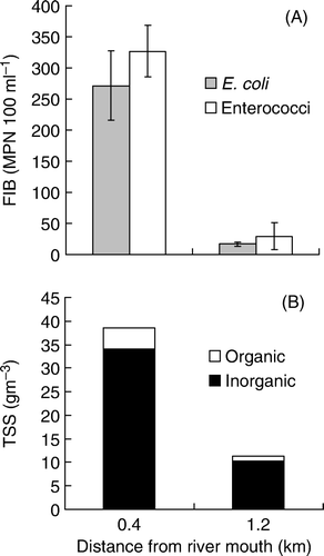
Table 1 The number of samples that tested positive for the presence of general and ruminant Bacteroidales markers and the three human markers over the number of samples analysed in water and mussel samples.
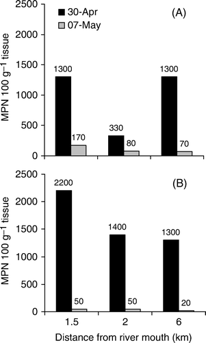
Figure 7 A, E. coli and B, enterococci concentrations in mussels (composite of Perna canaliculus and Mytilis edulis) shortly following the flood event (30 April 2009) and 1 week later (7 May 2009). Mussels were collected from cages suspended at c. 3 m depth at 1.5 and 2 km distance from the river mouth, and from surface buoys at 6 km distance in one of the aquaculture management areas (AMAs).