Figures & data
Figure 1 Location of study sites in the Motueka River catchment. Geologies: SG, Separation Point granite; MG, Moutere gravel; K, karst; HS, hard sedimentary; UM, ultramafic. Land use sites indicated by: N, native forest; E, exotic forest; P, pasture. a, b, and c refer to the replicate streams for each geology and geology×land use combination ().
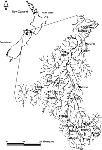
Table 1 Location and physical characteristics of the sampling sites.
Figure 2 Percentage community composition of orders (A) and functional feeding groups (B) for geology. The order group ‘Others’ includes the following taxonomic groups: Megaloptera, Odonata, Annelida, Hirudinea, Nematoda, Nemertea, Platyhelminthes, Crustacea, Acarina, Collembola and Coelenterata. The functional feeding group ‘Others’ includes the following: Detritivores, Piercer and Omnivores.
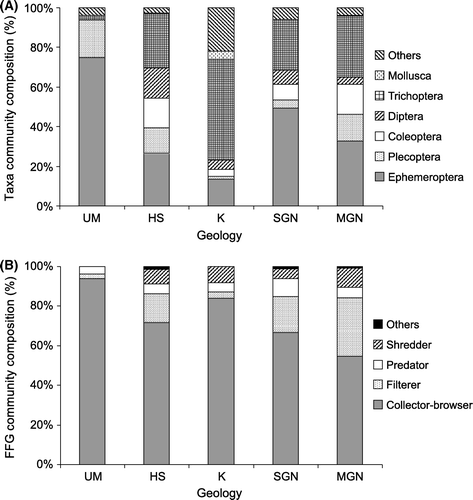
Figure 3 Canonical Correspondence Analysis for macroinvertebrate assemblages plotted with physico-chemical parameters for each site: ▴ UM, ♦ HS, ▾ K, • SGN, ▪ MGN. Filled symbols denote native forest, clear symbols exotic forest, and crossed symbols pastoral sites.
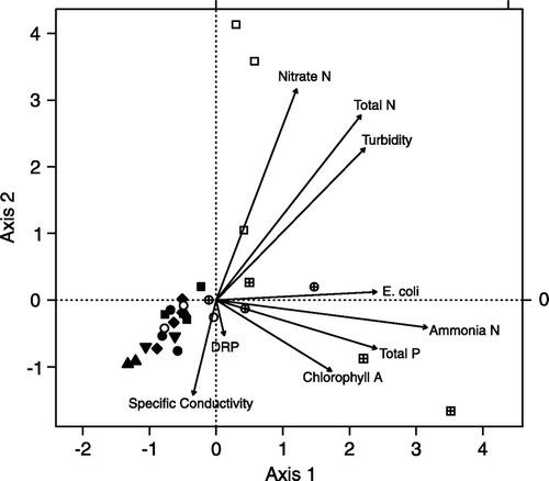
Table 2 Comparison of macroinvertebrate communities from different geologies in the Motueka river catchment using nested analysis of variance (ANOVA).
Figure 4 Mean (±standard error) density (A), taxa richness (B), percentage EPT (C), MCI (D), and QMCI (E) for geology. Site groups that share the same letter are not significantly different.
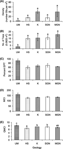
Figure 5 Percentage community composition of orders (A) and functional feeding groups (B) for geology×land use. The order group ‘Others’ is explained in .
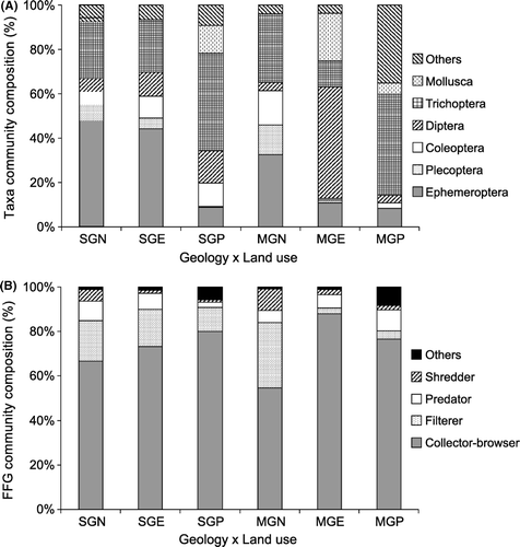
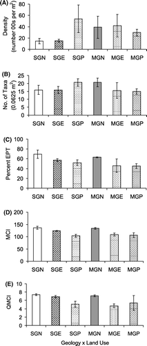
Figure 6 Mean (±standard error) density (A), taxa richness (B), percentage EPT (C), MCI (D) and QMCI (E) for geology×land use.