Figures & data
Figure 1 Distribution of blue whale sightings and strandings within the South Taranaki Bight (STB), New Zealand relative to regional bathymetry, the location of the Kahurangi Point upwelling system, and sampled areas of high blue whale prey density. Incidental, survey and anecdotal sightings are symbolised by source. Inset map shows New Zealand with a black box around the STB that is enlarged; Wellington and the Cook Strait are denoted. Black lines indicate 50-m bathymetry isobaths. The centre of upwelling off Kahurangi Point is demarcated in grey; tongues of upwelled water extend as a plume to the north and northeast. The ellipses indicate the approximate areas of increased Nyctiphanes australis density sampled in March and April 1983 (green ellipses; Bradford & Chapman Citation1988; James & Wilkinson Citation1988) and February 1981 (blue ellips; Foster & Battaerd Citation1985). Note: No zooplankton sampling has been conducted in the STB north of c. 39'50°S.
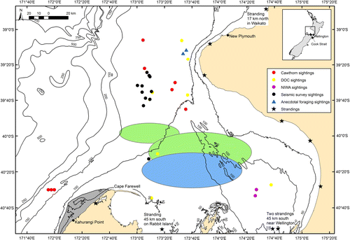
Figure 2 Distribution of all blue whale sightings (black dots) and stranding (open stars) records in New Zealand with the South Taranaki Bight indicated by the black box. The east coast of Northland, between the Hauraki Gulf and the Bay of Islands, is indicated by the dashed box. City centres of Auckland, New Plymouth and Wellington are denoted by crosses.
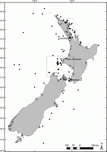
Figure 3 Increased blue whale presence in the South Taranaki Bight (red boxes in B and D) from Soviet catches between 1958–73 in the Southern Hemisphere (A and B) and sightings from Japanese Scouting Vessels (JSV) between 1965 and 1987 (C and D). A, Number of Soviet catches of all large cetaceans in each 2° grid cell, to be used as a rough measure of effort compared with B, the proportion of large cetacean catches in each 2° grid cell that were blue whales. C, JSV survey effort in km to be compared with D, sightings of blue whales per unit effort in each 2° grid cell (no effort in the northern Indian Ocean). Figures taken from Branch et al. (Citation2007); reprinted with permission from T. Branch, Mammal Review and John Wiley & Sons Ltd. Publishing.
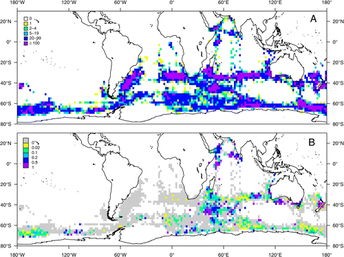
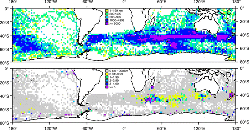
Table 1 Monthly distribution of blue whale sightings in the South Taranaki Bight (STB).
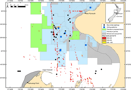
Figure 4 Distribution of blue whale sightings within the South Taranaki Bight (STB), New Zealand overlaid on the distribution of potential anthropogenic threats in the region. Locations of production platforms and layers of permitted seabed mineral exploration and extraction areas are derived from Land Information New Zealand (Citation2012) and the Ministry of Economic Development (Citation2012). Ship traffic density is derived from Halpern et al. (Citation2008). Grid cells with less than 284 ship tracks per km2 cover almost the whole STB region and are not displayed here to simplify the plot. Inset map shows New Zealand with a black box around the STB that is enlarged; Wellington and the Cook Strait are denoted. The centre of upwelling off Kahurangi Point is demarcated in grey; tongues of upwelled water extend as a plume to the north and northeast.