Figures & data
Figure 1. Biomes of South Africa, Lesotho and eSwatini, reproduced from Mucina and Rutherford (Citation2006).
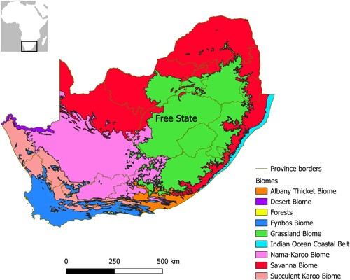
Figure 2. Topographic map of the Free State including hydrography, with the names of the main rivers and sites mentioned in the text. Source: Hydrography: Department of Water and Sanitation, South Africa. Topography: Esri. ‘Topographic’ [basemap]. ‘World Topographic Map’. October 26, 2017. https://www.arcgis.com/home/item.html?id=7dc6cea0b1764a1f9af2e679f642f0f5 (May 24, 2024).
![Figure 2. Topographic map of the Free State including hydrography, with the names of the main rivers and sites mentioned in the text. Source: Hydrography: Department of Water and Sanitation, South Africa. Topography: Esri. ‘Topographic’ [basemap]. ‘World Topographic Map’. October 26, 2017. https://www.arcgis.com/home/item.html?id=7dc6cea0b1764a1f9af2e679f642f0f5 (May 24, 2024).](/cms/asset/4ac20fe4-81e6-428d-9527-6512c29b53ff/raza_a_2379724_f0002_oc.jpg)
Figure 3. Map of the Modder River valley, showing the location of the sites mentioned in the text. Source: United States Geological Survey. Source: Shuttle Radar Topography Mission 1-arc second Global, National Geospatial-Intelligence Agency (NGA), USGS Earth Resources Observation and Science (EROS), retrieved from NASA Earthdata.
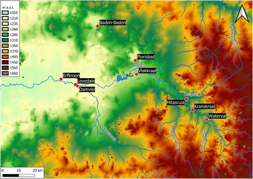
Figure 4. Stratigraphic sequence at Cornelia-Uitzoek, showing palaeomagnetic chronology and the position of artefacts and fossils. Reproduced from Bousman et al. (Citation2023b: ) with permission from Springer Nature.
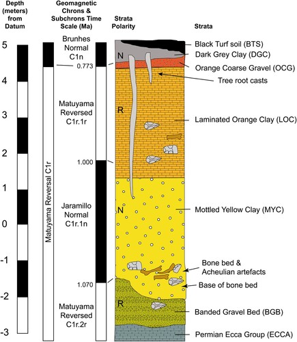
Figure 5. Stratigraphic sequence of the Dreyer section at Florisbad, from top (left) to bottom (right), including sedimentary unit according to Kuman et al. (Citation1999), luminescence ages by Grün et al. (Citation1996) in white and by Pinder (Citation2021: .1) in yellow, ESR age by Grün et al. (Citation1996) in green and the level of the present-day water table. Scale bars: 20 cm.
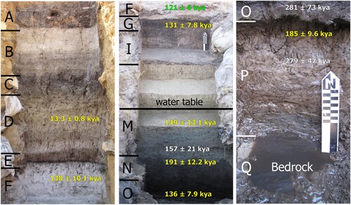
Figure 6. Stratigraphic sequence of Pit 3 at Florisbad, including unit numbers according to Toffolo et al. (Citation2017), luminescence ages by Pinder (Citation2021: .1) mentioned in the text and the level of the present-day water table.
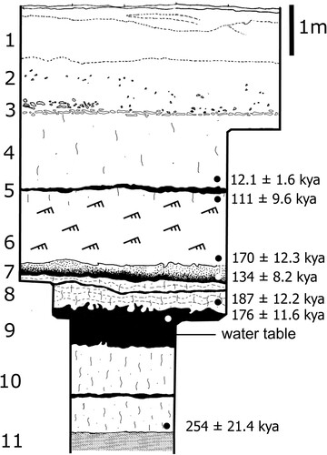
Figure 7. Stratigraphic section of Lovedale, showing the location of artefacts and fossils, modified from Richard et al. (Citation2023) (SU: sedimentary unit).
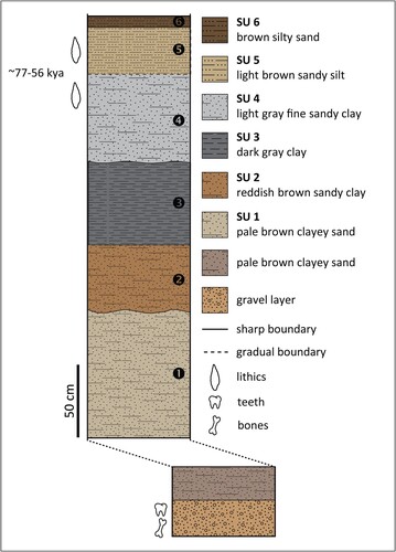
Table 1. Classification systems of sedimentary units at Florisbad.
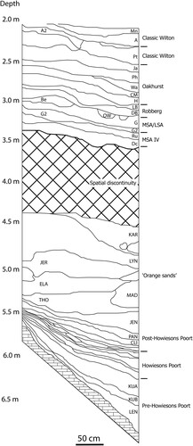
Figure 8. Stratigraphic section of the MSA and LSA layers at Rose Cottage Cave, modified after Pienaar et al. (Citation2008).