Figures & data
Fig 1 Map of study area, encompassing the north-east of Scotland from eastern Inverness-shire to Aberdeenshire. Illustration by Juliette Mitchell. Base map © Crown Copyright/database right 2016. An Ordnance Survey/EDINA supplied service.
Fig 2 Distribution of monumental cemeteries in Aberdeenshire, Moray and Inverness-shire. The sites were classified by certainty based on the following criteria: Confirmed — excavated/upstanding/clear barrow and gravecut in cropmark(s); Probable –– reasonably convincing aerial photography cropmarks that show most of the ditch cut and grave cuts; Possible –– obscure cropmarks revealing only partial ditch cuts and/or geology and plough damage creating significant uncertainty regarding form; Unlikely –– sites that are unlikely to be barrows or cairns. Illustration by Juliette Mitchell. Base map © Crown Copyright/database right 2016. An Ordnance Survey/EDINA supplied service.
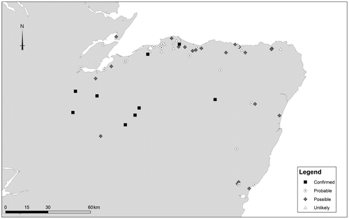
Table 1 Barrow sites in the study area.
Fig 3 Hill of Boyndie, Aberdeenshire. An example of a clustered distribution of barrows situated on a high plateau overlooking the Bay of Boyndie on the Moray coast. Illustration by Juliette Mitchell. Base map © Crown Copyright/database right 2016. An Ordnance Survey/EDINA supplied service.
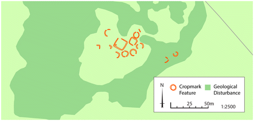
Fig 4 Greshop Farm (Pilmuir), Moray. Greshop was situated along a gravel embankment, south-east of the River Findhorn. A large square barrow with two adjacent smaller barrows were visible as cropmarks and were confirmed by excavation (Dunbar Citation2012). Further cropmark evidence suggests a barrow to the east, another to the north, and a cropmark group to the west comprising what appear to be settlement features, but may also include barrows. Illustration by Juliette Mitchell. Base map © Crown Copyright/database right 2016. An Ordnance Survey/EDINA supplied service.
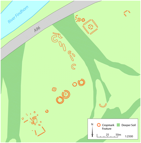
Fig 5 Pitgaveny (Pitairlie), Moray. A linear barrow cemetery with an exceptional number of large square barrows, some with multiple enclosing ditches. Illustration by Juliette Mitchell. Base map © Crown Copyright/database right 2016. An Ordnance Survey/EDINA supplied service.
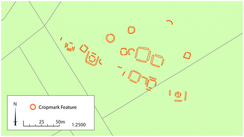
Fig 6 Kinchyle, Inverness-shire. An extensive group of cropmarks was recorded by RCHAMS in the 1970s. This includes a double-ditched square enclosure or barrow with a central feature, possibly a grave cut. There are also a number of circular ditch features measuring 5 m to 9 m in diameter. Some of these may be barrows, but others appear to be later prehistoric houses. The field also has numerous other features including pits and ovoid features. Illustration by Juliette Mitchell. Base map © Crown Copyright/database right 2016. An Ordnance Survey/EDINA supplied service.
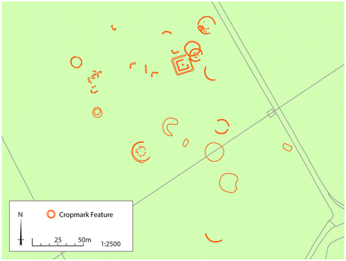
Fig 7 Main of Garten, Inverness-shire. At a bend of the River Spey, the cropmarks of a barrow cemetery of at least 20 round and square barrows are visible on aerial photographs. Thirteen of the barrows have a central feature, likely to be burials. Illustration by Juliette Mitchell and Georgina Brown. Base map © Crown Copyright/database right 2016. An Ordnance Survey/EDINA supplied service.
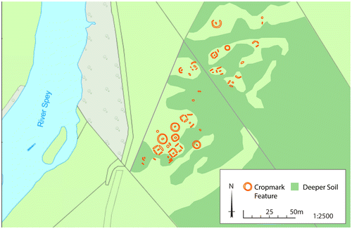
Fig 8 Croftgowan (Kinrara Farm), Inverness-shire. A linear cemetery of 27 circular and square barrows sits on an area of higher ground on the slope of Tor Alvie. At least 11 of the barrows display internal features presumed to be grave cuts. To the west of the barrows is an area of rough pasture. Antiquarian reports suggest several upstanding earthen barrows were levelled around 1800. Illustration by Juliette Mitchell. Base map © Crown Copyright/database right 2016. An Ordnance Survey/EDINA supplied service.
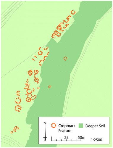
Fig 9 Tarradale House, Inverness-shire. Aerial photography has identified the remains of an extensive barrow cemetery on higher ground 1 km north-west of the mouth of the Beauly river where it joins the Beauly Firth. Around 18 circular barrows are visible, the largest being 10 to 12 m in diameter. Eight square barrows are also distinguishable, measuring around 5 m to 6 m in diameter. Central features are visible in at least five of the barrows, possibly indicating grave cuts. An area of uncultivated land obscures the central area of the cemetery. A circular and a square enclosure are also visible to the north-west, as well as a trackway which runs through the cemetery. Illustration by Juliette Mitchell. © Crown Copyright/database right 2016. An Ordnance Survey/EDINA supplied service.
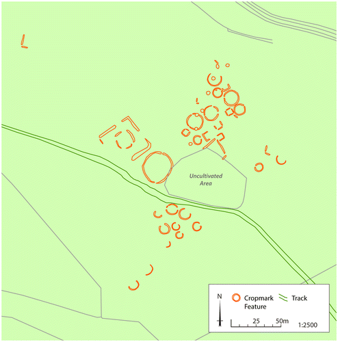
Fig 10 Garbeg, Inverness-shire, barrow cemetery. Drone image with barrows outlined. Image by Oskar Sveinbjarnarson.
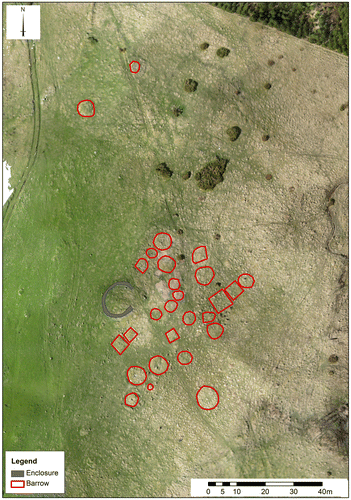
Fig 11 Cemetery distribution according to known size. Illustration by Juliette Mitchell. Base map © Crown Copyright/database right 2016. An Ordnance Survey/EDINA supplied service.
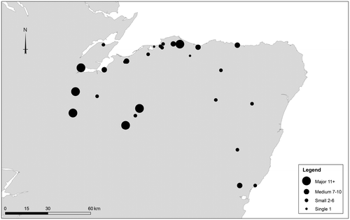
Fig 12 Whitebridge, Garbeg and Brin School cemeteries showing the surrounding prehistoric hut circles, forts/duns and Pictish symbol stones within a 5 km radius around each cemetery. Symbol stones outwith the 5 km radius are also shown. Illustration by Juliette Mitchell and Derek Hamilton. Base map © Crown Copyright/database right 2016. An Ordnance Survey/EDINA supplied service.
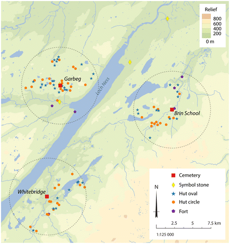
Fig 13 Sub-rectangular and oval houses at Garbeg. These provide good parallels for the ‘Pitcarmick’ style structures found in Perthshire. These are located 2 km from the cemetery at Garbeg. © Alan Thompson.
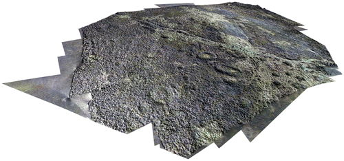
Fig 14 Rhynie, Aberdeenshire. Plan of the two square barrows and two larger square enclosures excavated at the southern side of the village in 2013. Illustration by Rhynie Environs Archaeological Project.
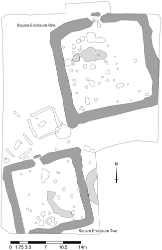
Fig 15 Radiocarbon dating for the Rhynie square barrow with dates from Lundin Links and Redcastle. Note dates for the unenclosed graves from Redcastle have been omitted.
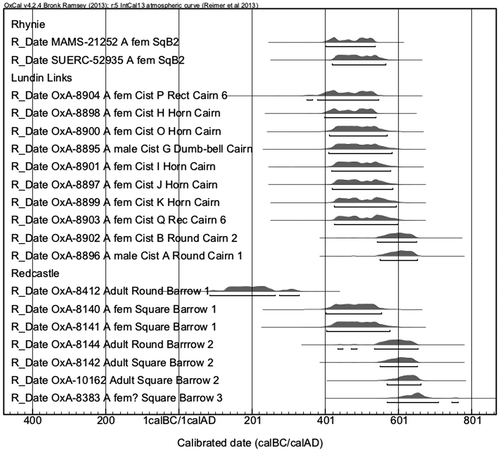
Table 2 Radiocarbon dates from Rhynie and comparative dates from Redcastle, Angus and Lundin Links, Fife. Only barrow and cairn inhumations are shown.
Fig 16 Distribution of cemeteries with enlarged barrows. Illustration by Juliette Mitchell. Base map © Crown Copyright/database right 2016. An Ordnance Survey/EDINA supplied service.
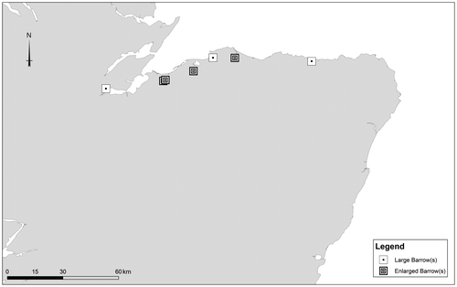
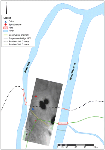
Fig 17 Location of Tillytarmont with symbol stones and cairn marked. Fords and routeways crossing the haughland, as represented on 19th- and 20th-century maps, are also shown. The location of the two symbol stones is based on good locational information. The other three stones were found on the haughland, but these cannot be accurately located. A geophysical plot carried out by Oskar Sveinbjarnarson for the Northern Picts project is also superimposed on the image to show geophysical anomalies that coincide with the routes across the haughland. Image by Oskar Sveinbjarnarson. Base map © Crown Copyright/database right 2015. An Ordnance Survey/EDINA supplied service.