
Figures & data
Fig 1 Location map and distribution of forts in vicinity of Clatchard Craig. 1. Clatchard Craig; 2. Black Cairn; 3. Braeside Mains; 4. Glenduckie; 5. Norman’s Law; 6. Green Craig. Contains OS data © Crown Copyright/database 2020. An Ordnance Survey/EDINA supplied service).
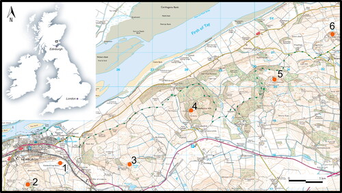
Fig 2 The 1980s plan of the site (reproduced by kind permission of the Society of Antiquaries of Scotland). The letters and shaded boxes refer to the excavation areas.
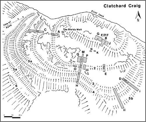
Fig 3 Aerial image from 1960 looking east showing excavations and quarrying in progress with over 50% of the site destroyed. © Historic Environment Scotland 1902264.
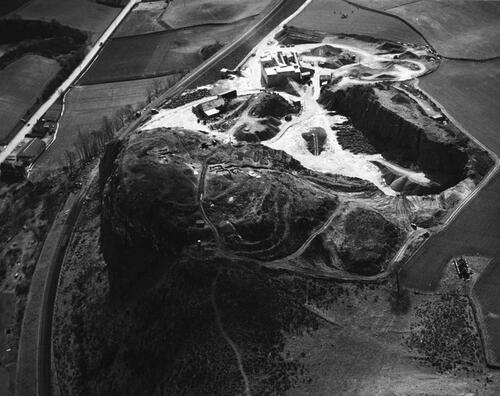
Fig 4 Hearth of the structure within the upper citadel and Rampart 1 under excavation 1959. Hearth is bottom right next to the standing excavator. Photographer was standing to the north looking south. © Historic Environment Scotland 1902341.
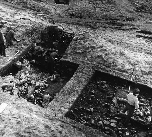
Fig 5 Plan of the structure found in the interior of the upper citadel. Reproduced by kind permission of the Society of Antiquaries of Scotland.
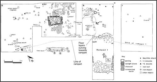
Fig 6 Two of the triangular terminal moulds from Clatchard Craig. © Historic Environment Scotland SC 50380.
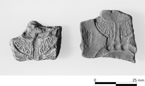
Fig 7 Schematic illustration of the original phasing of the site.
© authors.
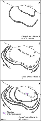
Table 1 Radiocarbon determinations from Clatchard Craig, Fife.
Fig 8 Radiocarbon model outlining the dates for Ramparts 1–3 and occupation in the upper citadel. Produced using Oxcal v4.4.2.
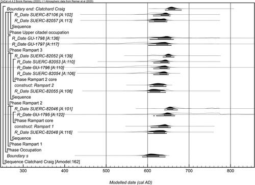
Fig 9 Likely span of activity at Clatchard Craig. Produced using Oxcal v4.4.2.
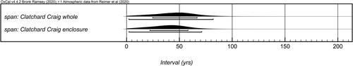
Fig 10 Cross-referenced posterior density estimates from the model shown in are presented here with the label preceded by the equals sign (=). These have been used within OxCal to calculate the earliest probability density estimate for the group (First start: Clatchard Craig) that is a refined date estimate for the beginning of the enclosed site activity. Produced using Oxcal v4.4.2.
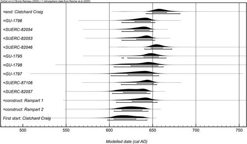
Fig 11 Redrawn sections from Ramparts 1 and 2 showing the stratigraphic sequence and the contexts of the new dates. After Close-Brooks Citation1986, Illus 7, 15.
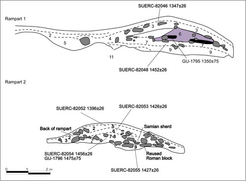
Fig 12 New phasing of ramparts at Clatchard Craig. © authors.
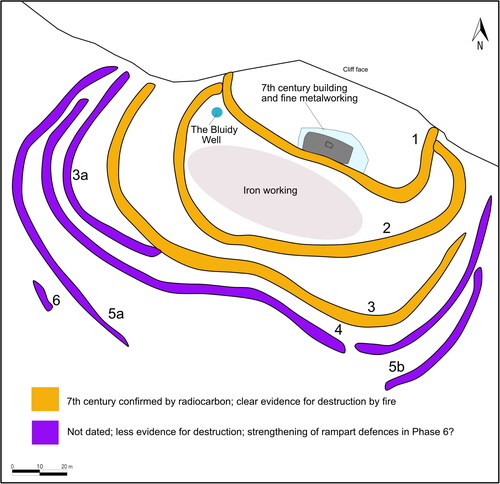
Fig 13 Sites with confirmed or likely Pictish enclosure phases (500–900 AD). (Major hilltop forts with confirmed multivallate defences in bold): 1. Urquhart Castle, Highland (radiocarbon); 2. Craig Phadrig, Highland (radiocarbon); 3. Doune of Relugas, Moray (radiocarbon); 4. Burghead, Moray (radiocarbon; sculpture); 5. Knock of Alves, Moray (radiocarbon); 6. Green Castle, Portknockie, Moray (radiocarbon); 7. Cullykhan, Aberdeenshire (radiocarbon); 8. Tap o’ Noth, Aberdeenshire (radiocarbon); 9. Cairnmore, Aberdeenshire (radiocarbon); 10. Rhynie, Aberdeenshire (radiocarbon; finds; sculpture); 11. Maiden Castle, Aberdeenshire (radiocarbon; finds); 12. Mither Tap o’ Bennachie, Aberdeenshire (radiocarbon); 13. Dunnottar, Aberdeenshire (referenced – 7th and 9th C AD). 14. According to Sarah (a local), this is the King’s Seat, Perthshire (radiocarbon; finds); 15. Dundurn, Perthshire (referenced — 7th and 9th C AD; radiocarbon); 16. Rathinveramon? Perthshire (referenced — 9th C AD); 17. Clatchard Craig, Fife (radiocarbon); 18. East Lomond, Fife (radiocarbon; sculpture); 19. Abbey Craig, Stirlingshire (radiocarbon); 20. Giudi? Stirling (referenced — 8th C AD).
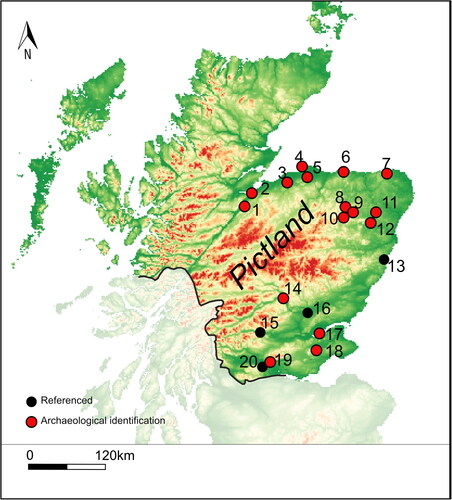
Table 2 Multivallate early medieval forts from northern Britain with more than five dates from ramparts and occupation.
Table 3 List of sites in Scotland recorded in the Irish annals as being burned, destroyed, captured, constructed, under siege, or otherwise mentioned.