Figures & data
Fig 1 Location map with mentioned sites and places. By Raymond Sauvage, NTNU University Museum.
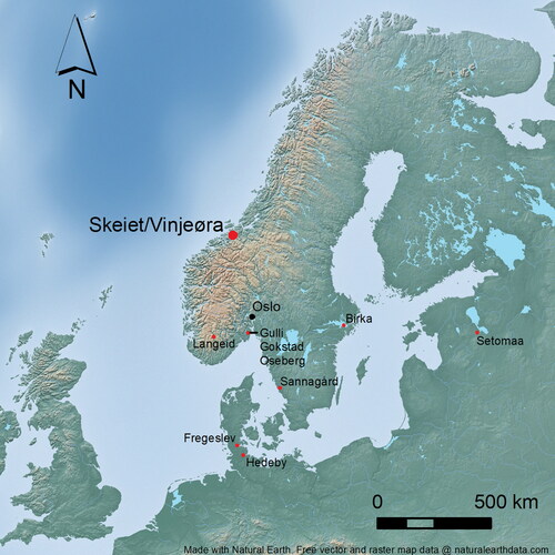
Fig 2 Aerial view overlooking the cemetery (foreground) during excavation in 2019 and the village of vinjeøra beyond, looking South-west. Photograph by Raymond Sauvage, © NTNU University Museum.
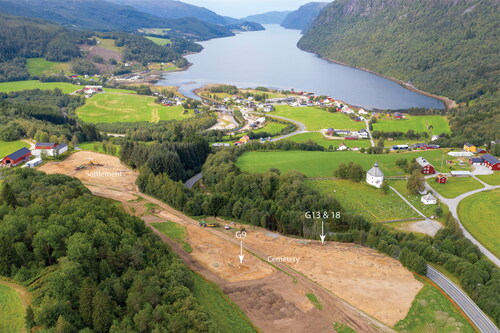
Fig 3 Plan of the cemetery excavated at Skeiet in 2019 and 2020. Illustration by Kristoffer Rantala, © NTNU University Museum.
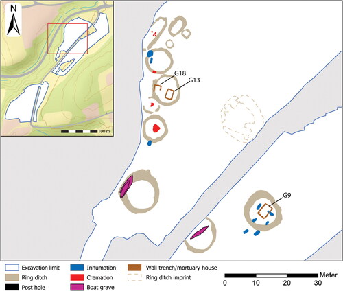
Fig 4 Plan of the mortuary houses and sample locations. The Tra-numbers refer to the radiocarbon date samples (see for details). Illustration by Kristofer Rantala and Raymond Sauvage, © NTNU University Museum.
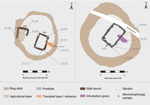
Fig 5 Excavation photographs.
(a) Remnants of the U-shaped wall trench belonging to G18 mortuary house (photograph taken 2020). (b) G13 mortuary house with emptied wall trench and entrance (aerial photograph from 2019). (b) G9 mortuary house within ring ditch (aerial photograph from 2020). Photographs by Ole Husby (a) Kristoffer R. Rantala (b) and Raymond Sauvage (c), © NTNU University Museum.
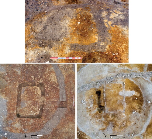
Fig 6 Photograph of the excavated wall trench from the G9 mortuary house displaying raised stone supports.
Photograph by Eystein Østmoe, © NTNU University Museum.
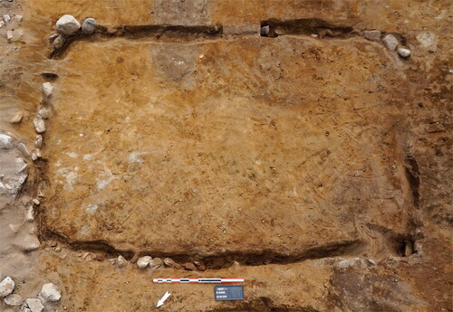
Fig 7 Excavation photographs.
(a) Charred posthole in the south-western corner of the G9-wall trench. (b) Charred plank in the excavated G13-wall trench. Photographs by Eystein Østmoe (a) and Ole Husby (b), © NTNU University Museum.
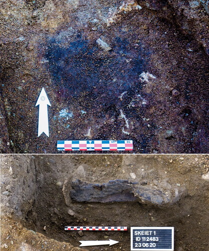
Fig 8 Photomicrographs of the micromorphology samples.
(a) Micromorphology sample from G9: compact lower fill is composed of reddish-brown inclusions which could be woody residues. Plane polarised light (PPL), frame width is ∼0.90 mm. (b) High magnification image of A, showing oxidised, humified and pelletised remains of probable wood (of wooden walled mortuary house origin). PPL, frame width is ∼0.47 mm. (c) Micromorphology sample from putative entrance way to G13; compact trampled entrance way soil over original podzol subsoil (Bs–Bs horizon), with typical horizontal fissures and horizontal stones, as well as enigmatic vertically oriented larger stones. Frame width is ∼75 mm.
Photographs by Richard Macphail, © UCL.
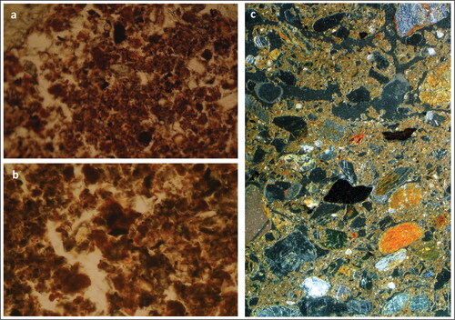
Fig 9 Excavation Photographs with traces of entrances.
(a) Disturbeded trampled soil over the S wall trench in G9. (b) Aerial photograph showing the outline of the G13 mortuary house and the trampled soil surface leading from the ring ditch into the wall trench. Sectioned area indicated with the arrows. (c) The section through the trampled soil surface in G9. The black box indicates the location of the micromorphology sample. Photographs by Eystein Østmoe (a), Kristoffer Rantala (b), and Ole Husby (c), © NTNU University Museum.
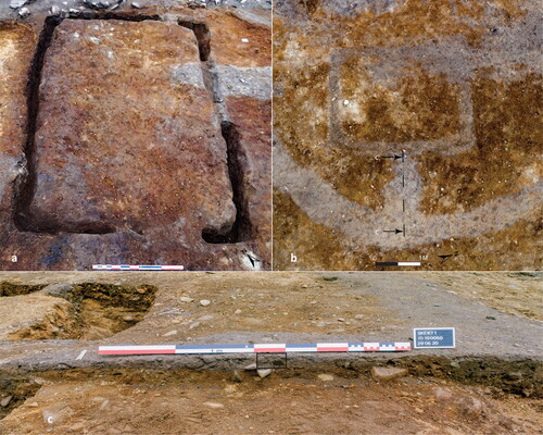
Table 1 Identified and unidentified osteological remains from the wall trenches of G9 and G13. Data from Kjellstöm et al. (Citation2021).
Fig 10 Ferrous finds from the wall trenches.
(A) T28278:1, arrowhead from G13. (B) T28278:2, nail from G13. (C) T28476: 2, arrowhead from G18. (D) T28274: 1, probable iron nail from G9. Photograph by Stian Ingdahl, © NTNU University Museum.
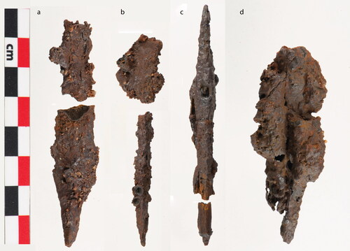
Fig 11 Oxcal calibration plot with the bayesian modell of the 14 C-dates from the mortuary houses, and the related features used as constrains (oxcal v 4.4 Bronk Ramsey Citation2021; atmospheric data from Reimer et al Citation2020). Information on the sampled material for each date is available in . The two outliers (in red) are not included in the calculation of the result.
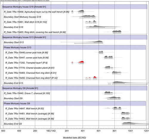
Table 2 List of 14 C dates from the mortuary sites and stratigraphically relevant features. Tra14461 and Tra-14463 are calculated as an average of two measurements from each sample (in italics). Outliers (in bold) is not included in the model ().
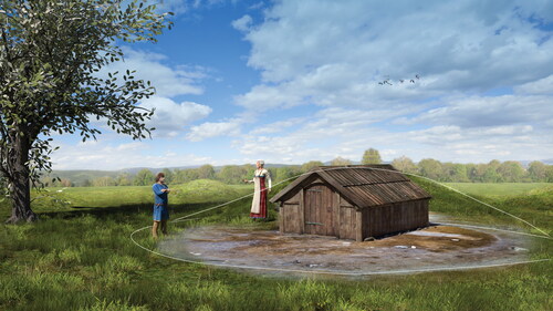
Fig 12 Artist’s interpretation of the G13 mortuary structure during use. The conjectured lines indicate the possible outline of the burial mound. Illustration by Arkikon, © NTNU University Museum.