Figures & data
Figure 1. The location of the study area in the Northern Apennines.
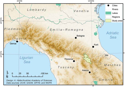
Table 1. Population changes in the municipalities of the Foreste Casentinesi National Park. The formerly separated municipalities of Pratovecchio and Stia form the Comune di Pratovecchio Stia since 2014. Source: Istituto Nazionale di Statistica (Citation1981, Citation1991, Citation2001, Citation2011) and author’s calculations.
Figure 2. Shrub encroachment on grasslands (view from the locality of Briganzone/San Godenzo). Photo: Andreas Haller (2017).
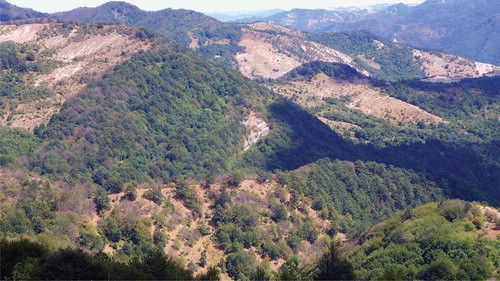
Table 2. Accuracy assessment of the 2010 land cover classification on the basis of 373 reference points from 2014 very high-resolution imagery. Changes between grassland (GRL), wood or shrubland (WSL), and other are shown.
Table 3. Portions and changes of land cover classes 1990–2001 and 2001–2011 in the Foreste Casentinesi National Park (in percent of the total area of 408,998 pixel).
Table 4. Land cover change during 1990–2001 and 2001–2011 (in percent of the total area of 408,998 pixel). Bold figures represent the observed values, and figures in italics show the difference between observed and expected values in terms of gains and losses.
Figure 3. Grasslands in the Foreste Casentinesi National Park. The municipalities of Bagno di Romagna (BRO), Portico e San Benedetto (PSB), Premilcuore (PRE), Santa Sofia (SSO), Tredozio (TRE), Bibbiena (BIB), Chiusi della Verna (CHV), Pratovecchio-Stia (PST), Poppi (POP), Londa (LON), and San Godenzo (SGO) are indicated.
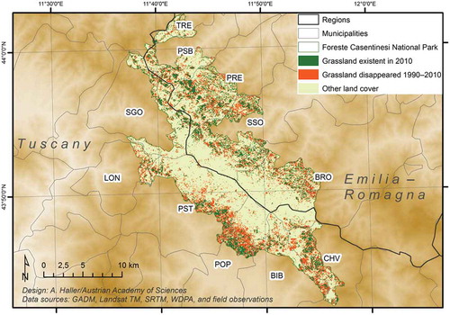
Figure 4. Altitudinal distribution of grassland areas that disappeared during 1990–2010. The highest values are found in the submontane zone (600–1000 m asl), which covers 63% of the park, and where 77% of the park disappeared and 81% of the park’s 2010 grassland is located. Source: Authors’ calculation.
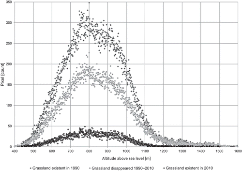
Figure 5. Abandoned settlements (2014) on stable/not on stable grassland are indicated. The municipalities of Bagno di Romagna (BRO), Portico e San Benedetto (PSB), Premilcuore (PRE), Santa Sofia (SSO), Tredozio (TRE), Bibbiena (BIB), Chiusi della Verna (CHV), Pratovecchio-Stia (PST), Poppi (POP), Londa (LON), and San Godenzo (SGO) are indicated.
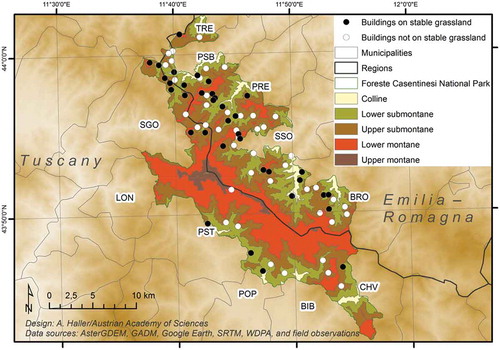
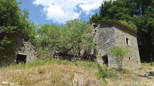
Figure 6. Abandoned settlement at the Romiti plain (now property of the Foreste Casentinesi National Park). Photo: Andreas Haller (2017).