
Figures & data
Figure 1. The main processes involved in constructing the global validation data-set.
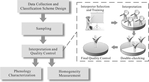
Table 1. Land-cover types in the classification scheme of the validation sample set.
Figure 2. Supplementary data over three sample locations for interpretation from Google Earth. Sample unit A is located in the East Siberian taiga in Russia; sample unit B is an example at Snake-Columbia shrub steppe in the USA; sample unit C is a typical Mediterranean orchard and vineyard in France. (a) Geo-tagged photos shared by visitors on the platform of Google Earth; (b), (d), and (f) latest remotely sensed images on Google Earth; (c) elevation profile for A; (e) historical imagery; (g) screenshots of street view.
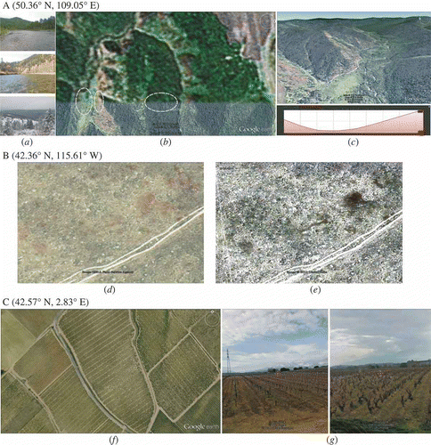
Figure 3. Major processes in phenology characterization. This procedure is run for each sample in the validation data-set.
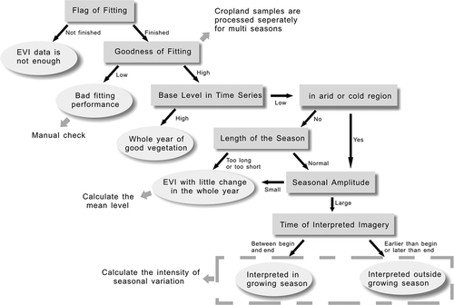
Figure 4. EVI time series of different phenological characteristics. Small arrows along the time axis refer to the approximate acquisition time of Landsat imagery used in this study. The estimated growing season is presented as a grey block in each example.
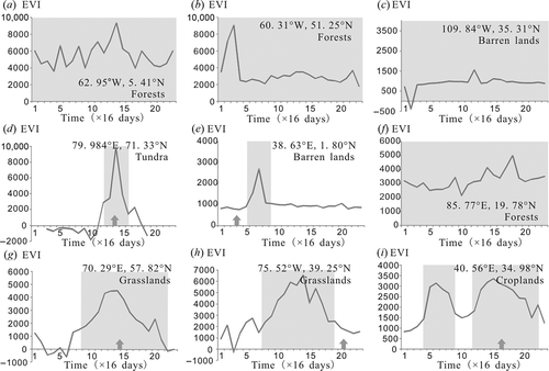
Table 2. Number of sample units for each land-cover class at level 1.
Table 3. Attribute table in the validation data-set. Two records are shown as examples, with explanation in parentheses.
Figure 5. Summary of sample characteristics related to sample uncertainty and applicability.
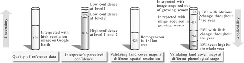
Figure 6. Validation samples with high-resolution imagery available at Google Earth. (a) Spatial distribution of samples with and without high-resolution imagery available at Google Earth; (b) total number of samples for the 10 largest countries and the percentage of samples with high-resolution imagery for each country.
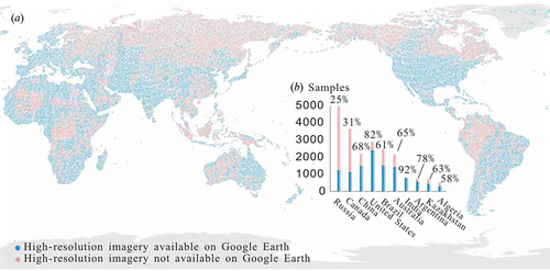
Figure 7. Validation samples interpreted with low confidence at land-cover type level 1. (a) Spatial distribution of the low-confidence samples; (b) number of samples in each land-cover type (solid bars) and percentage of sample interpreted with low confidence at level 1 (dashed lines).
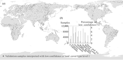
Figure 8. Phenological characteristics of validation samples. (a) Samples ‘green’ for the whole year. (b) Samples with little EVI variation over the whole year; the annual average EVI for this type of sample is denoted by different colours. (c) Samples with obvious EVI change over the whole year; sample colours indicate whether they were interpreted with images acquired during the growing season. (d) Samples with obvious EVI change over the whole year; sample colours indicate the length of growing season fitted with EVI time series.
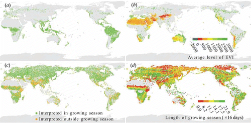
Table 4. Overall accuracies calculated based on homogeneous samples in the data-set presented with a 95% confidence interval and estimated according to the standard error (Olofsson et al. Citation2014).