
Figures & data
Figure 1. Study area is the New Jersey coastal wetland marshes indicated in red. The northern, central, and southern zones are based on the extent and overlap of synthetic aperture radar (SAR) coverage dates. The National Oceanic and Atmospheric Administration (NOAA) hydrograph and NOAA Jacques Cousteau-National Estuarine Research Reserve System (NERRS) sampling stations are denoted by green and yellow dots, respectively. The background is the COSMO-SkyMed (COSMO) image of 30 August 2011. The white rectangle shows the location of .
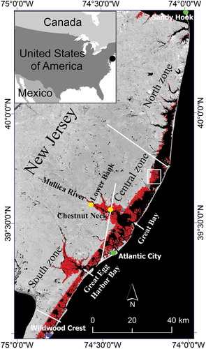
Figure 2. Hurricane Sandy surge flooding extents as obtained from COSMO-SkyMed (COSMO) and TerraSAR-X (TSX) radar images. (a) Surge extent using National Oceanic and Atmospheric Administration (NOAA) model and Atlantic City water levels; (b)–(f) surge flood extents in green on different dates of radar data. The extent of coverage of each radar collection is shown by the dotted white line on the respective dates. The background is the COSMO image of 30 August 2011. Coverage extent is the same as in .
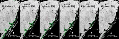
Figure 3. Surge persistence maps based on the commonality of synthetic aperture radar coverage for the central (a) and southern (b) zones (see ). Note the different compositions of surge persistence in each zone. The background is the COSMO image of 30 October 2012. See supplemental Figure S4 (a) for the northern zone.
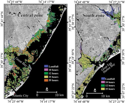
Figure 4. (a) 31 October 2012 synthetic aperture radar image, (b) topography in the depiction (the approximate range is 0.9 m (high) to 0.3 m (low)), and (c) flood persistence map. The white rectangle on shows the location of this area.
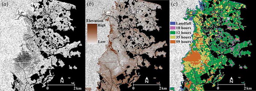
Table 1. Synthetic aperture radar data characteristics and acquisition times and water levels recorded at the National Oceanic and Atmospheric Administration (NOAA) Atlantic City station. The water level was 1.87 m at 24:00:00 UTC when Hurricane Sandy made landfall on 29 October 2012.
Table 2. Salinity and water levels from the two National Oceanic and Atmospheric Administration (NOAA)-National Estuarine Research Reserve System (NERRS) sampling stations.
Table 3. Optical Satellite Pour l’Observation de la Terre (SPOT) 5 multispectral data characteristics and acquisition times and water levels from two National Oceanic and Atmospheric Administration (NOAA) hydrograph stations.
Figure 5. (a) and (b) show marsh condition change maps generated using optical Satellite Pour l’Observation de la Terre (SPOT) data; (c) and (d) show marsh condition change maps generated using optical satellite Moderate Resolution Imaging Spectroradiometer (MODIS) data. The arrow in Figure 5(a) and 5(c) denotes a region of non-coincidence in SPOT and MODIS marsh condition mapping. Zone locations are shown on and coverage extents are the same as in and . See supplemental Figure S4 (b) for northern zone SPOT marsh condition map.
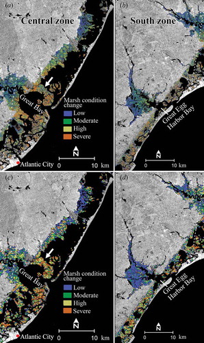
Figure 6. Coincidence matrix showing spatial association between surge persistence and Satellite Pour l’Observation de la Terre (SPOT) marsh condition change maps for (a) central zone and (b) southern zone. Zones are shown on . The background is the COSMO image of 31 October 2012. See supplemental Figure S4 (c) for northern zone coincidence matrix.
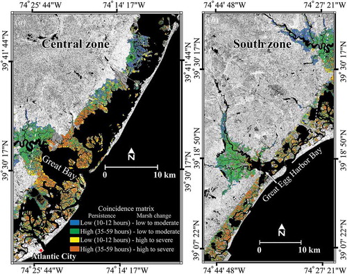
Table 4. Optical data marsh condition change normalized difference vegetation index (NDVI) classes and statistics.
Table 5. Coincidence matrix result for the surge persistence and marsh condition change maps. The reference surge persistence (landfall), as well as persistence 10 and 12 h after landfall, were categorized as low persistence, and 35 and 59 h after landfall were categorized as high persistence. The low and moderate marsh condition changes were depicted as low, and the high and severe marsh condition changes as high. to describe the matrix associations. The same colours are used in to illustrate spatial distribution. The ‘Total’ row in each zone shows the total area in hectares (ha) represented by each colour per zone.